BlockBefore
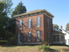
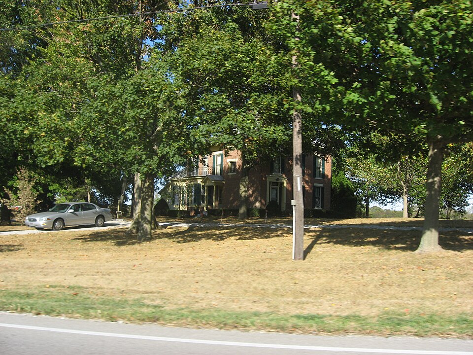
Photograph of Van Nuys Farm
Photograph by Nyttend, Public domain. Via Wikimedia Commons.

Van Nuys Farm

Listed on the National Register of Historic Places in 1987.

From the record

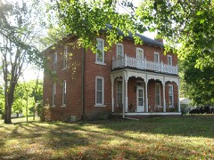
“Van Nuys Farm, also known as the Van Nuys Homestead, is a historic home and farm located in Franklin Township, Johnson County, Indiana, United States. The house was built in 1866, and is a two-story, Greek Revival style brick dwelling with a hipped roof.”

Wikipedia article Van Nuys Farm, CC BY-SA 4.0.

One of 22 National Register listings published here for Johnson County · listed in 1987 · category: Building.

Sources: the Wikipedia article · the case file at the National Archives · the National Register database, National Park Service
The listing

  • What is counted as historic. The nomination lists 11 buildingss as contributing to the listing.
  • Address. IN 144, Hopewell, 46131
  • When was it listed? February 1987
  • Category. building
  • Township. Franklin township
  • National Register reference number. 87000100 - the number the National Park Service assigned this property when it was listed, and the key its nomination file is catalogued under at the National Archives.

The ground it stands on

10,529 words

The chapter on Franklin Township in A Historical Sketch of Johnson County, Indiana, published 1881 names Hopewell. This is what it says, exactly as the scans read.

In another place (Chap. VII) is an account of the drift of settlement in Franklin Township, and it only remains to add such of the names of the pioneer settlers as the memories of those caring to impart their knowledge will give. In 1825, Moses Freeman, Daniel Covert, Joseph Voris, Thomas Henderson and, probably, John Davis, moved into and not far from the Covert neighborhood, at the Big Spring, near Hopewell. Henry Byers settled near the west side, and about the same time Joseph Hunt came in by Burkhart's, and Isaac Beeson over on Sugar Creek. John Smiley, in 1822, had settled on the same creek and had built a mill. John Mozingo and Squire Hendricks were living on the east side, as heretofore stated.

Passage source: A Historical Sketch of Johnson County, Indiana, published 1881.

Peter D. and Aaron, all then settled in what is now known as the Hopewell neighborhood. Following, at intervals, during the next few years, we find coming into the same vicinity John Voris, Simon Vanarsdall, Zachariah Ransdall, Cornelius Covert, Melvin Wheat, John P. Banta, John Bergen, Peter Demaree, Samuel Vannuys, Theodore List, Stephen Whitenack, Joseph Combs, Thomas Roberts and Peter Banta. On the south and west sides and southwest corner of the township, we find that Thomas Mitchel, Michael Canary, Robert McAuly, Jacob Demaree, Ebenezer Perry, James Forsyth, came in quite early, and then passing up the south side are the names of Major Townsend, John D. Mitchel, John Gratner, Joseph Ashly, John Harter, Alexander McCaslin, James McCaslin, John C. Goodman, John Gribben, and Jonathan Williams. In the central and northern parts were Wm. Magill, Garrett Bergen, Peter A. Banta, Milton Utter, the Whitesides brothers - Henry, James, John and William - and Stephen and Lemuel Tilson, Thomas J. Mitchel, John Brown, Elisha Dungan, Edward Crow, David McCaslin, Harvey McCaslin, Robert Jeffrey, John Herriott, Middleton Waldren, Therrett Devore, Travis Burnett, David Berry, Jesse Williams, Simon Moore, John High, Samuel Overstreet, John Wilson, David, Thomas and George Alexander, William and Samuel Allison and John Wilson ; while upon the east side, in addition to those mentioned in Chapter VII, may be named Landen Hendricks, William Garrison, Joseph Tetrick, Jesse Beard, Thomas Needham, Jacob Fisher, Samuel Owens, David Wiles and J. C. Patterson.

Passage source: A Historical Sketch of Johnson County, Indiana, published 1881.

Machine-read from a century-old scan, so expect the errors a machine makes: misspelled names, dropped words, stray characters.

Read the whole chapter on Franklin Township - 10,529 words on its settlement, mills, schools and churches.

Storms near this property

4 since 1995

Regional context, not property-specific evidence. The National Weather Service names Hopewell, the town this property stands in, in 4 storm reports between 1995 and 2023: 3 thunderstorm wind, 1 tornado. No death or injury is recorded in these reports. Each account below is quoted exactly as the forecast office filed it, from the NOAA Storm Events Database, and each date opens the federal record of that event.

WhenEvent Place namedHarm What the report says
March 2023Tornado (EF0)Hopewell$800,000This was the rotating supercell's fourth tornado, and the first and weaker of two tornadoes spawned in Johnson County. The tornado started to the north-northeast of the village of Providence, although most of the sporadic tree damage noted in the town was from straight line winds, with slightly more intense tree damage seen from the tornado. The tornado continued to move east-northeast and crossed Indiana Route 135, with multiple power lines damaged and downed across the highway. Metal roofing of a barn just east of Route 135 was peeled back from winds nearing 85 mph. The tornado continued to the east-northeast towards Indiana Route 144, but lifted just before reaching this highway, southeast of Bargersville. Sporadic tree damage was noted to the south of Route 144.
August 2023Thunderstorm WindHopewell$1,000Thunderstorm winds downed a few small to medium sized tree branches, while flattening an approximate one-third acre of soybean crop.
August 2019Thunderstorm WindHopewell-An estimated 65 mph thunderstorm wind gust was reported at this location.
May 1995Thunderstorm WindHopewell-Thunderstorm winds blew a large tree and power lines down. A large permanent sign was blown down on Interstate 65 near Whiteland.

Every storm recorded in Johnson County

Map coverage status

No historic map-sheet match is published for this property yet. That does not mean no map exists. This record needs a coordinate-quality review before it can be joined to a sheet boundary. Browse the county's mapped places while that work is pending.

Listed places nearby

6 within 8 miles

Other National Register properties close enough to walk or drive between, ordered by distance from this one. Both positions come from the same geocoding pass that matched these properties to their map sheets.

Photograph PropertyDistance Listed
Hopewell Presbyterian Church0.4 miles2000
Bethel African Methodist Episcopal Church3.3 miles2015
August Zeppenfeld House3.4 miles1987
Herriott House3.4 miles1982
Greenlawn Cemetery3.5 miles2013
Martin Place Historic District3.6 miles1987

Sources for this property

National Archives recordThe nomination case file for reference 87000100 in Record Group 79.
Wikipedia articleCommunity-written account of this property, licensed CC BY-SA.
Johnson CountyAll 22 listed properties in this county.

Provenance

  • Listing record. National Park Service National Register of Historic Places, listed-properties dataset, current to 2026-05-22.
  • Map join. Address geocoded through the United States Census geocoder, then tested against the published boundary of every sheet in the USGS Historical Topographic Map Collection.
  • How this page is made. Listing fields come from federal records; map-sheet coverage is a labelled coordinate-to-boundary calculation, not a source-field claim.
  • Storms. NOAA National Centers for Environmental Information, Storm Events Database https://www.ncei.noaa.gov/stormevents/ A work of the United States government, no copyright under 17 U.S.C. 105. Narratives are quoted verbatim from the National Weather Service report and are not edited or summarised.