
BlockBefore
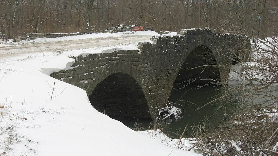
Photograph of Scotland Bridge
Photograph by Nyttend, Public domain. Via Wikimedia Commons.

Scotland Bridge

Listed on the National Register of Historic Places in 1994.

From the record

“Scotland Bridge, also known as Boone County Bridge #41, was a historic segmental arch bridge located at Clinton Township, Boone County, Indiana. It was built 1901 and rebuilt in 1908, and was a 120 feet (37 m), three-span bridge built of Indiana limestone.”

Wikipedia article Scotland Bridge, CC BY-SA 4.0.

One of 13 National Register listings published here for Boone County · listed in 1994 · category: Structure.

Sources: the Wikipedia article · the case file at the National Archives · the National Register database, National Park Service

The listing

  • Listing status. The Park Service records this property as Removed.
  • What is counted as historic. The nomination lists 1 structure as contributing to the listing.
  • Address. Lost Rd. (Co. Rd. 200 E) over Sugar Cr., Mechanicsburg, 46050
  • When was it listed? March 1994
  • Category. structure
  • Township. Clinton township
  • National Register reference number. 94000228 - the number the National Park Service assigned this property when it was listed, and the key its nomination file is catalogued under at the National Archives.

The ground it stands on

2,960 words

The chapter on Clinton Township in Early Life and Times in Boone County Indiana, published 1861; History of Boone County, Indiana : With Biographical Sketches of Representative Citizens and Genealogical Records of Old Families, published 1914 names Mechanicsburg. This is what it says, exactly as the scans read.

This township is the east center and in the north tier of townships adjoining Clinton County. It contains thirty-three square miles, six miles from east to west and five and one-half miles from north to south. Sugar Creek enters it at the northwest corner, cutting off about one section. Mud Creek and Brown's Wonder flow through the township in a northwestern direction and empty into Sugar Creek, the former just north of the center of the township in the edge of Clinton County, and the latter entering near Mechanicsburg in Washington Township. Tarepin Creek, or branch, also flows in the same direction. The soil is productive, and rapid improvements are being made in the way of ditching. The streams above referred to drain it naturally and afford an outlet to the countless ditches now being put in. The timber of this township at one time must have been grand, as there are yet standing some fine specimens of oak. The demand for walnut, poplar and cherry has about exhausted this once bountiful supply. The pioneers of this township had this to contend with in making their farms. Some of the finest timber was burned up and destroyed. There was no demand for lumber at that time. No doubt there has been enough timber burnt and destroyed to pay for the land at fifty dollars per acre. Among the early settlers of this part of the county we mention Jas. H. Sample, Geo. Fall, Henry I. Bennett, Robert Stephenson, A. B. Clark, Hoza Aldridge, Resin V. Garrett, Thos. Abernathy, Wm. West, David Evans, John Tucker, Jesse Scott, Hiram Roberts, Jesse Perkins, John Caldwell, Wm. I. Bennett, Newton Cassadav, John M. Burns, Hiram Brenton, Alexander Caldwell, (ieo, Mognett, Jas. Downing, Hugh

Passage source: Early Life and Times in Boone County Indiana, published 1861.

Clinton township is situated in the northern tier of townships bounded on the north by Clinton county, on the west by Washington township, on the south by Center and on the east by Hamilton county. It contains thirtythree sections of land. Half sections 13 to 18 inclusive, and sections 19 to 36 inclusive, in township 20 north, range 1 east, and sections 1 to 12 inclusive, in township 19 north, range 1 east. Its surface is generally level, sloping gently towards the northwest. Section 12 in the southwest corner is the highest and most level in the township, and the northwest corner is the lowest and most broken. Sugar creek cuts off a small portion of the northwest corner. Mud creek, Terrapin creek and Brown's Wonder, all flow toward the northwest and drain the entire township into Sugar creek. There is a story about the origin of the name of this latter creek. It is stated that when the surveyors were surveying this part of Boone county and came across the head waters of this stream in Center township and it twisted and flowed in so many directions that much controversy arose among them as to where the creek would empty. It was no easy work to survey this wild land. To cut a way through the brush and wade through the bogs and lazy crooked streams was a tedious task. Added to this was the difficulty of telling a stream that was lost in the woods from a regular bog or swamp. This sluggish, twisting stream was a wonder to all three of the men and especially to a young man of the company by the name of Brown. So when the riddle was solved and the perplexed stream was landed in Sugar creek, near Mechanicsburg, it was christened Brown's Wonder. The streams previously referred to drained the township naturally and made it easy to complete the work by ditching so that the rich soil was easily drained. The township is comparatively level except the northwest corner, and yet there were only forty acres of swamp land in the entire township, the southwest one-fourth of southwest quarter of section 2.

Passage source: History of Boone County, Indiana : With Biographical Sketches of Representative Citizens and Genealogical Records of Old Families, published 1914.

Machine-read from a century-old scan, so expect the errors a machine makes: misspelled names, dropped words, stray characters.

Read the whole chapter on Clinton Township - 2,960 words on its settlement, mills, schools and churches.

Storms near this property

5 since 1997

Regional context, not property-specific evidence. The National Weather Service names Mechanicsburg, the town this property stands in, in 5 storm reports between 1997 and 2023: 2 thunderstorm wind, 2 hail, 1 flash flood. No death or injury is recorded in these reports. Each account below is quoted exactly as the forecast office filed it, from the NOAA Storm Events Database, and each date opens the federal record of that event.

WhenEvent Place namedHarm What the report says
June 1997Thunderstorm WindMechanicsburg$500Trees blown down.
June 2023HailMechanicsburg-Thunderstorm hail as large as hen eggs fell across far northern Boone County from Mechanicsburg and east.
May 2014HailMechanicsburg-This report came in from near the intersection of County Roads 200 East and 850 North.
June 2004Flash FloodMechanicsburg-no account filed
July 2003Thunderstorm WindMechanicsburg-no account filed

Every storm recorded in Boone County

Map coverage status

No historic map-sheet match is published for this property yet. That does not mean no map exists. This record needs a coordinate-quality review before it can be joined to a sheet boundary. Browse the county's mapped places while that work is pending.

Listed places nearby

1 within 8 miles

Other National Register properties close enough to walk or drive between, ordered by distance from this one. Both positions come from the same geocoding pass that matched these properties to their map sheets.

Photograph PropertyDistance Listed
Ulen Historic District7.9 miles2015

Sources for this property

National Archives recordThe nomination case file for reference 94000228 in Record Group 79.
Wikipedia articleCommunity-written account of this property, licensed CC BY-SA.
Boone CountyAll 13 listed properties in this county.

Provenance

  • Listing record. National Park Service National Register of Historic Places, listed-properties dataset, current to 2026-05-22.
  • Map join. Address geocoded through the United States Census geocoder, then tested against the published boundary of every sheet in the USGS Historical Topographic Map Collection.
  • How this page is made. Listing fields come from federal records; map-sheet coverage is a labelled coordinate-to-boundary calculation, not a source-field claim.
  • Storms. NOAA National Centers for Environmental Information, Storm Events Database https://www.ncei.noaa.gov/stormevents/ A work of the United States government, no copyright under 17 U.S.C. 105. Narratives are quoted verbatim from the National Weather Service report and are not edited or summarised.