
BlockBefore
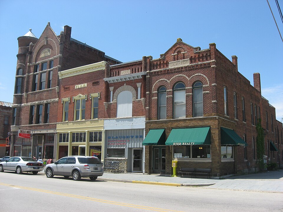
Photograph of Farmland Downtown Historic District
Photograph by Nyttend, Public domain. Via Wikimedia Commons.

Farmland Downtown Historic District

Listed on the National Register of Historic Places in 1994.

From the record

One of 12 National Register listings published here for Randolph County · listed in 1994 · category: District.

Sources: the case file at the National Archives · the National Register database, National Park Service · the Wikipedia article
The listing

What happened here

An account from the chapter on Monroe township. The inset identifies its exact source book and publication year.

From History of Randolph County, Indiana with Illustrations and Biographical Sketches of Some of Its Prominent Men and Pioneers : to Which Are Appended Maps of Its Several Townships, published 1882 - Monroe Township

Deer Hunting

" next day I killed my second deer. I had killed the first deer near Overman's. I shot that first deer, and asked him to help carry it in. 'No,' said Overman, ' I can't leave planting corn. You just take it on your shoulders, and its tail between your teeth, and climb a sapling and hang it up.' I didn't do it, however.

Read the rest of this passage

The ground it stands on

73,141 words

The chapter on Monroe Township in History of Randolph County, Indiana with Illustrations and Biographical Sketches of Some of Its Prominent Men and Pioneers : to Which Are Appended Maps of Its Several Townships, published 1882 names Farmland. This is what it says, exactly as the scans read.

There is a bridge across White River east of Winchester, and one on each of the pikes leading thence to Union City, one across White River northwest of Winchester, one still west of that, one south of Farmland, and one near Parker. There is a large bridge across Stony Creek east of Windsor on the Winchester Pike. There are, of course, bridges innumerable across the several creeks that course through the county in various directions.

Passage source: History of Randolph County, Indiana with Illustrations and Biographical Sketches of Some of Its Prominent Men and Pioneers : to Which Are Appended Maps of Its Several Townships, published 1882.

John Rody, S. E S. E. 17, 20, 12, 40, April 10. 183:5; Jeremiah B. Reed, N. E. S. E. 34, 21, 12. 40, October 21, 1833; Philip Baughn, W. S. E. 20, 21, 12, 80, June 10, 1834; Morgan Mills, S. E. S. E. 8, 20, 12, 40, October 2, 1834; Bernard Kerr,W. N. AV. 35, 21. 12, 80, August 5, 1834: Joseph Smith, N. W. S. W. 2, 20, 12, 40, Junuai-y 22, 1835; Henry Rash. N. E. S. E. 17, 20, 12, 40, March 23, 1835; Abraham Gai-st, S. E. 14, 20, 12,80, June 17, 1835. Monroe wtis mostly taken between 1835 and 1838 inclusive, chietiy during the years 1836 and 1837. Two entries, fort\' acres each (as above), were made in the 1833, three in 1834 and three in 1835 to June 17. Eight entries, embracing 440 acres - five forties and three eighties - comprise all the entries up ti.i June 17. 1835, throughout the entire extent of Monroe Townshiji. It may be intere.'-.ting to know where these eight pioneer entries were: John Rody. one mile south of Morristown. forty acres; Jeremiah B. Reed, on West Branch of Elkhorn. five miles northwe.st of Farmland, forty acres; Philip Baughn, on same branch of Elkhorn. one and a half miles below Reed's, eighty acres; Morgan Jlills, onehalf mile north of Morristown, forty acres: Bernard Kerr, on Elkhorn, right below Reed's, eighty acres; Joseph Smith, at the IMothodist Episcopal Church, on AVest Branch of Elkhorn, above Reed's, forty acres: Henry Rash, just south of Morristown, forty acres; Abraham Garst, one mile southwast of Farmland, and one and a half miles northea.st of the month of Cabin Creek, eighty acre.s. Three of them were near Morristown - one north and two south of it. Four were above the West Branch of Elkhorn to its junction with the East Branch. One was southwest of Farmland. About that time it would seem that several had come in. perhaps selecting their claims and settling previous to making entries of their land. From one who came in in 1835, we obtain the following statement of settlers living in the region in 1835: Jeremiah B. Reed, near Rehoboth Meoting-House; James Howry, north of Rehoboth; Mr. Carr, north of Rehoboth, on the Isaac Thornburg place; Samuel Smith, on the Adams farm, north of Rehoboth; Philip Booker, across from Abram Hammer's; Isaac Gairinger, on the State roiid, north and south; Jonathan Flood, in 183(5, near Hopewell Church, a Prott>stant Methodist minister; John F. Wood, William Wood, in northwest corner of township: Moses Marks, north of Parker; John Baughn, in the edge of Delaware County, who was married twice, and has had twenty-six children - sevont<'en by his first wife and nine by the second - and is still living, seventy-three years old; John B. Mills, north of Shiloh, date not known; Andrew (^ortner, west of Shiloh, date not given. Other settlers on Elkhorn, northwest of li'annland were: Messrs. Hammer, Booker, Adams, Qarringer, MoCarney, Peter Hester, etc., etc. Eli Hiatt came in and settled one-half mile south of Farmland in 1830. Isaac Garringer "planted his stakes" on Elkhorn, three miles northwest of Farmland, about the same time. Peter Hester came on Bush Creek in 1S30, perhaps the first on Bush Creek. Mr. Bowera bought out Mr. Hester soon after. On Elkhorn, in 1836 (or thereabout), were Jonathan Reeples, Jeremiah Reed, Abraham Hammer, Joseph Smith (where Harrison Morris now lives), Mr. Carr (where Isaac Thornbiug now resides). Philip Booker came on Bush Creek about the same time that Peter Hester did. Henry Adams settled near Abraham Hmnmer's in 1835. Alfred McCarney, one and a half miles north of Hammer's, 1835; Jacob Wright, one-half mile south, 1835; Jacob Windermaker, onehalf mile north of Rehoboth. John Craig came in 1845; resides now at Reholxjth. Joseph Howrey, east of Rehoboth; Joseph Smith, an old man, south of Rehoboth; James Wood, Mr. Sawyer and William Wood, northwest part of the township; Peter Hester, William Vineyard, William Paxson, Henry Saley, Mr. Ovorhulser, William Gray and Eli Jamagin (the last throe in Green Township). In fact, Green Township was settled before Monroe, (ยป40 acres being settled in 1832. in six entries; thirteen entries made in 1833, comprising 5120 acres; seven entries made in 1834, including 6lK) acres; and eight euti'ies in 1835, covering some 400 acres - or thirty-four entries in all, with about 2,- 500 acres; or, in both townships, forty-two entries, with 3,000 acres. And of the whole number, only five contained 1(50 acres, and they were all in Green Township; twenty-two were forty acres each, and fifteen were eighty acres each.

Passage source: History of Randolph County, Indiana with Illustrations and Biographical Sketches of Some of Its Prominent Men and Pioneers : to Which Are Appended Maps of Its Several Townships, published 1882.

Machine-read from a century-old scan, so expect the errors a machine makes: misspelled names, dropped words, stray characters.

Read the whole chapter on Monroe Township - 73,141 words on its settlement, mills, schools and churches.

Mines and quarries near this property

1 within 5 miles

Regional context, not property-specific evidence. The federal mineral resources record lists 1 working within 5 miles of Farmland Downtown Historic District: 1 producer. All of them still produce. What was taken out: Sand and Gravel, Construction. Distance is straight-line from the map coordinates, so a quarry counted here may appear on a neighbouring settlement's page as well.

Where SiteCommodity StatusRecorded
H & S Materials PitSand and Gravel, ConstructionProducer

Every working recorded in Randolph County

Storms near this property

23 since 1996

Regional context, not property-specific evidence. The National Weather Service names Farmland, the town this property stands in, in 23 storm reports between 1996 and 2025: 15 thunderstorm wind, 3 hail, 3 flash flood, 1 lightning. The reports record 1 death and 37 injuries. Each account below is quoted exactly as the forecast office filed it, from the NOAA Storm Events Database, and each date opens the federal record of that event.

WhenEvent Place namedHarm What the report says
March 2024Tornado (EF3)Farmland1 killed, 37 hurt, $25,000,000The Selma tornado lifted in the open area and fields between|eastern Delaware county to near Farmland before redeveloping. As it|moved through Rural Randolph county it bent or snapped numerous|utility poles along State Road 32. Also, a large blade on one of|the wind turbines in the area was badly damaged.||As the tornado entered Winchester, it severely damaged many homes|and snapped and uprooted trees in a west-to-east path through|Winchester. There was clear evidence of the tornado`s rotational|circulation, with uprooted trees pointed to the east on the|immediate south side of the tornado, and to the northwest on the|immediate north side of the tornado. The damage pattern also|indicated the possibility of small multiple vortices rotating|around the main vortex. In the residential core of the town, the|maximum intensity of the tornado was estimated around 130 mph or|high-end EF2 strength.||The greatest damage in Winchester occurred on the east side of|town at the Taco Bell, as the anchored building was destroyed, as|was a church immediately east of the restaurant. In this|concentrated area, the NWS Team estimated maximum winds of 155-165|mph, or high- end EF3 damage. Maximum path width in Winchester|was estimated at up to 0.4 mile or 700 yards.||Farther east across more rural eastern Randolph County, a few|structures had significant damage, debris was blown in fields,|many trees were snapped, and a silo was damaged, all indicative of|EF2 maximum damage in the 115-125 mph range.||The tornado continued to the Indiana-Ohio state line, with less|intense damage primarily to trees before crossing into Ohio.
July 2011Thunderstorm WindFarmland$40,000Multiple utility poles and trees were reported down with minor structural damage due to damaging thunderstorm wind gusts.
May 2015Thunderstorm WindFarmland$35,000Numerous trees were reported down across the Farmland area due to damaging thunderstorm wind gusts. Trees were reported to be down on a residence, unoccupied vehicles, and down across a road blocking traffic.
June 1998LightningFarmland$20,000Lighning caused fire partially destroying home.
September 2014Thunderstorm WindFarmland$12,000Some structures and trees sustained damage from damaging thunderstorm wind gusts. Utility lines were also downed. This report was received via social media.
March 2020Flash FloodFarmland$10,000Rapidly rising water led to several cars to be stranded in high water across portions of Randolph County. Several roads were closed due to the rapidly rising water.
June 2025Thunderstorm WindFarmland$5,000Thunderstorm wind gust damage occurred to a front yard tree and a garage.
July 2016Thunderstorm WindFarmland$3,000Trees were down in Muncie due to damaging thunderstorm wind gusts.
August 2021Thunderstorm WindFarmland$1,000Tree downed by winds onto powerlines.
August 1998Thunderstorm WindFarmland$1,000Trees and power lines blown down.
May 2004Thunderstorm WindFarmland-Large tree limbs down.
June 2002HailFarmland-Trained spotter reported golfball size hail.
May 2000Thunderstorm WindFarmland-County sherriff reported power lines down.
May 2006HailFarmland-no account filed
January 2005Flash FloodFarmland-no account filed
May 2004Thunderstorm WindFarmland-no account filed
July 2003Flash FloodFarmland-no account filed
July 2003Thunderstorm WindFarmland-no account filed
May 2000HailFarmland-no account filed
May 1999Thunderstorm WindFarmland-no account filed
August 1998Thunderstorm WindFarmland-no account filed
May 1996Thunderstorm WindFarmland-no account filed

Every storm recorded in Randolph County

Map coverage status

No historic map-sheet match is published for this property yet. That does not mean no map exists. This record needs a coordinate-quality review before it can be joined to a sheet boundary. Browse the county's mapped places while that work is pending.

Listed places nearby

1 within 8 miles

Other National Register properties close enough to walk or drive between, ordered by distance from this one. Both positions come from the same geocoding pass that matched these properties to their map sheets.

Photograph PropertyDistance Listed
Gen. Asahel Stone Mansion7.9 miles1979

Sources for this property

National Archives recordThe nomination case file for reference 94001124 in Record Group 79.
Wikipedia articleCommunity-written account of this property, licensed CC BY-SA.
Randolph CountyAll 12 listed properties in this county.

Provenance

  • Listing record. National Park Service National Register of Historic Places, listed-properties dataset, current to 2026-05-22.
  • Map join. Address geocoded through the United States Census geocoder, then tested against the published boundary of every sheet in the USGS Historical Topographic Map Collection.
  • How this page is made. Listing fields come from federal records; map-sheet coverage is a labelled coordinate-to-boundary calculation, not a source-field claim.
  • Mines and quarries. USGS Mineral Resources Data System (MRDS) https://mrdata.usgs.gov/mrds/ A work of the United States government, no copyright under 17 U.S.C. 105.
  • Storms. NOAA National Centers for Environmental Information, Storm Events Database https://www.ncei.noaa.gov/stormevents/ A work of the United States government, no copyright under 17 U.S.C. 105. Narratives are quoted verbatim from the National Weather Service report and are not edited or summarised.