 Block
From the record
6 National Register listings published here.
Sources: the National Register database, National Park Service
52 topographic sheets cover 14 settlements here, and 6 properties are on the National Register of Historic Places.
6 National Register listings published here.
Sources: the National Register database, National Park Service
Every property in this county listed on the National Register of Historic Places, with the year it was listed and the federal nomination document.
| Photograph | Property | Type | Listed | Reference |
|---|---|---|---|---|
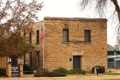 | Allen County Jail | building | 1971 | 71000300 |
 | City Square Park Bandstand | structure | 2014 | 13001036 |
| Iola Theatre | building | 2024 | 100009703 | |
| Kress Building (S.H. Kress & Company Store) | building | 2022 | 100008240 | |
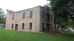 | Lander's Wagon and Carriage Shop | building | 2017 | 100000494 |
 | Northrup House | building | 1997 | 97000395 |
Every wildfire the federal occurrence database records inside this county: 168 of them, burning about 4,967 acres. None started naturally and 23 were recorded as arson. Each settlement page carries the fires within five miles of it.
| Reported cause | Fires |
|---|---|
| Debris and open burning | 66 |
| Missing data/not specified/undetermined | 39 |
| Equipment and vehicle use | 27 |
| Arson/incendiarism | 23 |
| Smoking | 7 |
| Recreation and ceremony | 4 |
| Fireworks | 2 |
The five largest, by the area the report gives. One of them was set deliberately.
| Date | Cause | Size | Reported by | Name on the report |
|---|---|---|---|---|
| 23 August 2012 | Missing data/not specified/undetermined | 3,200 acres | Kansas Counties | MINNESOTA ROAD |
| 11 November 2015 | Equipment and vehicle use | 130 acres | Kansas Forest Service | 2015043 |
| 28 April 2018 | Debris and open burning | 120 acres | Kansas Forest Service | 2018024 |
| 10 February 2016 | Equipment and vehicle use | 100 acres | Kansas Forest Service | 2016013 |
| 5 March 2015 | Debris and open burning | 90 acres | Kansas Forest Service | 7 |
| 12 March 2018 | Missing data/not specified/undetermined | 80 acres | Kansas Forest Service | 2018005 |
| 15 March 2015 | Arson/incendiarism | 80 acres | Kansas Forest Service | 65 |
| 11 March 2015 | Debris and open burning | 80 acres | Kansas Forest Service | 55 |
Every settlement page carries the fires within five miles of it - see the settlement index below.
The NOAA Storm Events Database holds 439 reports for this county, causing no deaths, 6 injuries and about $15,919,910 in recorded property damage. Each settlement page carries the reports that name it.
| Kind of event | Reports |
|---|---|
| Hail | 195 |
| Thunderstorm Wind | 140 |
| Flood | 31 |
| Tornado | 26 |
| Flash Flood | 24 |
| Heavy Rain | 20 |
| Lightning | 2 |
| Funnel Cloud | 1 |
The most serious of them, by death, then injury, then recorded damage. The accounts are quoted exactly as the forecast office filed them.
| When | Event | Place named | Harm | What the report says |
|---|---|---|---|---|
| May 1971 | Tornado (F1) | not stated | 3 hurt, $25,000 | no account filed |
| March 1991 | Tornado (F2) | not stated | 1 hurt, $2,500,000 | no account filed |
| May 2009 | Thunderstorm Wind | Petrolia | 1 hurt, $10,000 | A vehicle was rolled on the Kansas Turnpike near Cassoday. One person was injured (direct). |
| June 2021 | Thunderstorm Wind | Iola | 1 hurt | A large tree was uprooted with numerous other reports of tree and limbs down. One tree fell on top of a car. |
| July 2007 | Flash Flood | Iola | $6,000,000 | Extremely heavy rainfall from the end of June into early July caused flash flooding throughout Allen County. The flash flooding and the ensuing river flooding caused an estimated 3 million dollars in damages to private property and 3 million dollars in damage to public infrastructure. Additionally, the flood water damaged and estimated 8,000 acres of crops. Moderate flooding occurred on the Neosho River with a crest of 26.9 feet recorded at Iola. This was 11.9 feet above flood stage. The river remained above flood stage until the afternoon of July 3rd. |
| March 1982 | Tornado (F2) | not stated | $2,500,000 | no account filed |
| October 2016 | Thunderstorm Wind | Humboldt | $750,000 | A large area of damaging downburst winds moved across the town of Humboldt. The downburst winds were produced by the rear flank downtraft from a supercell thunderstorm as it moved just to the northeast of town. Numerous large trees were blow down. Some of the trees were almost 3 to 4 feet in diameter. The northwest side of town was the hardest hit, with most of the tree damage laying over to the west and northwest. A large row of power poles were snapped on the north side of town. Some minor superficial damage occurred to a few buildings in downtown. |
| October 2016 | Flash Flood | Gas | $500,000 | Widespread flooding occurred in Iola. High water approached several homes. The fire department assisted evacuating residents from their homes. Multiple cars were reported stranded due to the high water. |
| May 2003 | Hail | Humboldt | $500,000 | The following sustained damage: The roofs of approximately 80% of all buildings, be it business or residential, require replacement, & approximately 50% of all vehicles. |
| April 1994 | Thunderstorm Wind | Iola | $500,000 | Winds estimated over 100 mph caused extensive damage including recreational vehicles turned over, picture windows and car windows blown out, a garage was moved six inches off its foundation, uprooted trees, and destroyed three barns. |
| April 2014 | Hail | Iola | $350,000 | A prolific hail producing storm dropped large hail across the city of Iola for twelve minutes. The hail ranged in size from tennis ball size (2.5 inches) to ping pong ball size (1.5 inches). There was widespread hail damage to roofs and cars across town. |
| September 2001 | Thunderstorm Wind | Humboldt | $250,000 | Part of a roof (on south side) of a tire business was torn off. A Cement Company also sustained roof damage. A 3rd building had a large door blown off it's hinges. On the city square, a flag pole was broken off. At the town's athletic field, roofs of the dugouts were torn off with numerous cinder blocks dislodged. Tree and power line damage was widespread, including large trees that were "snapped off at ground level". The town was without power for approximately two hours. |
| March 1977 | Tornado (F1) | not stated | $250,000 | no account filed |
| October 2016 | Flash Flood | Iola | $200,000 | The Emergency manager reported flooding of roadways and stranded cars, especially on the west side of Iola and just west of town. |
| June 1998 | Thunderstorm Wind | Moran | $200,000 | Windows blown out and roofs damaged. Numerous trees uprooted inflicting further roof damage and knocking down power lines that left much of Allen County without power for 8 hours. |
| December 2008 | Lightning | Gas | $150,000 | Lightning from a broken line of strong to severe thunderstorms sparked a house fire in the community of Colony during the predawn hours of the 27th. The residence was completely destroyed. Fortunately, no one was home at the time. Information courtesy of the Iola Register. |
| May 2003 | Tornado (F1) | Iola | $150,000 | Damage summary: 4NW Iola: Oil tank toppled, farm vehicle flipped over, several trees shreaded, and power poles snapped. |
| March 2017 | Thunderstorm Wind | Humboldt | $100,000 | A large swath of wind damage occurred from just south of Iola, Kansas to just south of Moran, Kansas. A measured wind gust of 72 mph was recorded at the Iola airport, located south of Iola. There were also several locations that received damage from the strong winds. A mobile home was rolled over and destroyed. A metal barn was blown apart and downed with metal strewn across the area. A garage had it's doors blown in and the roof blown off due to the increase in pressure. |
| March 2002 | Thunderstorm Wind | Iola | $100,000 | Dairy farm hit. Damage summary: Roof blown off a machine shop, a lean-to blown over, downed power lines, and most of the cattle pens that were tossed. One head of cattle sustained minor injuries. One quarter mile east of the dairy farm, a delivery truck was blown onto it's side. |
| August 1998 | Thunderstorm Wind | Iola | $75,000 | Severe thunderstorm winds peeled off a 30-foot by 50-foot section of roofing from a business in Iola. The wind combined with heavy rain to damage much of the office area as well as most of the merchandise. Wind-driven rain also flooded sections of two schools in Iola. |
| June 2010 | Thunderstorm Wind | Humboldt | $65,000 | Five rural telephone poles were knocked down along Old Highway 169 between Iola and Humboldt. Residents were without power for several hours. |
| May 2020 | Thunderstorm Wind | Iola | $50,000 | Numerous trees down in town. At least one tree was down on a house. |
| April 2010 | Thunderstorm Wind | Iola | $50,000 | A violent storm with winds estimated at 80 mph moved through Iola, partially collapsing a truck repair shop roof. The roof was also blown off the building across the street with the chimney partially destroyed. Numerous trees were blown down, some of the trees were three to four feet in diameter. A chimney was blown off the roof of a house crashing into a car. |
| March 2002 | Thunderstorm Wind | Iola | $50,000 | Windows blown out of unspecified number of cars and businesses. Trees and power lines downed. |
| June 1998 | Thunderstorm Wind | Iola | $50,000 | Tree damage, most noteworthy being a 50-foot tree falling onto a car. |
| May 2009 | Flash Flood | Iola | $35,000 | Numerous county roads throughout the county were flooded from 2 to 4 inches of rainfall falling in a very short time period. |
| June 2007 | Flash Flood | Humboldt | $35,000 | Law enforcement reported 1100 Road was closed between Idaho and Hawaii Roads. |
| May 2000 | Thunderstorm Wind | Moran | $30,000 | The high winds destroyed a chicken house, a cattle barn, and a machine shop. |
| August 2001 | Thunderstorm Wind | Iola | $25,000 | Power poles downed. |
| May 1990 | Tornado (F0) | not stated | $25,000 | no account filed |
| May 1986 | Tornado (F1) | not stated | $25,000 | no account filed |
| May 1986 | Tornado (F1) | not stated | $25,000 | no account filed |
| June 1973 | Tornado (F2) | not stated | $25,000 | no account filed |
| April 1964 | Tornado (F2) | not stated | $25,000 | no account filed |
| April 2023 | Thunderstorm Wind | Iola | $20,000 | Tree damage was noted in Iola. |
| May 2020 | Thunderstorm Wind | Iola | $20,000 | Utility poles were snapped in half on the west side of town. |
| April 2015 | Thunderstorm Wind | Iola | $20,000 | Numerous trees were blown down across the county. Several roads were blocked due to downed trees. |
| August 2006 | Thunderstorm Wind | Iola | $15,000 | Two large trees were downed, windows from a house were shattered, and two barns sustained damage. |
| April 2003 | Thunderstorm Wind | Gas | $15,000 | Barn's roof sheared from west side of the structure that housed farm vehicles. |
| May 2000 | Thunderstorm Wind | La Harpe | $12,000 | All of the walls of a garage were blown down causing considerable damage. |
| June 2013 | Thunderstorm Wind | La Harpe | $10,000 | Winds estimated from 60-70 mph downed trees and power lines, causing power outages. |
| June 2013 | Thunderstorm Wind | Moran | $10,000 | Winds estimated from 60-70 mph caused a fireworks tent to collapse. One person was inside the tent but was unharmed. This was a delayed report. |
| June 2013 | Thunderstorm Wind | Iola | $10,000 | Winds estimated from 60-70 mph downed trees and power lines, causing power outages. Windows were broken in an unspecified number of houses. |
| June 2010 | Flood | Petrolia | $10,000 | Very heavy rainfall ranging from 2 to nearly 4 inches fell across the county from the late afternoon into the mid evening hours. A trained spotter in Iola measured 3.55 inches of rain. Consequently, several main and rural roads were flooded across the county, including some street and yard flooding in Iola. Several inches of water inundated two outbuildings in Iola, and a residence crawl space was flooded. Flood related damages are rough estimates. The Iola Register contributed to this report. |
| March 2009 | Thunderstorm Wind | Iola | $10,000 | A semi tractor trailer was overturned a half mile south of the Highway 54 and Highway 169 intersection. |
| July 2009 | Hail | Mildred | $10,000 | Quarter inch hail driven by wind gusts to 60 mph lasted for almost ten minutes and shredded the vinyl siding of a homestead. The hail also blasted out several windows to the home. |
| September 2009 | Flash Flood | Iola | $10,000 | Numerous roads were closed across the county due to the heavy rains. Some damage occurred where streams intersected roadways and washed out culverts. Several streets on the south side of Iola were closed by the high water. Rainfall amounts measured 3.95 inches. |
| May 2000 | Thunderstorm Wind | Moran | $10,000 | The high winds blew a 100 foot maple tree onto a porch destoying it. |
| September 1998 | Thunderstorm Wind | Iola | $10,000 | trees and power lines downed. |
| June 1998 | Lightning | Moran | $10,000 | Lightning struck one home, setting it on fire and causing moderate damage. |
| April 2014 | Hail | Gas | $10,000 | no account filed |
| September 2012 | Thunderstorm Wind | Iola | $8,000 | Tree damage reported across town. |
| July 2009 | Thunderstorm Wind | Mildred | $7,750 | Winds estimated at 60 mph, accompanied by quarter sized hail produced widespread damage to a farmstead. The winds knocked down a large tree limb that crashed into the house. Another sycamore tree was knocked down, covering a car on the property. |
| May 2000 | Thunderstorm Wind | Humboldt | $7,000 | The high winds destroyed a garage. |
| July 2015 | Thunderstorm Wind | Iola | $5,000 | Power lines were reported down along with debris in the road. |
| July 2011 | Thunderstorm Wind | Humboldt | $5,000 | Several large trees were downed, along with some power lines. |
| July 2009 | Thunderstorm Wind | Moran | $5,000 | Winds estimated to at least 60 mph rolled a large travel trailer pulled by a pickup along US highway 54. |
| April 2006 | Thunderstorm Wind | Iola | $5,000 | Trees were uprooted on the south side of Iola. |
| June 2001 | Thunderstorm Wind | Gas | $5,000 | Trees with trunks 15 inches in diameter uprooted and swing set blown across a yard. |
| April 1993 | Hail | Savonburg | $5,000 | no account filed |
The Survey's mineral resources record lists 2 workings inside this county. All of them still produce. Each settlement page carries the workings within five miles of it.
| Commodity | Workings |
|---|---|
| Stone, Crushed/Broken | 1 |
| Clay | 1 |
The least common of them first, because a county's hundredth gravel pit says nothing its first ten did not.
| Where | Site | Commodity | Status | Recorded |
|---|---|---|---|---|
| Humboldt Clay Pit & Plant | Clay | Producer | ||
| Monarch Quarry & Mill | Stone, Crushed/Broken | Producer |
Named settlements recorded in the Geographic Names Information System, each with the topographic sheets covering it. Villages, hamlets and abandoned places alike. Each is shown with the nearest named watercourse or landform and the survey quadrangle it falls on.