 Block
From the record
2 National Register listings published here, 2 of them National Historic Landmarks.
Sources: the National Register database, National Park Service
34 topographic sheets cover 17 settlements here, and 2 properties are on the National Register of Historic Places.
2 National Register listings published here, 2 of them National Historic Landmarks.
Sources: the National Register database, National Park Service
Every property in this county listed on the National Register of Historic Places, with the year it was listed and the federal nomination document.
| Photograph | Property | Type | Listed | Reference |
|---|---|---|---|---|
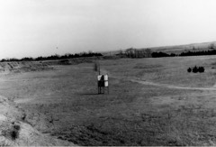 | Medicine Lodge Peace Treaty Site | site | 1969 | 69000059 |
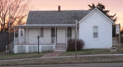 | Carry A. Nation House | building | 1971 | 71000303 |
Every wildfire the federal occurrence database records inside this county: 18 of them, burning about 63,091 acres. 1 started naturally and none was recorded as arson. Each settlement page carries the fires within five miles of it.
| Reported cause | Fires |
|---|---|
| Missing data/not specified/undetermined | 11 |
| Debris and open burning | 5 |
| Natural | 1 |
| Smoking | 1 |
The five largest, by the area the report gives. None of them was recorded as arson.
| Date | Cause | Size | Reported by | Name on the report |
|---|---|---|---|---|
| 4 August 2008 | Missing data/not specified/undetermined | 38,400 acres | Kansas Counties | BARBER COUNTY |
| 25 March 2020 | Missing data/not specified/undetermined | 5,500 acres | Barber County | EWB |
| 19 November 2007 | Missing data/not specified/undetermined | 5,000 acres | Kansas Counties | AETNA FIRE |
| 20 March 2008 | Missing data/not specified/undetermined | 4,250 acres | Kansas Counties | LAKE CITY |
| 28 January 2015 | Missing data/not specified/undetermined | 3,000 acres | Kansas Counties | HOPKINS |
| 14 April 2008 | Missing data/not specified/undetermined | 3,000 acres | Kansas Counties | LARKIN |
| 14 March 1994 | Missing data/not specified/undetermined | 2,000 acres | Barber County | not named |
| 22 March 1994 | Missing data/not specified/undetermined | 1,400 acres | Barber County | not named |
Every settlement page carries the fires within five miles of it - see the settlement index below.
The NOAA Storm Events Database holds 742 reports for this county, causing no deaths, 4 injuries and about $1,786,310 in recorded property damage. Each settlement page carries the reports that name it.
| Kind of event | Reports |
|---|---|
| Hail | 426 |
| Thunderstorm Wind | 215 |
| Tornado | 42 |
| Heavy Rain | 32 |
| Flood | 11 |
| Flash Flood | 9 |
| Funnel Cloud | 4 |
| Lightning | 3 |
The most serious of them, by death, then injury, then recorded damage. The accounts are quoted exactly as the forecast office filed them.
| When | Event | Place named | Harm | What the report says |
|---|---|---|---|---|
| April 1976 | Tornado (F4) | not stated | 2 hurt, $250,000 | no account filed |
| June 2017 | Thunderstorm Wind | Stubbs | 1 hurt | A semi truck was blown off the road by the high wind. The driver suffered non-life threatening head injuries but was taken to the hospital. |
| July 2009 | Lightning | (P28)Medicine Lodge | 1 hurt | A 14 year old male was struck and severely injured by a lightning bolt. He was going outside where some tents were pitch. CPR had to be performed as he had not pulse or respiration when rescuers reached him. Miraculously he made a full recovery after about 2 weeks in the hospital. |
| May 1998 | Thunderstorm Wind | Medicine Lodge | $500,000 | Rear Flank Downdraft caused extensive damage to roofs, trees, power lines and sheds. |
| June 2008 | Thunderstorm Wind | Hardtner | $360,000 | Trees were reported in town. The school gym was torn off and there was also damage to the local COOP. Damage extended out into the county. |
| June 1967 | Tornado (F2) | not stated | $250,000 | no account filed |
| May 2019 | Lightning | Medicine Lodge | $100,000 | A home was struck by lightning causing a fire. The resident received smoke inhalation was expired so this is an indirect death. |
| September 1998 | Thunderstorm Wind | Isabel | $100,000 | Microburst caused extensive damage to the Lake Arrowhead resort area. Several boat docks were destroyed. Part of a roof was taken off a cabin/house. A Garage under construction was completely destroyed. Damage was about 3 miles wide long starting near the resort and extending south and southwest. The length of the damage area was unknown due to range land extending beyond the resort. There were also six, very large-mature cottonwood trees uprooted with heavy damage to the remainder of the trees in the area. |
| May 1995 | Hail | Sawyer | $50,000 | no account filed |
| August 1986 | Tornado (F1) | not stated | $25,000 | no account filed |
| May 1964 | Tornado (F3) | not stated | $25,000 | no account filed |
| May 1959 | Tornado | not stated | $25,000 | no account filed |
| May 1999 | Thunderstorm Wind | Sharon | $20,000 | Barn damaged. |
| May 1999 | Lightning | Sharon | $20,000 | House struck. |
| September 1998 | Thunderstorm Wind | Medicine Lodge | $15,000 | Numerous trees were uprooted. |
| September 2009 | Flood | Sun City | $10,000 | A county road near Sun City was closed due to flooding. |
| September 2009 | Flood | Lake City | $10,000 | A local road was closes for a while due to flooding from the Medicine River. |
| May 2004 | Tornado (F1) | Kiowa | $10,000 | This tornado moved extremely slowly churning up red-plowed fields. One barn was destroyed. |
| May 2001 | Thunderstorm Wind | Kiowa | $5,000 | Ten to fifteen trees heavily damaged; part of the roof off a tin shed found 1/2 mile a way, along with 2 x 6's. |
| September 1998 | Thunderstorm Wind | Medicine Lodge | $5,000 | Large tree toppled by the high wind. |
| March 1976 | Tornado (F1) | not stated | $2,500 | no account filed |
| May 2002 | Thunderstorm Wind | Isabel | $1,000 | A house lost some trim due to high winds. |
| July 1998 | Thunderstorm Wind | Kiowa | $1,000 | Eight inch tree limbs blown down. |
| October 1998 | Thunderstorm Wind | Sun City | $1,000 | Six inch tree limb was blown down and a window blown out of a house. |
| July 1999 | Thunderstorm Wind | Hardtner | $500 | Power pole blown down. |
| June 1954 | Tornado (F0) | not stated | $250 | no account filed |
| May 1983 | Tornado (F0) | not stated | $30 | no account filed |
| September 1979 | Tornado (F0) | not stated | $30 | no account filed |
| March 2026 | Hail | Kiowa Arpt | - | A social media photo showed 1 inch hail. Additionally, the emergency manager reported 0.75 inch hail at the same time and place. |
| March 2026 | Hail | Sharon | - | A social media photo of 1.75 inch hail. |
| March 2026 | Hail | Uppdegraff | - | Report via social media of 1 inch hail. |
| March 2026 | Hail | (P28)Medicine Lodge | - | A member of broadcast media reported 1.5 inch hail. |
| March 2026 | Hail | Sharon | - | Social media report of 1.5 inch hail. |
| April 2026 | Thunderstorm Wind | Deerhead | - | A COOP observer reported a 70 mph wind gust. |
| September 2025 | Thunderstorm Wind | Lake Arrowhead | - | The emergency manager reported a 60 wind gust in Iuka. |
| September 2025 | Thunderstorm Wind | (P28)Medicine Lodge | - | The KP28 AWOS reported a 61 mph wind gust. |
| April 2025 | Hail | Aetna | - | Report of dime to quarter size hail, relayed via social media. |
| April 2025 | Hail | Medicine Lodge | - | Picture of golf ball size hail sent via social media. |
| April 2025 | Hail | (P28)Medicine Lodge | - | Barber County emergency manager sent a picture of gold ball size hail via Slack. |
| June 2025 | Thunderstorm Wind | Hardtner | - | A KZLF Transmitter Site recorded a wind gust of 64 mph. |
| June 2025 | Heavy Rain | Medicine Lodge | - | A cocorahs report indicated 2.60 inches of rain fell. |
| June 2025 | Heavy Rain | (P28)Medicine Lodge | - | A CoCoRaHs report indicated that 3.20 inches of rain fell overnight. |
| August 2025 | Thunderstorm Wind | Hardtner | - | The KZLF Transmitter Site recorded a 64 mph wind gust. |
| August 2025 | Thunderstorm Wind | Hardtner | - | The radio KZLF Transmitter Site recorded a 60 mph wind gust. |
| August 2025 | Thunderstorm Wind | Lake Arrowhead | - | Mesonet station DW9907 Bloom reported a 65 mph wind gust, Mesonet station UP835 3.0 W Kingsdown reported a 62 mph, and a AWN weather station reported a 60 mph in the same time and area. |
| May 2025 | Thunderstorm Wind | Hardtner | - | The KZLF Transmitter Site recorded a wind gust of 58 mph. |
| June 2024 | Thunderstorm Wind | Sun City | - | Large tree blown down as well as extensive tree damage across town. |
| June 2024 | Thunderstorm Wind | (P28)Medicine Lodge | - | A wind report of 58 mph. |
| May 2024 | Thunderstorm Wind | Hazelton | - | Wind gust of 58 mph. |
| June 2024 | Heavy Rain | Medicine Lodge | - | Rainfall report of 3.35 inches. |
| June 2024 | Heavy Rain | Lake City | - | Rainfall report of 2.65 inches. |
| June 2024 | Heavy Rain | Lake City | - | Rainfall report of 2.61 inches. |
| July 2024 | Thunderstorm Wind | (P28)Medicine Lodge | - | Measured at Medicine Lodge Airport. |
| September 2024 | Thunderstorm Wind | Hardtner | - | Mesonet site (KZLF transmitter) recorded a wind gust of 62 MPH. |
| October 2024 | Hail | Medicine Lodge | - | Hail with diameters ranging from quarter size to golf ball size was reported by law enforcement. |
| August 2024 | Hail | Medicine Lodge | - | Hail the size of quarters was reported by the public. |
| August 2024 | Hail | Deerhead | - | The hail report was observed and estimated by a trained spotter. |
| May 2024 | Tornado (EF0) | Hazelton | - | EF0 tornado developed in Hazelton and went NE 1 mile. |
| June 2024 | Thunderstorm Wind | (P28)Medicine Lodge | - | A 60 mph wind gust reported. |
| May 2023 | Flash Flood | Hazelton | - | Water running over the road in the vicinity of Tri City Road. Radar estemated 4 to 5 inches of rain in the area. |
The Survey's mineral resources record lists 3 workings inside this county. All of them still produce. Each settlement page carries the workings within five miles of it.
| Commodity | Workings |
|---|---|
| Gypsum-Anhydrite | 3 |
The least common of them first, because a county's hundredth gravel pit says nothing its first ten did not.
| Where | Site | Commodity | Status | Recorded |
|---|---|---|---|---|
| Medicine Lodge Plant | Gypsum-Anhydrite | Producer | ||
| National Gypsum Mine,Quarry,Crusher | Gypsum-Anhydrite | Producer | ||
| Sun City Mine & Mill | Gypsum-Anhydrite | Producer |
Named settlements recorded in the Geographic Names Information System, each with the topographic sheets covering it. Villages, hamlets and abandoned places alike. Each is shown with the nearest named watercourse or landform and the survey quadrangle it falls on.
Elm Mills township · 67134 · On North Elm Creek · Sawyer quadrangle
14 sheets, 1891 to 1985
Mingona township · 67104 · On Bitter Creek · Medicine Lodge SW quadrangle
14 sheets, 1891 to 1985
Lake City township · 67071 · On Puckett Creek · Lake City quadrangle
14 sheets, 1891 to 1985
Medicine Lodge township · 67104 · On Elm Creek · Medicine Lodge quadrangle
14 sheets, 1891 to 1985
Sharon township · 67138 · On East Branch Little Sandy Creek · Sharon South quadrangle
15 sheets, 1889 to 1985