 Block
From the record
5 National Register listings published here.
Sources: the National Register database, National Park Service
30 topographic sheets cover 13 settlements here, and 5 properties are on the National Register of Historic Places.
5 National Register listings published here.
Sources: the National Register database, National Park Service
Every property in this county listed on the National Register of Historic Places, with the year it was listed and the federal nomination document.
| Photograph | Property | Type | Listed | Reference |
|---|---|---|---|---|
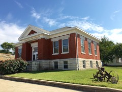 | Burlington Carnegie Free Library | building | 1987 | 87000934 |
 | Cleo F. Miller House | building | 1991 | 91001897 |
 | Neosho River Bridge | structure | 1983 | 83000420 |
 | Plaza Theater | building | 2005 | 05000005 |
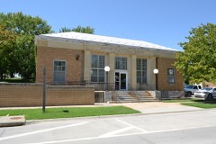 | US Post Office-Burlington | building | 1989 | 89001634 |
Every wildfire the federal occurrence database records inside this county: 348 of them, burning about 25,107 acres. 1 started naturally and 31 were recorded as arson. Each settlement page carries the fires within five miles of it.
| Reported cause | Fires |
|---|---|
| Debris and open burning | 175 |
| Missing data/not specified/undetermined | 111 |
| Arson/incendiarism | 31 |
| Smoking | 18 |
| Equipment and vehicle use | 9 |
| Recreation and ceremony | 2 |
| Fireworks | 1 |
| Natural | 1 |
The five largest, by the area the report gives. None of them was recorded as arson.
| Date | Cause | Size | Reported by | Name on the report |
|---|---|---|---|---|
| 21 April 2008 | Debris and open burning | 1,188 acres | Flint Hills National Wildlife Refuge | KENNEDY CREEK EAST |
| 2 April 2019 | Missing data/not specified/undetermined | 1,120 acres | Flint Hills National Wildlife Refuge | EAST KENNEDY CREEK |
| 6 April 2011 | Missing data/not specified/undetermined | 1,078 acres | Flint Hills National Wildlife Refuge | EAST KENNEDY CREEK |
| 8 April 2009 | Debris and open burning | 1,043 acres | Flint Hills National Wildlife Refuge | KENNEDY CREEK EAST |
| 14 April 2020 | Missing data/not specified/undetermined | 914 acres | Flint Hills National Wildlife Refuge | EAST KENNEDY CREEK |
| 2 May 1999 | Debris and open burning | 885 acres | Flint Hills National Wildlife Refuge | W KENNEDY |
| 9 May 2000 | Debris and open burning | 832 acres | Flint Hills National Wildlife Refuge | WILLIAMSON |
| 12 April 2010 | Missing data/not specified/undetermined | 775 acres | Flint Hills National Wildlife Refuge | EAST KENNEDY CREEK |
Every settlement page carries the fires within five miles of it - see the settlement index below.
The NOAA Storm Events Database holds 504 reports for this county, causing 2 deaths, 26 injuries and about $6,594,180 in recorded property damage. Each settlement page carries the reports that name it.
| Kind of event | Reports |
|---|---|
| Hail | 242 |
| Thunderstorm Wind | 184 |
| Flash Flood | 33 |
| Tornado | 26 |
| Lightning | 7 |
| Flood | 6 |
| Funnel Cloud | 4 |
| Heavy Rain | 2 |
The most serious of them, by death, then injury, then recorded damage. The accounts are quoted exactly as the forecast office filed them.
| When | Event | Place named | Harm | What the report says |
|---|---|---|---|---|
| July 2012 | Lightning | Waverly | 1 killed | A Kansas man died after being struck by a bolt of lightning. It happened just after 8:15 p.m. Saturday in Coffey County near Waverly.||Coffey County officials say Ronald Nicholas, 68, was outside in his front yard when he was hit. He was hosting a family gathering to celebrate the Fourth of July when the accident happened.||Officials say the storm was not directly over Nicholas' home. He was killed by a stray bolt of lightning from a nearby storm. |
| September 2011 | Lightning | Burlington Arpt | 1 killed | The Emporia Gazette reported that Patty Gilliam, a Spanish teacher from Emporia High School died on Wednesday, September 14, 2011 from injuries sustained from a lightning strike that occurred on Saturday September 10, 2011. She was riding her bicycle across John Redmond Dam when she was struck by lightning which was produced from passing thunderstorms. She was listed as 48 years old. |
| August 1986 | Hail | not stated | 18 hurt | no account filed |
| April 1956 | Tornado (F4) | not stated | 5 hurt, $25,000 | no account filed |
| August 1984 | Thunderstorm Wind | not stated | 3 hurt | no account filed |
| October 1992 | Tornado (F1) | not stated | $2,500,000 | no account filed |
| November 1998 | Flash Flood | Burlington | $1,000,000 | no account filed |
| April 1996 | Hail | Le Roy | $1,000,000 | no account filed |
| June 2007 | Flood | Le Roy | $300,000 | With heavy rain and thunderstorms, the Neosho River reaches a moderate flood stage and continues to flood with intermittent heavy rains continuing through the end of the month. By the morning of the 30th, some major highways are flooded. By the evening of the 30th, Leroy is landlocked by flooded roads. Flooding continues into July. |
| May 1983 | Tornado (F1) | not stated | $250,000 | no account filed |
| November 1973 | Tornado (F2) | not stated | $250,000 | no account filed |
| December 2008 | Thunderstorm Wind | Ottumwa | $230,000 | Several reports of damage from New Strawn. The Southern Coffey County Middle School had a portion of it's roof torn off. All 24 doors at Bahr Storage were blown off. A barn and a grain bin also sustained damage. |
| June 2025 | Flash Flood | Burlington | $100,000 | Storm Spotter in Burlington reports that Rock Creek is overflowing into several homes. |
| June 2007 | Flash Flood | Burlington | $100,000 | Numerous roads under water in Burlington and from Burlington to Waverly. |
| July 2007 | Flood | Le Roy | $100,000 | Flooding continues into early July. A number of roads continue under water. A state report indicated that one house in the county received major damage, four had minor damage and 16 houses were affected. |
| July 1996 | Lightning | Halls Summit | $80,000 | no account filed |
| May 2004 | Lightning | Burlington | $63,000 | Lightning struck a house and ignited a fire that destroyed most of the house and its contents. |
| June 2007 | Flash Flood | Halls Summit | $60,000 | Sheriff reports a swift current of water flowing over 23rd rd. between US 75 and Kafir rd. Water was flowing fast enough that officer did not want to try and cross the road...at least 4 inches deep. |
| June 2007 | Flash Flood | Waverly | $50,000 | Water reported flowing 6 to 10 inches deep over bridge on highway 31. Fast flowing water at least 4 inches deep over highway 81. Fast flowing water at least 4 inches deep over 17th and Plantar road. |
| June 2007 | Flash Flood | Burlington | $50,000 | Water two feet deep was flowing across 12th road between Wayside and Shetland. Also, 16th and 17th Rd. between Reaper and Quail is flooded. |
| May 2007 | Heavy Rain | Lebo | $50,000 | Three to three and a half inches of rain fell during the morning hours. This rain falling on saturated soils brought some small steam flooding along with street flooding in and around Lebo. |
| June 2007 | Flash Flood | Burlington | $40,000 | Several gravel roads in the county with water flowing over them at least 6 inches deep. Every unpaved road southeast of Burlington has at least some water running over them. |
| June 2007 | Flood | Burlington | $40,000 | The intersection of 12th and Shetland road and the intersection of 16th and Quail road were both water covered and impassable. Reports of up to 4.5 inches of rain. |
| March 2004 | Flash Flood | Burlington | $25,000 | no account filed |
| October 1998 | Flash Flood | Burlington | $25,000 | no account filed |
| May 1982 | Tornado (F0) | not stated | $25,000 | no account filed |
| May 1982 | Tornado (F0) | not stated | $25,000 | no account filed |
| May 1964 | Tornado (F2) | not stated | $25,000 | no account filed |
| July 1954 | Tornado | not stated | $25,000 | no account filed |
| April 1950 | Tornado (F1) | not stated | $25,000 | no account filed |
| May 2004 | Lightning | Burlington | $15,000 | Lightning struck a house in Burlington and started a fire that did considerable damage to the house. |
| July 2003 | Hail | Waverly | $15,000 | Large hail damaged a few car windows as well as some roof and window damage on a few homes in the Waverly area. |
| June 2007 | Flash Flood | Burlington | $10,000 | Spotter report that one foot of water was flowing over Xeric Road, outside of the city of Burlington. Several hours later, around 11am CST, one to two feet of water continued to flow over county and gravel roads to the east of Burlington. A bit earlier, at 7:14 am CST, water was reported to be running over 22nd Road. At 7:34 CST, Emmer Road between 24th and 25th Streets water covered and impassible. |
| May 2004 | Thunderstorm Wind | Le Roy | $10,000 | Strong thunderstorm winds damaged farm buildings and equipment near LeRoy. |
| April 2003 | Thunderstorm Wind | Burlington | $10,000 | Strong winds tore apart a metal storage building with parts of it striking electric lines and a pickup truck doing extensive damage to the truck. Brick signs at 2 schools were also blown over. |
| July 1996 | Thunderstorm Wind | Lebo | $10,000 | no account filed |
| July 2011 | Thunderstorm Wind | Halls Summit | $8,000 | Five power poles were destroyed on the west side of U.S. Highway 75. |
| July 1996 | Thunderstorm Wind | Waverly | $8,000 | no account filed |
| May 2006 | Flash Flood | Waverly | $5,000 | Heavy thunderstorm rains caused several inches of flowing water across roads in Waverly. Officials also reported 6 to 8 inches of flowing water over roads in northwest parts of Coffey County. |
| July 1994 | Thunderstorm Wind | Burlington | $5,000 | A Dericho wind storm moved northwest to southeast across northeast and central Kansas producing winds of 50 to 100 mph. The high winds caused widespread and significant damage to nearly every county. Numerous power lines were knocked down, trees uprooted with buildings and roofs damaged or destroyed. The most severe damage and highest winds appeared to occur in a line from near Marysville to Westmoreland/Emmett to Topeka to Lawrence. It was likely the worst "straight line" and most widespread wind storm in at least ten years. The local electrical utility, Kansas Power and Light, estimated damages to their system at $10 to $15 million. |
| April 1993 | Hail | Burlington | $5,000 | Soft hail about the size of golfballs accumulated to a couple of inches. No major damage was reported. However locally heavy rainfall caused temporary flooding of low lying and poor drainage areas. |
| February 2012 | Thunderstorm Wind | Le Roy | $3,000 | This was a delayed report from a resident near Le Roy, Kansas. A couple outbuildings were destroyed and a barn had its roof peeled off in the thunderstorm winds. |
| August 2010 | Thunderstorm Wind | Sharpe | $3,000 | Power lines and poles were down along Highway 75 near Coffey County Airport. Time was estimated with radar. |
| May 1999 | Lightning | Burlington | $3,000 | Lightning struck a residence doing an estimated 3 thousand dollars damage to the chimney, roof and electrical appliances. |
| May 1983 | Tornado (F0) | not stated | $2,500 | no account filed |
| May 1982 | Tornado (F0) | not stated | $2,500 | no account filed |
| September 1955 | Tornado (F2) | not stated | $2,500 | no account filed |
| April 1954 | Tornado (F2) | not stated | $2,500 | no account filed |
| August 2000 | Lightning | Burlington | $2,000 | Lightning struck a house and ignited a fire that caused minor damage. |
| June 2025 | Flash Flood | Burlington | $1,000 | High water covering roadways in west Burlington. |
| April 2014 | Thunderstorm Wind | Gridley | $1,000 | Limbs around 4 to 6 inch down near gridley. delayed report. Time estimated from radar. |
| June 2009 | Thunderstorm Wind | Sharpe | $1,000 | A 4 inch tree limb was broken due to strong winds with a thunderstorm. |
| April 2008 | Thunderstorm Wind | Burlington | $1,000 | A wind gust blew a tractor trailer onto it's side. Highway 75 was partially blocked by the trailer. |
| May 2002 | Thunderstorm Wind | Waverly | $1,000 | Strong winds blew out windows. |
| June 2025 | Flash Flood | Burlington | $500 | Ditches, yards, and several roads full of water. |
| June 2025 | Flash Flood | Burlington | $500 | Street flooding occurring in Burlington. |
| September 2012 | Thunderstorm Wind | Burlington | $500 | A 6 inch diameter tree branch fell as a result of thunderstorm winds in Burlington. |
| June 2011 | Thunderstorm Wind | Sharpe | $500 | Two to three inch diameter tree limbs were broken. |
| June 2011 | Thunderstorm Wind | Gridley | $500 | A member of the public reported two inch tree limbs broken. |
| July 1996 | Thunderstorm Wind | Burlington | $500 | no account filed |
The Survey's mineral resources record lists 7 workings inside this county. 6 still produce and 1 is closed or unrecorded. Each settlement page carries the workings within five miles of it.
| Commodity | Workings |
|---|---|
| Stone, Crushed/Broken | 5 |
| Stone | 1 |
| Sand and Gravel, Construction | 1 |
The least common of them first, because a county's hundredth gravel pit says nothing its first ten did not.
| Where | Site | Commodity | Status | Recorded |
|---|---|---|---|---|
| Arrowhead Sand Plant | Sand and Gravel, Construction | Producer | ||
| B&H Rock Company Quarry | Stone | Unknown | ||
| Davies Quarry | Stone, Crushed/Broken | Producer | ||
| Jones Quarry | Stone, Crushed/Broken | Producer | ||
| Sharp Quarry & Mill | Stone, Crushed/Broken | Producer | ||
| Venture Quarry No. 5 | Stone, Crushed/Broken | Producer | ||
| Wuerfele Quarry & Mill | Stone, Crushed/Broken | Producer |
Named settlements recorded in the Geographic Names Information System, each with the topographic sheets covering it. Villages, hamlets and abandoned places alike. Each is shown with the nearest named watercourse or landform and the survey quadrangle it falls on.
Key West township · 66871 · On Sand Creek · Waverly NW quadrangle
18 sheets, 1885 to 1990
Pleasant township · 66854 · On Jacobs Creek · Ottumwa quadrangle
16 sheets, 1885 to 1990
Ottumwa township · 66839 · On West Hickory Creek · Ottumwa quadrangle
16 sheets, 1885 to 1990