 Block
From the record
5 National Register listings published here.
Sources: the National Register database, National Park Service
55 topographic sheets cover 10 settlements here, and 5 properties are on the National Register of Historic Places.
5 National Register listings published here.
Sources: the National Register database, National Park Service
Every property in this county listed on the National Register of Historic Places, with the year it was listed and the federal nomination document.
| Photograph | Property | Type | Listed | Reference |
|---|---|---|---|---|
| Elk County Courthouse | building | 2009 | 09000227 | |
| Elk Falls High School Gymnasium | building | 2024 | 100009705 | |
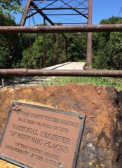 | Elk Falls Pratt Truss Bridge | structure | 1994 | 94000403 |
| Grenola Mill and Elevator | building | 2002 | 02000764 | |
| Howard National Bank | building | 2020 | 100005948 |
Every wildfire the federal occurrence database records inside this county: 183 of them, burning about 38,369 acres. 1 started naturally and 31 were recorded as arson. Each settlement page carries the fires within five miles of it.
| Reported cause | Fires |
|---|---|
| Missing data/not specified/undetermined | 75 |
| Debris and open burning | 61 |
| Arson/incendiarism | 31 |
| Equipment and vehicle use | 9 |
| Smoking | 4 |
| Other causes | 1 |
| Natural | 1 |
| Recreation and ceremony | 1 |
The five largest, by the area the report gives. Three of them were set deliberately.
| Date | Cause | Size | Reported by | Name on the report |
|---|---|---|---|---|
| 11 April 1996 | Missing data/not specified/undetermined | 12,000 acres | Elk County | not named |
| 12 February 2015 | Missing data/not specified/undetermined | 3,500 acres | Greenwood County | LILLIAM RANCH |
| 21 March 2015 | Arson/incendiarism | 2,000 acres | Kansas Forest Service | 1500031 |
| 20 March 2017 | Arson/incendiarism | 1,800 acres | Elk County | 17039 |
| 3 March 2017 | Arson/incendiarism | 1,500 acres | Elk County | 17023 |
| 14 April 1998 | Missing data/not specified/undetermined | 850 acres | Elk County | not named |
| 17 March 2016 | Missing data/not specified/undetermined | 800 acres | Kansas Forest Service | 1600045 |
| 17 April 2018 | Missing data/not specified/undetermined | 800 acres | Kansas Forest Service | 18047 |
Every settlement page carries the fires within five miles of it - see the settlement index below.
The NOAA Storm Events Database holds 345 reports for this county, causing 2 deaths, 8 injuries and about $30,582,830 in recorded property damage. Each settlement page carries the reports that name it.
| Kind of event | Reports |
|---|---|
| Hail | 159 |
| Thunderstorm Wind | 88 |
| Tornado | 31 |
| Heavy Rain | 26 |
| Flash Flood | 24 |
| Flood | 12 |
| Funnel Cloud | 4 |
| Lightning | 1 |
The most serious of them, by death, then injury, then recorded damage. The accounts are quoted exactly as the forecast office filed them.
| When | Event | Place named | Harm | What the report says |
|---|---|---|---|---|
| April 1956 | Tornado (F4) | not stated | 1 killed, 6 hurt, $2,500,000 | no account filed |
| April 1991 | Tornado (F3) | not stated | 1 killed, 2 hurt, $250,000 | no account filed |
| July 2007 | Flash Flood | Howard | $27,000,000 | Extremely heavy rainfall from the end of June into early July caused flash flooding throughout Elk County. The flooding damaged or destroyed around 400 houses. This led 12 to 42 million dollars in damage. An awesome 21.49 inches of rain fell during the month of June. Much of this fell during the last few days of the month. |
| October 1982 | Tornado (F1) | not stated | $250,000 | no account filed |
| May 2009 | Thunderstorm Wind | Longton | $180,000 | An estimated 80 mph winds knocked down 6 barns, and broke several trees. |
| April 2015 | Thunderstorm Wind | Moline | $50,000 | Damage was reported to buildings and homes, including windows blown out. One mobile home was also damaged. |
| August 2013 | Thunderstorm Wind | Howard | $50,000 | Numerous trees were knocked down across town. |
| June 2001 | Lightning | Howard | $50,000 | The northwest roof of Elk County Courthouse was struck, inflicting damage to the roof tile, the elevator, and several computers. A second lightning strike set fire to a hay barn. The barn was a total loss. |
| April 2010 | Thunderstorm Wind | Howard | $35,000 | A pole barn with dimensions of 40 feet by 60 feet was completely destroyed. Additionally, some minor shed and house damage occurred. Ten inch tree limbs were blown down as well. |
| June 2008 | Thunderstorm Wind | Howard | $27,000 | High winds knocked out power to Howard. |
| May 2005 | Hail | Moline | $25,000 | Unspecified number of vehicles damaged with windows broken out of homes, businesses and vehicles. (Narrative courtesy of Independence Daily Reporter.) |
| April 1984 | Tornado (F1) | not stated | $25,000 | no account filed |
| November 1960 | Tornado (F2) | not stated | $25,000 | no account filed |
| November 1958 | Tornado | not stated | $25,000 | no account filed |
| July 1996 | Thunderstorm Wind | Howard | $12,000 | no account filed |
| June 1999 | Thunderstorm Wind | Grenola | $10,000 | Transformers blown out. |
| May 2018 | Thunderstorm Wind | Longton | $8,000 | The destructive winds tore off part of a roof from a home. |
| January 2008 | Thunderstorm Wind | Elk Falls | $7,500 | A trained spotter reported that thunderstorm winds downed a powerline south of Elk Falls. |
| September 2019 | Tornado (EF1) | Longton | $5,000 | There was some roof damage to a home and an outbuilding was shifted from its foundation. There was also some damage to chicken coops. The time of the event was estimated. |
| May 2016 | Thunderstorm Wind | Grenola | $5,000 | Reports of 4 to 6 inch diameter branches being blown out of trees. |
| May 1993 | Thunderstorm Wind | Moline | $5,000 | no account filed |
| May 1993 | Thunderstorm Wind | Elk Falls | $5,000 | no account filed |
| April 2010 | Thunderstorm Wind | Howard | $3,000 | Estimated 70 mph winds damaged a fence and a sheet metal shed. |
| July 1996 | Thunderstorm Wind | Moline | $3,000 | no account filed |
| April 1996 | Thunderstorm Wind | Grenola | $3,000 | no account filed |
| April 1960 | Tornado (F1) | not stated | $2,500 | no account filed |
| June 1959 | Tornado (F2) | not stated | $2,500 | no account filed |
| May 1957 | Tornado | not stated | $2,500 | no account filed |
| May 1957 | Tornado | not stated | $2,500 | no account filed |
| May 1957 | Tornado | not stated | $2,500 | no account filed |
| May 1957 | Tornado | not stated | $2,500 | no account filed |
| April 2010 | Thunderstorm Wind | Howard | $2,250 | Estimated 70 mph winds damaged a tree and damaged a barn roof. |
| June 2014 | Thunderstorm Wind | Grenola | $2,000 | A 30 foot tree was uprooted. |
| March 2015 | Hail | Elk Falls | $1,000 | The report was received from a ham operator. The hail caused dents on a car roof. |
| May 2009 | Flood | Longton | $500 | Water was covering Highway 160 east to Oak Valley Road. |
| July 1994 | Thunderstorm Wind | Grenola | $500 | A cattle truck was blown over four miles west of town and there were fallen trees in town. |
| May 1993 | Hail | Howard | $500 | A thunderstorm dropped three-quarter inch hail around Howard. |
| April 1994 | Hail | Moline | $500 | no account filed |
| April 1994 | Hail | Moline | $500 | no account filed |
| February 1993 | Hail | Grenola | $500 | no account filed |
| May 1993 | Hail | Howard | $500 | no account filed |
| July 2010 | Thunderstorm Wind | Howard | $100 | Winds estimated at 50 to 60 mph downed some small tree limbs as well as damaged a screen door. |
| July 2010 | Flash Flood | Longton | $100 | Heavy rainfall of 5 to 6 inches closed portions of Highway 160 from Grenola to Longton. The town of Howard reported 4.70 inches of rainfall. The worse flooding along Highway 160 was near Oak Valley. |
| July 2010 | Flash Flood | Longton | $100 | Numerous rural roads were flooded over the eastern half of the county. Highway 160 was closed near Oak Valley. |
| August 2009 | Thunderstorm Wind | Longton | $100 | Tree limbs were downed by the strong winds. |
| June 2008 | Flood | Howard | $100 | Heavy rainfall produced 4.30 inches of rain with agriculture flooding and some minor road flooding. |
| April 1994 | Hail | Howard | $50 | no account filed |
| May 1957 | Tornado | not stated | $30 | no account filed |
| July 2025 | Thunderstorm Wind | Howard | - | Several trees and large tree limbs were reported down corroborated from two different CO-OP observers that there was widespread tree damage across Howard. Time was estimated from radar. |
| July 2025 | Thunderstorm Wind | Longton | - | Wind gusts were estimated to be around 60 mph. |
| June 2025 | Thunderstorm Wind | Howard | - | The KSU mesonet measured a 62 mph wind gust. |
| April 2024 | Tornado (EF0) | Longton | - | Law enforcement officer sent in pictures of tree damage that occurred in eastern Elk County. |
| February 2024 | Heavy Rain | Longton | - | This is a 24 hour rainfall total of 1.44 inches. |
| May 2024 | Heavy Rain | Longton | - | Twenty four hour rainfall from COOP observer of 2.46 inches. This heavy rain resulted in some flooding of Highway 160 on the west side of town. |
| May 2024 | Heavy Rain | Howard | - | Twenty four hour rainfall from CoCoRaHS observer of 2.05 inches. Street flooding occurred in town during the late evening hours of the 6th. |
| May 2024 | Flood | Moline | - | Portions of US Highway 160 flooded between the town of Elk Falls and Dove Road, east of Moline. |
| May 2024 | Heavy Rain | Grenola | - | Twenty four hour rainfall total from CoCoRahs observer of 2.18 inches. |
| April 2024 | Tornado (EF1) | Moline | - | A couple of hardwood trees fell onto a car near a vacant house. Minimal if any damage occurred to the nearby home. A shed across the road had some tin peeled up on it, but it has open sides. A smaller tree down the road, to the north, had its trunk snapped. There was damage to a power pole and broken branches off a tree at the end of the path. |
| April 2024 | Tornado (EFU) | Moline | - | A multi-vortex brief tornado just south of Moline and secondary to the main rotation off to the north. No damage occurred. |
| April 2024 | Tornado (EFU) | Elk Falls | - | A tornado was reported by law enforcement likely between Elk Falls and Longton. No damage occurred. |
Named settlements recorded in the Geographic Names Information System, each with the topographic sheets covering it. Villages, hamlets and abandoned places alike. Each is shown with the nearest named watercourse or landform and the survey quadrangle it falls on.
Elk Falls township · 67345 · On Wildcat Creek · Elk Falls quadrangle
13 sheets, 1885 to 1985
Wildcat township · 67353 · On North Fork Wildcat Creek · Moline quadrangle
13 sheets, 1885 to 1985
Oak Valley township · 67344 · On Bloody Run · Oak Valley quadrangle
13 sheets, 1885 to 1985