 Block
From the record
3 National Register listings published here, 1 of them a National Historic Landmark.
Sources: the National Register database, National Park Service
27 topographic sheets cover 9 settlements here, and 3 properties are on the National Register of Historic Places.
3 National Register listings published here, 1 of them a National Historic Landmark.
Sources: the National Register database, National Park Service
Every property in this county listed on the National Register of Historic Places, with the year it was listed and the federal nomination document.
| Photograph | Property | Type | Listed | Reference |
|---|---|---|---|---|
| Antelope Lake Park | district | 2008 | 08000643 | |
 | Harry Keith Barn | building | 2013 | 13000149 |
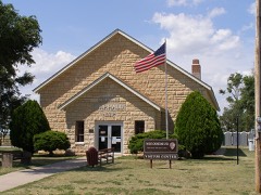 | Nicodemus Historic District; Nicodemus National Historic Site | district | 1976 | 76000820 |
Every wildfire the federal occurrence database records inside this county: 21 of them, burning about 12,363 acres. None started naturally and 1 was recorded as arson. Each settlement page carries the fires within five miles of it.
| Reported cause | Fires |
|---|---|
| Missing data/not specified/undetermined | 13 |
| Other causes | 3 |
| Equipment and vehicle use | 2 |
| Fireworks | 1 |
| Arson/incendiarism | 1 |
| Smoking | 1 |
The five largest, by the area the report gives. None of them was recorded as arson.
| Date | Cause | Size | Reported by | Name on the report |
|---|---|---|---|---|
| 5 March 2012 | Missing data/not specified/undetermined | 8,000 acres | Kansas Counties | KDOT |
| 2 December 1993 | Missing data/not specified/undetermined | 1,600 acres | Graham County | not named |
| 12 October 1995 | Missing data/not specified/undetermined | 1,200 acres | Graham County | not named |
| 11 March 2015 | Missing data/not specified/undetermined | 765 acres | Kansas Forest Service | 015-004 |
| 15 March 2015 | Missing data/not specified/undetermined | 483 acres | Kansas Forest Service | 015-005 |
| 18 October 2015 | Other causes | 251 acres | Kansas Forest Service | 015-018 |
| 12 October 2015 | Equipment and vehicle use | 25 acres | Kansas Forest Service | 015-016 |
| 3 August 2015 | Missing data/not specified/undetermined | 10 acres | Kansas Forest Service | 015-012 |
Every settlement page carries the fires within five miles of it - see the settlement index below.
The NOAA Storm Events Database holds 696 reports for this county, causing no deaths, 1 injury and about $10,464,930 in recorded property damage. Each settlement page carries the reports that name it.
| Kind of event | Reports |
|---|---|
| Hail | 358 |
| Thunderstorm Wind | 267 |
| Tornado | 41 |
| Flash Flood | 22 |
| Flood | 5 |
| Funnel Cloud | 1 |
| Dust Storm | 1 |
| Lightning | 1 |
The most serious of them, by death, then injury, then recorded damage. The accounts are quoted exactly as the forecast office filed them.
| When | Event | Place named | Harm | What the report says |
|---|---|---|---|---|
| June 1987 | Thunderstorm Wind | not stated | 1 hurt | no account filed |
| June 2011 | Tornado (EF3) | (Hlc)Hill City Muni | $5,000,000 | A strong tornado developed just west of U.S. Highway 283 north of Hill City and moved northeast into southern Norton County. The tornado produced extensive damage, including irrigation pivots overturned, utility poles destroyed, and farm implements rolled/tossed nearly 3/4 of a mile. The worst damage occurred in northern Graham County just east of Highway 283. Storm chasers reported at least one satellite tornado rotating around this main tornadic circulation. |
| June 1979 | Tornado (F1) | not stated | $2,500,000 | no account filed |
| June 2018 | Flash Flood | Hill City | $500,000 | The flood waters moved into Hill City from the north, overwhelming the drainage tunnels under the town. Water was deep enough in town to move into businesses. |Residents in the trailer park on the south side of town had to evacuate. Two different families had to be water rescued due to their resistance to leave despite flood waters surrounding their home in both instances. One trailer house was carried away by the flood waters. A house in town, located near where the drainage tunnels empty, was engulfed with flood waters. The city park and playground equipment, where the drainage for town empties, was almost completely submerged in water. Over six inches of rainfall was measured in town. |
| June 2011 | Tornado (EF1) | (Hlc)Hill City Muni | $500,000 | NWS employee and storm chaser indicated a satellite tornado north and northwest of the main tornado at approximately this time. |
| June 2011 | Tornado (EF1) | (Hlc)Hill City Muni | $500,000 | NWS employee and storm chaser reported a satellite tornado just east of Highway 283 in extreme northern Graham County. |
| April 1979 | Tornado (F2) | not stated | $250,000 | no account filed |
| August 2019 | Thunderstorm Wind | Morland | $150,000 | An NWS storm survey confirms wind damage consistent with winds of 90 to 105 mph. Several farmsteads lost buildings, trees, power poles, pivots, fences, and roofing material. A few grain bins were blown over. |
| May 2012 | Thunderstorm Wind | Morland | $126,000 | Strong thunderstorm outflow winds produced a swath of damage across northern Graham County. Winds estimated at 90 mph broke approximately 55 utility poles from Roads 130 and V, northeast to Roads 250 and CC. In addition, six irrigation pivots were overturned, two outbuildings were damaged or destroyed and numerous tree limbs broken. Time of events is estimated from radar and local residents. |
| May 2024 | Thunderstorm Wind | Bogue | $100,000 | Exceptional damage to a 60'x100' metal building with 15' side walls that was built in 2019. East wall was blown in, roof blown away, and substructure partially collapsed with metal siding peeled away. Several 2x4 planks of wood were stuck in the ground about 70' from the building near a broken telephone pole. Property owners found debris scattered about two miles to the southeast. |
| May 2018 | Flash Flood | Hill City | $100,000 | Flood waters were so deep water rescues had to be performed at a trailer park south of the river next to Highway 283 from 5:30 PM CDT to 11 PM CDT. Highway 283 was closed from Hill City to Wakeeney due to flood waters over the Highway on the south side of Hill City near the trailer park. The flooding extended thee miles south-southwest from town along the creek channel. |
| May 2018 | Flash Flood | Bogue | $100,000 | Highway 18 from Bogue to Damar was closed due to flooding. The flooding most likely occurred west of Sand Creek. Four farmhouses were flooded and 20 cattle drowned where Sand Creek and the South Fork of Solomon River meet. |
| July 2013 | Thunderstorm Wind | Studley | $90,000 | Reports were received from spotters, the public and law enforcement. Damage included a roof blown off a grainery, metal feeders damaged, power poles and lines down, large trees uprooted and large limbs broken, a center picot overturned and minor roof damage near Morland. Damage occurred from approximately 6 NW of Morland southeast to Morland. |
| May 2024 | Thunderstorm Wind | (Hlc)Hill City Muni | $50,000 | Metal garage had overhead doors blown out and folded with portions of the side wall torn away. |
| August 1997 | Thunderstorm Wind | Hill City Arpt | $50,000 | Wind gust recorded by ASOS. Damage in Hill City included windows blown out, power poles down, old barn destroyed, signs and tree branches down, and 1 roof off. |
| November 2015 | Thunderstorm Wind | Hill City | $35,000 | The roof was blown off the power plant for Hill City, causing the town to lose power. A shed was blown off its foundation and landed on a car. Numerous tree limbs were broken off. Damage was primarily confined to the southeast portion of town. |
| July 2020 | Thunderstorm Wind | Hill City | $30,700 | Law enforcement reported numerous live tree limbs and power lines down causing power outages. Four tank batteries for oil were blown over and an additional oil battery south of Hill City caught on fire. A power pole was also knocked down. The Hill City ASOS observed a 93 mph wind gust at the time the damage occurred. |
| May 2017 | Thunderstorm Wind | Morland | $30,000 | An empty grain bin was blown off its foundation and into the middle of the road. |
| June 1970 | Tornado (F2) | not stated | $25,000 | no account filed |
| May 1960 | Tornado (F1) | not stated | $25,000 | no account filed |
| May 1959 | Tornado (F2) | not stated | $25,000 | no account filed |
| June 1953 | Tornado (F0) | not stated | $25,000 | no account filed |
| June 1953 | Tornado (F1) | not stated | $25,000 | no account filed |
| June 1953 | Tornado (F2) | not stated | $25,000 | no account filed |
| July 2016 | Thunderstorm Wind | Morland | $20,000 | Two power poles were blown down causing Morland to lose power. A window in a house was broken in town from the combined effects of hail and very strong winds. |
| May 2016 | Flash Flood | St Peter | $16,000 | Several hours of repeated moderate to heavy rainfall in the St. Peter area led to flash flooding. Some of the culverts along county roads E and 120th Avenue where the North Fork of the Saline River crossed under the roads were washed out. A farm 1.5 NW of St. Peter reported more water in the yard than ever remembered in recent years. A rainfall total of seven and a half inches was measured near St. Peter. Other than the washed out culverts no other damage was reported. |
| April 2022 | Thunderstorm Wind | Morland | $15,000 | Straight-line winds snapped a number of power poles and damaged a small barn. |
| June 2020 | Thunderstorm Wind | St Peter | $15,000 | Pictures received of 4 power poles snapped or blown down due to strong thunderstorm winds. Time is radar estimated and speed is estimated by storm damage. |
| August 2010 | Thunderstorm Wind | Morland | $15,000 | Several trees blown over, roof damage and several trailer homes damaged in town. |
| May 2008 | Tornado (EF1) | Studley | $15,000 | One half mile of power poles were broken on an E-W section road northwest of Morland. Time of tornado development and dissipation estimated from Doppler radar. |
| July 2018 | Thunderstorm Wind | Bogue | $10,000 | Two power poles were broken off. |
| July 2012 | Thunderstorm Wind | Hill City | $10,000 | An irrigation pivot was overturned by strong thunderstorm outflow winds. |
| August 1997 | Thunderstorm Wind | Morland | $10,000 | Estimated 80 mph wind downed seven power poles west of Morland. |
| July 2010 | Thunderstorm Wind | Bogue | $7,000 | Seven to eight power poles were blown down. |
| May 2023 | Flood | Penokee | $5,000 | Dispatch reported the Brush Creek is out of its banks and flooding areas along county road M, as well as areas that intersect the creek on county roads 210 through 240. |
| May 2023 | Flood | Penokee | $5,000 | Flooding of road and property just east of Penokee. |
| May 2021 | Thunderstorm Wind | Penokee | $5,000 | A quarter to half the shingles were peeled off the roof by the wind. |
| August 2019 | Thunderstorm Wind | Bogue | $5,000 | A live Cottonwood limb roughly one foot in diameter was split off the rest of the tree. Other limbs of at least 4 inches in diameter can be seen broken off other Cottonwood trees in pictures submitted to NWS Goodland as well. |
| August 2019 | Thunderstorm Wind | Bogue | $5,000 | A member of the public reported thunderstorm wind damage in Bogue with power lines down. |
| August 2011 | Hail | Bogue | $5,000 | Hail sizes of 1.75 to 2.75 inches were reported from this location. The NSSL SHAVE project reported roof tiles were damaged and a truck was dented. |
| August 2019 | Thunderstorm Wind | Hill City | $4,000 | Multiple larges trees were reported down by local law enforcement. |
| July 2022 | Thunderstorm Wind | (Hlc)Hill City Muni | $3,000 | Part of a metal garage and a pull trailer were blown over due to strong winds estimated up to 90 mph. |
| July 2018 | Thunderstorm Wind | Bogue | $3,000 | One tree was blown over in town. There are multiple tree limbs down ranging from three to six inches in diameter. |
| May 2013 | Thunderstorm Wind | Penokee | $3,000 | Chicken houses flattened and power lines down in the northwest part of the county. Time of event estimated fro Doppler radar. |
| August 1961 | Tornado (F2) | not stated | $2,500 | no account filed |
| June 1950 | Tornado (F0) | not stated | $2,500 | no account filed |
| August 2023 | Thunderstorm Wind | Hill City | $2,000 | An electric pole was broken at the intersection of CR N and Highway 283. |
| July 2022 | Thunderstorm Wind | Hill City | $2,000 | Winds estimated to gust up to 80 mph threw lawn furniture and tore a healthy six inch diameter tree limb off a tree. |
| June 2018 | Thunderstorm Wind | Hill City | $2,000 | A very large tree limb was blown down in town. On the northeast side of town a 25' tall tree was blown over and is blocking the road. |
| July 2009 | Thunderstorm Wind | Hill City | $2,000 | Thunderstorm winds downed several large trees and numerous large branches measuring 12-16 inches in diameter. A trampoline was lofted by strong winds and was suspended in power lines. |
| September 2007 | Thunderstorm Wind | Hill City | $2,000 | Door blown off a business and a stoplight damaged. |
| April 2005 | Tornado (F1) | St Peter | $2,000 | Tornado went through a farm field, damaging a calving shed and throwing several 1500 pound hay bales. Tornado reported at County Road C and Road 240 in Graham County. |
| May 2023 | Flash Flood | Penokee | $1,000 | Dispatch reported the area around county roads L and 200 were washed out due to heavy rain. |
| May 2023 | Flash Flood | St Peter | $1,000 | Dispatch reported county road 150 south of road H is washed out due to heavy rain. |
| July 2022 | Thunderstorm Wind | Penokee | $1,000 | Large tree branches estimated at four inches in diameter were snapped off trees on the property as a thunderstorm moved over the town of Penokee, Kansas. |
| July 2022 | Thunderstorm Wind | Penokee | $1,000 | Large tree branches estimated to be up to 6 inches in diameter were snapped off a healthy tree as a storm moved over the town of Penokee, Kansas. |
| September 2022 | Thunderstorm Wind | Morland | $1,000 | A large cottonwood tree limb approximately a foot in diameter was snapped off a tree and two small tents were damaged as a strong thunderstorm moved over the location. |
| June 2011 | Hail | Penokee | $1,000 | Hail broke windows on the west side of the house. |
| June 2011 | Hail | Morland | $1,000 | The hail was mostly the size of golf balls, but the largest was baseball sized. The hail lasted for about ten minutes. Windows were broken due to the combination of large hail and strong wind. |
| September 1997 | Thunderstorm Wind | St Peter | $1,000 | Estimated 75 to 85 mph wind blew off quonset building door. |
The Survey's mineral resources record lists 2 workings inside this county. 1 still produces and 1 is closed or unrecorded. Each settlement page carries the workings within five miles of it.
| Commodity | Workings |
|---|---|
| Stone, Crushed/Broken | 1 |
| Flagstone | 1 |
The least common of them first, because a county's hundredth gravel pit says nothing its first ten did not.
| Where | Site | Commodity | Status | Recorded |
|---|---|---|---|---|
| Hocker Quarry | Stone, Crushed/Broken | Past Producer | ||
| Kenyon Pit | Flagstone | Producer |
Named settlements recorded in the Geographic Names Information System, each with the topographic sheets covering it. Villages, hamlets and abandoned places alike. Each is shown with the nearest named watercourse or landform and the survey quadrangle it falls on.