 Block
From the record
1 National Register listing published here.
Sources: the National Register database, National Park Service
24 topographic sheets cover 7 settlements here, and 1 property is on the National Register of Historic Places.
1 National Register listing published here.
Sources: the National Register database, National Park Service
Every property in this county listed on the National Register of Historic Places, with the year it was listed and the federal nomination document.
| Photograph | Property | Type | Listed | Reference |
|---|---|---|---|---|
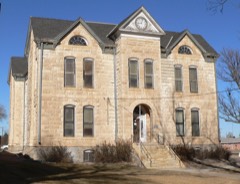 | Greeley County Courthouse | building | 1976 | 76000821 |
Every wildfire the federal occurrence database records inside this county: 8 of them, burning about 1 acre. None started naturally and 1 was recorded as arson. Each settlement page carries the fires within five miles of it.
| Reported cause | Fires |
|---|---|
| Missing data/not specified/undetermined | 5 |
| Debris and open burning | 2 |
| Arson/incendiarism | 1 |
The five largest, by the area the report gives. One of them was set deliberately.
| Date | Cause | Size | Reported by | Name on the report |
|---|---|---|---|---|
| 23 May 2006 | Arson/incendiarism | under an acre | Flint Hills National Wildlife Refuge | TRESSLE |
| 10 September 2017 | Missing data/not specified/undetermined | under an acre | Greeley County | 39 |
| 19 July 2018 | Missing data/not specified/undetermined | under an acre | Kansas Forest Service | 21 |
| 18 March 2017 | Debris and open burning | under an acre | Greeley County | 8 |
| 27 August 2017 | Missing data/not specified/undetermined | under an acre | Greeley County | 28 |
| 28 August 2017 | Missing data/not specified/undetermined | under an acre | Greeley County | 29 |
| 27 August 2017 | Debris and open burning | under an acre | Greeley County | 27 |
| 28 August 2017 | Missing data/not specified/undetermined | under an acre | Greeley County | 30 |
Every settlement page carries the fires within five miles of it - see the settlement index below.
The NOAA Storm Events Database holds 480 reports for this county, causing no deaths, no injuries and about $2,306,780 in recorded property damage. Each settlement page carries the reports that name it.
| Kind of event | Reports |
|---|---|
| Hail | 296 |
| Thunderstorm Wind | 121 |
| Tornado | 43 |
| Flash Flood | 13 |
| Flood | 6 |
| Funnel Cloud | 1 |
The most serious of them, by death, then injury, then recorded damage. The accounts are quoted exactly as the forecast office filed them.
| When | Event | Place named | Harm | What the report says |
|---|---|---|---|---|
| April 2015 | Thunderstorm Wind | New Almelo | $700,000 | An intense downburst swept across northern Greeley County producing significant damage and a dust storm dropping visibility to near zero in blowing dirt. Damage included overturned irrigation pivots, downed utility poles, sides and roofs of outbuilding removed and damage to a dairy farming operation. Gravel was scoured off county roads and embedded in trees and utility poles. Damage was consistent with winds of approximately 100 mph. The strong outflow continued across northern Wichita County and ultimately into Scott county. |
| June 1994 | Hail | Tribune | $500,000 | Hail (2.75 inch) was also reported 5 S Tribune at 2048 CST. The hail knocked holes in roofs, damaged windshields, and farm machinery. |
| July 1995 | Hail | Tribune | $400,000 | Large hail, high winds, and excessive rainfall caused extensive damage to wheat, corn and farm buildings. The wheat was only a week away from being harvested. USDA reports the heaviest hail damage was in a five mile wide strip across the northern and eastern sections of the county. |
| May 2010 | Thunderstorm Wind | Tribune Arpt | $150,000 | Straight line winds roared northeast across Greeley county during the evening producing a swath of damage which included: a large grain bin lifted off its foundation, a hay barn damaged, a shed destroyed, a grain bin blown across the road, the roof of a trailer home lifted off the home and destroyed, and a barn and grain bin destroyed. Numerous other trees and small outbuildings were damaged. |
| June 2010 | Thunderstorm Wind | Whitelaw | $100,000 | A possible microburst destroyed a newly build barn with debris blown to the northeast. A pickup truck parked inside was destroyed. |
| June 2006 | Thunderstorm Wind | Tribune | $81,000 | Shed damaged and 4 grain bins destroyed and thrown 800 yards. Wind speeds estimated. |
| July 1994 | Thunderstorm Wind | Horace | $50,000 | Thunderstorm winds damaged roofs, knocked down trees, and blew a large grain bin 200 yards. |
| May 1999 | Hail | Tribune | $50,000 | no account filed |
| June 2011 | Thunderstorm Wind | Tribune Arpt | $40,000 | A semi-trailer was blown off Highway 27, hitting a power pole which eventually fell on the semi. |
| September 2016 | Thunderstorm Wind | Whitelaw | $31,500 | Three or four power poles blown down. Estimated time of report from radar. |
| July 2010 | Thunderstorm Wind | Horace | $27,000 | Several power poles damaged along highway 27. An irrigation center pivot was also blown over with severe corn damage noted. |
| March 2007 | Tornado (EF0) | Tribune | $25,000 | Tornado began 5 WSW of Tribune and continued into Wallace county, Kansas, crossing the county border near Road 10. EF0 damage occurred in Greeley county. After the tornado crossed into Wallace county, it damaged three unoccupied mobile/modular homes producing EF1 damage. The tornado continued to 3 S of Weskan before dissipating. Other minor damage occurred along the path, however no homes were affected. |
| July 1982 | Tornado (F1) | not stated | $25,000 | no account filed |
| September 1976 | Tornado (F1) | not stated | $25,000 | no account filed |
| June 2014 | Thunderstorm Wind | Whitelaw | $20,000 | Strong thunderstorm outflow blew the roof off a barn and buckled 20 by 30 foot doors. |
| July 2010 | Thunderstorm Wind | Tribune Arpt | $10,000 | A cattle truck was blown over. |
| August 2007 | Thunderstorm Wind | Tribune | $10,000 | Mobile home destroyed, windows broken in house, shed blown over. |
| August 2002 | Thunderstorm Wind | Tribune | $10,000 | Two grain bins damaged, several trees uprooted. |
| June 2011 | Thunderstorm Wind | Whitelaw | $7,500 | Power poles were blown down on a county road 3 miles south of Highway 96 near the Greeley-Wichita county border. Time of report is estimated by radar. |
| June 2011 | Thunderstorm Wind | Whitelaw | $7,500 | Power poles were blown down on a county road 3 miles south of Highway 96 near the Greeley-Wichita county border. Time of report is estimated by radar. |
| June 2006 | Thunderstorm Wind | Tribune | $6,250 | Four to six inch diameter tree branches broken from numerous trees. Wind speeds estimated. |
| July 2010 | Hail | Horace | $5,750 | The windshield of a law enforcement vehicle was shattered. Wind and hail also broke windows at Hayhook Cattle Feeders in the office, scale house and on several vehicles. |
| August 2002 | Thunderstorm Wind | Tribune | $5,000 | Grain bins suffered minor damage, tree knocked over. |
| July 2018 | Thunderstorm Wind | Tribune Arpt | $3,000 | Thunderstorm winds blew doors off of a shed, and an entire milo field is destroyed. |
| July 2010 | Thunderstorm Wind | Horace | $3,000 | The roof of a home in Horace was damaged by thunderstorm winds. |
| May 1988 | Tornado (F1) | not stated | $2,500 | no account filed |
| September 2025 | Flood | Horace | $2,000 | Public photos of running water over County Road 17, just south of County Road L. This was 18 hours after the heavy rain had ended. |
| August 2018 | Thunderstorm Wind | Tribune | $1,500 | A tree was blown down in town from the thunderstorm winds. |
| July 2010 | Thunderstorm Wind | Tribune | $1,500 | Numerous tree limbs down in Tribune with a few whole trees felled in the northeast part of town. |
| August 2021 | Hail | Tribune | $1,000 | Multiple reports received of hail ranging from quarter size up to 3.5-inches in diameter in Tribune. A few car windshields were reported broken by the hail. Time is radar-estimated. |
| June 2011 | Thunderstorm Wind | Tribune Arpt | $1,000 | Windows were blown out of a tractor with straw blown into the cab. Report time is estimated from radar. |
| June 2002 | Thunderstorm Wind | Tribune | $1,000 | Power poles down |
| June 2002 | Thunderstorm Wind | Tribune | $1,000 | Power poles down |
| August 2014 | Thunderstorm Wind | Whitelaw | $500 | A picnic table and two motorcycles were overturned. |
| August 2013 | Hail | Horace | $500 | Car windows broken out while traveling K-96 west into Kiowa County. Estimated time and location based on radar. |
| June 2012 | Thunderstorm Wind | Tribune | $500 | A 6 inch diameter Russian Olive tree was blown over. |
| August 2009 | Flood | Horace | $500 | Law enforcement reported water running across County Road 14 about 6-7 miles south of the Wallace-Greeley County line. Radar indicates the heavy rain fell during the middle to late afternoon hours and continued to affect low lying areas on county roads through the evening. |
| July 1998 | Thunderstorm Wind | Whitelaw | $500 | Spotter estimated 70 MPH winds which blew a horse trailer into a shed and downed two sections of fence. Tree limbs up to eight inches in diameter were broken. |
| April 2010 | Hail | Tribune | $250 | The public reported that the hail broke a window. |
| June 1957 | Tornado (F0) | not stated | $30 | no account filed |
| April 2025 | Hail | Horace | - | Greeley County dispatch relayed a report of golf ball sized hail near the Kansas/Colorado border. |
| June 2025 | Thunderstorm Wind | Horace | - | AWN Mesonet reported a 62 MPH wind gust. |
| July 2025 | Thunderstorm Wind | Horace | - | The Kansas Mesonet site reported a 2 meter wind gust of 59 mph. |
| July 2025 | Thunderstorm Wind | Tribune | - | Emergency manager reported a block to a block and a half visibility due to dust associated with thunderstorm outflow. Local mesonet winds were recorded around 45 mph gusts. |
| July 2025 | Thunderstorm Wind | Whitelaw | - | Local dispatch reported near zero visibility in a wall of dust 6 miles east of Tribune. Local mesonet winds were recorded around 45 mph gusts. |
| July 2025 | Thunderstorm Wind | Horace | - | Spotter estimates 60 mph wind gusts and near zero visibility in rain on Hwy 96 near KS/CO border. |
| July 2025 | Thunderstorm Wind | Tribune | - | Trained spotter estimates winds around 58 mph. Supported by sending in a video. |
| July 2025 | Thunderstorm Wind | Whitelaw | - | Site 5.5 miles east of Tribune reports 72 mph wind gust. |
| July 2025 | Thunderstorm Wind | Tribune Arpt | - | Site DW9439 reported 62 mph wind gust. |
| August 2025 | Hail | Horace | - | Hailed along the highway, estimated at half dollar size. |
| August 2025 | Hail | Horace | - | Photos provided showing hail next to ruler up to 2 inches in size. |
| August 2025 | Thunderstorm Wind | Horace | - | Kansas mesonet site KS-Tribune measured 61 mph wind gust. |
| August 2025 | Hail | Tribune | - | Various hail sizes noted with the largest being up to golf ball sized. |
| August 2025 | Tornado (EFU) | Tribune Arpt | - | Multiple reports from chasers of a tornado that tracked near CR Z and CR 9 intersection. Further supported by livestream. Did not look to be ongoing after a minute or two. |
| August 2025 | Tornado (EFU) | Horace | - | Report from dispatch of a tornado that touched the ground and went back up quickly. It was not ongoing as of the report. |
| September 2025 | Thunderstorm Wind | Whitelaw | - | Measured from the mesonet site named KKSTRIBU27. |
| May 2024 | Hail | Tribune | - | Greeley county dispatch reported pea to nickel sized hail in Tribune. |
| April 2024 | Hail | Tribune | - | Quarter to half dollar sized hail was ongoing for a duration of 2 minutes. |
| April 2024 | Hail | Tribune | - | Trained spotter report via social media with photos and video of quarter to half dollar size hail. |
| May 2024 | Hail | Horace | - | Reports from MPing of hail starting at 0.75 inches and growing to 1.25 inches. |
Named settlements recorded in the Geographic Names Information System, each with the topographic sheets covering it. Villages, hamlets and abandoned places alike. Each is shown with the nearest named watercourse or landform and the survey quadrangle it falls on.
Tribune township · 67879 · Tribune quadrangle
8 sheets, 1955 to 1987