 Block
From the record
2 National Register listings published here.
Sources: the National Register database, National Park Service
42 topographic sheets cover 5 settlements here, and 2 properties are on the National Register of Historic Places.
2 National Register listings published here.
Sources: the National Register database, National Park Service
Every property in this county listed on the National Register of Historic Places, with the year it was listed and the federal nomination document.
| Photograph | Property | Type | Listed | Reference |
|---|---|---|---|---|
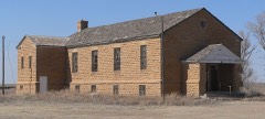 | Menno Community Hall | building | 2003 | 02001700 |
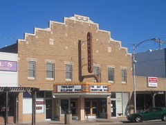 | Northup Theater | building | 2005 | 05000008 |
Every wildfire the federal occurrence database records inside this county: 7 of them, burning about 5,503 acres. 1 started naturally and none was recorded as arson. Each settlement page carries the fires within five miles of it.
| Reported cause | Fires |
|---|---|
| Missing data/not specified/undetermined | 4 |
| Natural | 1 |
| Fireworks | 1 |
| Debris and open burning | 1 |
The five largest, by the area the report gives. None of them was recorded as arson.
| Date | Cause | Size | Reported by | Name on the report |
|---|---|---|---|---|
| 25 May 2006 | Missing data/not specified/undetermined | 3,500 acres | Hamilton County | not named |
| 30 October 2007 | Missing data/not specified/undetermined | 1,000 acres | Kansas Counties | FRONTIER |
| 19 February 2016 | Debris and open burning | 1,000 acres | Kansas Forest Service | 6 |
| 27 September 2015 | Missing data/not specified/undetermined | 3.0 acres | Kansas Forest Service | 32 |
| 11 November 2016 | Missing data/not specified/undetermined | under an acre | Kansas Forest Service | 1600027 |
| 29 July 2018 | Natural | under an acre | Kansas Forest Service | 1800012 |
| 5 July 2015 | Fireworks | under an acre | Kansas Forest Service | 1500008 |
Every settlement page carries the fires within five miles of it - see the settlement index below.
The NOAA Storm Events Database holds 621 reports for this county, causing no deaths, 1 injury and about $734,560 in recorded property damage. Each settlement page carries the reports that name it.
| Kind of event | Reports |
|---|---|
| Hail | 395 |
| Thunderstorm Wind | 166 |
| Tornado | 36 |
| Heavy Rain | 15 |
| Flash Flood | 4 |
| Flood | 4 |
| Funnel Cloud | 1 |
The most serious of them, by death, then injury, then recorded damage. The accounts are quoted exactly as the forecast office filed them.
| When | Event | Place named | Harm | What the report says |
|---|---|---|---|---|
| July 1966 | Tornado (F2) | not stated | 1 hurt, $25,000 | no account filed |
| June 1990 | Tornado (F2) | not stated | $250,000 | no account filed |
| May 1954 | Tornado (F2) | not stated | $250,000 | no account filed |
| May 2001 | Thunderstorm Wind | Coolidge | $50,000 | Pivot sprinkler overturned. |
| September 1993 | Hail | Syracuse | $50,000 | no account filed |
| May 1999 | Hail | Coolidge | $30,000 | Swath of hail and high wind across the northern 1/4 of the county produced $30,000 damage to property. Damage was also done to crops. Do not have dollar figure available. |
| May 1962 | Tornado (F2) | not stated | $25,000 | no account filed |
| July 2010 | Thunderstorm Wind | Coolidge | $10,000 | The roof of a 30 x 60 foot shed was blown about 40 feet. Six power poles were blown down and a large tree was uprooted. Also a large water tank was rolled over 200 feet. |
| March 2000 | Thunderstorm Wind | Syracuse | $10,000 | Grain bin destroyed. |
| June 1994 | Hail | Syracuse | $5,000 | no account filed |
| June 1994 | Hail | Syracuse | $5,000 | no account filed |
| September 1993 | Hail | Kendall | $5,000 | no account filed |
| May 1988 | Tornado (F0) | not stated | $2,500 | no account filed |
| July 1966 | Tornado (F0) | not stated | $2,500 | no account filed |
| November 1963 | Tornado (F2) | not stated | $2,500 | no account filed |
| June 1951 | Tornado | not stated | $2,500 | no account filed |
| June 2001 | Thunderstorm Wind | Syracuse | $2,000 | Four power poles destroyed. |
| May 1999 | Thunderstorm Wind | Syracuse | $2,000 | Power poles down across highway 27. |
| June 1996 | Thunderstorm Wind | Syracuse | $2,000 | no account filed |
| October 2002 | Thunderstorm Wind | Kendall | $1,000 | A cattle feed bunk was blown 1/4 of a mile. |
| June 2002 | Thunderstorm Wind | Syracuse | $1,000 | A couple of power poles were blown down. |
| June 1996 | Thunderstorm Wind | Syracuse | $1,000 | no account filed |
| June 1994 | Hail | Syracuse | $500 | no account filed |
| June 1983 | Tornado (F0) | not stated | $30 | no account filed |
| August 1977 | Tornado (F0) | not stated | $30 | no account filed |
| September 2025 | Thunderstorm Wind | Syracuse | - | AWOS station K3K3 Syracuse recorded a 69 mph wind gust. |
| September 2025 | Thunderstorm Wind | Syracuse | - | AWOS station K3K3 Syracuse recorded a 59 mph wind gust. |
| August 2025 | Tornado (EFU) | Medway | - | Storm chaser video showed a brief tornado last for a couple minutes. No damage was found. |
| August 2025 | Hail | Syracuse | - | A storm chaser reported 2.75 inch hail and included pictures via social media. |
| August 2025 | Hail | Syracuse | - | Public reported 2 inch hail. |
| August 2025 | Thunderstorm Wind | Syracuse | - | AWOS station K3K3 Syracuse recorded a 58 mph wind gust. |
| July 2025 | Thunderstorm Wind | Syracuse | - | Reported by a mesonet station. |
| July 2025 | Thunderstorm Wind | Syracuse | - | Measured by the AWOS station at Syracuse. |
| July 2025 | Thunderstorm Wind | Coolidge | - | Measured by the mesonet station K5COO. |
| July 2025 | Thunderstorm Wind | Coolidge | - | Department of highways measured a 63 mph wind gust. |
| June 2024 | Thunderstorm Wind | Coolidge | - | Sixty to seventy mph thunderstorm wind gusts were estimated. |
| July 2024 | Thunderstorm Wind | Kendall | - | Strong thunderstorms wind gusts were measured by a mesonet station. |
| April 2024 | Tornado (EF0) | Kendall | - | Damaged outbuilding and power poles. Reported as a tornado with picture but could be a tornado or landspout. |
| April 2024 | Thunderstorm Wind | Kendall | - | Damaged outbuilding and power poles. |
| September 2024 | Thunderstorm Wind | Kendall | - | Mesonet site recorded a wind gust of 60 MPH. |
| June 2022 | Thunderstorm Wind | Syracuse | - | Winds were estimated to be 70 MPH. |
| June 2021 | Thunderstorm Wind | Coolidge | - | Winds gusted to approximately 60 MPH. |
| June 2021 | Thunderstorm Wind | Coolidge | - | Wind gusts to 60 MPH were estimated. |
| May 2021 | Heavy Rain | Coolidge | - | Rainfall of 3.60 was reported. |
| September 2021 | Hail | Kendall | - | Most of the hail was small but the ground was completely covered as the hail lasted up to 10 minutes. |
| July 2021 | Thunderstorm Wind | Coolidge | - | Damage was done to a roof and a patio cover was torn off by high winds. In addition, tree limbs were broken. |
| May 2020 | Tornado (EF0) | Coolidge | - | This was one of two twin landspout tornadoes. |
| May 2020 | Tornado (EF0) | Coolidge | - | This was one of two twin landspout tornadoes. |
| May 2020 | Tornado (EF0) | Syracuse | - | This was another landspout tornado. |
| July 2020 | Heavy Rain | Syracuse | - | Rainfall of 2.96 inches was observed. |
| July 2020 | Thunderstorm Wind | Syracuse | - | Measured on a home weather station. |
| June 2019 | Flash Flood | Syracuse | - | Water was crossing Highway 27 near CR13. |
| July 2019 | Thunderstorm Wind | Coolidge | - | A tree was blown into a house. |
| May 2019 | Thunderstorm Wind | Syracuse | - | Winds were estimated to be at least 60 MPH. |
| August 2019 | Funnel Cloud | Syracuse | - | There was a rotating wall cloud with funnel cloud observed. |
| September 2018 | Heavy Rain | Coolidge | - | Rainfall of 1.20 inches was measured. |
| July 2018 | Tornado (EF0) | Syracuse | - | A land spout tornado moved south and then turned west before dissipating. |
| May 2018 | Hail | Coolidge | - | Winds were 40 to 50 MPH. |
| May 2018 | Hail | Mayline | - | Winds were also 50 to 60 MPH. |
| May 2018 | Thunderstorm Wind | Kendall | - | There were some broken windows in vehicles and buildings from flying tree limbs. |
Named settlements recorded in the Geographic Names Information System, each with the topographic sheets covering it. Villages, hamlets and abandoned places alike. Each is shown with the nearest named watercourse or landform and the survey quadrangle it falls on.
Coolidge township · 67836 · On Bridge Creek · Holly East quadrangle
17 sheets, 1890 to 1988
Syracuse township · 67878 · On Sand Creek · Syracuse East quadrangle
14 sheets, 1900 to 1987
Medway township · 67878 · On East Bridge Creek · East Bridge Creek South quadrangle
9 sheets, 1955 to 1987
Syracuse township · 67878 · On Syracuse Creek · Syracuse West quadrangle
14 sheets, 1900 to 1987