 Block
From the record
10 National Register listings published here.
Sources: the National Register database, National Park Service
44 topographic sheets cover 15 settlements here, and 10 properties are on the National Register of Historic Places.
10 National Register listings published here.
Sources: the National Register database, National Park Service
Every property in this county listed on the National Register of Historic Places, with the year it was listed and the federal nomination document.
| Photograph | Property | Type | Listed | Reference |
|---|---|---|---|---|
| Anthony Public Carnegie Library | building | 1987 | 87000954 | |
| Anthony Theater | building | 1991 | 91000464 | |
| I.P. Campbell Building | building | 2006 | 06000600 | |
| First Congregational Church | building | 2014 | 14000349 | |
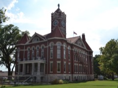 | Harper County Courthouse | building | 1978 | 78001282 |
| Harper Standpipe | structure | 2017 | 100001288 | |
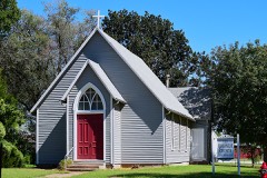 | Old Runnymede Church | building | 1973 | 73000758 |
| Thompson-Wohlschlegel Round Barn | building | 1985 | 85000315 | |
| Transcontinental Airway Beacon | structure | 2024 | 100010565 | |
| US Post Office-Anthony | building | 1989 | 89001631 |
Every wildfire the federal occurrence database records inside this county: 39 of them, burning about 4,119 acres. None started naturally and 3 were recorded as arson. Each settlement page carries the fires within five miles of it.
| Reported cause | Fires |
|---|---|
| Missing data/not specified/undetermined | 18 |
| Equipment and vehicle use | 9 |
| Debris and open burning | 9 |
| Arson/incendiarism | 3 |
The five largest, by the area the report gives. None of them was recorded as arson.
| Date | Cause | Size | Reported by | Name on the report |
|---|---|---|---|---|
| 13 March 2015 | Missing data/not specified/undetermined | 3,000 acres | Harper County | WALDRON |
| 16 March 2018 | Debris and open burning | 500 acres | Kansas Forest Service | 2383 |
| 17 June 2020 | Equipment and vehicle use | 410 acres | Kansas Forest Service | not named |
| 18 February 2018 | Debris and open burning | 125 acres | Kansas Forest Service | 1494 |
| 30 November 2000 | Missing data/not specified/undetermined | 20 acres | Southern Plains Regional Office | BUFFALO |
| 15 June 2020 | Equipment and vehicle use | 20 acres | Kansas Forest Service | not named |
| 13 August 2020 | Debris and open burning | 10 acres | Kansas Forest Service | not named |
| 24 June 2017 | Equipment and vehicle use | 7.0 acres | Harper County | 2017032 |
Every settlement page carries the fires within five miles of it - see the settlement index below.
The NOAA Storm Events Database holds 709 reports for this county, causing no deaths, 7 injuries and about $11,674,240 in recorded property damage. Each settlement page carries the reports that name it.
| Kind of event | Reports |
|---|---|
| Hail | 362 |
| Thunderstorm Wind | 241 |
| Tornado | 64 |
| Flash Flood | 23 |
| Flood | 10 |
| Heavy Rain | 6 |
| Lightning | 2 |
| Funnel Cloud | 1 |
The most serious of them, by death, then injury, then recorded damage. The accounts are quoted exactly as the forecast office filed them.
| When | Event | Place named | Harm | What the report says |
|---|---|---|---|---|
| April 2004 | Thunderstorm Wind | Harper | 3 hurt, $75,000 | Historic Red Barn, 115 years old and under renovation, collapsed. All three men pinned in the rubble were injured. One man required air med-evac to Wesley Medical Center in Wichita where, upon arrival, he was listed in critical condition. (By Friday Night, his condition had been upgraded to "fair".) A 2nd required ambulance transport to Via Christi Regional Medical Center in Wichita where he was listed in fair condition. The 3rd man did not seek medical attention. In addition, the following sustained significant damage: 12 homes, 4 businesses (including the Elko Building on west side of town that lost a 20 by 30 foot section of roofing on the west side of the structure causing the west wall to buckle inward), one shop, a camper that was blown over and rolled nearly 100 feet, and the roof of a carport that was dislodged and blown over the roof of the mobile home to which it had been attached. Obviously, damage to trees, power lines, and power poles was extensive. The latter two severed power to Harper for approximately 5 hours. (Narratives courtesy of Wichita Eagle, Winfield Daily Courier, Anthony Republican, and Harper Advocate.) |
| April 2009 | Flash Flood | Corwin | 1 hurt, $5,000,000 | Heavy rainfall from numerous thunderstorms during the afternoon, evening and overnight hours on the 26th produced widespread flooding across much of Harper county. Rainfall amounts across the county ranged from 3 to 6 inches. Numerous roads were closed countywide. It is estimated that around 100 homes were flooded or received some form of water damage in the Anthony area, along with several other homes and businesses across the county. Portions of the elementary school and hospital in Harper were flooded. Three water rescues took place, one of which produced an injury near Third Lake Road when a vehicle attempted to cross a flooded roadway. Crop damage estimates are unknown, and property damage values are rough estimates. The Wichita Eagle, Harper Advocate, Anthony Republican and the Hutchinson News contributed to this report. |
| April 2004 | Thunderstorm Wind | Harper | 1 hurt, $350,000 | Large tree fell onto mobile home. One woman injured, sustaining fractured vertebrae, requiring ambulance transport to Via Christi Regional Medical Center in Wichita where, upon arrival, the woman was listed in fair condition. (Narrative courtesy of Wichita Eagle, Winfield Courier, Anthony Republican, and Harper Advocate.) |
| May 2004 | Tornado (F4) | Harper | 1 hurt, $275,000 | Large destructive tornado completely demolished a two story farm house and 5 other barns associated with the homestead. Five cars were also dismantled as the engines were spread across the shaven wheat fields. Very few automobile body parts could be located. |
| April 2004 | Lightning | Freeport | 1 hurt | Girl, 16 years old, struck while showering. Victim was transported to Anthony Hospital where she was listed in stable condition. No indications of damage. (Narrative courtesy of Wichita Eagle.) |
| May 2004 | Tornado (F1) | Freeport | $1,200,000 | The following were damaged or destroyed: 15 farm dwellings and service buildings, and 30 pieces of farm machinery and equipment. (This portion of narrative courtesy of USDA Flash Flood Situation report.) One home unroofed resulting in damage to most of property inside. Widespread damage to wheat fields that had been ready for harvest. |
| May 2007 | Flash Flood | Harper | $1,000,000 | Flash flooding was reported across the county. Numerous roads were closed due to high water and sand bagging was conducted in the city of Harper. |
| July 2009 | Hail | Runnymede | $300,000 | A supercell moved southeast across northern and eastern portions of Harper county, producing a swath of golfball to baseball size hail and 60 to 70 mph winds from just east of Runnymede, southeast through the Danville and Freeport areas. A narrow swath of intense damage occurred, including uprooted trees, shattered car and building windows, at least three damaged irrigation systems, a damaged stock show trailer, structural and roof damage to several barns and homes, damage to various sheds and outbuildings, and devastating crop damage to soybeans, milo and corn. Additionally, a camper trailer was thrown into a field near Danville, and a railroad crossing was blown down just east of Danville. Property and crop monetary damage amounts are rough estimates. The Harper Advocate and Hutchinson News contributed to this narrative. |
| June 2008 | Thunderstorm Wind | Attica | $250,000 | Strong winds blew over five double stacked railroad cars. An estimated 40 containers were blown with both tracks of the railroad being blocked. The railroad containers were full of paper, cereal and other non hazardous materials. |
| June 2007 | Flash Flood | Attica | $250,000 | Harper County Law Enforcement reported a water rescue on Highway 160 just west of Attica. A later report from Law Enforcement indicated that there was 4 feet of water flowing over the highway. Flash flooding was also reported in the town of Harper early in the morning. Numerous washouts were reported across the county. The Harper Advocate contributed to this report. |
| March 1990 | Tornado (F1) | not stated | $250,000 | no account filed |
| May 1981 | Tornado (F1) | not stated | $250,000 | no account filed |
| October 1973 | Tornado (F1) | not stated | $250,000 | no account filed |
| May 2004 | Tornado (F1) | Harper | $220,000 | Tornado moved northeast across an open field before taking direct aim on Chaparral High School. The tornado ripped off the pressbox of the football stadium and peeled back part of the roof. |
| May 2004 | Tornado (F2) | Anthony | $175,000 | The tornado mainly moved over open country damaging wheat fields that were ready to be harvested, however, one home completely lost it's roof and most of the belongings inside. |
| July 2005 | Thunderstorm Wind | Attica | $150,000 | Four homes unroofed with damage to garages. Two downtown businesses sustained unspecified damage. (Narrative courtesy Central Region Significant Event Report.) |
| May 2004 | Tornado (F2) | Attica | $140,000 | Large dusty tornado moved north just on the outskirts of the city. The tornado had a direct hit on an ECO block home. The home lost it's roof, but all exterior walls remained in tact. Two metal barns were also lost in the tornado. |
| May 2004 | Tornado (F2) | Harper | $140,000 | Large tornado moved over open country before hitting a farmstead and shearing off the roof of a veterinarians clinic and the top floor of a two story home. |
| September 2008 | Flash Flood | Harper | $100,000 | A foot of water was reported over Highway 160 in the town of Harper. Water ran curb to curb along Highway 160 through town. Portions of South Pine and South Central were barricaded. A Harper police partol car had to be removed from service after water flooded the interior. |
| July 2005 | Thunderstorm Wind | Bluff City | $100,000 | Extensive roof damage, with some buldings completely unroofed. No details provided as to type and number of buildings victimized. Downed power lines and power poles with power severed across town. Outbuildings destroyed. |
| July 2005 | Thunderstorm Wind | Bluff City | $100,000 | KanOkla telephone building unroofed. An old school and an unspecified number of residences sustained broken windows. Downed power lines and power poles resulted in severed power across town. (Narrative courtesy Central Region Significant Event Report.) |
| May 2004 | Tornado (F2) | Harper | $100,000 | Tornado moved NNE on the outskirts of Harper. The tornado sheared off the top portion of a two story home and sending debris for several hundred yards. |
| May 2004 | Tornado (F1) | Danville | $100,000 | The tornado hit a machine shop and caused considerable damage. |
| July 2003 | Hail | Attica | $100,000 | Major roof damage, the most dramatic of which was caused by one hailstone, reportedly possessing a 10.5 inch circumference, penetrating the roof of the victimized house and landing in a closet. The Attica Independent News contributed greatly to this report. |
| June 1997 | Thunderstorm Wind | Danville | $75,000 | ONE BARN DESTROYED & ONE SILO DAMAGED. |
| June 2009 | Thunderstorm Wind | Anthony | $56,000 | Damaging winds estimated at 70 mph moved across areas just west of Anthony. The winds knocked down 11 power poles. The winds knocked down numerous trees at Anthony Lake damaging some cabins and also overturning a camper. |
| April 2004 | Thunderstorm Wind | Harper | $50,000 | Measured by KSN Weatherlab, Chaparral High School, where hail, although only 1/4 inch diameter, occasionally reached 6-inch depths. Between 50 and 75% of the wheat crop, between 150,00 and 172,500 acres, destroyed. The destroyed wheat crop fell into two categories: 1) Headed wheat that was sliced and 2) Wheat that was completely shredded. Approximately 75% of the alfalfa crop, totalling 3,000 acres, was shredded. No dollar estimate in crop losses was available at the time of this report. |
| May 2004 | Tornado (F1) | Attica | $50,000 | Tornado mainly moved through a wheat field, however, it did produce considerable tree damage and minor damage to one roof. |
| April 1999 | Thunderstorm Wind | Waldron | $50,000 | At one farmstead, a roundtop was blown off it's foundation and demolished. Part of the roundtop stuck into a silo located immediately north of where roundtop had been positioned. |
| June 1994 | Thunderstorm Wind | Anthony | $50,000 | Three inch diameter tree limbs were blown down. Winds 85 to 90 mph in Anthony knocked down trees and limbs. A long hangar at the airport was flattened damaging seven airplanes. |
| August 2003 | Thunderstorm Wind | Harper | $30,000 | Metal roofing torn from hangar at Harper County Airport. Private plane parked inside the hangar sustained minor damage. Unspecified number of power poles and power lines downed. However, power was severed to Harper's primary water well, which would be out of service until Monday afternoon (8/25). A second water well failed Sunday Night (8/24), with service also restored Monday afternoon (8/25). The Harper Advocate contributed greatly to this narrative. |
| June 2008 | Thunderstorm Wind | Anthony | $27,000 | High winds knocked out power to Anthony. |
| July 2003 | Tornado (F0) | Harper | $25,000 | Minor wind damage to trees and power lines. |
| June 2002 | Hail | Freeport | $25,000 | Roof damage and windows smashed on cars and homes. |
| June 2001 | Lightning | Anthony | $25,000 | Lightning struck a chimney causing it to explode. Two of the bricks struck a southward-neighboring house where one brick smashed a window with the second striking the roof with sufficient force to leave a powdery, brick-red mark on the shingles. In addition to destroying the chimney, the lightning strike also blew out an exterior electrical outlet on the south side and damaged insulation in the attic. |
| April 1999 | Tornado (F0) | Duquoin | $25,000 | Weak tornado, embedded in strong downburst winds, inflicted damage to one double-wide home. Damage was mainly to the roof and due to tree limb impalement to west side of house. One shed was also damaged. |
| November 1998 | Thunderstorm Wind | Danville | $25,000 | Roof damage was reported on 4 homes. |
| May 1998 | Tornado (F0) | Waldron | $25,000 | Power poles damaged 4 miles east of Waldron. |
| October 1973 | Tornado (F1) | not stated | $25,000 | no account filed |
| May 2016 | Thunderstorm Wind | Attica | $20,000 | Trees were blown down across town. Some of the trees were 12 inches in diameter. |
| June 2008 | Thunderstorm Wind | Anthony | $20,000 | A 92 mph wind gust was recorded near Anthony which knocked down trees and several power poles. |
| July 2005 | Thunderstorm Wind | Harper | $15,000 | Armory, one building, and one residence sustained roof damage. (Report and narrative courtesy Central Region Significant Event Report.) |
| April 2004 | Thunderstorm Wind | Anthony | $15,000 | Roof blown off a barn. (Narrative courtesy Anthony Republican.) |
| July 2002 | Thunderstorm Wind | Anthony | $15,000 | Numerous power lines, power poles, and trees downed. |
| February 2012 | Thunderstorm Wind | Anthony | $10,000 | Extensive damage was inflicted on a storage unit in Anthony. |
| September 2008 | Flash Flood | Anthony | $10,000 | Kansas Highway 44 east of Anthony and Kansas State road 179 south of Anthony were closed due to high water. Also, many county roads were closed throughout the county. |
| August 2004 | Thunderstorm Wind | Attica | $10,000 | Dwoned power lines across town. |
| July 2002 | Thunderstorm Wind | Danville | $10,000 | Power lines, power poles and trees downed. |
| May 1998 | Thunderstorm Wind | Harper | $10,000 | Machine shed blown over. Numerous trees downed. |
| June 1996 | Thunderstorm Wind | Harper | $10,000 | no account filed |
| September 1998 | Thunderstorm Wind | Harper | $8,000 | Eight power poles blown down along highway K-2. |
| August 2010 | Thunderstorm Wind | Attica | $6,000 | Law enforcement reported several power lines were down, along with some small trees knocked over. |
| May 2018 | Thunderstorm Wind | Harper | $5,000 | Power outages were reported. |
| May 2018 | Thunderstorm Wind | Anthony | $5,000 | Tree and power line damage likely resulted as power outages had been reported in and around Harper. |
| May 2018 | Thunderstorm Wind | Harper | $5,000 | The estimated 70-mph winds caused power outages in Harper. |
| April 2012 | Thunderstorm Wind | Waldron | $5,000 | One utility pole was downed, along with sporadic tree damage. |
| June 2008 | Thunderstorm Wind | Harper | $5,000 | Several shed roofs were blown off from high winds. |
| July 2000 | Thunderstorm Wind | Attica | $5,000 | Falling tree limbs downed power lines. |
| May 1993 | Thunderstorm Wind | Attica | $5,000 | no account filed |
| May 1993 | Thunderstorm Wind | Attica | $5,000 | no account filed |
Named settlements recorded in the Geographic Names Information System, each with the topographic sheets covering it. Villages, hamlets and abandoned places alike. Each is shown with the nearest named watercourse or landform and the survey quadrangle it falls on.
Township 2 · 67150 · On Middle Branch Bluff Creek · Waldron quadrangle
15 sheets, 1889 to 1985