 Block
From the record
4 National Register listings published here.
Sources: the National Register database, National Park Service
18 topographic sheets cover 6 settlements here, and 4 properties are on the National Register of Historic Places.
4 National Register listings published here.
Sources: the National Register database, National Park Service
Every property in this county listed on the National Register of Historic Places, with the year it was listed and the federal nomination document.
| Photograph | Property | Type | Listed | Reference |
|---|---|---|---|---|
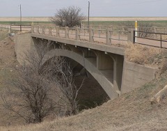 | Hackberry Creek Bridge | structure | 1985 | 85001424 |
 | T. S. Haun House | building | 1973 | 73000759 |
 | Hodgeman County Courthouse | building | 2002 | 02000429 |
 | St. Mary's Catholic Church | building | 2015 | 15000144 |
Every wildfire the federal occurrence database records inside this county: 18 of them, burning about 11,303 acres. None started naturally and 1 was recorded as arson. Each settlement page carries the fires within five miles of it.
| Reported cause | Fires |
|---|---|
| Missing data/not specified/undetermined | 14 |
| Smoking | 2 |
| Power generation/transmission/distribution | 1 |
| Arson/incendiarism | 1 |
The five largest, by the area the report gives. None of them was recorded as arson.
| Date | Cause | Size | Reported by | Name on the report |
|---|---|---|---|---|
| 15 March 2006 | Missing data/not specified/undetermined | 6,400 acres | Kansas Counties | HODGEMAN WEST |
| 15 March 2006 | Missing data/not specified/undetermined | 4,480 acres | Kansas Counties | HODGEMAN EAST |
| 30 January 2017 | Missing data/not specified/undetermined | 301 acres | Hodgeman County | 2 |
| 17 April 2015 | Smoking | 50 acres | Kansas Forest Service | 1 |
| 24 February 2016 | Smoking | 30 acres | Kansas Forest Service | 8 |
| 17 November 2015 | Missing data/not specified/undetermined | 15 acres | Kansas Forest Service | 1 |
| 7 May 2020 | Missing data/not specified/undetermined | 10 acres | Kansas Forest Service | not named |
| 18 July 2019 | Missing data/not specified/undetermined | 10 acres | Kansas Forest Service | 236 |
Every settlement page carries the fires within five miles of it - see the settlement index below.
The NOAA Storm Events Database holds 711 reports for this county, causing no deaths, 4 injuries and about $4,587,460 in recorded property damage. Each settlement page carries the reports that name it.
| Kind of event | Reports |
|---|---|
| Hail | 408 |
| Thunderstorm Wind | 199 |
| Tornado | 60 |
| Heavy Rain | 32 |
| Flash Flood | 5 |
| Flood | 5 |
| Funnel Cloud | 2 |
The most serious of them, by death, then injury, then recorded damage. The accounts are quoted exactly as the forecast office filed them.
| When | Event | Place named | Harm | What the report says |
|---|---|---|---|---|
| May 1991 | Tornado (F3) | not stated | 2 hurt, $250,000 | no account filed |
| April 1972 | Tornado (F4) | not stated | 1 hurt, $250,000 | no account filed |
| September 1959 | Tornado (F2) | not stated | 1 hurt, $2,500 | no account filed |
| May 2015 | Flash Flood | Jetmore | $3,000,000 | Numerous county roads were washed out due to flash flooding. |
| April 1976 | Tornado (F1) | not stated | $250,000 | no account filed |
| March 2007 | Tornado (EF3) | Jetmore | $210,000 | This large tornado destroyed three homes and did damage to one other. Hundreds of power poles were broken along with a handful of pivot irrigation sprinklers and barns. Trees also sustained major damage. There were also at least 50 head of cattle dead from this tornado in Hodgeman county. Parts of the debris from a shed were found 40 miles north. A wedding book registry was found intact 34 miles from the original location in a home that was destroyed. This tornado continued into Ness county at 925 PM CDT. |
| June 1996 | Thunderstorm Wind | Jetmore | $200,000 | no account filed |
| May 2019 | Tornado (EF1) | Gray | $60,000 | This QLCS tornado heavily damaged a pivot irrigation sprinkler. |
| October 2017 | Thunderstorm Wind | Hanston | $60,000 | Five miles of power poles, or around 80, were blown down by the high wind along US Highway 156. |
| October 2021 | Thunderstorm Wind | Jetmore | $55,000 | A pivot irrigation sprinkler was overturned by the high wind. There was also a large tree blown down and damage was done to a shed. |
| May 2007 | Thunderstorm Wind | Gray | $55,000 | Center irrigation pivot sprinkler blown over. |
| March 2017 | Thunderstorm Wind | Jetmore Muni Arpt | $50,000 | A pivot irrigation sprinkler was overturned by high wind. |
| June 1994 | Thunderstorm Wind | Jetmore | $50,000 | Ten power poles downed. |
| June 1968 | Tornado (F2) | not stated | $25,000 | no account filed |
| April 1964 | Tornado (F2) | not stated | $25,000 | no account filed |
| May 2008 | Flood | Hanston | $12,000 | The Emergency Manager reported water over several county roads and was greater than six inches deep. |
| August 2003 | Thunderstorm Wind | Jetmore | $10,000 | A 30 by 40 foot shed was destroyed and a grain cart was moved 10 feet. |
| May 2025 | Thunderstorm Wind | Jetmore | $5,000 | Pictures via social media show large section of a tree fell onto a house in Jetmore with several other large tree branches and a flag pole broken across town. |
| May 2008 | Thunderstorm Wind | Jetmore | $3,000 | Five power poles were blown down. |
| May 2008 | Thunderstorm Wind | Hanston | $3,000 | Five power poles were snapped off by the high wind. |
| March 2007 | Tornado (EF1) | Howell | $2,500 | This tornado moved out of Ford county at 834 PM and ended just before a much bigger tornado formed west of Jetmore. Damage was done to power poles. |
| July 1968 | Tornado | not stated | $2,500 | no account filed |
| April 1955 | Tornado (F1) | not stated | $2,500 | no account filed |
| June 1998 | Hail | Hanston | $1,800 | Windshield broken. |
| April 2008 | Thunderstorm Wind | Jetmore | $1,500 | Several power poles were blown down 1/2 mile east of Jetmore. The downed power lines also started a grass fire. |
| June 1999 | Thunderstorm Wind | Jetmore | $600 | Two power poles blown down. |
| September 1967 | Tornado (F0) | not stated | $250 | no account filed |
| June 1961 | Tornado (F1) | not stated | $250 | no account filed |
| May 1983 | Tornado (F0) | not stated | $30 | no account filed |
| May 1983 | Tornado (F0) | not stated | $30 | no account filed |
| May 2025 | Thunderstorm Wind | Jetmore | - | Photos on social media show power poles downed east of Hodgeman Medical Center. |
| May 2025 | Thunderstorm Wind | Hanston | - | A personal weather station recorded a wind gust of 65 mph. The same station again recorded 65 mph a few minutes later. |
| May 2025 | Thunderstorm Wind | Jetmore | - | Kansas State Mesonet site Hodgeman County measured an 88 mph wind gust. |
| April 2025 | Hail | Jetmore Muni Arpt | - | Public report of 1 inch hail. |
| April 2025 | Hail | Jetmore Muni Arpt | - | Emergency manager reported 2 inch hail. |
| August 2025 | Hail | Jetmore | - | A public report of 1.75 inch hail. |
| May 2025 | Thunderstorm Wind | Jetmore | - | A public report via social media of a shed destroyed with pictures. |
| May 2025 | Thunderstorm Wind | Hanston | - | Report of 8 to 10 inch tree branches snapped via social media. |
| July 2025 | Thunderstorm Wind | Hanston | - | The report was from the B-Hart Farm AWN weather station. |
| July 2025 | Thunderstorm Wind | Hanston | - | This report was received from an AWN weather station. |
| July 2025 | Thunderstorm Wind | Gray | - | The wind was estimated to be gusting from 50 to 60 mph. Time estimated from radar. |
| August 2025 | Thunderstorm Wind | Hanston | - | A mesonet site recorded a 63 mph wind gust. |
| August 2025 | Thunderstorm Wind | Jetmore Muni Arpt | - | A mesonet site recorded a 71 mph wind gust. |
| October 2025 | Hail | Jetmore | - | A public report of 1 inch hail. |
| October 2025 | Thunderstorm Wind | Jetmore | - | A public report of a 60 mph wind gust. |
| October 2025 | Thunderstorm Wind | Jetmore | - | A CO-OP observer reported a 70 mph wind gust. |
| May 2024 | Thunderstorm Wind | Hanston | - | The wind was estimated at 70-80 mph from outflow ahead of incoming storms. A 16-18 inch round live tree broke off and fell on the house with only minor damage. There was an old garage with part of the roof torn off. |
| May 2024 | Thunderstorm Wind | Jetmore | - | Wind gust of 60 mph. |
| May 2024 | Heavy Rain | Hanston | - | Rainfall report of 1.85 inches. |
| May 2024 | Heavy Rain | Jetmore Muni Arpt | - | Rainfall report of 2.33 inches. |
| February 2023 | Thunderstorm Wind | Jetmore | - | The storm spotter described a small path of damage through the cemetery, including tree damage and head stone damage. A photograph of one head stone was shown to be flipped upside down. Time of event estimated based on radar data. |
| May 2022 | Hail | Hanston | - | Most of the stones were smaller than golf ball sized. |
| August 2021 | Tornado (EF0) | Jetmore Muni Arpt | - | This landspout tornado was observed from start to finish was did not damage any object other than kicking up dirt and field plant material. |
| October 2021 | Tornado (EF1) | Jetmore Muni Arpt | - | This was a qlcs tornado that moved out of Ford County. |
| July 2020 | Heavy Rain | Jetmore | - | Rainfall of 2.85 inches was observed. |
| July 2020 | Heavy Rain | Jetmore | - | Rainfall of 2.57 inches was observed with the majority falling in a 3 hour period. |
| June 2020 | Heavy Rain | Jetmore Muni Arpt | - | The majority of the rain fell in less than 2 hours and totaled 4.54 inches. |
| June 2020 | Thunderstorm Wind | Jetmore | - | Two barns were blown down by the high wind. |
| June 2019 | Thunderstorm Wind | Jetmore | - | Winds were estimated to be gusting to 60 MPH. |
| June 2019 | Thunderstorm Wind | Hanston | - | Winds were estimated to be 60 MPH. |
Named settlements recorded in the Geographic Names Information System, each with the topographic sheets covering it. Villages, hamlets and abandoned places alike. Each is shown with the nearest named watercourse or landform and the survey quadrangle it falls on.