 Block
From the record
5 National Register listings published here.
Sources: the National Register database, National Park Service
44 topographic sheets cover 11 settlements here, and 5 properties are on the National Register of Historic Places.
5 National Register listings published here.
Sources: the National Register database, National Park Service
Every property in this county listed on the National Register of Historic Places, with the year it was listed and the federal nomination document.
| Photograph | Property | Type | Listed | Reference |
|---|---|---|---|---|
| Delia State Bank | building | 2020 | 100004924 | |
 | Holton Bath House | building | 2009 | 09000351 |
| Hotel Josephine | building | 2024 | 100010299 | |
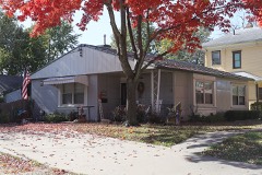 | McFadden House | building | 2001 | 01000187 |
 | State Bank of Holton | building | 1977 | 77000581 |
Every wildfire the federal occurrence database records inside this county: 490 of them, burning about 13,584 acres. 12 started naturally and 45 were recorded as arson. Each settlement page carries the fires within five miles of it.
| Reported cause | Fires |
|---|---|
| Debris and open burning | 255 |
| Missing data/not specified/undetermined | 114 |
| Arson/incendiarism | 45 |
| Equipment and vehicle use | 35 |
| Natural | 12 |
| Smoking | 8 |
| Recreation and ceremony | 7 |
| Other causes | 5 |
| Misuse of fire by a minor | 5 |
| Fireworks | 4 |
The five largest, by the area the report gives. Two of them were set deliberately.
| Date | Cause | Size | Reported by | Name on the report |
|---|---|---|---|---|
| 13 April 2011 | Debris and open burning | 1,700 acres | Horton Agency | 182 |
| 28 January 2012 | Debris and open burning | 600 acres | Horton Agency | BIG |
| 10 April 2010 | Debris and open burning | 518 acres | Horton Agency | GANSON |
| 29 March 2015 | Debris and open burning | 459 acres | Kansas Forest Service | 183 |
| 10 March 2018 | Arson/incendiarism | 457 acres | Horton Agency | 5 ECHO 18 |
| 25 February 2015 | Debris and open burning | 365 acres | Horton Agency | MUDDY |
| 23 March 2015 | Arson/incendiarism | 333 acres | Horton Agency | HOUCK |
| 9 April 2019 | Debris and open burning | 300 acres | Horton Agency | 1 ALPHA 19 |
Every settlement page carries the fires within five miles of it - see the settlement index below.
The NOAA Storm Events Database holds 456 reports for this county, causing 6 deaths, 19 injuries and about $9,209,780 in recorded property damage. Each settlement page carries the reports that name it.
| Kind of event | Reports |
|---|---|
| Hail | 248 |
| Thunderstorm Wind | 139 |
| Tornado | 35 |
| Flash Flood | 23 |
| Flood | 6 |
| Lightning | 5 |
The most serious of them, by death, then injury, then recorded damage. The accounts are quoted exactly as the forecast office filed them.
| When | Event | Place named | Harm | What the report says |
|---|---|---|---|---|
| May 1978 | Tornado (F3) | not stated | 3 killed, 1 hurt, $2,500,000 | no account filed |
| June 2008 | Tornado (EF2) | Soldier | 2 killed | This is the second segment of a tornado that initially touched down in Pottawatomie County and then continued northeast into Jackson County before continuing northeast and dissipating in Nemaha County. This is segment 2 of 3. Upon entering Jackson County the tornado did EF1 and EF0 damage primarily to outbuildings, power poles and large trees. As the tornado continued northeast, it moved south of Soldier causing extensive damage to two farmsteads. One residence was blown off of its foundation while another sustained extensive damage to its external walls and roof. All surrounding outbuildings were destroyed. The tornado continued northeast, striking a mobile home just south of the Nemaha County border. The mobile home was destroyed, and the occupant sustained fatal injuries. The tornado then continued northeast into Nemaha County. |
| February 2001 | Flash Flood | Mayetta | 1 killed | Flood waters swept a vehicle off a road into a nearby creek killing the male driver. Two passengers escaped uninjured. |
| May 1950 | Tornado (F3) | not stated | 12 hurt, $250,000 | no account filed |
| August 1962 | Tornado (F4) | not stated | 3 hurt, $250,000 | no account filed |
| April 1984 | Tornado (F2) | not stated | 1 hurt, $2,500,000 | no account filed |
| October 2005 | Flash Flood | Countywide | 1 hurt, $700,000 | Highway 16 closed near Denison as well as between Birmingham and Holton due to deep fast flowing water over the road. Many other county roads also closed due to fast flowing deep water. |
| September 1989 | Tornado (F0) | not stated | 1 hurt, $25,000 | no account filed |
| May 1993 | Tornado (F1) | Soldier | $500,000 | A multiple vortex tornado bounced up and down along its path damaging about 15 to 20 buildings, barns and homes at six locations in northwest Jackson county. Most of the smaller sheds were totally destroyed. Numerous power poles and cable also damaged. |
| May 2008 | Flash Flood | Circleville | $250,000 | Water was reported to be running over roadways across portions of the county. M Road was littered with debris as a result of water flowing over the road. Several raods were deemed impassable. Portions of N Road sunk or developed large holes. The backwall of a bridge collapsed near the intersection of 246 and N Roads. Rainfall reports near the roadways most significantly affected by the heavy rainfall included eight inches of rain in the Whiting area, and four inches to the north of Holton. |
| June 1982 | Tornado (F2) | not stated | $250,000 | no account filed |
| October 1979 | Tornado (F2) | not stated | $250,000 | no account filed |
| August 1962 | Tornado (F1) | not stated | $250,000 | no account filed |
| May 1959 | Tornado (F2) | not stated | $250,000 | no account filed |
| October 2005 | Flash Flood | Hoyt | $190,000 | Muddy Creek flooding Highway 75 a foot deep in several places. |
| June 2007 | Flash Flood | Delia | $100,000 | A quarter mile west of E road and 122nd..fast flowing water up to a foot deep was over the road. A half mile west of E road and 118th...a watershed pond was overflowing across the road with a depth of about 2 feet. Around 3.2 inches of rain reported. |
| June 1999 | Flash Flood | Circleville | $80,000 | Heavy rains in a short time period caused flash flooding which damaged several roads and bridges and did extensive crop damage. |
| March 2006 | Lightning | Holton | $75,000 | Lightning struck a watershed district building and showered down fist sized pieces of concrete to the street below. One piece of concrete hit and damaged a car. |
| April 2006 | Tornado (F0) | Circleville | $75,000 | This F0 tornado touched down 3.5 miles northeast of Circleville, damaging some outbuildings and trees. It countinued moving northeast for 10 miles through Jackson County, passing through the northwest side of Netawaka before crossing into Brown County approximately 3 miles north of Whiting. At times it was 100 yards wide, and was spawned from a supercell thunderstorm. It caused approximately 75,000 dollars damage to outbuildings. |
| June 1998 | Tornado (F1) | Mayetta | $70,000 | no account filed |
| May 2007 | Flood | Delia | $50,000 | Street flooding of roads along Soldier Creek. Moderate or greater flooding immediate reach of river vicinity of Delia. |
| April 2005 | Hail | Holton | $50,000 | Hail damaged windshields and roofs of some outbuildings. |
| June 2005 | Flash Flood | Holton | $50,000 | Debris field along road indicated water of 10 to 15 inches deep had been flowing over the road. Also, a nearby roadway was washed out. The next day after the water had receded, a man sustained serious but indirect injuries when he drove over a culvert on the road. The culvert collapsed under the weight of the car he was driving. |
| April 1994 | Thunderstorm Wind | Mayetta | $50,000 | Winds estimated around 60 mph downed power lines and trees. |
| June 1994 | Thunderstorm Wind | Holton | $50,000 | High winds damaged a metal shed south of Holton. |
| July 1994 | Thunderstorm Wind | Circleville | $50,000 | Winds estimated around 75 mph knocked down trees, power lines and damaged some buildings in the Circleville, Soldier and Whiting area. |
| September 1993 | Hail | Emmett | $50,000 | A slow moving supercell thunderstorm moved across the southern half of the county during the early afternoon producing numerous reports of large hail and winds as highs as 65 knots. The hail and high winds caused widespread damage to crops in the area. Damage was also inflicted to several buildings and vehicles on the Potawatomi Indian reservation west of Mayetta. Several windshields and windows were blow out by the combined effects of wind and hail. Heavy rain accompained the storm and produced localized flooding, especially near Soldier Creek. |
| October 1997 | Tornado (F1) | Whiting | $50,000 | no account filed |
| June 2006 | Thunderstorm Wind | Soldier | $40,000 | Numerous large trees down throughout the town with damage to house roofs and vehicles. A grain bin and cow shed were also blown over. The winds were associated with decaying thunderstorms which caused quick temperature rises...known as heat bursts. |
| June 1997 | Thunderstorm Wind | Mayetta | $40,000 | no account filed |
| July 2010 | Tornado (EF0) | Mayetta | $25,000 | A National Weather Service damage assessment team has confirmed damage south of Mayetta, Kansas on July 4th was caused by an EF-0 tornado.||The tornado formed 3 miles south of Mayetta, Kansas at 4:46 PM CDT. This initial formation was approximately 1 mile west of the intersection of U.S. Highway 75 and 134 Road where a house sustained minor damage. As the tornado crossed Highway 75 a camper was rolled in the northbound lane of U.S. 75.||The tornado continued on to where it impacted a farmstead 1/4 mile east of U.S. 75 and 142 Road. At this location, there were 6 to 8 inch tree branches down along with several trees. Shingle damage was also noted to the home and a camper was tipped over. Another farmstead was struck just to the east. Metal roofing and a metal barn were destroyed along with significant tree damage. The resident reported hearing the tornado and seeing debris blowing around as it hit.||The tornado then crossed 142 Road and dissipated in an alfalfa field where a decent debris field was deposited when the tornado weakened. The tornado ended at 4:48 PM CDT. |
| April 1954 | Tornado (F1) | not stated | $25,000 | no account filed |
| June 1998 | Thunderstorm Wind | Mayetta | $20,000 | no account filed |
| August 2011 | Hail | Whiting | $10,000 | Damage to bean and corn crops was reported as a result of strong winds and large hail. A shed was destroyed and windows were blown out on the north side of multiple homes. |
| February 2000 | Thunderstorm Wind | Mayetta | $10,000 | Strong winds damaged 5 outbuildings. A garage suffered major damage while the other 4 had minor mostly roof damage. The damage occurred in a path about 1 mile long and 100 yards wide. |
| June 1997 | Thunderstorm Wind | Mayetta | $10,000 | no account filed |
| June 2002 | Lightning | Whiting | $7,000 | Lightning struck a house and started a fire that destroyed a stove and left minor smoke damage in the house. |
| August 2012 | Thunderstorm Wind | Delia | $5,000 | A 50 foot shed was destroyed. Shingles were blown off of a roof, and a few corn crops were blown down near Rossville in Jackson County. |
| August 2011 | Thunderstorm Wind | Whiting | $5,000 | An outdoor machine shed was destroyed by strong winds around 70 mph. |
| August 2011 | Hail | Whiting | $5,000 | Multiple windows were broken out due to large hail and gusty winds. |
| August 2011 | Hail | Whiting | $5,000 | Three windows were broken out on the north side of the house. Hail damaged the siding on the north, east, and south sides of the home. |
| June 2004 | Thunderstorm Wind | Holton | $5,000 | Strong winds blew down tree limbs that damaged power lines. |
| September 1998 | Lightning | Holton | $5,000 | Lightning struck a transformer doing damage to it and causing about an hour long power outage in part of Holton. |
| June 1998 | Thunderstorm Wind | Hoyt | $5,000 | no account filed |
| August 2011 | Hail | Whiting | $3,000 | Hail damaged the siding of the home. |
| September 1992 | Tornado (F0) | not stated | $2,500 | no account filed |
| April 1991 | Tornado (F2) | not stated | $2,500 | no account filed |
| October 1961 | Tornado (F2) | not stated | $2,500 | no account filed |
| May 1951 | Tornado | not stated | $2,500 | no account filed |
| June 2001 | Lightning | Hoyt | $2,000 | Lightning struck a propane tank and started a fire that did minor damage as well as burning most of the propane. |
| May 1998 | Thunderstorm Wind | Mayetta | $2,000 | no account filed |
| July 2011 | Hail | Holton | $1,000 | A west-facing sliding glass patio door was broken. |
| June 2010 | Thunderstorm Wind | Denison | $1,000 | A large tree was blown down across Highway 16. |
| June 2006 | Thunderstorm Wind | Whiting | $1,000 | Poorly anchored three sided shed collapsed and some shingles blown off another shed. |
| April 2002 | Thunderstorm Wind | Hoyt | $1,000 | Strong winds broke a power pole. |
| September 2002 | Thunderstorm Wind | Holton | $1,000 | Strong winds blew over a construction trailer. |
| September 2012 | Thunderstorm Wind | Birmingham | $500 | A 12 inch limb was blown down from a live tree. |
| May 1973 | Tornado (F0) | not stated | $250 | no account filed |
| April 1958 | Tornado | not stated | $30 | no account filed |
| March 2025 | Hail | Mayetta | - | Hail covering the ground. |
Named settlements recorded in the Geographic Names Information System, each with the topographic sheets covering it. Villages, hamlets and abandoned places alike. Each is shown with the nearest named watercourse or landform and the survey quadrangle it falls on.
Garfield township · 66436 · Arrington quadrangle
18 sheets, 1889 to 1960
No longer a settlement
The vanished settlements of Jackson County: the places named above that are no longer on the map.