 Block
From the record
8 National Register listings published here.
Sources: the National Register database, National Park Service
67 topographic sheets cover 25 settlements here, and 8 properties are on the National Register of Historic Places.
8 National Register listings published here.
Sources: the National Register database, National Park Service
Every property in this county listed on the National Register of Historic Places, with the year it was listed and the federal nomination document.
| Photograph | Property | Type | Listed | Reference |
|---|---|---|---|---|
| Kingman Carnegie Library | building | 1987 | 87000955 | |
 | Kingman City Building | building | 1972 | 72000506 |
 | Kingman County Courthouse | building | 1985 | 85002128 |
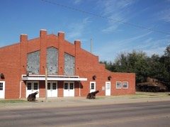 | Kingman National Guard Armory | building | 2004 | 04000666 |
 | Kingman Santa Fe Depot | building | 2001 | 01001091 |
| Charles M. Prather Barn | building | 2002 | 02001263 | |
 | US Post Office-Kingman | building | 1989 | 89001645 |
| Louis Werner Barn | building | 2020 | 100005952 |
Every wildfire the federal occurrence database records inside this county: 122 of them, burning about 7,751 acres. 2 started naturally and 4 were recorded as arson. Each settlement page carries the fires within five miles of it.
| Reported cause | Fires |
|---|---|
| Missing data/not specified/undetermined | 48 |
| Debris and open burning | 37 |
| Equipment and vehicle use | 13 |
| Smoking | 10 |
| Recreation and ceremony | 5 |
| Arson/incendiarism | 4 |
| Power generation/transmission/distribution | 2 |
| Natural | 2 |
| Misuse of fire by a minor | 1 |
The five largest, by the area the report gives. None of them was recorded as arson.
| Date | Cause | Size | Reported by | Name on the report |
|---|---|---|---|---|
| 15 April 2008 | Missing data/not specified/undetermined | 6,400 acres | Kansas Counties | PRATT SANDHILLS |
| 2 March 2017 | Missing data/not specified/undetermined | 360 acres | Kingman County | DRESDEN |
| 31 March 2015 | Debris and open burning | 160 acres | Kansas Forest Service | 3311 |
| 10 March 2015 | Debris and open burning | 100 acres | Kansas Forest Service | 3 |
| 20 March 2017 | Debris and open burning | 80 acres | Kingman County | 1454 |
| 20 March 2017 | Debris and open burning | 80 acres | Kingman County | 1455 |
| 15 April 2020 | Missing data/not specified/undetermined | 80 acres | Kansas Forest Service | not named |
| 16 February 2018 | Equipment and vehicle use | 50 acres | Kansas Forest Service | 39 |
Every settlement page carries the fires within five miles of it - see the settlement index below.
The NOAA Storm Events Database holds 766 reports for this county, causing no deaths, 5 injuries and about $3,901,050 in recorded property damage. Each settlement page carries the reports that name it.
| Kind of event | Reports |
|---|---|
| Hail | 398 |
| Thunderstorm Wind | 258 |
| Tornado | 66 |
| Flood | 17 |
| Heavy Rain | 13 |
| Flash Flood | 12 |
| Lightning | 2 |
The most serious of them, by death, then injury, then recorded damage. The accounts are quoted exactly as the forecast office filed them.
| When | Event | Place named | Harm | What the report says |
|---|---|---|---|---|
| September 2008 | Heavy Rain | Rago | 1 hurt, $5,000 | A vehicle traveling north, hit water standing on the roadway and lost control south of Rago on Kansas Highway 14. The driver of the car was injured when his left arm/elbow went through the drivers window. |
| December 1956 | Tornado (F0) | not stated | 1 hurt, $250 | no account filed |
| October 2017 | Thunderstorm Wind | Cunningham | 1 hurt | A Fed Ex truck was blown in to the median along Highway 54. The driver was transported to the hospital. There were also 8 power poles south of Cunningham blown over. |
| May 2008 | Thunderstorm Wind | Spivey | 1 hurt | Trees and tree limbs less than 4 inches in diameter were downed. One minor injury occurred in Spivey, but details are unknown. |
| October 1984 | Thunderstorm Wind | not stated | 1 hurt | no account filed |
| April 1996 | Thunderstorm Wind | Kingman | $800,000 | no account filed |
| July 1994 | Thunderstorm Wind | Norwich | $500,000 | Winds of 70 to 100 mph blew across the southeast part of the county. There was extensive tree damage. A large well-digging truck was blown over three miles west of Cheny with damage at $50 thousand. |
| April 1994 | Thunderstorm Wind | Kingman | $500,000 | Large trees were uprooted, a fence was blown through a garage, shingles were blown off a roof, and a chimney sustained damage from strong thunderstorm winds. |
| April 1968 | Tornado (F2) | not stated | $250,000 | no account filed |
| May 2010 | Lightning | Kingman | $150,000 | During the predawn hours of May 19th, lightning from a weakening area of showers and thunderstorms struck a residence in rural Kingman. The house was set ablaze. No injuries were incurred, but the century-old house was deemed a total loss by insurance adjusters. The Kingman Leader-Courier contributed to this article. |
| May 2010 | Tornado (EF2) | Rago | $125,000 | The tornado touched down and caused some damage to a barn and some trees limbs were partially torn off. As the tornado continued to move to the northeast more significant damage occurred. A house was damaged with the roof being torn off of a house with 2 exterior walls being blown out (EF2 damage). Two garages were also destroyed and a riding lawnmower was removed from the garage and moved 100 yards downstream. Three people took shelter from the tornado in the basement and were unharmed. |
| September 2018 | Flood | Kingman | $100,000 | A number of homes on the west side of Kingman were evacuated, along with several closed roads, due to flooding along the swollen Ninnescah River. |
| September 2000 | Thunderstorm Wind | Cunningham | $100,000 | A garage was blown down, the roof peeled from an office building resulting in the damaging of computers and other equipment inside, and tree damage was widespread. |
| June 2008 | Thunderstorm Wind | Cunningham | $94,000 | Ten power poles were blown down and 4 roofs were blow off of out buildings. Winds were estimated at 100 mph. Golf ball sized hail also was reported. |
| July 2003 | Tornado (F1) | Cunningham | $75,000 | Slow-moving, the tornado extensively damaged two farmsteads, one silo, and, of course, trees. |
| August 2011 | Thunderstorm Wind | Norwich | $70,000 | Law Enforcement reported around 30 power poles downed along K-42, with some more poles downed along 100th Avenue just north of K-42. This all occurred about 5 miles west of Norwich. Additionally, Emergency Management reported a few outbuildings damaged about 6 miles west of Norwich. |
| May 2010 | Hail | Kingman | $70,000 | Hail up to goflball size moved across the northwest portion of town. Fifty roofs were damaged by the hail, with 15 percent of those needing total replacement. |
| October 2018 | Flash Flood | Kingman Muni Arpt | $50,000 | Several rural roads around Kingman county were impassible due to high water. Rushing water eroded some of the culverts on county roads. |
| October 2018 | Flash Flood | Kingman | $50,000 | Flash flooding was reported on the south side if Kingman, where the Riverside Park flooded up to 4 feet deep due to high water and water from the Ninnescah River. |
| June 2006 | Thunderstorm Wind | Cunningham | $50,000 | Chaser reported via KSNW Television that strong winds caused damage in Cunningham, mostly in the form of downed tree limbs and minor structural damage. However, the 97-year old Ratcliff building received extensive damage to its exterior (courtesy of the Cunningham Courier). |
| April 1996 | Thunderstorm Wind | Norwich | $50,000 | no account filed |
| May 1993 | Hail | Penalosa | $50,000 | no account filed |
| August 2017 | Thunderstorm Wind | Kingman | $40,000 | Three to four power poles were snapped. |
| February 2012 | Thunderstorm Wind | Cleveland | $40,000 | Center pivot irrigation system was overturned. |
| August 2011 | Thunderstorm Wind | Norwich | $40,000 | Winds estimated around 80 mph overturned a central pivot irrigation system just south of Norwich. The Norwich News was the sole contributor to this report. |
| June 2006 | Thunderstorm Wind | Kingman | $40,000 | Approximately twenty utility poles were blown down in and around the Kingman area. Numerous tree limbs were also downed. Information courtesy of the Kingman Leader Courier. |
| May 2012 | Thunderstorm Wind | Kingman Muni Arpt | $37,500 | Five power poles were knocked down. |
| August 2013 | Thunderstorm Wind | Zenda | $30,000 | A trained spotter reported power poles knocked down. The spotter reported winds estimated at 60 mph with very heavy rainfall. |
| May 2012 | Thunderstorm Wind | Kingman Muni Arpt | $30,000 | Damage was reported to the airplane hangers at the Kingman Airport. |
| May 2011 | Lightning | Murdock | $30,000 | Lightning ignited a large oil tank reservoir several miles west of Cheney in rural Kingman county during the early evening hours on the 19th. Strong southeasterly winds hampered the firefighter's efforts, but they eventually extinguished the large fire later that evening. The Cheney Times-Sentinel contributed to this report. |
| June 1997 | Hail | Murdock | $30,000 | ONE HOME BADLY DAMAGED. |
| March 2002 | Thunderstorm Wind | Kingman | $25,000 | Power lines and power poles downed on west side of town along highway 54. |
| August 1998 | Thunderstorm Wind | Norwich | $25,000 | Trees and power lines blown down. |
| May 1955 | Tornado (F1) | not stated | $25,000 | no account filed |
| June 1953 | Tornado (F0) | not stated | $25,000 | no account filed |
| August 2017 | Thunderstorm Wind | Kingman Muni Arpt | $20,000 | Several power poles were knocked down from the severe gusts, estimated to be 65 mph. |
| April 2015 | Thunderstorm Wind | Mt Vernon | $20,000 | The emergency manager reported heavy damage to a boat and camper storage building. Several power lines were also knocked down. |
| July 2013 | Thunderstorm Wind | Norwich | $20,000 | A framed pole barn that was under construction was blown down. |
| July 2013 | Thunderstorm Wind | Norwich | $20,000 | A roof was blown off a 25 foot by 40 foot building. Trees and limbs were blown down across the area. |
| June 2008 | Thunderstorm Wind | Kingman Muni Arpt | $20,000 | The wind was measured by AWOS equipment at the Kingman Airport. The strong winds downed several power poles, power lines and tree limbs in and around the Kingman area. Information courtesy of the Kingman Leader-Courier Newspaper. |
| June 2008 | Hail | Cunningham | $18,000 | Golf ball sized hail was driven by estimated 100 mph winds. |
| June 2008 | Thunderstorm Wind | Cunningham | $18,000 | Several power poles were blown just south of Cunningham. |
| September 2016 | Thunderstorm Wind | Rago | $15,000 | Law enforcement reports three foot diameter cottonwood trees were blown down. |
| September 2016 | Thunderstorm Wind | Norwich | $15,000 | Law enforcement reported six diameter tree limbs were reported down at a farm. Shingles were reported off of the roof as well. |
| July 2013 | Thunderstorm Wind | Norwich | $15,000 | A shed was demolished. |
| July 2013 | Thunderstorm Wind | Norwich | $15,000 | Limbs 2 to 3 inches in diameter were blown down as were power lines and power poles. No power outages were reported. |
| August 2003 | Thunderstorm Wind | Kingman | $15,000 | Unspecified number of power poles and power lines downed. In addition, the severe thunderstorm winds lifted the east end of a metal pole shed, blowing the section over the roof. The damaged section was found in a pasture immediately west of the shed's location. Kingman Leader Courier contributed greatly to this narrative. |
| June 2002 | Thunderstorm Wind | Kingman | $15,000 | Several trees and power lines downed. |
| July 2013 | Thunderstorm Wind | Kingman | $10,000 | Limbs 8 inches in diameter were blown down, several of which landed on power lines. Several traffic signs were also blown down. |
| February 2012 | Thunderstorm Wind | Murdock | $10,000 | Power lines were downed. |
| May 2010 | Thunderstorm Wind | Norwich | $10,000 | Tree were reported down along Kansas Highway 42. |
| March 2009 | Hail | Kingman | $10,000 | The hail was one inch thick on Highway 54. This caused cars to slide off of the highway. |
| October 2007 | Thunderstorm Wind | Norwich | $10,000 | A Small barn was blown down. |
| May 2010 | Thunderstorm Wind | Rago | $6,000 | Some power poles were downed along Highway 42. |
| August 2017 | Thunderstorm Wind | Kingman | $5,000 | A tree 25 feet tall and two feet in diameter was snapped about 3 feet from the ground, from estimated 70 mph winds. |
| July 2013 | Thunderstorm Wind | Norwich | $5,000 | Limbs at least 2 inches in diameter were blown down along with large marble-sized hail. The event lasted at least 20 minutes. |
| July 2013 | Thunderstorm Wind | Murdock | $5,000 | Power lines were blown down across a road. |
| July 2011 | Thunderstorm Wind | Norwich | $5,000 | A metal building lost about half its roof, and also had the south side of the building pushed in. |
| August 2011 | Thunderstorm Wind | Rago | $5,000 | Two portable sheds approximately 10 miles south of Kingman on Highway 14 were thrown roughly 300-400 yards from winds estimated around 70 mph. The Norwich News was the sole contributor to this report. |
| June 2011 | Thunderstorm Wind | Murdock | $5,000 | Estimated gust reported by a trained spotter. A building that was being framed also collapsed. |
Named settlements recorded in the Geographic Names Information System, each with the topographic sheets covering it. Villages, hamlets and abandoned places alike. Each is shown with the nearest named watercourse or landform and the survey quadrangle it falls on.
Peters township · 67142 · On Peters Creek · Willowdale quadrangle
13 sheets, 1892 to 1985