 Block
From the record
28 National Register listings published here.
Sources: the National Register database, National Park Service
68 topographic sheets cover 19 settlements here, and 28 properties are on the National Register of Historic Places.
28 National Register listings published here.
Sources: the National Register database, National Park Service
Every property in this county listed on the National Register of Historic Places, with the year it was listed and the federal nomination document.
| Photograph | Property | Type | Listed | Reference |
|---|---|---|---|---|
 | 1927 Hillsboro Water Tower | structure | 2011 | 11000727 |
 | Amelia Park Bridge | structure | 2004 | 03001467 |
| Battey House | building | 2025 | 100012440 | |
 | Bethel School | building | 1987 | 87002114 |
 | Bichet School, District 34 | building | 2004 | 03001498 |
 | Bown-Corby School | building | 2015 | 15000146 |
 | Burns Union School | building | 1975 | 75000714 |
| Donaldson and Hosmer Building | building | 100005122 | ||
 | Doyle Place | building | 2000 | 98000266 |
 | Elgin Hotel | building | 1978 | 78001286 |
 | Florence Opera House | building | 2011 | 10001142 |
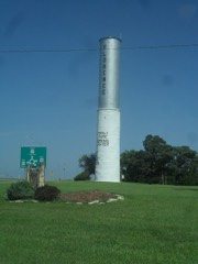 | Florence Water Tower | structure | 2009 | 09000275 |
 | Harvey House | building | 1973 | 73000763 |
 | Hill Grade School | building | 1976 | 76000827 |
 | Island Field Ranch House | building | 1995 | 95000579 |
| Keystone Ranch | district | 2017 | 100001290 | |
| Lost Springs | site | 1976 | 76000826 | |
 | Marion County Courthouse | building | 1976 | 76000828 |
| Marion County Park and Lake | district | 2002 | 02000607 | |
 | W. H. Morgan House | building | 1996 | 95001562 |
 | Old Peabody Library | building | 1973 | 73000765 |
 | Peabody City Park | site | 2012 | 11001032 |
 | Peabody Downtown Historic District | district | 1998 | 98000590 |
 | Peabody Township Carnegie Library | building | 1987 | 87000959 |
 | Pioneer Adobe House | building | 1973 | 73000764 |
| Santa Fe Trail-Marion County Trail Segments | site | 1995 | 95000584 | |
 | William F. and Ida G. Schaeffler House | building | 2002 | 02000490 |
 | J. S. Schroeder Building | building | 1991 | 91001770 |
Every wildfire the federal occurrence database records inside this county: 151 of them, burning about 9,264 acres. 4 started naturally and 5 were recorded as arson. Each settlement page carries the fires within five miles of it.
| Reported cause | Fires |
|---|---|
| Debris and open burning | 68 |
| Missing data/not specified/undetermined | 35 |
| Equipment and vehicle use | 28 |
| Smoking | 5 |
| Arson/incendiarism | 5 |
| Misuse of fire by a minor | 4 |
| Natural | 4 |
| Recreation and ceremony | 2 |
The five largest, by the area the report gives. None of them was recorded as arson.
| Date | Cause | Size | Reported by | Name on the report |
|---|---|---|---|---|
| 4 April 2016 | Missing data/not specified/undetermined | 3,200 acres | Marion County | TAMPA |
| 23 March 2014 | Missing data/not specified/undetermined | 1,500 acres | Kansas Forest Service | MN310-14005 |
| 6 March 2016 | Missing data/not specified/undetermined | 1,200 acres | Marion County | WAGON WHEEL |
| 11 March 2016 | Missing data/not specified/undetermined | 600 acres | Marion County | MARION UPLAND ROAD |
| 4 March 2020 | Missing data/not specified/undetermined | 250 acres | Kansas Forest Service | not named |
| 14 April 2020 | Recreation and ceremony | 220 acres | Kansas Forest Service | not named |
| 27 February 2016 | Equipment and vehicle use | 200 acres | Kansas Forest Service | 16014 |
| 20 February 2016 | Debris and open burning | 200 acres | Kansas Forest Service | 16013 |
Every settlement page carries the fires within five miles of it - see the settlement index below.
The NOAA Storm Events Database holds 709 reports for this county, causing 1 death, 20 injuries and about $47,812,030 in recorded property damage. Each settlement page carries the reports that name it.
| Kind of event | Reports |
|---|---|
| Hail | 340 |
| Thunderstorm Wind | 227 |
| Tornado | 55 |
| Flash Flood | 37 |
| Flood | 24 |
| Heavy Rain | 20 |
| Lightning | 4 |
| Funnel Cloud | 2 |
The most serious of them, by death, then injury, then recorded damage. The accounts are quoted exactly as the forecast office filed them.
| When | Event | Place named | Harm | What the report says |
|---|---|---|---|---|
| March 1990 | Tornado (F5) | not stated | 1 killed, $25,000,000 | no account filed |
| August 2010 | Thunderstorm Wind | Marion Res | 10 hurt, $40,000 | Extensive damage occurred at the Cottonwoon Point campground at Marion Lake. Three recreational vehicles were flipped over trapping a family of five and injuring 10 people overall. Most of the injuries were cuts and bruises, but one person had to be extricated from a camper and flown to a nearby hospital. 5 people that were taken to the hospital were treated and released. Trees were also knocked down with a carport destroyed. |
| April 1956 | Tornado (F3) | not stated | 2 hurt, $2,500,000 | no account filed |
| April 1964 | Tornado (F1) | not stated | 2 hurt, $2,500 | no account filed |
| July 1994 | Thunderstorm Wind | Marion | 2 hurt | no account filed |
| April 1956 | Tornado (F3) | not stated | 1 hurt, $2,500,000 | no account filed |
| April 1956 | Tornado (F3) | not stated | 1 hurt, $2,500,000 | no account filed |
| March 2006 | Tornado (F1) | Durham | 1 hurt, $70,000 | The tornado moved rapidly northeast, producing F1 damage at two farmsteads. Several outbuildings were damaged or destroyed. One person was injured (direct) while traveling on highway K-15, when the tornado rolled their vehicle several times. A semi loaded to 80,000 pounds, traveling directly behind the rolled van, also rolled onto its side. Thankfully, the driver was not injured. |
| August 2010 | Thunderstorm Wind | Tampa | 1 hurt, $5,000 | County dispatch reported a shed was destroyed and power lines down. |
| May 1990 | Tornado (F3) | not stated | $2,500,000 | no account filed |
| March 1990 | Tornado (F2) | not stated | $2,500,000 | no account filed |
| April 1956 | Tornado (F3) | not stated | $2,500,000 | no account filed |
| April 1956 | Tornado (F3) | not stated | $2,500,000 | no account filed |
| July 2001 | Lightning | Hillsboro | $1,500,000 | City of Hillsboro electrical and maintenance building was struck and considered a total loss. Time of occurrence is approximate. |
| July 1994 | Thunderstorm Wind | Durham | $500,000 | There was widespread damage to trees, small buildings and farm equipment across the county. In rural Ramona a 70 foot tall silo was knocked onto a granary shed, destroying a tractor that was inside. One thousand pound straw bales were tossed around. Two cattle were killed by lightning. |
| April 2009 | Thunderstorm Wind | Peabody | $300,000 | The strong winds moved a house off its foundation near the intersection of 140th and Mustang. Several residences sustained roof damage across the area, and there was some barn and outbuilding damage in the Aulne area. It is estimated that 3 homes and 30 outbuildings were damaged across the county. Additionally, a dozen or two power poles were downed, and some automobiles and farm equipment was damaged due to collapsed roofs. Countywide total property damage was likely around $300,000 to $400,000. The Marion County Record contributed to this report, as well as Marion County Emergency Management. |
| June 1992 | Tornado (F1) | not stated | $250,000 | no account filed |
| June 1990 | Tornado (F1) | not stated | $250,000 | no account filed |
| May 1971 | Tornado (F2) | not stated | $250,000 | no account filed |
| April 1956 | Tornado (F1) | not stated | $250,000 | no account filed |
| June 2014 | Thunderstorm Wind | Tampa | $150,000 | Numerous reports of wind damage between Tampa, Kansas, and Lost Springs, Kansas. Damage included power poles and five foot diameter trees blown down. Also numerous reports of shed and barn damage. |
| May 2019 | Flash Flood | Peabody | $100,000 | Peabody Police reported that residences south of Spring Creek had to be evacuated due to quickly rising water. |
| June 2010 | Flash Flood | Peabody | $100,000 | Early morning rainfall up to 6 inches inundated Spring Creek and Doyle Creek. The creeks rose so fast that 10 families had to be evacuated from their homes. All roads leading into Peabody from the south were impassible due to the flooding creeks. Two water rescues occurred when drivers tried to cross the high water. |
| June 2009 | Tornado (EF0) | Durham | $100,000 | Some tree damage with several power lines down. Two farmsteads were struck causing damage to several barns and feed bins. |
| May 1998 | Thunderstorm Wind | Marion | $100,000 | Minor damage sustained to boats and docks at Glen Elder Lake Marina, widespread tree damage, power lines downed. |
| October 1997 | Tornado (F0) | Pilsen | $100,000 | COMBINE FLIPPED ONTO IT'S SIDE AND ONE BARN RIPPED FROM IT'S FOUNDATION. |
| May 1999 | Tornado (F1) | Durham | $75,000 | Four outbuildings and two vehicles destroyed. |
| May 2019 | Flash Flood | Tampa | $60,000 | Three water rescues were reported in town along with numerous roads reported under water. |
| May 2019 | Flash Flood | Florence | $50,000 | Water was reported over the Florence bridge and portions of Florence were flooded. |
| May 2009 | Flood | Marion | $50,000 | Main street in Marion was flooded for a short time. Numerous county roads were flooded. |
| April 2009 | Thunderstorm Wind | Burns | $50,000 | Strong winds inflicted roof damage to both a residence and the Morton building. Some structural damage occurred to outbuildings, and some farm equipment was moved around. |
| April 2008 | Flash Flood | Durham | $50,000 | Slow moving thunderstorms produced very heavy rainfall amounts across primarily the northern half of Marion County from the mid-morning into the afternoon hours of April 23rd. Rainfall amounts exceeded 6 inches for some locations, with rainfall rates around 2 inches per hour at times. Hillsboro reported 4.96 inches, and Marion reported 5.36 inches. Widespread flooding occurred across mainly the northern half of Marion County, which prompted numerous road closures. Some roads were covered with nearly 6 feet of water. As a result, several roads and culverts sustained some form of damage, along with some county bridges. Especially hard hit was the town of Durham, when the North Cottonwood River backed up due to a 3.5-foot rise in the Marion Reservoir, flooding portions of the town with up to 18 inches of water. Some homes and businesses received flood damage. Some farmers from around the area stated they had never seen the Cottonwood River that high, although an older gentleman stated he had seen the river higher twice before, most notably in 1951. High water finally subsided by the morning hours of April 24th. Information courtesy of the Marion County Record and the Hillsboro Free Press. |
| May 2003 | Tornado (F0) | Burns | $50,000 | Trees uprooted, one of which possessed a 36 inch diameter trunk, and a second that fell onto a house. Power lines downed. Power poles leaning sharply. One out-building partially unroofed, with effected section of roof impaled into nearby building. |
| August 2001 | Lightning | Florence | $50,000 | Oil battery struck. After being extinguished, tank re-ignited explosively, setting fire to four nearby tanks. All five tanks were allowed to burn themselves out during the night when firefighters determined that fires wouldn't spread beyond the confines of the tanks. |
| March 2000 | Thunderstorm Wind | Tampa | $50,000 | Two 50 foot by 16 foot loafing sheds destroyed. |
| September 2000 | Thunderstorm Wind | Burns | $50,000 | At one residence, a 24 by 24 foot shed was blown over, one car damaged when a tree fell onto it, and shingles were blown off the roof of the house. A second house that was unconstruction sustained significant damage when when all but the south wall of the second floor were blown down and debris from construction material was blown about the area. A 3rd residence sustained damage when a tree fell through an upstairs bedroom wall. Several trees and power lines were blown down around the town. Area newspapers contributed to this report. |
| May 1999 | Tornado (F1) | Marion | $50,000 | Initial touchdown occurred over eastern Marion Reservoir at approximately 1535. Moving northeast at 30 kts, the tornado passed near Lincolnville and then just to the east of Lost Springs where it crossed into southwest Morris County. Extensive damage was inflicted upon one home just southeast of Lost Springs where the garage was destroyed and part of roof was lost. |
| June 1994 | Thunderstorm Wind | not stated | $50,000 | A severe thunderstorm packing winds up to 118 mph and hail up to baseball-size crossed over Marion County. The hardest hit areas were from Lehigh, where baseball-size hail fell, to Goesssel, where winds reached 60 knots then to Hillsboro and down to Peabody, where winds blew up to 60 mph. Some wheat fields were flattened, signs were blown down, trees were heavily damaged, and some mobile homes were damaged. Fallen trees broke windows. In Goessel the winds tore off three-quarters of a mobile home's roof and tossed it 100 yards and another that stored school supplies lost all of its roof. In Goessell damage was estimated between $35,000 to $40,000. |
| June 2006 | Thunderstorm Wind | Hillsboro | $40,000 | A powerful thunderstorm produced extensive damage throughout the town of Hillsboro. Numerous large trees were uprooted, utility poles were downed, and street signs were blown over. Consequently, much of the town lost power. Fortunately, structural damage was relatively light, with the exception of three large umbrella-shaped canopies destroyed at the Hillsboro Family Aquatic Center. Information courtesy of the Hillsboro Star newspaper. |
| April 2011 | Hail | Burns | $32,500 | Multiple residences had windows broken out of their homes from ping pong ball to golfbal size hail. The hail lasted almost 10 minutes. |
| July 2019 | Flash Flood | Durham | $30,000 | Emergency management reported evacuations occurred in the town of Durham due to rapidly rising water along the Cottonwood river. |
| August 2013 | Thunderstorm Wind | Hillsboro | $30,000 | Law enforcement reports large trees down. The KSN weather lab at Marion High School reported a wind gust to 57 mph. |
| October 2007 | Thunderstorm Wind | Lost Spgs | $26,000 | A machine shed was destroyed by straight line winds. The structure measured 54 feet by 72 feet. Five large evergreen trees were also broken off, with one uprooted. |
| September 2019 | Hail | Goessel | $25,000 | A delayed report was received of tennis ball-sized hail that dented vehicles and cracked a windshield. The report was received via Twitter. The time of the event was estimate based on radar. |
| June 2001 | Thunderstorm Wind | Burns | $25,000 | Barn blown down. |
| May 1971 | Tornado (F1) | not stated | $25,000 | no account filed |
| June 1953 | Tornado (F0) | not stated | $25,000 | no account filed |
| June 1953 | Tornado (F2) | not stated | $25,000 | no account filed |
| June 2010 | Flood | Goessel | $20,000 | Numerous low water crossings became impassible due to heavy rainfall during the early morning hours. Rainfall amounts ranged from 2.53 inches in Goessel to 4.22 inches in Hillsboro. The flooding caused 42 campsites to close around Marion Reservoir. The flooding also caused a temporary wooden bridge, southwest of Marion, 4 feet wide by 14 feet long, used for pipeline construction, to wash out and be carried downstream into a wooded area. |
| June 2006 | Thunderstorm Wind | Marion | $20,000 | A powerful thunderstorm produced widespread tree and some structural damage in and around the town of Marion. In Marion, the roof of a metal building was blown off, causing additional damage to nearby cars and businesses. Also, a roof on a building near the city's water tower was blown off. Information courtesy of the Marion County Record newspaper. |
| May 1998 | Thunderstorm Wind | Peabody | $20,000 | Widespread tree damage and a windmill blown over. |
| June 2009 | Thunderstorm Wind | Goessel | $18,000 | The winds caused damage to a barn and nearby trees. |
| February 2012 | Thunderstorm Wind | Hillsboro | $15,000 | Winds estimated around 80 mph damaged a handful of farmsteads just west of Hillsboro. Outbuildings were heavily damaged or destroyed, windows were broken, trees were uprooted and limbs snapped. Information courtesy of the Peabody Gazette-Bulletin. |
| June 2009 | Thunderstorm Wind | Marion Res | $15,000 | The 60 mph winds destroyed a barn at a home along Jade Road. The storm also stripped trees of leaves and damaged corn plants. Some wheat damage also occurred. |
| July 2009 | Thunderstorm Wind | Lost Spgs | $15,000 | Three-quarters of a barn roof along Highway 77 was torn off. |
| April 2008 | Hail | Hillsboro | $15,000 | Ten to fifteen minutes of dime to nickel size hail caused some scattered, mostly minor roof damage across Hillsboro. However, one business's tar roof was possibly totaled, along with a broken skylight. |
| April 2006 | Thunderstorm Wind | Florence | $15,000 | A repair shop suffered extensive damage when its metal roof blew off. Pieces of the roof were strewn about one quarter mile east of the property. Additionally, an outbuilding on the same property suffered moderate damage. |
| July 2023 | Thunderstorm Wind | Lehigh | $10,000 | The emergency manager reported a barn had collapsed. Additionally a tree fell onto a house creating a hole in the roof. |
| August 2011 | Thunderstorm Wind | Goessel | $10,000 | Several 6 to 9 inch tree limbs were blown down and several powerlines as well. |
| April 2010 | Thunderstorm Wind | Peabody | $10,000 | A roof was blown off a building at the Peabody Golf Course. A power pole was also downed. |
The Survey's mineral resources record lists 2 workings inside this county. All of them still produce. Each settlement page carries the workings within five miles of it.
| Commodity | Workings |
|---|---|
| Stone, Crushed/Broken | 2 |
The least common of them first, because a county's hundredth gravel pit says nothing its first ten did not.
| Where | Site | Commodity | Status | Recorded |
|---|---|---|---|---|
| Marion Quarry #81g | Stone, Crushed/Broken | Producer | ||
| Sunflower Quarry & Mill | Stone, Crushed/Broken | Producer |
Named settlements recorded in the Geographic Names Information System, each with the topographic sheets covering it. Villages, hamlets and abandoned places alike. Each is shown with the nearest named watercourse or landform and the survey quadrangle it falls on.
Clear Creek township · 66858 · On East Branch Clear Creek · Lincolnville quadrangle
12 sheets, 1898 to 1985