 Block
From the record
9 National Register listings published here.
Sources: the National Register database, National Park Service
27 topographic sheets cover 11 settlements here, and 9 properties are on the National Register of Historic Places.
9 National Register listings published here.
Sources: the National Register database, National Park Service
Every property in this county listed on the National Register of Historic Places, with the year it was listed and the federal nomination document.
| Photograph | Property | Type | Listed | Reference |
|---|---|---|---|---|
| Agra Consolidated School | building | 2005 | 05001246 | |
| Agra Lake and Park | site | 2008 | 08000616 | |
| Battle Creek King Post Truss Bridge | structure | 2003 | 03000362 | |
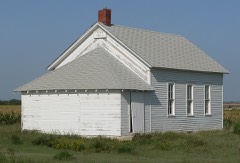 | Hoff School District No. 42 | building | 2011 | 10001140 |
| Jack Creek Kingpost | structure | 1990 | 89002188 | |
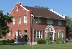 | Kirwin City Hall | building | 2006 | 06000471 |
 | Long Island School | building | 2005 | 05000551 |
 | Phillipsburg Community Building | building | 2010 | 10000845 |
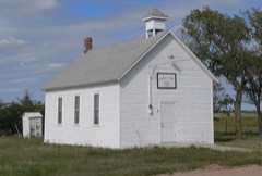 | Pleasant Ridge Church | building | 2005 | 05001204 |
Every wildfire the federal occurrence database records inside this county: 51 of them, burning about 4,228 acres. 6 started naturally and none was recorded as arson. Each settlement page carries the fires within five miles of it.
| Reported cause | Fires |
|---|---|
| Missing data/not specified/undetermined | 12 |
| Recreation and ceremony | 11 |
| Equipment and vehicle use | 8 |
| Natural | 6 |
| Debris and open burning | 6 |
| Smoking | 5 |
| Power generation/transmission/distribution | 2 |
| Fireworks | 1 |
The five largest, by the area the report gives. None of them was recorded as arson.
| Date | Cause | Size | Reported by | Name on the report |
|---|---|---|---|---|
| 27 June 2012 | Missing data/not specified/undetermined | 2,250 acres | Kansas Counties | HIGHWAY9 |
| 18 November 2005 | Debris and open burning | 289 acres | Kirwin National Wildlife Refuge | DOG TOWN SOUTH |
| 1 May 2011 | Debris and open burning | 240 acres | Kirwin National Wildlife Refuge | LOSEY |
| 28 April 2007 | Recreation and ceremony | 200 acres | Kirwin National Wildlife Refuge | DELMAR HALL |
| 13 March 2007 | Missing data/not specified/undetermined | 182 acres | Kirwin National Wildlife Refuge | BOR |
| 19 April 2004 | Debris and open burning | 168 acres | Kirwin National Wildlife Refuge | UNIT 9 |
| 8 July 2001 | Debris and open burning | 135 acres | Kirwin National Wildlife Refuge | LAWYER-U21 |
| 4 April 2006 | Debris and open burning | 126 acres | Kirwin National Wildlife Refuge | BLUEGILL |
Every settlement page carries the fires within five miles of it - see the settlement index below.
The NOAA Storm Events Database holds 585 reports for this county, causing no deaths, 4 injuries and about $16,213,060 in recorded property damage. Each settlement page carries the reports that name it.
| Kind of event | Reports |
|---|---|
| Hail | 328 |
| Thunderstorm Wind | 183 |
| Tornado | 40 |
| Flash Flood | 14 |
| Heavy Rain | 10 |
| Flood | 5 |
| Funnel Cloud | 4 |
| Lightning | 1 |
The most serious of them, by death, then injury, then recorded damage. The accounts are quoted exactly as the forecast office filed them.
| When | Event | Place named | Harm | What the report says |
|---|---|---|---|---|
| July 1984 | Thunderstorm Wind | not stated | 2 hurt | no account filed |
| May 1985 | Tornado (F4) | not stated | 1 hurt, $2,500,000 | no account filed |
| June 2000 | Thunderstorm Wind | Long Is | 1 hurt, $1,000,000 | no account filed |
| May 1985 | Tornado (F4) | not stated | $2,500,000 | no account filed |
| June 2000 | Hail | Long Is | $1,000,000 | no account filed |
| July 2023 | Hail | Phillipsburg | $500,000 | Hail up to the size of ping pong balls was reported in the Phillipsburg area. |
| July 2023 | Hail | Phillipsburg | $500,000 | no account filed |
| July 2024 | Hail | Phillipsburg | $250,000 | Hail up to golf ball size reported in and around Phillipsburg. Emergency management reported their vehicle had a broken windshield. |
| July 2024 | Thunderstorm Wind | Phillipsburg | $250,000 | A wind gust of 68 MPH was measured by a mesonet station located two miles west-southwest of Phillipsburg. Emergency management reported downed tree limbs in town, including a few up to 10 inches in diameter. |
| August 2014 | Hail | Agra | $250,000 | Hail ranging in size from golf balls to softballs was reported. |
| April 1991 | Tornado (F1) | not stated | $250,000 | no account filed |
| March 1983 | Tornado (F1) | not stated | $250,000 | no account filed |
| September 2015 | Hail | Speed | $200,000 | Hail reaching the size of baseballs resulted in significant damage to vehicles and homes in the area. Numerous windows and windshields were damaged or destroyed. There was extensive crop damage. Tree limbs up to 5 inches in diameter were downed, but an estimated wind speed was not available. |
| September 2015 | Hail | Prairie View | $200,000 | Hail up to the size of golf balls resulted in vehicle damage. |
| July 2008 | Hail | Prairie View | $200,000 | no account filed |
| October 2017 | Hail | Agra | $150,000 | Hail ranging in size from half dollars to baseballs was reported. |
| October 2017 | Hail | Kirwin | $150,000 | Hail up to the size of golf balls was reported. A portion of Highway 9 east of Glade was covered with 1-2 inches of hail. |
| April 2005 | Flash Flood | Countywide | $150,000 | no account filed |
| May 2004 | Thunderstorm Wind | Phillipsburg | $150,000 | no account filed |
| June 2000 | Hail | Logan | $150,000 | no account filed |
| July 2024 | Hail | Phillipsburg | $125,000 | A wind gust of 61 MPH was measured by a trained spotter. Wind was accompanied by quarter to golf ball size hail. |
| July 2024 | Thunderstorm Wind | Phillipsburg | $125,000 | A wind gust of 61 MPH was measured by a trained spotter. Wind was accompanied by quarter to golf ball size hail. |
| July 2024 | Thunderstorm Wind | Agra | $125,000 | Wind gusts were estimated to be near 60 MPH. Crop damage was reported from the combination of wind and hail of unknown size. |
| June 2014 | Thunderstorm Wind | Phillipsburg | $125,000 | A line of thunderstorms with damaging wind gusts generally in the 60 to 80 MPH range, but including an 86 MPH gust measured by the Phillipsburg Airport AWOS at 10:37 p.m. CDT, moved across Phillips County. A sustained wind speed of 67 MPH was also recorded by the AWOS. This wind was accompanied by large hail of unknown size, which resulted in windows being broken out of a vehicle in Phillipsburg. Numerous trees were damaged, with some being uprooted, and large limbs were downed. |
| April 2001 | Tornado (F0) | Phillipsburg | $125,000 | no account filed |
| May 2024 | Flash Flood | Long Is | $100,000 | Radar estimates and local reports showed that between 2 and 5 inches of rain fell across the area. Emergency management reported the Deer Creek was out of its banks west of Phillipsburg, and that several rural roads across the area were either covered in water or had swift water running over them at one time and had to be closed. Some fencing was damaged at a farmstead by flood waters west of Glade and north of Highway 9. A local disaster declaration was made by emergency management. |
| July 2024 | Hail | Long Is | $100,000 | Quarter to golf ball size hail was reported in this area. |
| August 2023 | Hail | Long Is | $100,000 | Hail up to the size of half dollars was accompanied by wind gusts estimated to be near 60 MPH. |
| August 2023 | Thunderstorm Wind | Long Is | $100,000 | Wind gusts estimated to be near 60 MPH was accompanied by hail up to the size of half dollars. |
| June 2011 | Tornado (EF1) | Long Is | $100,000 | This tornado moved into northwest Phillips County approximately 5 miles west of Long Island, after affecting the Almena area in Norton County, shifting to the northeast before lifting approximately 4 miles northwest of Long Island. A few farm outbuildings sustained damage. |
| October 2007 | Hail | Phillipsburg | $100,000 | Hail up to the size of golf balls covered the ground for a time. |
| April 2003 | Heavy Rain | Phillipsburg | $100,000 | Torrential rainfall of 3 to 7 inches fell in northern Phillips county and washed out culverts and small bridges on rural roads. |
| June 2024 | Hail | Woodruff | $100,000 | no account filed |
| July 2024 | Hail | Prairie View | $100,000 | no account filed |
| June 2022 | Hail | Speed | $100,000 | no account filed |
| June 2022 | Hail | Glade | $100,000 | no account filed |
| May 2012 | Hail | Logan | $100,000 | no account filed |
| June 2005 | Hail | Phillipsburg | $100,000 | no account filed |
| July 2004 | Thunderstorm Wind | Phillipsburg | $100,000 | no account filed |
| July 2004 | Hail | Kirwin | $100,000 | no account filed |
| June 2000 | Hail | Agra | $100,000 | no account filed |
| August 1998 | Hail | Logan | $100,000 | no account filed |
| August 1998 | Hail | Phillipsburg | $100,000 | no account filed |
| May 2013 | Tornado (EF1) | Prairie View | $80,000 | This tornado touched down approximately 1 mile south of Prairie View and was on the ground for a couple minutes before lifting just outside the southeast edge of town. This EF1 rated tornado had a maximum wind speed estimated to be 90 mph and a maximum width of 40 yards. Damage from this tornado was primarily confined to one farmstead, with 3 outbuildings being damaged or destroyed, tree damage with limbs up of 6 to 8 inches in diameter being broken and the home sustained window damage. |
| September 2016 | Flash Flood | Logan | $75,000 | Storm total rainfall amounts of 3 to 5 inches of rain were reported. Emergency management reported that numerous county roads were covered in water, as was portions of Highway 9 in the Logan area. Though the flash flood threat waned, flooding along the North Fork of the Solomon River continued on for a couple days due to very heavy rainfall upstream of Phillips County. |
| September 2016 | Flood | Logan | $75,000 | Very heavy rain fell over the southern half of Norton County, the northern half of Graham County and far western portions of Phillips County during the late night hours of September 3rd and into the morning of the 4th. The runoff from this rain resulted in major flooding of the North Fork Solomon River. The river gauge located just south of Glade was above flood stage of 11 feet for almost 48 hours, and a new record crest occurred with a stage of 18.55 feet at 1:45 a.m. CST on September 5th. Area roads already affected by flash flooding during the early morning hours of the 4th saw no relief as the water upstream passed through, and a Labor Day event in the town of Logan was cancelled due to area road conditions. |
| May 2012 | Hail | Glade | $75,000 | The south side of an area home had all of its windows broken. |
| May 2012 | Hail | Kirwin | $75,000 | Hail ranging from golf ball to baseball size was reported. |
| May 2007 | Tornado (EF1) | Phillipsburg | $75,000 | The storm initially caused damage at the Phillipsburg airport to the windsock and supporting bracket. It then moved NNW resulting in damage to the western parts of the town. It is believed that the initial damage was due to straight-line winds from the airport to just east of the swimming pool (West H Street and West Park Street). At that point, evidence of a tornado was ascertained with damage continuing for approximately one-quarter mile. The width of the tornado damage was narrow, ranging from 30 to 75 yards. The tornado was rated EF-0 at the initial point of touchdown, and then increased to EF-1 near the intersection of Oak and West E Streets. The tornado damaged a few rooftops, a childrens outdoor play set, fencing, and broke a few windows. A few trees were uprooted near the Robinson Greenhouse. |
| June 2010 | Flash Flood | Kirwin | $75,000 | no account filed |
| July 1996 | Lightning | Logan | $75,000 | no account filed |
| July 2023 | Hail | Long Is | $50,000 | Hail up to the size of golf balls was reported in the area. |
| July 2023 | Thunderstorm Wind | Kirwin Res | $50,000 | A wind gust of 75 MPH was measured by a RAWS located four miles west of Kirwin and by a mesonet station located two miles south-southwest of Kirwin. Tree damage was reported in the area, including limbs around eight inches in diameter being downed. |
| May 2022 | Hail | Logan | $50,000 | Hail up to the size of golf balls was reported along this path. |
| May 2017 | Thunderstorm Wind | Phillipsburg | $50,000 | Severe criteria wind gusts, peaking at 71 MPH, were measured just south of Phillipsburg. In town, a restaurant lost its roof. Power lines and large tree limbs, some 6-12 inches in diameter, were downed. |
| May 2008 | Flash Flood | Long Is | $50,000 | Thunderstorms dumped heavy rains of 3 to 5 inches across this area. This caused several creeks to go out of their banks and many rural roads were flooded. |
| July 2008 | Hail | Stuttgart | $50,000 | Hail was reported on Highway 36. |
| June 2008 | Hail | Phillipsburg | $50,000 | Hail reported to be covering the ground and accompanied by estimated 50 mph winds. |
| May 2008 | Flash Flood | Agra | $50,000 | Thunderstorms rumbled across northern Kansas and dumped several inches of rain across Phillips County. This caused several rural roads and area creeks and streams to flood. |
| July 2024 | Hail | Phillipsburg | $50,000 | no account filed |
The Survey's mineral resources record lists 1 working inside this county. It still produces. Each settlement page carries the workings within five miles of it.
| Commodity | Workings |
|---|---|
| Sand and Gravel, Construction | 1 |
The least common of them first, because a county's hundredth gravel pit says nothing its first ten did not.
| Where | Site | Commodity | Status | Recorded |
|---|---|---|---|---|
| Siebert Glade Sand Pit | Sand and Gravel, Construction | Producer |
Named settlements recorded in the Geographic Names Information System, each with the topographic sheets covering it. Villages, hamlets and abandoned places alike. Each is shown with the nearest named watercourse or landform and the survey quadrangle it falls on.
Phillipsburg city · 67661 · On Plotner Creek · Phillipsburg North quadrangle
13 sheets, 1893 to 1985
Mound township · 67661 · On Starvation Creek · Stuttgart quadrangle
13 sheets, 1893 to 1985