 Block
From the record
7 National Register listings published here.
Sources: the National Register database, National Park Service
37 topographic sheets cover 7 settlements here, and 7 properties are on the National Register of Historic Places.
7 National Register listings published here.
Sources: the National Register database, National Park Service
Every property in this county listed on the National Register of Historic Places, with the year it was listed and the federal nomination document.
| Photograph | Property | Type | Listed | Reference |
|---|---|---|---|---|
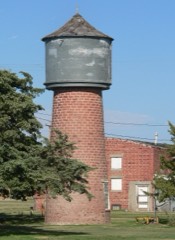 | Collyer Downtown Historic District | building | 2010 | 09001207 |
| Keraus Hardware Store | building | 2023 | 100009418 | |
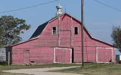 | Lipp Barn | building | 2009 | 09000501 |
| St. Michael School & Convent | building | 2008 | 08000310 | |
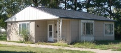 | Stradal House | building | 2001 | 01000193 |
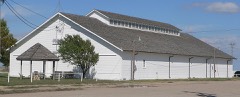 | Trego County Fairgrounds Exhibit Building | building | 2004 | 03001500 |
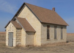 | Wilcox School-District 29 | building | 2006 | 06000393 |
Every wildfire the federal occurrence database records inside this county: 25 of them, burning about 215 acres. 5 started naturally and none was recorded as arson. Each settlement page carries the fires within five miles of it.
| Reported cause | Fires |
|---|---|
| Missing data/not specified/undetermined | 13 |
| Natural | 5 |
| Equipment and vehicle use | 3 |
| Debris and open burning | 3 |
| Smoking | 1 |
The five largest, by the area the report gives. None of them was recorded as arson.
| Date | Cause | Size | Reported by | Name on the report |
|---|---|---|---|---|
| 30 September 2017 | Debris and open burning | 45 acres | Trego County | 017-052 |
| 14 October 2020 | Missing data/not specified/undetermined | 40 acres | Kansas Forest Service | not named |
| 1 May 2020 | Missing data/not specified/undetermined | 20 acres | Kansas Forest Service | not named |
| 29 November 2016 | Missing data/not specified/undetermined | 20 acres | Kansas Forest Service | 016-057 |
| 26 March 2020 | Missing data/not specified/undetermined | 12 acres | Kansas Forest Service | not named |
| 10 February 2017 | Missing data/not specified/undetermined | 10 acres | Trego County | 017-008 |
| 9 May 2018 | Natural | 10 acres | Kansas Forest Service | 018-024 |
| 9 March 2018 | Missing data/not specified/undetermined | 10 acres | Kansas Forest Service | 018-011 |
Every settlement page carries the fires within five miles of it - see the settlement index below.
The NOAA Storm Events Database holds 643 reports for this county, causing 5 deaths, 101 injuries and about $8,895,030 in recorded property damage. Each settlement page carries the reports that name it.
| Kind of event | Reports |
|---|---|
| Hail | 410 |
| Thunderstorm Wind | 134 |
| Tornado | 61 |
| Heavy Rain | 28 |
| Flash Flood | 8 |
| Flood | 2 |
The most serious of them, by death, then injury, then recorded damage. The accounts are quoted exactly as the forecast office filed them.
| When | Event | Place named | Harm | What the report says |
|---|---|---|---|---|
| June 1951 | Tornado (F4) | not stated | 5 killed, 100 hurt, $2,500,000 | no account filed |
| May 1959 | Tornado (F1) | not stated | 1 hurt | no account filed |
| June 2005 | Tornado (F1) | Ogallah | $3,000,000 | Three semi-trucks were rolled when the tornado crossed Interstate 70 east of Ogallah. One U.S. mail truck rolled twice. |
| April 1990 | Tornado (F3) | not stated | $2,500,000 | no account filed |
| May 1985 | Tornado (F3) | not stated | $250,000 | no account filed |
| June 1974 | Tornado (F2) | not stated | $250,000 | no account filed |
| May 1971 | Tornado (F2) | not stated | $250,000 | no account filed |
| May 1998 | Hail | Trego Center | $25,000 | All of the west windows broken out of a house. The hail was part of a swath 7 miles wide that tracked along a line from the Gove county border from section 19-14-25 to the southeast corner of the county. Over 50,000 acres of native grass were mowed down. |
| June 1969 | Tornado (F3) | not stated | $25,000 | no account filed |
| April 1954 | Tornado (F2) | not stated | $25,000 | no account filed |
| June 1951 | Tornado (F1) | not stated | $25,000 | no account filed |
| October 1998 | Tornado (F1) | Riga | $15,000 | Tornado marched on into Ellis county, producing a 26 mile long path. |
| May 1995 | Hail | Trego Center | $10,000 | Nearly $2 million damage to crops occurred across the county. |
| July 1996 | Thunderstorm Wind | Trego Center | $8,000 | no account filed |
| July 1996 | Thunderstorm Wind | Wakeeney | $3,000 | no account filed |
| June 1954 | Tornado | not stated | $2,500 | no account filed |
| June 2000 | Thunderstorm Wind | Trego Center | $2,000 | Camper was overturned but there were no injuries. Location was at Cedar Bluff reservoir. |
| July 1999 | Thunderstorm Wind | Trego Center | $2,000 | Four inch diameter limbs blown down. Shingles blown off roof. |
| May 2007 | Thunderstorm Wind | Trego Center | $1,500 | A hay shed was knocked over by the high wind. |
| August 1997 | Thunderstorm Wind | Wakeeney | $1,000 | A few power poles blown down. |
| June 1978 | Tornado (F0) | not stated | $30 | no account filed |
| September 2025 | Hail | Collyer | - | A social media report of 1 inch hail. |
| September 2025 | Hail | Wakeeney | - | Trego county emergency manager reported quarter sized hail 3 W of Wakeeney. |
| June 2025 | Heavy Rain | Trego Center | - | A report of 1.88 inches of rain was received through CocoRahs. |
| August 2025 | Flash Flood | Trego Center | - | The emergency manager reported flash flooding and washed out roads, with hay bales carried by the water into the road, near Page Creek Bridge. Time estimated via radar and flood guidance. |
| May 2025 | Hail | Ogallah | - | A storm chaser reported 1 inch hail. |
| June 2025 | Heavy Rain | Trego Center | - | A report of 2.34 inches of rainfall was reported through Cocorahs. |
| July 2025 | Hail | Collyer | - | Quarter size hail was reported by the public. |
| June 2024 | Thunderstorm Wind | Voda | - | Half of a large tree down on home. |
| June 2024 | Thunderstorm Wind | Wakeeney | - | Wind report of 60 mph. |
| July 2024 | Thunderstorm Wind | Cedar Bluff Res | - | Strong thunderstorm wind gusts were measured by mesonet station. |
| July 2024 | Thunderstorm Wind | Riga | - | Nickel Hail reported by the public. |
| September 2024 | Flash Flood | Collyer | - | From 8 miles south of Collyer, social media reports of multiple roads flooded including 4 feet of water over the Trego County road O near the Trego/Gove County line road. |
| September 2024 | Hail | Collyer | - | Social media reports included multiple pictures of 2-2.25 inch hail stones. |
| May 2023 | Heavy Rain | Riga | - | NWS rain gauge storm total rainfall 2.30 inches. |
| July 2023 | Thunderstorm Wind | Wakeeney | - | Strong winds. |
| July 2023 | Thunderstorm Wind | Ogallah | - | Strong winds. |
| July 2023 | Thunderstorm Wind | Ogallah | - | Wind gusts were estimated between 65 and 70 mph. |
| April 2022 | Thunderstorm Wind | Wakeeney | - | Mesonet site 1 SSW Wakeeney. |
| September 2022 | Hail | Wakeeney | - | The report was from mPing. |
| September 2022 | Hail | Wakeeney | - | The report was from mPing. |
| June 2021 | Thunderstorm Wind | Wakeeney | - | Winds were estimated to be 60 to 70 MPH. |
| March 2021 | Heavy Rain | Wakeeney | - | Rainfall of 4.50 inches was observed. |
| August 2021 | Heavy Rain | Riga | - | Rainfall of 7.50 was measured. |
| July 2020 | Heavy Rain | Riga | - | Rainfall of 2.52 inches was observed. |
| July 2020 | Heavy Rain | Riga | - | Rainfall of 2.61 inches was observed. |
| August 2020 | Hail | Cedar Bluff Res | - | Hail covered the ground. |
| April 2019 | Thunderstorm Wind | Trego Center | - | Winds were estimated to be 60 to 70 MPH. |
| April 2019 | Thunderstorm Wind | Collyer | - | Winds were estimated to be 60 to 70 MPH. |
| August 2019 | Thunderstorm Wind | Voda | - | Winds were estimated to be 70 MPH. |
| August 2019 | Thunderstorm Wind | Wakeeney | - | A roof was blown off a building. |
| August 2019 | Hail | Cedar Bluff Res | - | The hail lasted about 10 minutes. |
| June 2018 | Thunderstorm Wind | Trego Center | - | Winds were estimated to be 65 MPH. |
| June 2018 | Heavy Rain | Collyer | - | Rainfall of 4.26 inches was measured. |
| September 2018 | Thunderstorm Wind | Trego Center | - | Four to six inch diameter tree branches were broken by the high wind. |
| July 2018 | Thunderstorm Wind | Trego Center | - | Winds were estimated to be 60 MPH. |
| May 2018 | Heavy Rain | Wakeeney | - | Rainfall of 4.10 was measured in two hours and at the time of the observation it was still raining. |
| May 2018 | Heavy Rain | Voda | - | Rainfall of 5.20 inches was observed and it was still raining at the time of the observation. |
| May 2018 | Thunderstorm Wind | Wakeeney | - | Severe semi trucks were overturned by the high wind. |
| May 2018 | Flood | Wakeeney | - | Water and debris came across the road. |
The Survey's mineral resources record lists 2 workings inside this county. All of them still produce. Each settlement page carries the workings within five miles of it.
| Commodity | Workings |
|---|---|
| Sand and Gravel, Construction | 2 |
The least common of them first, because a county's hundredth gravel pit says nothing its first ten did not.
| Where | Site | Commodity | Status | Recorded |
|---|---|---|---|---|
| Siebert Sand Pit & Plant No.1b | Sand and Gravel, Construction | Producer | ||
| Wiles Sand Pit | Sand and Gravel, Construction | Producer |
Named settlements recorded in the Geographic Names Information System, each with the topographic sheets covering it. Villages, hamlets and abandoned places alike. Each is shown with the nearest named watercourse or landform and the survey quadrangle it falls on.