 Block
From the record
7 National Register listings published here, 1 of them a National Historic Landmark.
Sources: the National Register database, National Park Service
35 topographic sheets cover 18 settlements here, and 7 properties are on the National Register of Historic Places.
7 National Register listings published here, 1 of them a National Historic Landmark.
Sources: the National Register database, National Park Service
Every property in this county listed on the National Register of Historic Places, with the year it was listed and the federal nomination document.
| Photograph | Property | Type | Listed | Reference |
|---|---|---|---|---|
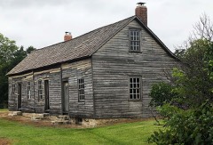 | Hollenberg Pony Express Station | building | 1966 | 66000352 |
| Lowe Center School-District 115 | building | 2014 | 14000119 | |
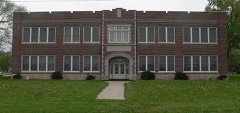 | Mahaska Rural High School #3 | building | 2007 | 07000604 |
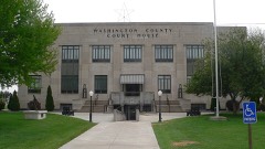 | Washington County Courthouse | building | 2000 | 00000328 |
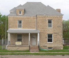 | Washington County Jail and Sheriff's Residence | building | 1996 | 96000762 |
| Washington County Kingpost | structure | 1990 | 89002184 | |
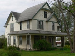 | John F. Wayland House | building | 2013 | 13000222 |
Every wildfire the federal occurrence database records inside this county: 50 of them, burning about 724 acres. 2 started naturally and 2 were recorded as arson. Each settlement page carries the fires within five miles of it.
| Reported cause | Fires |
|---|---|
| Debris and open burning | 26 |
| Missing data/not specified/undetermined | 13 |
| Equipment and vehicle use | 6 |
| Natural | 2 |
| Arson/incendiarism | 2 |
| Smoking | 1 |
The five largest, by the area the report gives. None of them was recorded as arson.
| Date | Cause | Size | Reported by | Name on the report |
|---|---|---|---|---|
| 10 March 2015 | Debris and open burning | 180 acres | Kansas Forest Service | 3102015 |
| 7 March 2017 | Missing data/not specified/undetermined | 100 acres | Washington County | 17798 |
| 7 April 2020 | Debris and open burning | 100 acres | Kansas Forest Service | not named |
| 12 October 2015 | Equipment and vehicle use | 80 acres | Kansas Forest Service | 10 |
| 9 September 2017 | Debris and open burning | 60 acres | Washington County | 6 |
| 9 March 2017 | Debris and open burning | 30 acres | Washington County | 392017 |
| 8 March 2017 | Debris and open burning | 20 acres | Washington County | 382017 |
| 27 December 2016 | Equipment and vehicle use | 20 acres | Kansas Forest Service | 17 |
Every settlement page carries the fires within five miles of it - see the settlement index below.
The NOAA Storm Events Database holds 615 reports for this county, causing 2 deaths, 12 injuries and about $28,361,830 in recorded property damage. Each settlement page carries the reports that name it.
| Kind of event | Reports |
|---|---|
| Hail | 393 |
| Thunderstorm Wind | 163 |
| Tornado | 36 |
| Flash Flood | 13 |
| Flood | 5 |
| Lightning | 4 |
| Funnel Cloud | 1 |
The most serious of them, by death, then injury, then recorded damage. The accounts are quoted exactly as the forecast office filed them.
| When | Event | Place named | Harm | What the report says |
|---|---|---|---|---|
| September 1973 | Tornado (F3) | not stated | 2 killed, 6 hurt, $25,000,000 | no account filed |
| April 1991 | Tornado (F2) | not stated | 6 hurt, $250,000 | no account filed |
| April 2006 | Tornado (F2) | Barnes | $750,000 | This tornado touched down at 420pm cst 5 miles north of Barnes and was on the ground for 17 miles before crossing the state line into Gage County, Nebraska 3.5 miles east-northeast of Hollenberg, Kansas...or about 3 miles south and 0.5 miles west of Odell, Nebraska. It was caused by a supercell thunderstorm and was sighted by many storm chasers and storm spotters. Most of the damage with this tornado was rated as F0 or F1. However, strong F2 damage was noted near the intersection of Highways 36 and 148, where one brick home had the roof torn off and some of the exterior walls knocked down. The occupants of the home were in the basement and had to be helped from the damaged home by emergency personel. Four outbuildings were also damaged at this location. Elsewhere, the tornado caused damage to one other home and five additional outbuildings as well as many trees, and one home was completely destroyed just southeast of Hanover. |
| May 2007 | Flood | Washington | $600,000 | Moderate or greater flooding on Mill Creek immediate reach of gage vicinity of Washington. Flood damage to county and township roads, bridges, culverts, solid waste department and rural water district. |
| July 1994 | Thunderstorm Wind | Hanover | $500,000 | Severe thunderstorm winds blew down 15 telephone poles and did extensive damage to trees and farm outbuildings. |
| May 1996 | Tornado (F2) | Vining | $300,000 | no account filed |
| April 1991 | Tornado (F3) | not stated | $250,000 | no account filed |
| May 1966 | Tornado (F3) | not stated | $250,000 | no account filed |
| May 2002 | Tornado (F0) | Mahaska | $75,000 | A tornado touched down in Mahaska and produced considerable damage to homes and buildings. |
| June 1998 | Tornado (F1) | Hollenburg | $55,000 | no account filed |
| June 2005 | Flash Flood | Washington | $50,000 | At least 6 inches of fast flowing water across roads around Washington. |
| July 1994 | Thunderstorm Wind | Haddam | $50,000 | Severe thunderstorm winds blew down a pump house and did extensive tree damage. |
| August 1996 | Lightning | Washington | $30,000 | no account filed |
| November 1973 | Tornado (F1) | not stated | $25,000 | no account filed |
| July 2007 | Flash Flood | Palmer | $20,000 | Six-inch deep water reported to be flowing across Hwy 9. |
| August 1997 | Tornado (F0) | Greenleaf | $15,000 | no account filed |
| June 1998 | Tornado (F0) | Hanover | $12,000 | no account filed |
| April 2026 | Flood | Washington | $10,000 | A local county road is closed due to flooding. |
| June 2009 | Tornado (EF1) | Hanover Arpt | $10,000 | The first visible sign of a tornado was located 4.5 miles north |of Hanover, near the intersection of 27th and zenith road in |Washington county. The tornado snapped two power poles, one |snapped at the base and another at midpoint, near the Washington |and Marshall county line along 27th road where it exited Washington County at around 13:26 LST. The tornado then tracked into Marshall County at 27th and county line road and damaged several tree branches along its path into Marshall County. |
| August 1997 | Thunderstorm Wind | Hanover | $10,000 | no account filed |
| April 2001 | Tornado (F1) | Washington | $9,000 | A tornado touched down near Washington and moved northeast . The tornado damaged outbuildings, an antenna, and power poles before dissipating 2 miles north of Washington. |
| May 2002 | Hail | Mahaska | $8,000 | Large hail broke windows and damaged roofs and buildings. |
| April 2001 | Thunderstorm Wind | Mahaska | $6,000 | Thunderstorm winds damaged 2 buildings. |
| May 2006 | Flash Flood | Washington | $5,000 | Up to 4.65 inches of rain in less than 2 hours brought up to six inches of fast flowing water across U.S. highway 36 just west of Washington. |
| May 2005 | Flash Flood | Hanover | $5,000 | Torrential rains of 5 to 6 inches brought fast flowing water of at least 6 inches across Kansas highway 148. |
| April 2001 | Tornado (F0) | Haddam | $5,000 | A tornado touched down over open country and damaged trees and some outbuildings before dissipating near the Nebraska border. |
| April 2001 | Thunderstorm Wind | Hollenburg | $5,000 | Thunderstorm winds blew the roof off a barn. |
| April 2001 | Thunderstorm Wind | Haddam | $5,000 | Strong thunderstorm winds damaged a house. |
| July 1994 | Thunderstorm Wind | Barnes | $5,000 | Significant tree damage was caused by thunderstorm winds. |
| July 1994 | Thunderstorm Wind | Munden | $5,000 | Severe thunderstorm winds blew down a pump house and did extensive tree damage. |
| July 1994 | Thunderstorm Wind | Morrowville | $5,000 | no account filed |
| July 1994 | Thunderstorm Wind | Washington | $5,000 | no account filed |
| July 1994 | Hail | Linn | $5,000 | no account filed |
| July 2000 | Lightning | Washington | $3,000 | Lightning struck the Law enforcement center in Washington causing about 50 percent of the equipment to be severely damaged. |
| September 1999 | Lightning | Hanover | $3,000 | Lightning struck a residence and did minor damage. |
| May 1983 | Tornado (F0) | not stated | $2,500 | no account filed |
| May 1959 | Tornado (F1) | not stated | $2,500 | no account filed |
| May 2010 | Thunderstorm Wind | Greenleaf | $2,000 | A total of 4 outbuildings were destroyed at this location as a result of a strong wind gust. |
| June 2010 | Thunderstorm Wind | Morrowville | $2,000 | Trained spotters and Law enforcement officers reported 70 to 80 mph wind gusts across Washington County. In Washington numerous trees were uprooted, which brought down several power lines. |
| April 2001 | Thunderstorm Wind | Washington | $2,000 | Strong thunderstorm winds blew windows out of a house. |
| June 1998 | Thunderstorm Wind | Hanover | $2,000 | no account filed |
| July 2012 | Thunderstorm Wind | Kimeo | $1,000 | A two foot diameter Locust tree was snapped half way up from the base. Elsewhere near Linn a few maple trees had 12 inch limbs broken. |
| June 2010 | Thunderstorm Wind | Strawberry | $1,000 | A 6 inch diameter tree limb snapped in Clifton. In Barnes a trained spotter reported an estimated 70 mph wind gust. |
| May 2005 | Flash Flood | Washington | $1,000 | Heavy rains brought over 6 inches of fast flowing water over roads in the area. |
| June 1994 | Hail | Hanover | $500 | no account filed |
| June 1994 | Hail | Hanover | $500 | no account filed |
| June 1994 | Hail | Washington | $500 | no account filed |
| June 1994 | Hail | Washington | $500 | no account filed |
| June 1994 | Hail | Morrowville | $500 | no account filed |
| May 1993 | Hail | Linn | $500 | no account filed |
| September 1993 | Hail | Kimeo | $500 | no account filed |
| September 1993 | Hail | Kimeo | $500 | no account filed |
| September 1993 | Hail | Barnes | $500 | no account filed |
| May 1983 | Tornado (F0) | not stated | $250 | no account filed |
| May 1994 | Hail | Hollenburg | $50 | no account filed |
| June 1983 | Tornado (F0) | not stated | $30 | no account filed |
| August 2025 | Thunderstorm Wind | Barnes | - | Personal weather station. |
| May 2024 | Hail | Morrowville | - | Half dollar size hail, also estimating 50 mph winds. |
| May 2024 | Thunderstorm Wind | Washington | - | Estimated 60 mph winds. |
| May 2024 | Hail | Washington | - | Report from mping. |
Named settlements recorded in the Geographic Names Information System, each with the topographic sheets covering it. Villages, hamlets and abandoned places alike. Each is shown with the nearest named watercourse or landform and the survey quadrangle it falls on.
Mill Creek township · 66958 · On Salt Creek · Morrowville quadrangle
13 sheets, 1893 to 1985