 Block
From the record
One of 12 National Register listings published here for Ellsworth County · listed in 2004 · category: District.
Sources: the National Register database, National Park Service
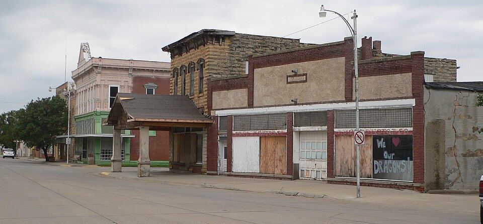
Listed on the National Register of Historic Places in 2004.
One of 12 National Register listings published here for Ellsworth County · listed in 2004 · category: District.
Sources: the National Register database, National Park Service
Regional context, not property-specific evidence. The federal wildfire occurrence database lists 9 fires within 5 miles of Wilson Downtown Historic District #1-Main St. between 2006 and 2018, burning about 5,128 acres in total. None started naturally. None was recorded as arson. Distance is straight-line from the map coordinates, so a fire counted here may appear on a neighbouring settlement's page as well.
| Reported cause | Fires |
|---|---|
| Missing data/not specified/undetermined | 7 |
| Debris and open burning | 1 |
| Equipment and vehicle use | 1 |
The most recent of them, most recent first, with the day each was reported and the service that recorded it.
| Date | Cause | Size | Reported by | Name on the report |
|---|---|---|---|---|
| 13 September 2015 | Missing data/not specified/undetermined | 1.0 acres | Kansas Forest Service | 30 |
| 30 July 2006 | Missing data/not specified/undetermined | 3,200 acres | Kansas Counties | MILE 208 |
| 24 July 2015 | Equipment and vehicle use | 1.0 acres | Kansas Forest Service | 25 |
| 27 June 2012 | Missing data/not specified/undetermined | 1,920 acres | Kansas Counties | DORRANCE |
| 7 March 2017 | Debris and open burning | under an acre | Ellsworth County | 11 |
| 18 March 2018 | Missing data/not specified/undetermined | 1.0 acres | Kansas Forest Service | 8 |
| 11 November 2016 | Missing data/not specified/undetermined | under an acre | Kansas Forest Service | 25 |
| 20 October 2015 | Missing data/not specified/undetermined | 2.0 acres | Kansas Forest Service | 35 |
Regional context, not property-specific evidence. The National Weather Service names Wilson, the town this property stands in, in 66 storm reports between 1995 and 2024: 35 hail, 23 thunderstorm wind, 3 tornado, 3 flash flood. No death or injury is recorded in these reports. Each account below is quoted exactly as the forecast office filed it, from the NOAA Storm Events Database, and each date opens the federal record of that event.
| When | Event | Place named | Harm | What the report says |
|---|---|---|---|---|
| June 2002 | Hail | Wilson | $500,000 | Numerous windows smashed out of homes, businesses and vehicles. Crop damage, especially to corn and wheat, was extensive. Area newspapers contributed greatly to this report. |
| June 2002 | Thunderstorm Wind | Wilson | $500,000 | Major roof damage, with some roofs completely blown off homes. Windows blown out off both homes and vehicles. In cases where roofs were blown off homes, the resultant water damage from rains was extensive. Area newspapers contributed greatly to this report. |
| May 2007 | Flash Flood | Wilson | $350,000 | Low water crossings were closed around Wilson due to high water. Widespread flooding was reported across the county. 2.55 inches of rain was reported by the Ellsworth police in just a few hours. No damage was reported to any structures. |
| August 2006 | Thunderstorm Wind | Wilson | $90,000 | Reports of tractor trailers being blown over on Interstate 70 near mile marker 206. |
| June 1995 | Hail | Wilson | $22,000 | Twenty to thirty percent of wheat crop was damaged. |
| May 2018 | Thunderstorm Wind | Wilson | $20,000 | The Kansas Highway Patrol reported that a semi had jack knifed on Interstate 70 due to the strong winds. |
| June 1995 | Hail | Wilson | $4,000 | no account filed |
| October 2018 | Flood | Wilson | $100 | Water was reported over the road just south of Wilson. |
| August 2013 | Flash Flood | Wilson | $100 | High water caused the closing of old Highway 40 between Ellsworth and Wilson due to water over the road. Numerous rural roads were impassible due to high water. Highway 14 north of Ellsworth also closed due to high water. |
| May 2024 | Tornado (EF0) | Wilson | - | A pivot system was flipped to the north on the south side of I-70 and to the south on the north side of I-70. A KDOT sign was also twisted. |
| May 2024 | Flood | Wilson | - | Water was over the roadway at Interstate 70 and 6th Road. |
| September 2021 | Thunderstorm Wind | Wilson | - | Law Enforcement reported the gust. |
| June 2020 | Hail | Wilson | - | Report via KSN television station of pea to ping pong ball sized hail. Time is approximated from radar. . |
| August 2020 | Thunderstorm Wind | Wilson | - | A large tree branch was blown down. |
| May 2018 | Hail | Wilson | - | Reported at mile marker 206 on Interstate 70. |
| July 2016 | Thunderstorm Wind | Wilson | - | This report was relayed via Law Enforcement. |
| September 2015 | Hail | Wilson | - | The hail was reported along Interstate 70. |
| May 2011 | Tornado (EF0) | Wilson | - | The tornado touched down briefly in open country. |
| May 2011 | Thunderstorm Wind | Wilson | - | Winds were estimated around 60 mph. |
| June 2011 | Thunderstorm Wind | Wilson | - | Estimated gust reported by a trained spotter. |
| July 2009 | Hail | Wilson | - | The hail nearly covered the ground. |
| July 2009 | Hail | Wilson | - | Dime to quarter size hail was reported just south of I-70 between Dorrance and Wilson. |
| June 2008 | Hail | Wilson | - | Hail ranged from pea to quarter size driven by 50 mph winds. |
| May 2007 | Tornado (EF0) | Wilson | - | Brief touchdown in open country. |
| August 2007 | Flash Flood | Wilson | - | Avenue J and L were closed due to high water flowing over them. 3.25 inches of rain was reported in the town of Wilson. |
| May 2006 | Thunderstorm Wind | Wilson | - | The spotter also reported pea size hail. |
| June 2002 | Hail | Wilson | - | Cooperative observer. |
| June 2002 | Hail | Wilson | - | Cooperative observer. |
| June 2002 | Hail | Wilson | - | No reports of damage, but one has to wonder. |
| June 1999 | Thunderstorm Wind | Wilson | - | Windows blown out of a home. |
| May 2024 | Hail | Wilson | - | no account filed |
| May 2024 | Hail | Wilson | - | no account filed |
| July 2024 | Thunderstorm Wind | Wilson | - | no account filed |
| June 2011 | Hail | Wilson | - | no account filed |
| June 2011 | Hail | Wilson | - | no account filed |
| September 2009 | Hail | Wilson | - | no account filed |
| April 2009 | Hail | Wilson | - | no account filed |
| June 2008 | Hail | Wilson | - | no account filed |
| June 2008 | Hail | Wilson | - | no account filed |
| September 2008 | Hail | Wilson | - | no account filed |
| June 2008 | Thunderstorm Wind | Wilson | - | no account filed |
| May 2006 | Thunderstorm Wind | Wilson | - | no account filed |
| August 2006 | Thunderstorm Wind | Wilson | - | no account filed |
| August 2006 | Thunderstorm Wind | Wilson | - | no account filed |
| August 2006 | Thunderstorm Wind | Wilson | - | no account filed |
| April 2005 | Hail | Wilson | - | no account filed |
| May 2004 | Hail | Wilson | - | no account filed |
| June 2004 | Thunderstorm Wind | Wilson | - | no account filed |
| June 2004 | Hail | Wilson | - | no account filed |
| September 2004 | Hail | Wilson | - | no account filed |
| June 2002 | Hail | Wilson | - | no account filed |
| April 2001 | Hail | Wilson | - | no account filed |
| April 2001 | Hail | Wilson | - | no account filed |
| June 2001 | Hail | Wilson | - | no account filed |
| July 2000 | Hail | Wilson | - | no account filed |
| June 2000 | Thunderstorm Wind | Wilson | - | no account filed |
| June 2000 | Thunderstorm Wind | Wilson | - | no account filed |
| June 2000 | Thunderstorm Wind | Wilson | - | no account filed |
| May 1999 | Hail | Wilson | - | no account filed |
| May 1998 | Hail | Wilson | - | no account filed |
No historic map-sheet match is published for this property yet. That does not mean no map exists. This record needs a coordinate-quality review before it can be joined to a sheet boundary. Browse the county's mapped places while that work is pending.
Other National Register properties close enough to walk or drive between, ordered by distance from this one. Both positions come from the same geocoding pass that matched these properties to their map sheets.
| Photograph | Property | Distance | Listed |
|---|---|---|---|
 | Midland Hotel | under 500 feet | 2002 |
| Wilson Downtown Historic District #3-Southside | under 500 feet | 2004 | |
 | Weinhold House | 0.4 miles | 2001 |
| National Archives record | The nomination case file for reference 03001496 in Record Group 79. |
| Ellsworth County | All 12 listed properties in this county. |