 Block
From the record
One of 2 National Register listings published here for Scott County · listed in 2005 · category: Building.
Sources: the National Register database, National Park Service
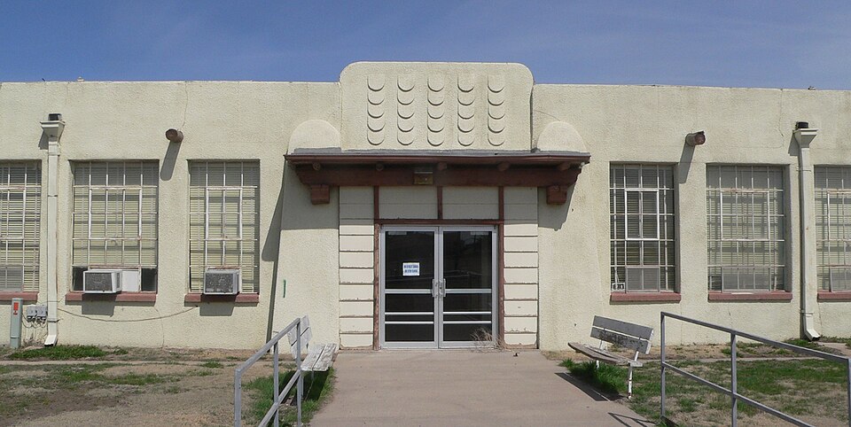
Listed on the National Register of Historic Places in 2005.
One of 2 National Register listings published here for Scott County · listed in 2005 · category: Building.
Sources: the National Register database, National Park Service
Regional context, not property-specific evidence. The National Weather Service names Shallow Water, the town this property stands in, in 86 storm reports between 1993 and 2025: 53 hail, 25 thunderstorm wind, 8 tornado. The reports record 1 death and 1 injury. Each account below is quoted exactly as the forecast office filed it, from the NOAA Storm Events Database, and each date opens the federal record of that event.
| When | Event | Place named | Harm | What the report says |
|---|---|---|---|---|
| April 2015 | Thunderstorm Wind | Shallow Water | 1 killed, 1 hurt | A severe thunderstorm passing to the north brought high wind on the south side. A 61 year old male was killed when his modular home was overturned and destroyed by the high wind. |
| April 2010 | Tornado (EF1) | Shallow Water | $210,000 | This wedge tornado was witnessed by storm chasers and spotters and damaged several barns, sheds and 2 pivot irrigation sprinklers. |
| May 2010 | Thunderstorm Wind | Shallow Water | $15,000 | Several power poles were broken, trees were toppled over, barn doors were blown off and a grain bin was collapsed by the high wind. |
| September 2025 | Thunderstorm Wind | Shallow Water | - | A mesonet site reported a 62 mph wind gust. |
| July 2025 | Thunderstorm Wind | Shallow Water | - | Measured by a mesonet station. |
| July 2025 | Hail | Shallow Water | - | One inch diameter hail was reported by the public. |
| July 2024 | Thunderstorm Wind | Shallow Water | - | Strong thunderstorm wind gusts were measured by mesonet stations. |
| August 2021 | Thunderstorm Wind | Shallow Water | - | Wind gusts to 60 MPH were reported. |
| September 2017 | Hail | Shallow Water | - | Most of the hail was smaller than quarter sized. |
| May 2016 | Tornado (EF0) | Shallow Water | - | This tornado initially developed in northern Kearny County at 19:10 CST before moving into Wichita County and finally in Scott County as it was weakening and moving east. |
| May 2016 | Tornado (EF1) | Shallow Water | - | A pivot irrigation sprinkler was damaged by the tornado. |
| April 2015 | Tornado (EF0) | Shallow Water | - | This was one of four landspout tornadoes that occurred concurrently. |
| April 2015 | Tornado (EF0) | Shallow Water | - | This was one of four landspout tornadoes that were occurring concurrently. |
| July 2015 | Thunderstorm Wind | Shallow Water | - | Winds were estimated to be 60 MPH. |
| May 2015 | Tornado (EF0) | Shallow Water | - | This tornado appeared to be relatively weak and short lived. |
| June 2014 | Thunderstorm Wind | Shallow Water | - | A cattle truck was blown into the ditch. |
| July 2014 | Thunderstorm Wind | Shallow Water | - | Winds were estimated to be 60 to 70 MPH. |
| May 2013 | Hail | Shallow Water | - | The hail varied in size from pea to ping pong ball. |
| April 2010 | Thunderstorm Wind | Shallow Water | - | The off duty employee estimated the wind gusts to 65 mph. |
| July 2010 | Thunderstorm Wind | Shallow Water | - | This was from a Ham radio station. |
| July 2010 | Thunderstorm Wind | Shallow Water | - | This report was from a Ham radio weather station. |
| April 2010 | Thunderstorm Wind | Shallow Water | - | This wind gust was measured at a ham radio station site. |
| April 2010 | Tornado (EF0) | Shallow Water | - | This tornado quickly became a rain wrapped wedge but again there was very little for it to damage in the sparsely populated area. |
| July 2010 | Thunderstorm Wind | Shallow Water | - | A semi was blown off highway 83 1 mile south of the Scott/Finney county line. Torrential rainfall was also reported. |
| July 2010 | Thunderstorm Wind | Shallow Water | - | Two to three inch diameter tree branches were broken by the high wind. |
| May 2010 | Thunderstorm Wind | Shallow Water | - | One semi was blown over on highway 83. |
| May 2010 | Hail | Shallow Water | - | The hail lasted 20 minutes. |
| July 2009 | Thunderstorm Wind | Shallow Water | - | The resident estimated the winds were 60 mph. |
| April 2003 | Hail | Shallow Water | - | The hail completely covered the ground. |
| April 2001 | Hail | Shallow Water | - | Also had 50 mph wind with the hail. |
| May 2001 | Thunderstorm Wind | Shallow Water | - | Three inch tree limbs blown down. |
| July 2000 | Thunderstorm Wind | Shallow Water | - | Irrigation sprinkler destroyed. |
| May 2024 | Hail | Shallow Water | - | no account filed |
| August 2021 | Hail | Shallow Water | - | no account filed |
| July 2020 | Hail | Shallow Water | - | no account filed |
| June 2020 | Hail | Shallow Water | - | no account filed |
| August 2019 | Hail | Shallow Water | - | no account filed |
| August 2019 | Hail | Shallow Water | - | no account filed |
| May 2018 | Hail | Shallow Water | - | no account filed |
| June 2017 | Hail | Shallow Water | - | no account filed |
| September 2017 | Thunderstorm Wind | Shallow Water | - | no account filed |
| May 2015 | Hail | Shallow Water | - | no account filed |
| May 2015 | Hail | Shallow Water | - | no account filed |
| June 2014 | Hail | Shallow Water | - | no account filed |
| July 2014 | Hail | Shallow Water | - | no account filed |
| August 2014 | Thunderstorm Wind | Shallow Water | - | no account filed |
| June 2013 | Hail | Shallow Water | - | no account filed |
| July 2013 | Hail | Shallow Water | - | no account filed |
| July 2013 | Hail | Shallow Water | - | no account filed |
| July 2013 | Hail | Shallow Water | - | no account filed |
| July 2013 | Hail | Shallow Water | - | no account filed |
| October 2011 | Hail | Shallow Water | - | no account filed |
| April 2010 | Hail | Shallow Water | - | no account filed |
| August 2010 | Hail | Shallow Water | - | no account filed |
| May 2010 | Hail | Shallow Water | - | no account filed |
| June 2008 | Hail | Shallow Water | - | no account filed |
| June 2008 | Hail | Shallow Water | - | no account filed |
| June 2008 | Hail | Shallow Water | - | no account filed |
| May 2008 | Hail | Shallow Water | - | no account filed |
| May 2008 | Hail | Shallow Water | - | no account filed |
No historic map-sheet match is published for this property yet. That does not mean no map exists. This record needs a coordinate-quality review before it can be joined to a sheet boundary. Browse the county's mapped places while that work is pending.
| National Archives record | The nomination case file for reference 05000553 in Record Group 79. |
| Scott County | All 2 listed properties in this county. |