 Block
From the record
One of 30 National Register listings published here for Montgomery County · listed in 2006 · category: Building.
Sources: the National Register database, National Park Service

Listed on the National Register of Historic Places in 2006.
One of 30 National Register listings published here for Montgomery County · listed in 2006 · category: Building.
Sources: the National Register database, National Park Service
Regional context, not property-specific evidence. The federal wildfire occurrence database lists 85 fires within 5 miles of Cook's Hotel between 2015 and 2020, burning about 308 acres in total. None started naturally. 4 were recorded as arson. Distance is straight-line from the map coordinates, so a fire counted here may appear on a neighbouring settlement's page as well.
| Reported cause | Fires |
|---|---|
| Debris and open burning | 45 |
| Missing data/not specified/undetermined | 25 |
| Equipment and vehicle use | 6 |
| Arson/incendiarism | 4 |
| Smoking | 4 |
| Fireworks | 1 |
The most recent of them, most recent first, with the day each was reported and the service that recorded it.
| Date | Cause | Size | Reported by | Name on the report |
|---|---|---|---|---|
| 23 September 2017 | Equipment and vehicle use | 1.0 acres | Montgomery County | 1740195 |
| 21 September 2017 | Equipment and vehicle use | under an acre | Montgomery County | 1730028 |
| 4 August 2017 | Debris and open burning | under an acre | Montgomery County | 1460 |
| 19 August 2020 | Missing data/not specified/undetermined | 1.0 acres | Kansas Forest Service | not named |
| 7 July 2017 | Arson/incendiarism | under an acre | Montgomery County | 1259 |
| 5 July 2015 | Fireworks | under an acre | Kansas Forest Service | 1086 |
| 4 July 2015 | Missing data/not specified/undetermined | under an acre | Kansas Forest Service | 1510072 |
| 3 July 2018 | Missing data/not specified/undetermined | under an acre | Kansas Forest Service | 1394 |
Regional context, not property-specific evidence. The federal mineral resources record lists 2 workings within 5 miles of Cook's Hotel: 2 producers. All of them still produce. What was taken out: Clay, Stone, Crushed/Broken. Distance is straight-line from the map coordinates, so a quarry counted here may appear on a neighbouring settlement's page as well.
| Where | Site | Commodity | Status | Recorded |
|---|---|---|---|---|
| Independence Clay Pit | Clay | Producer | ||
| Independence Limestone Cement Plant | Stone, Crushed/Broken | Producer |
Regional context, not property-specific evidence. The National Weather Service names Independence, the town this property stands in, in 155 storm reports between 1993 and 2026: 56 hail, 54 thunderstorm wind, 23 flash flood, 11 flood. No death or injury is recorded in these reports. Each account below is quoted exactly as the forecast office filed it, from the NOAA Storm Events Database, and each date opens the federal record of that event.
| When | Event | Place named | Harm | What the report says |
|---|---|---|---|---|
| June 1998 | Hail | Independence | $1,000,000 | Wind-driven hail smashed windows and inflicted considerable damage to roofs and vehicles. |
| June 1998 | Thunderstorm Wind | Independence | $1,000,000 | Numerous trees blown over, inflicting damage to at least 3 houses. Nine utilitiy poles blown over, severing power to numerous residences. |
| May 2007 | Flash Flood | Independence | $350,000 | Water rescue performed southwest of Independence. Flooding was reported across the county. |
| August 2006 | Thunderstorm Wind | Independence | $200,000 | A severe thunderstorm produced extensive power pole and tree damage across primarily western portions of Independence. An estimated 80 power poles were damaged or downed along a five-mile stretch on Peter Pan Road, knocking out power to an estimated 6,500 customers. Shortly after the storm, several motorists were stranded between the downed electrical lines and poles. Highways 160 and 75 through Independence were closed through the 26th due to the downed poles and lines. Information courtesy of the Independence Daily Reporter. |
| April 2015 | Hail | Independence | $50,000 | A viewer on FOX23, out of Tulsa reported hail to the size of grapefruit. |
| July 1994 | Thunderstorm Wind | Independence | $50,000 | The western and southern sections of the county received the brunt of the damaging winds from the large complex that traveled across central Kansas. Ninety mph winds damaged buildings at the Independence Airport. In Coffeyville, over 100 mph winds damaged roofs, signs and store windows as well as toppled trees. An entire metal shed was lifted from a yard and dropped over a fence into a neighboring yard. |
| May 1993 | Hail | Independence | $50,000 | no account filed |
| August 2019 | Flash Flood | Independence | $40,000 | Some street flooding occurred across Independence, stalling a few cars. |
| September 2009 | Flash Flood | Independence | $30,000 | Heavy rainfall of 4 to 6 inches in a 24 hour period caused flooding of numerous streets and county roads in and around Indepedence. The flooding caused portions of Highway 160 and 75 to be closed going through town. One water rescue was reported from a stalled vehicle. |
| August 2003 | Lightning | Independence | $25,000 | Unspecified number of power poles struck, severing power to 1,073 residences. By approximately 10AM the following morning, power had been restored to all but 61 residences. Times of incidents approximate. Narrative courtesy of the Parsons Sun. |
| May 2008 | Flash Flood | Independence | $20,000 | Two water rescues were conducted in Coffeyville while many city roads were closed in Independence due to high water. |
| February 2012 | Thunderstorm Wind | Independence | $10,000 | Winds estimated around 65 mph affected Independence. Damage was sporadic in town, with a large tree reported on a house, and a destroyed shed. Ping pong ball size hail accompanied the severe winds. The Independence Daily Reporter contributed to this report. |
| June 1996 | Thunderstorm Wind | Independence | $10,000 | no account filed |
| April 2019 | Thunderstorm Wind | Independence | $5,000 | The law enforcement reported that a 43-52 knot gust downed 2 power poles in town. |
| April 2006 | Thunderstorm Wind | Independence | $5,000 | A house sustained some structural damage due to severe straight line winds. |
| August 2003 | Lightning | Independence | $5,000 | Two homes struck. In the first, and more serious case, part of the home was set ablaze, with fire apparently spreading from the basement, up thru a laundry chute, then into the walls and attic of the home. The roof was also damaged, with most damage occurring toward the back of the home. Approximately six hours were required to extinguish the fire.In the second case, wiring was struck, igniting a small fire. Damage estimate: $100. Independence Daily contributed greatly to this narrative. |
| July 2002 | Thunderstorm Wind | Independence | $5,000 | Trees and power lines downed. |
| March 1993 | Hail | Independence | $5,000 | A thunderstorm dropped 0.75-inch hail briefly south of Independence. Little damage resulted. |
| May 1993 | Hail | Independence | $5,000 | no account filed |
| April 2011 | Thunderstorm Wind | Independence | $1,000 | A KWCH-TV storm chaser reported 5 to 6 inch diameter tree limbs down. |
| June 2008 | Thunderstorm Wind | Independence | $1,000 | Several 3 to 4 inch diameter tree limbs downed north of Independence. |
| April 1994 | Thunderstorm Wind | Independence | $500 | Golf ball-size hail also fell. |
| April 1994 | Hail | Independence | $500 | no account filed |
| April 2011 | Thunderstorm Wind | Independence | $200 | A trained weather spotter reported 8 inch diameter tree limbs down. |
| May 2009 | Flood | Independence | $200 | Two to four inches of rainfall caused flooding of county roads throughout the county including some low water crossings. |
| July 2021 | Flash Flood | Independence | $100 | Several roads in and around Independence, especially those near Whiskey creek had water over them and were closed during the flooding. |
| July 2021 | Flood | Independence | $100 | Up to 3 inches of rain feel near Whiskey Creek which produced some flooding. A few roads were also closed. |
| May 2020 | Flash Flood | Independence | $100 | Several rural roads were flooded across the county. In the town of Independence, Whiskey Creek flooded areas near several homes along North 19th and 15th streets. It was reported that 2 feet of water was surrounding the homes. |
| April 2016 | Flood | Independence | $100 | Six to eight inches of water flowed over Laurel and Hackney Roads. Also low land flooding was noted on both sides of town. |
| October 2016 | Flash Flood | Independence | $100 | Water was reported flowing over Pennsylvania Avenue on the south side of Independence. |
| October 2016 | Flash Flood | Independence | $100 | Water was flowing over south 10th street near Rock creek. |
| August 2013 | Flood | Independence | $100 | Numerous county roads had water over them. |
| April 1994 | Hail | Independence | $50 | no account filed |
| January 2026 | Thunderstorm Wind | Independence | - | Powerlines and power poles were down across the city. In addition, several outbuildings were damaged. A semi trailer was blown over as well. Entry door windows were broken and part of a roof was peeled off of a church. |
| May 2025 | Thunderstorm Wind | Independence | - | Wind gusts were estimated to be around 60 mph. Powerlines and multiple tree limbs were down across the city of Independence. A possible structure fire was potentially started by a downed power line. |
| February 2024 | Heavy Rain | Independence | - | This is a 24 hour rainfall total of 1.62 inches. There was one accident which occurred during this time frame that could be partially attributed to this event. No apparent injuries were reported. |
| April 2024 | Tornado (EFU) | Independence | - | Two photos of the tornado were shared via social media. No damage was reported. |
| June 2024 | Flood | Independence | - | Law enforcement reports street flooding in the city of Independence. |
| August 2024 | Thunderstorm Wind | Independence | - | Emergency management relayed a measured wind gust of 70 mph about one mile west of Independence. Estimated wind gusts of 80 mph were reported by local law enforcement and a trained spotter in the town of Independence and two miles south of Independence, respectively. Large trees were knocked down over the roadway about a mile to two west of town with an estimated 70 mph wind gust from a trained spotter. |
| April 2023 | Hail | Independence | - | The report was from Mping. |
| July 2023 | Thunderstorm Wind | Independence | - | A tree was reported down in Independence. |
| July 2023 | Thunderstorm Wind | Independence | - | There were reports of several trees and power lines down in Independence. |
| September 2023 | Hail | Independence | - | Emergency manager reported one inch hail. |
| October 2020 | Heavy Rain | Independence | - | A total of 3.00 inches of rain was reported for the previous 24 hours. |
| April 2019 | Thunderstorm Wind | Independence | - | Three trees were uprooted and blocked traffic on a couple streets in Independence. |
| June 2019 | Heavy Rain | Independence | - | This is a 24 hour total. |
| June 2019 | Heavy Rain | Independence | - | This is a 24 hour total. |
| May 2019 | Thunderstorm Wind | Independence | - | A metal roof was peeled off of a shed and a small portion of a house. A six in tree limb was also broken off. |
| May 2019 | Flash Flood | Independence | - | A water rescue occurred in the 900-1000 block of North Park Blvd. |
| May 2019 | Thunderstorm Wind | Independence | - | Relayed by a trained spotter. |
| May 2019 | Flood | Independence | - | South 10th St. was flooded at the Grant Intersection. |
| May 2019 | Flash Flood | Independence | - | Six to 12 inches of water was reported over Main Street. |
| May 2019 | Flood | Independence | - | County Road 5800 was flooded at the bridge due to the swollen Verdigris River. |
| May 2019 | Flash Flood | Independence | - | A few roads were closed across eastern sections of Independence. |
| May 2019 | Flash Flood | Independence | - | There was a water rescue on CR 5100 just north of Highway US-160. Drum Creek was reported out of it's banks. |
| August 2019 | Thunderstorm Wind | Independence | - | No damage was reported. |
| August 2019 | Thunderstorm Wind | Independence | - | The 54-knot gust was measured at Independence Airport. |
| August 2018 | Heavy Rain | Independence | - | This was the 24 hour rainfall total. |
| August 2018 | Thunderstorm Wind | Independence | - | Reported at the intersection of Highways 160 and 75. |
| August 2018 | Thunderstorm Wind | Independence | - | Reported at the Rim Dike. |
No historic map-sheet match is published for this property yet. That does not mean no map exists. This record needs a coordinate-quality review before it can be joined to a sheet boundary. Browse the county's mapped places while that work is pending.
Other National Register properties close enough to walk or drive between, ordered by distance from this one. Both positions come from the same geocoding pass that matched these properties to their map sheets.
| Photograph | Property | Distance | Listed |
|---|---|---|---|
 | Independence Downtown Historic District | under 500 feet | 2006 |
 | Union Implement and Hardware Building-Masonic Temple | under 500 feet | 1988 |
 | Federal Building-US Post Office | under 500 feet | 1988 |
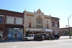 | Booth Theater | under 500 feet | 1988 |
 | Booth Hotel | 0.1 miles | 1983 |
 | Blakeslee Motor Company Building | 0.1 miles | 1989 |
| National Archives record | The nomination case file for reference 06000115 in Record Group 79. |
| Montgomery County | All 30 listed properties in this county. |