 Block
From the record
One of 30 National Register listings published here for Montgomery County · listed in 2008 · category: Building.
Sources: the National Register database, National Park Service
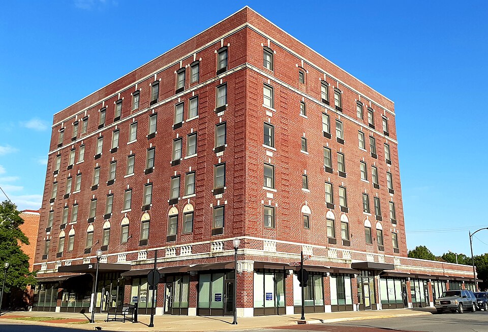
Listed on the National Register of Historic Places in 2008.
One of 30 National Register listings published here for Montgomery County · listed in 2008 · category: Building.
Sources: the National Register database, National Park Service
Regional context, not property-specific evidence. The federal wildfire occurrence database lists 60 fires within 5 miles of Hotel Dale between 2015 and 2020, burning about 92 acres in total. 2 started naturally. 6 were recorded as arson. Distance is straight-line from the map coordinates, so a fire counted here may appear on a neighbouring settlement's page as well.
| Reported cause | Fires |
|---|---|
| Missing data/not specified/undetermined | 24 |
| Debris and open burning | 17 |
| Arson/incendiarism | 6 |
| Other causes | 4 |
| Smoking | 3 |
| Equipment and vehicle use | 3 |
| Natural | 2 |
| Misuse of fire by a minor | 1 |
The most recent of them, most recent first, with the day each was reported and the service that recorded it.
| Date | Cause | Size | Reported by | Name on the report |
|---|---|---|---|---|
| 25 September 2015 | Smoking | under an acre | Kansas Forest Service | 766 |
| 4 August 2020 | Debris and open burning | 2.0 acres | Kansas Forest Service | not named |
| 22 August 2018 | Debris and open burning | under an acre | Kansas Forest Service | 695 |
| 19 August 2018 | Missing data/not specified/undetermined | 2.0 acres | Kansas Forest Service | 1820166 |
| 8 July 2020 | Missing data/not specified/undetermined | 5.0 acres | Kansas Forest Service | not named |
| 8 July 2018 | Debris and open burning | under an acre | Kansas Forest Service | 1820148 |
| 4 July 2018 | Debris and open burning | under an acre | Kansas Forest Service | 546 |
| 11 June 2020 | Missing data/not specified/undetermined | 2.0 acres | Kansas Forest Service | not named |
Regional context, not property-specific evidence. The federal mineral resources record lists 3 workings within 5 miles of Hotel Dale: 2 past producers, 1 producer. 1 still produces. What was taken out: Sand and Gravel, Construction, Stone, Crushed/Broken. Distance is straight-line from the map coordinates, so a quarry counted here may appear on a neighbouring settlement's page as well.
| Where | Site | Commodity | Status | Recorded |
|---|---|---|---|---|
| Coffeyville Quarry & Mill #17 | Stone, Crushed/Broken | Producer | ||
| Unknown Gravel Pit | Sand and Gravel, Construction | Past Producer | ||
| Unknown Gravel Pit | Sand and Gravel, Construction | Past Producer |
Regional context, not property-specific evidence. The National Weather Service names Coffeyville, the town this property stands in, in 124 storm reports between 1993 and 2026: 61 hail, 45 thunderstorm wind, 8 flood, 3 flash flood. The reports record 1 death. Each account below is quoted exactly as the forecast office filed it, from the NOAA Storm Events Database, and each date opens the federal record of that event.
| When | Event | Place named | Harm | What the report says |
|---|---|---|---|---|
| July 2007 | Flash Flood | Coffeyville | 1 killed, $81,150,000 | Extremely heavy rainfall from the end of June into early July caused flash flooding throughout Montgomery County. The hardest hit areas were Independence and Coffeyville. The flash flooding combined with the ensuing record river flooding along the Verdigris River led to at least 500 homes being destroyed with another 55 sustaining major damages. Businesses in the county reported 23 million in losses and the cost to public infrastructure resulted in another 4 million in damages. Additionally, 43,000 acres of cropland were flooded. The Verdigris River also overtopped a levee protecting the refinery in Coffeyville resulting in an oily toxic mess that inundated areas downstream. The Verdigris River at Independence crested at 52.4 feet in the morning hours of July 1st. This was 22.4 feet above flood stage. At Coffeyville the river crested at 30.7 feet the evening of July 1st which is 12.7 above flood stage. Again, both of these crests were records. The river remained above flood stage for both cities until July 7th. Unfortunately there was one fatality. A 55 year old man was found in the Budget Inn in Coffeyville. An autopsy revealed that the individual died as a result of drowning. This tragedy was compounded by the fact that the individual was warned twice that floodwaters would inundate the hotel but on both occasions the individual refused to leave. The Coffeyville Journal and the Arkansas City Traveler contributed to this report. |
| April 2016 | Thunderstorm Wind | Coffeyville | $500,000 | This was a delayed report of significant property damage to the residential and business district areas of Coffeyville. Numerous large trees were uprooted/damaged. Power lines and power poles were blown down and at the time of the report remained down. Some areas of Coffeyville were still without power. Details regarding damage are unknown, so the monetary losses are a rough estimate. |
| April 1999 | Thunderstorm Wind | Coffeyville | $500,000 | Two aircraft were blown over near Cessna plant. |
| March 2002 | Thunderstorm Wind | Coffeyville | $75,000 | Large section of roof torn from a church and blown onto adjacent building. |
| March 2011 | Hail | Coffeyville | $50,000 | Golfball to ping-pong ball size hail pelted Coffeyville during the early morning hours of the 19th. The hail dented numerous vehicles across town, damaged air conditioning units at the Public Library and City Hall, and also damaged about 40 globes on downtown street lights. Property damage amounts are rough estimates. The Montgomery County Chronicle and Independence Daily Reporter contributed to this report. |
| July 2005 | Thunderstorm Wind | Coffeyville | $35,000 | Tree possessing 2.5 foot diameter trunk uprooted and fell onto house. House destroyed. |
| July 2010 | Thunderstorm Wind | Coffeyville | $30,000 | Wind damage to power poles from 2 miles south of Coffeyville to two miles east of Coffeyville. |
| July 2002 | Lightning | Coffeyville | $30,000 | Initially striking the roof of a house, the lightning travelled down electrical wiring inside a bedroom wall, came out a power receptacle just above the bed, and ignited bedding and the mattress against the wall. The strike also caused other unspecified structural and electrical damage to the same house. |
| May 2020 | Thunderstorm Wind | Coffeyville | $20,000 | A few trees were blown down and a power pole was down in town. |
| September 2020 | Flood | Coffeyville | $15,000 | Street flooding occurred in Coffeyville, Kansas where rainfall amounts of 2 to 4 inches were reports. At least one vehicle stalled in the water from the flooding. The 24-hour rainfall report i2 miles east of Coffeyville was 3.41 inches and the amount recorded at the airport was 2.52 inches. |
| May 2005 | Thunderstorm Wind | Coffeyville | $15,000 | Tree damage, including numerous limbs that fell onto houses, vehicles and power lines. The 3rd instance no doubt resulted in power outages, most of which occurred on the west side of town. Time of the event is an approximation based on earlier severe convection. (Report and narrative courtesy of Coffeyville Journal.) |
| September 2022 | Thunderstorm Wind | Coffeyville | $10,000 | Numerous tree limbs were knocked down. Pea size hail was also reported. |
| June 1996 | Thunderstorm Wind | Coffeyville | $10,000 | no account filed |
| June 1996 | Thunderstorm Wind | Coffeyville | $5,000 | no account filed |
| May 1993 | Hail | Coffeyville | $5,000 | no account filed |
| May 1993 | Thunderstorm Wind | Coffeyville | $5,000 | no account filed |
| September 2022 | Thunderstorm Wind | Coffeyville | $2,500 | A tree was reported blown down by the damaging winds. |
| August 2010 | Thunderstorm Wind | Coffeyville | $2,000 | Strong thunderstorm winds tore off an auto dealer's tin roof during the evening hours on the 31st. |
| April 2003 | Lightning | Coffeyville | $1,000 | Church steeple struck. Damage confined to top 4 feet of steeple. |
| April 1994 | Thunderstorm Wind | Coffeyville | $500 | no account filed |
| April 2026 | Hail | Coffeyville | - | Mostly dime size hail with a few quarters. |
| April 2026 | Hail | Coffeyville | - | Delayed report with the time estimated via radar. |
| May 2025 | Thunderstorm Wind | Coffeyville | - | Large tree limbs were down near downtown Coffeyville according to KGGF Radio. |
| May 2025 | Thunderstorm Wind | Coffeyville | - | Wind gusts were estimated to be between 65 and 70 mph. Additionally, three-inch diameter tree limbs were knocked down. |
| February 2024 | Heavy Rain | Coffeyville | - | This is a 24 hour rainfall total of 1.40 inches. |
| May 2024 | Hail | Coffeyville | - | An mPing report was sent in of golf ball sized hail. |
| April 2024 | Thunderstorm Wind | Coffeyville | - | Three inch tree limbs were reported down in town. |
| June 2024 | Thunderstorm Wind | Coffeyville | - | A trained spotter estimated 60 mph winds. |
| June 2024 | Flood | Coffeyville | - | Law enforcement reports street flooding in Coffeyville. U.S. Highway 169 was closed to the state line due to flooding. |
| August 2024 | Thunderstorm Wind | Coffeyville | - | A six by eight-foot shed was rolled, and a metal roof was peeled off of another shed. Also, numerous large tree branches were down. Report was relayed via social media. |
| August 2020 | Thunderstorm Wind | Coffeyville | - | The emergency manager reported the gust. |
| April 2019 | Thunderstorm Wind | Coffeyville | - | This is a measured wind gust. |
| May 2019 | Flood | Coffeyville | - | Sunflower Rd. was reported closed just north of Coffeyville. |
| July 2019 | Thunderstorm Wind | Coffeyville | - | No damage was reported. |
| August 2019 | Thunderstorm Wind | Coffeyville | - | The report was received via Social Media. |
| July 2018 | Thunderstorm Wind | Coffeyville | - | A delayed report was received of 2 power poles that were blown down in and around Coffeyville. The 1st was in town while the 2nd was just south of town. The time of the event is estimated based on radar. |
| June 2018 | Thunderstorm Wind | Coffeyville | - | Measured by official observing equipment. |
| March 2016 | Flood | Coffeyville | - | Minor street flooding was reported in town and in low-water crossings. |
| March 2016 | Hail | Coffeyville | - | The time of the report was estimated per radar. |
| April 2015 | Hail | Coffeyville | - | Relayed by FOX23 out of Tulsa. |
| May 2015 | Flood | Coffeyville | - | In Coffeyville, 11th and Walnut which is at the intersection of highways 166 and 169 was flooded and not passable. Several other county roads had minor flooding with some water being noted over the roads. Two to four inches of rain fell across the county. |
| November 2015 | Hail | Coffeyville | - | The hail was reported in town. |
| October 2014 | Heavy Rain | Coffeyville | - | The Coffeyville water plant measured 6.45 inches of rain over the previous 12 hours. |
| July 2014 | Thunderstorm Wind | Coffeyville | - | No details were provided. |
| July 2014 | Thunderstorm Wind | Coffeyville | - | A second gust estimated at 60 mph occurred at the same location as the 60 mph that occurred at 1104 AM CST. |
| May 2013 | Thunderstorm Wind | Coffeyville | - | Wind apparently pushed a vehicle off of the road. |
| May 2013 | Thunderstorm Wind | Coffeyville | - | Trees were blown down and several windows were blown out due to wind driven hail. |
| August 2011 | Thunderstorm Wind | Coffeyville | - | Some trees were blown down just outside of Coffeyville. |
| September 2010 | Thunderstorm Wind | Coffeyville | - | Quarter size hail was also reported with the strong wind gusts. |
| August 2009 | Hail | Coffeyville | - | Winds of 40 to 50 mph occurred with the hail. |
| May 2008 | Flood | Coffeyville | - | Minor street flooding was reported in the town of Coffeyville. |
| May 2008 | Flood | Coffeyville | - | Numerous thunderstorms training across the area produced street flooding in Coffeyville, and Highway 166 from eastern Chautauqua county into southern Montgomery county experienced spotty flooding. |
| May 2008 | Flood | West Coffeyville | - | The two creeks that converge near Buckeye Creek are out of their banks. Several streets in Coffeyville are also covered in water. |
| August 2005 | Thunderstorm Wind | Coffeyville | - | Downed limbs. |
| August 2005 | Thunderstorm Wind | Coffeyville | - | Downed limbs. (CO-OP Observer.) |
| April 2003 | Tornado (F0) | Coffeyville | - | Spotted by NWS Tulsa spotters. The tornado moved just north of the KS/OK border in open country. |
| April 2003 | Tornado (F0) | Coffeyville | - | Brief event in the country. |
| April 2003 | Hail | Coffeyville | - | Relayed by WFO SGF. |
| May 2003 | Tornado (F0) | Coffeyville | - | Brief event in the country. |
| March 2002 | Thunderstorm Wind | Coffeyville | - | Coffeyville ASOS. |
No historic map-sheet match is published for this property yet. That does not mean no map exists. This record needs a coordinate-quality review before it can be joined to a sheet boundary. Browse the county's mapped places while that work is pending.
Other National Register properties close enough to walk or drive between, ordered by distance from this one. Both positions come from the same geocoding pass that matched these properties to their map sheets.
| Photograph | Property | Distance | Listed |
|---|---|---|---|
 | Condon National Bank | 0.1 miles | 1973 |
| Terminal Building | 0.1 miles | 1982 | |
| Midland Theater | 0.2 miles | 2005 | |
 | Bethel African Methodist Episcopal Church | 0.3 miles | 1995 |
 | Coffeyville Carnegie Public Library Building | 0.3 miles | 1987 |
 | W. P. Brown Mansion | 1.1 miles | 1976 |
| National Archives record | The nomination case file for reference 07001483 in Record Group 79. |
| Montgomery County | All 30 listed properties in this county. |