
BlockBefore
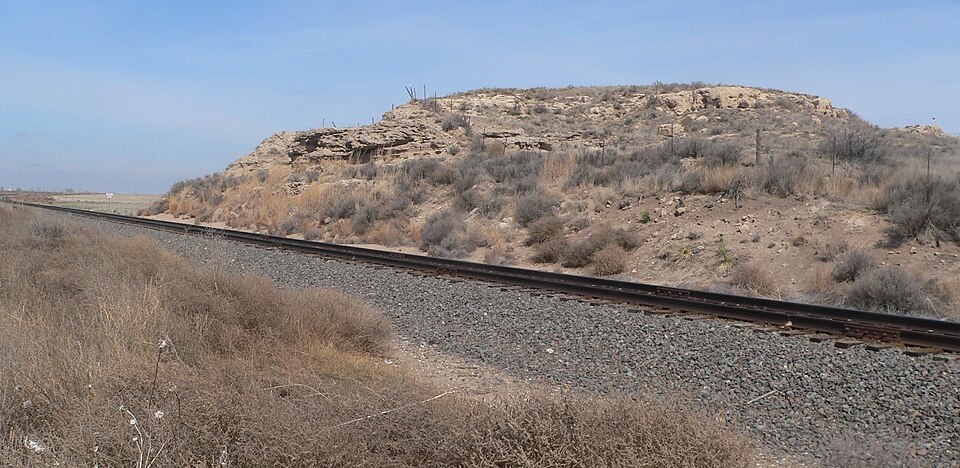
Photograph of Finney County Point of Rocks
Photograph by Ammodramus, CC0 1.0. Via Wikimedia Commons.

Finney County Point of Rocks

Listed on the National Register of Historic Places in 2013.

From the record

“Finney County Point of Rocks, near Mansfield, Kansas, was listed on the National Register of Historic Places in 2013. It was a landmark on the Santa Fe Trail, in the section between the Lower and Upper Arkansas River crossings, before travelers had to choose between the Mountain Route or the Cimmaron Route of the trail.”

Wikipedia article Finney County Point of Rocks, CC BY-SA 4.0.

One of 13 National Register listings published here for Finney County · listed in 2013 · category: Site.

Sources: the Wikipedia article · the National Register database, National Park Service

The listing

  • Address. Mansfield Rd., Pierceville, 67878
  • When was it listed? July 2013
  • Category. site
  • Also known as. Santa Fe Trail MPS
  • National Register reference number. 13000487 - assigned by the National Park Service when the property was listed.

Storms near this property

36 since 1993

Regional context, not property-specific evidence. The National Weather Service names Pierceville, the town this property stands in, in 36 storm reports between 1993 and 2024: 18 thunderstorm wind, 17 hail, 1 tornado. No death or injury is recorded in these reports. Each account below is quoted exactly as the forecast office filed it, from the NOAA Storm Events Database, and each date opens the federal record of that event.

WhenEvent Place namedHarm What the report says
August 1999Thunderstorm WindPierceville$65,000Pivot sprinkler was destroyed...many trees were blown down and 11 power poles were blown down.
May 1995Thunderstorm WindPierceville$20,000Two mobile homes blown over and windows blown out others.
August 1999Thunderstorm WindPierceville$9,000A fully loaded semi truck trailer w/o wheels, used as a storage shed, was moved 10 feet. Shingles and the felt pad were completely stripped off a house. Ten additional power poles were blown down.
September 1993HailPierceville$5,000no account filed
June 1997Thunderstorm WindPierceville$500Window blown out of a house.
February 2024Tornado (EFU)Pierceville-Photos were sent into the NWS on social media of the landspout tornado.
July 2020Thunderstorm WindPierceville-A large cottonwood tree was blown down by the high wind.
May 2018Thunderstorm WindPierceville-A semi truck was blown over by the high wind.
October 2017HailPierceville-The hail stones were jagged.
July 2015Thunderstorm WindPierceville-Winds were estimated to be 60 MPH.
May 2011HailPierceville-Baseball to softball sized hail was observed.
May 2011HailPierceville-Hail was from tennis to baseball sized.
May 2006Thunderstorm WindPierceville-estimated wind of 50 to 70 mph.
May 2001Thunderstorm WindPierceville-Measured by Doppler on Wheels.
May 1999HailPierceville-Wheat was shredded.
May 1999Thunderstorm WindPierceville-Shingles blown off and had 4 inch diameter tree limbs down.
May 2011HailPierceville-no account filed
April 2006HailPierceville-no account filed
August 2006HailPierceville-no account filed
July 2005HailPierceville-no account filed
July 2004Thunderstorm WindPierceville-no account filed
May 2001HailPierceville-no account filed
July 1999Thunderstorm WindPierceville-no account filed
August 1999HailPierceville-no account filed
June 1999Thunderstorm WindPierceville-no account filed
July 1999Thunderstorm WindPierceville-no account filed
September 1998HailPierceville-no account filed
May 1998HailPierceville-no account filed
June 1997Thunderstorm WindPierceville-no account filed
May 1997Thunderstorm WindPierceville-no account filed
June 1996Thunderstorm WindPierceville-no account filed
May 1995HailPierceville-no account filed
May 1993HailPierceville-no account filed

Every storm recorded in Finney County

Map coverage status

No historic map-sheet match is published for this property yet. That does not mean no map exists. This record needs a coordinate-quality review before it can be joined to a sheet boundary. Browse the county's mapped places while that work is pending.

Sources for this property

National Archives recordThe nomination case file for reference 13000487 in Record Group 79.
Wikipedia articleCommunity-written account of this property, licensed CC BY-SA.
Finney CountyAll 13 listed properties in this county.

Provenance

  • Listing record. National Park Service National Register of Historic Places, listed-properties dataset, current to 2026-05-22.
  • Map join. Address geocoded through the United States Census geocoder, then tested against the published boundary of every sheet in the USGS Historical Topographic Map Collection.
  • How this page is made. Listing fields come from federal records; map-sheet coverage is a labelled coordinate-to-boundary calculation, not a source-field claim.
  • Storms. NOAA National Centers for Environmental Information, Storm Events Database https://www.ncei.noaa.gov/stormevents/ A work of the United States government, no copyright under 17 U.S.C. 105. Narratives are quoted verbatim from the National Weather Service report and are not edited or summarised.