 Block
From the record
1 National Register listing published here.
Sources: the National Register database, National Park Service
28 topographic sheets cover 23 settlements here, and 1 property is on the National Register of Historic Places.
1 National Register listing published here.
Sources: the National Register database, National Park Service
Every property in this county listed on the National Register of Historic Places, with the year it was listed and the federal nomination document.
| Photograph | Property | Type | Listed | Reference |
|---|---|---|---|---|
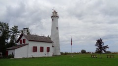 | Sturgeon Point Light Station | building | 1984 | 84001370 |
Every wildfire the federal occurrence database records inside this county: 437 of them, burning about 1,898 acres. 15 started naturally and 23 were recorded as arson. Each settlement page carries the fires within five miles of it.
| Reported cause | Fires |
|---|---|
| Debris and open burning | 141 |
| Missing data/not specified/undetermined | 89 |
| Equipment and vehicle use | 57 |
| Recreation and ceremony | 43 |
| Power generation/transmission/distribution | 34 |
| Arson/incendiarism | 23 |
| Natural | 15 |
| Smoking | 14 |
| Misuse of fire by a minor | 8 |
| Other causes | 6 |
| Fireworks | 6 |
| Railroad operations and maintenance | 1 |
The five largest, by the area the report gives. Three of them were set deliberately.
| Date | Cause | Size | Reported by | Name on the report |
|---|---|---|---|---|
| 3 May 2015 | Arson/incendiarism | 472 acres | Huron-Manistee National Forest | UNHAPPY CAMPER |
| 30 April 1999 | Recreation and ceremony | 239 acres | Huron-Manistee National Forest | UNHAPPY CAMPER |
| 4 June 2003 | Arson/incendiarism | 98 acres | Huron-Manistee National Forest | ASPEN ALLEY #1 |
| 25 March 1995 | Equipment and vehicle use | 85 acres | Michigan Department of Natural Resources | not named |
| 2 May 2013 | Debris and open burning | 54 acres | Huron-Manistee National Forest | QUICK ROAD |
| 28 April 2003 | Arson/incendiarism | 51 acres | Huron-Manistee National Forest | MCKINLEY |
| 20 March 2012 | Missing data/not specified/undetermined | 40 acres | Michigan Department of Natural Resources | ALCONA 02 - WALKER |
| 17 April 1994 | Equipment and vehicle use | 30 acres | Michigan Department of Natural Resources | not named |
Every settlement page carries the fires within five miles of it - see the settlement index below.
The NOAA Storm Events Database holds 137 reports for this county, causing no deaths, 1 injury and about $5,916,780 in recorded property damage. Each settlement page carries the reports that name it.
| Kind of event | Reports |
|---|---|
| Thunderstorm Wind | 63 |
| Hail | 57 |
| Tornado | 12 |
| Flash Flood | 3 |
| Flood | 2 |
The most serious of them, by death, then injury, then recorded damage. The accounts are quoted exactly as the forecast office filed them.
| When | Event | Place named | Harm | What the report says |
|---|---|---|---|---|
| July 2001 | Thunderstorm Wind | Curtisville | 1 hurt, $2,000 | Thunderstorm downed several trees. One truck had its windshield broken by flying debris and a female passenger in the truck was injured. |
| March 1991 | Tornado (F3) | not stated | $2,500,000 | no account filed |
| March 1991 | Tornado (F3) | not stated | $2,500,000 | no account filed |
| July 1999 | Tornado (F1) | Barton City | $250,000 | Continuation of Oscoda County tornado. Hundreds of trees down and 16 homes damaged. |
| June 1953 | Tornado (F3) | not stated | $250,000 | no account filed |
| June 2008 | Flash Flood | Harrisville Arpt | $100,000 | Several rounds of slow-moving thunderstorms dumped heavy rain across far southern Alcona County. Radar estimated three to six inches of rainfall in Mikado and Greenbush Townships. Flash flooding occurred on Grey and Roy Creeks, washing out several driveways and side roads, and closing parts of Alvin, Goddard, and London Roads. |
| June 2008 | Tornado (EF1) | Backus Beach | $50,000 | EF1 tornado, with winds estimated up to 100 mph. Tornado tracked through a heavily forested area, downing many trees west of Mount Maria Road, east of Consolidated Road, and north of the West Branch River. |
| July 2017 | Flash Flood | Lincoln | $40,000 | Two separate rain gauges in the Lincoln area measured around seven inches of rain in a three-hour period. Numerous roads in the Lincoln area were inundated and closed for part of the evening, including Gehres and Barlow Roads. A number of basements were flooded. |
| August 2025 | Thunderstorm Wind | Backus Beach | $25,000 | Delayed report including images of over two dozen trees uprooted on the east side of Hubbard Lake. Some had fallen on homes. |
| June 1992 | Tornado (F1) | not stated | $25,000 | no account filed |
| August 1954 | Tornado (F1) | not stated | $25,000 | no account filed |
| July 2013 | Thunderstorm Wind | Barton City | $24,000 | Several trees were downed onto homes, and power outages were widespread. |
| July 2016 | Thunderstorm Wind | Mc Ginn | $15,000 | A camper was blown open, and an outbuilding had its roof torn off. |
| October 2007 | Tornado (EF1) | Mc Ginn | $15,000 | This is the 2nd segment of a tornado that originated near McCollum Lake in Oscoda County. The damage path was sporadic in Alcona County, as the parent storm raced to the northeast. Damage was confined to trees in Alcona County. Winds were estimated at 105 mph, making it an EF1. |
| July 2008 | Flash Flood | Backus Beach | $10,000 | Radar estimated three to five inches of rain fell during the late afternoon hours in the northern third of Alcona County. Mount Maria Road was flooded near the south end of Hubbard Lake. Hubbard Lake Road also went underwater, between Lake Street and Pine Grove Shores, as well as near Swede Road. |
| May 2007 | Thunderstorm Wind | Curtisville | $10,000 | Large tree downed at a campground, falling onto a camper trailer. Power lost in part of campground. |
| July 2021 | Thunderstorm Wind | Black River | $7,500 | At least five 12-18 inch size trees down on the property due to strong winds. Minor damage was done to one building as one tree fell against it. |
| June 2014 | Thunderstorm Wind | Mikado | $7,000 | Two blue spruce trees were downed, and shingles were torn off of a roof. |
| May 2013 | Thunderstorm Wind | Glennie | $7,000 | Numerous trees and power lines were downed. |
| May 2013 | Thunderstorm Wind | Greenbush | $6,000 | Multiple trees were downed on South Poor Farm Road. |
| November 2013 | Thunderstorm Wind | Barton City | $6,000 | Scattered trees were downed in central Alcona County. |
| August 2016 | Thunderstorm Wind | Harrisville Arpt | $5,000 | Multiple trees were knocked down, resulting in a localized power outage. |
| July 2013 | Thunderstorm Wind | Harrisville Arpt | $5,000 | Scattered trees were downed in eastern Alcona County. |
| July 2006 | Thunderstorm Wind | Curran | $5,000 | Trees and power lines downed at intersection of M-65 and Hubbard Lake Trail. |
| July 2014 | Thunderstorm Wind | Glennie | $4,000 | Numerous trees were downed. |
| October 2007 | Thunderstorm Wind | Mc Ginn | $4,000 | Several trees were downed by thunderstorm winds. |
| July 2006 | Thunderstorm Wind | Curran | $3,000 | Trees and power lines downed. |
| July 1967 | Tornado (F1) | not stated | $2,500 | no account filed |
| July 1956 | Tornado (F1) | not stated | $2,500 | no account filed |
| June 2007 | Thunderstorm Wind | Barton City | $2,000 | Trees and power lines were downed near the intersection of O'Donnell Road and M-72. |
| August 2006 | Thunderstorm Wind | Glennie | $2,000 | Tree downed onto power lines. |
| June 2005 | Thunderstorm Wind | Spruce | $2,000 | Trees were downed near Spruce Road and F-41. |
| June 2005 | Thunderstorm Wind | Harrisville | $2,000 | Trees were knocked down at Everett and Trask Lake Roads. |
| June 2005 | Thunderstorm Wind | Harrisville | $2,000 | A large tree and some power lines were downed by wind. |
| June 2007 | Thunderstorm Wind | Mikado | $1,000 | Power lines were downed in Mikado. |
| July 1953 | Tornado (F0) | not stated | $250 | no account filed |
| March 1976 | Tornado (F2) | not stated | $30 | no account filed |
| August 2025 | Hail | Spruce | - | Multiple reports of hailstones up to the size of ping pong balls around the Hubbard Lake area in northern Alcona county. |
| August 2025 | Hail | Lost Lake Woods | - | Reports of quarter size hail in the Long Lake Woods area in central Alcona county. |
| May 2025 | Hail | Greenbush | - | A short burst of hail for about 5 minutes, resulting in hail up to the size of nickels near Greenbush in Alcona county. Most hail stones were one-half inch diameter or smaller. |
| July 2018 | Hail | Mikado | - | Quarter sized hail damaged gardens in the area. |
| April 2011 | Hail | Lost Lake Woods | - | Hail covered the ground. |
| June 2008 | Hail | Backus Beach | - | Quarter sized hail covered the ground up to six inches deep. |
| June 2008 | Flood | Mikado | - | High water from earlier flash flooding lingered on a number of roads, especially along Roy and Grey Creeks. |
| July 2008 | Flood | Spruce | - | Flooding lingered in the Hubbard Lake area through the night. A few additional thunderstorms moved through the region, with radar estimates topping out at four to eight inches of rain during the afternoon and night of the 17th. |
| July 2004 | Thunderstorm Wind | Lincoln | - | Wind gust estimated by a spotter. |
| July 2004 | Thunderstorm Wind | Glennie | - | Trees were downed. |
| August 2004 | Thunderstorm Wind | Mikado | - | Trees were downed. |
| August 2004 | Thunderstorm Wind | Glennie | - | Several trees were downed. |
| July 2003 | Thunderstorm Wind | Harrisville | - | Numerous tree limbs downed. |
| July 2002 | Thunderstorm Wind | Spruce | - | Several trees down. |
| September 2002 | Thunderstorm Wind | Glennie | - | Numerous trees down. |
| September 2002 | Thunderstorm Wind | Harrisville | - | Telephone pole blown over and several large branches down. |
| June 2001 | Thunderstorm Wind | Black River | - | Several trees and power lines down. |
| August 2001 | Thunderstorm Wind | Harrisville | - | Trees down. |
| May 2000 | Thunderstorm Wind | Countywide | - | Trees and power lines were blown down over portions of the entire county. |
| September 1998 | Thunderstorm Wind | Lincoln | - | Numerous trees snapped off and/or uprooted. Many powerlines down. |
| May 1998 | Thunderstorm Wind | Glennie | - | Strong straight-line winds downed numerous trees of up to 8 - 12" in diameter in Glennie Park. One mobile home was destroyed by a falling tree. |
| June 1998 | Thunderstorm Wind | Glennie | - | Strong winds downed trees along routes M-65...M-72 and F-30. |
| July 1997 | Thunderstorm Wind | Mikado | - | Strong thunderstorm winds toppled numerous trees south of Mikado. |
The Survey's mineral resources record lists 6 workings inside this county. 3 still produce and 3 are closed or unrecorded. Each settlement page carries the workings within five miles of it.
| Commodity | Workings |
|---|---|
| Sand and Gravel, Construction | 5 |
| Clay | 1 |
The least common of them first, because a county's hundredth gravel pit says nothing its first ten did not.
| Where | Site | Commodity | Status | Recorded |
|---|---|---|---|---|
| Unnamed Clay Pit | Clay | Past Producer | ||
| Greenbush Pit &Mill | Sand and Gravel, Construction | Past Producer | ||
| Slater No 1 Pit and Mill | Sand and Gravel, Construction | Past Producer | ||
| State Pit # 132 | Sand and Gravel, Construction | Producer | ||
| State Pit # 414 | Sand and Gravel, Construction | Producer | ||
| State Pit #232 | Sand and Gravel, Construction | Producer |
Named settlements recorded in the Geographic Names Information System, each with the topographic sheets covering it. Villages, hamlets and abandoned places alike. Each is shown with the nearest named watercourse or landform and the survey quadrangle it falls on.
Hawes township · 48762 · Near Mount Maria · Hubbard Lake quadrangle
9 sheets, 1954 to 1983
Alcona township · 48721 · On Black River · Black River quadrangle
8 sheets, 1954 to 1983
Harrisville city · 48740 · On Mill Creek · Harrisville quadrangle
11 sheets, 1954 to 1989
Hawes township · 48762 · Near Mount Maria · Hubbard Lake quadrangle
9 sheets, 1954 to 1983
Mikado township · 48745 · On West Branch Pine River · Mikado quadrangle
11 sheets, 1954 to 1989