 Block
From the record
6 National Register listings published here.
Sources: the National Register database, National Park Service
48 topographic sheets cover 21 settlements here, and 6 properties are on the National Register of Historic Places.
6 National Register listings published here.
Sources: the National Register database, National Park Service
Every property in this county listed on the National Register of Historic Places, with the year it was listed and the federal nomination document.
| Photograph | Property | Type | Listed | Reference |
|---|---|---|---|---|
 | Antrim County Courthouse | building | 1980 | 80001846 |
 | Elk Rapids First Methodist Episcopal Church | building | 2015 | 15000945 |
 | Elk Rapids Township Hall | building | 1977 | 77000709 |
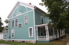 | Hughes House | building | 1976 | 76001024 |
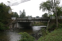 | M-88-Intermediate River Bridge | structure | 1999 | 99001574 |
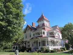 | Henry Richardi House | building | 1978 | 78001491 |
Every wildfire the federal occurrence database records inside this county: 217 of them, burning about 356 acres. 8 started naturally and 5 were recorded as arson. Each settlement page carries the fires within five miles of it.
| Reported cause | Fires |
|---|---|
| Debris and open burning | 79 |
| Equipment and vehicle use | 45 |
| Missing data/not specified/undetermined | 33 |
| Recreation and ceremony | 22 |
| Misuse of fire by a minor | 12 |
| Smoking | 9 |
| Natural | 8 |
| Arson/incendiarism | 5 |
| Power generation/transmission/distribution | 1 |
| Railroad operations and maintenance | 1 |
| Fireworks | 1 |
| Other causes | 1 |
The five largest, by the area the report gives. None of them was recorded as arson.
| Date | Cause | Size | Reported by | Name on the report |
|---|---|---|---|---|
| 3 April 2004 | Debris and open burning | 35 acres | Michigan Department of Natural Resources | not named |
| 11 April 2005 | Debris and open burning | 22 acres | Michigan Department of Natural Resources | ANTRIM #006 |
| 14 April 2003 | Recreation and ceremony | 19 acres | Michigan Department of Natural Resources | not named |
| 24 May 2012 | Recreation and ceremony | 15 acres | Michigan Department of Natural Resources | ANTRIM 03 |
| 11 November 2016 | Smoking | 12 acres | Michigan Department of Natural Resources | not named |
| 12 April 1993 | Debris and open burning | 12 acres | Michigan Department of Natural Resources | not named |
| 16 April 2008 | Missing data/not specified/undetermined | 9.3 acres | Michigan Department of Natural Resources | ANTRIM 01 |
| 22 August 1992 | Equipment and vehicle use | 8.5 acres | Michigan Department of Natural Resources | not named |
Every settlement page carries the fires within five miles of it - see the settlement index below.
The NOAA Storm Events Database holds 129 reports for this county, causing no deaths, 4 injuries and about $2,045,780 in recorded property damage. Each settlement page carries the reports that name it.
| Kind of event | Reports |
|---|---|
| Thunderstorm Wind | 72 |
| Hail | 37 |
| Tornado | 13 |
| Flash Flood | 3 |
| Lightning | 3 |
| Flood | 1 |
The most serious of them, by death, then injury, then recorded damage. The accounts are quoted exactly as the forecast office filed them.
| When | Event | Place named | Harm | What the report says |
|---|---|---|---|---|
| July 1974 | Tornado (F3) | not stated | 2 hurt, $250,000 | no account filed |
| August 2021 | Flash Flood | Alden | 1 hurt, $325,000 | Alden highway completely washed out near Comfort Rd. Two vehicles fell into road wash out causing injury to 1 person. Multiple other road sections washed throughout county. |
| June 2005 | Thunderstorm Wind | Alba | 1 hurt | A female hiker was struck by a falling tree in the Landslide Creek area. Her injuries were not serious. |
| August 2015 | Thunderstorm Wind | Kewadin | $600,000 | Considerable wind damage occurred in southwest and south central Antrim County. Many hundreds of trees were downed in these areas, with some resulting in damage to vehicles and structures. Some side streets were difficult to access for a day or two after the storm. Between 40 and 50 structures suffered some amount of damage from the storm. |
| May 2022 | Tornado (EF1) | Alba | $175,000 | The tornado formed 4 miles east of Alba in a location on Olds Rd 0.5 miles east of the Alba Rd intersection. It tracked east northeast for about 1.75 miles before exiting Antrim county 200 yards southeast of the Alba Rd/Old Alba Rd intersection. The tornado continued in Otsego county for almost 16 additional miles before dissipating at 1457 EST. In Antrim county, no injuries or fatalities were reported. Several homes were damaged along with numerous softwood trees snapped at their trunks (DI 28, DOD 4) along Patterson Rd. While the highest rating of EF1 in Antrim county was assigned at this location, the tornado was rated EF3 in Otsego county. The maximum path width in Antrim county was 200 yards. |
| August 2018 | Tornado (EF0) | Alba | $80,000 | A tornado with estimated maximum winds of 80 mph touched down south of Alba, and followed a discontinuous path to the northeast, lifting just before the Otsego County line. A number of hardwood and softwood trees were downed. |
| June 2012 | Lightning | Ellsworth | $80,000 | Lightning struck a home in Banks Township, igniting a fire that destroyed the home. |
| July 2024 | Lightning | Chestonia | $65,000 | A cooperative observer reported lightning struck a trailer house, setting it ablaze, in the vicinity of East Jordan on the morning of July 14th. This report was corroborated by the Charlevoix Emergency Manager as well as Facebook reports. The structure was two trailer houses joined together; it was a total loss due to the fire. The occupants were all hospitalized...2 were taken to a nearby hospital in Petoskey where they were listed in fair condition; the third had to be transported to a larger hospital in Grand Rapids to receive treatment for his injuries for multiple days. |
| July 2016 | Hail | Central Lake | $65,000 | Numerous vehicles were dented by very large hail, and some windows were broken. Area fruit crops sustained considerable damage. |
| August 2017 | Tornado (EF0) | Kewadin | $55,000 | An EF0 tornado crossed Williams Drive at the south end of Birch Lake, then dissipated over the lake. Maximum wind speed was estimated at 80 mph. Many trees were uprooted in the area, and a few homes were damaged by falling trees. Saturated soils likely contributed to the number of uprooted trees. |
| June 2005 | Thunderstorm Wind | Mancelona | $40,000 | Numerous trees were downed. A garage was destroyed by a falling tree. A large billboard was bent over. |
| May 2022 | Hail | Alba | $30,000 | Report of hail smaller than baseballs resulting in roof, siding, and garage door damage to two houses. |
| August 2018 | Thunderstorm Wind | Alden | $28,000 | Pockets of trees and power lines downed in many parts of Antrim County, but especially in the south half of the county. |
| May 2022 | Thunderstorm Wind | Chestonia | $25,000 | Report estimating an 80 foot wide swath of trees down on the southwest side of Walloon Lake. |
| July 2006 | Thunderstorm Wind | Bellaire | $25,000 | Numerous trees downed. Roof and large deck of home near Shanty Creek heavily damaged by fallen trees. |
| September 2013 | Thunderstorm Wind | Alden | $21,000 | Several large trees were downed, one of which crushed a vehicle. Crystal Springs Road was blocked by downed trees. |
| May 2022 | Thunderstorm Wind | Bellaire Antrim Arpt | $20,000 | Reports of trees and wires down in Bellaire. Time estimated from radar. |
| September 2018 | Thunderstorm Wind | Central Lake | $18,000 | Scattered trees were downed in northern and western Antrim County. |
| May 2011 | Thunderstorm Wind | Mancelona | $18,000 | Sporadic tree damage, with a few trees down along with numerous large limbs. Power lines downed. |
| June 2023 | Thunderstorm Wind | Ellsworth | $15,000 | Reports of trees downed, with a report of a tree on a house northeast of Ellsworth. Time estimated via radar. |
| September 2005 | Thunderstorm Wind | Countywide | $15,000 | Sporadic tree and power line damage across Antrim County. |
| May 2011 | Thunderstorm Wind | Alden | $10,000 | Numerous trees were downed. |
| July 1995 | Thunderstorm Wind | Bellaire- | $10,000 | Numerous trees and some power lines were downed by the wind between Bellaire and Alden. |
| May 2013 | Thunderstorm Wind | Kewadin | $8,000 | Multiple trees were downed. |
| August 2006 | Thunderstorm Wind | Bellaire | $6,000 | Trees and power lines downed around and on the north side of Bellaire. |
| August 2004 | Thunderstorm Wind | Alden | $6,000 | Numerous trees and power lines were downed. |
| April 2008 | Thunderstorm Wind | Mancelona | $5,000 | A few trees were downed onto power lines in western Mancelona Township, including near Cedar River Rd and Doerr Rd. |
| September 2016 | Thunderstorm Wind | Chestonia | $4,000 | Power lines were downed. A tractor-trailer was overturned near the intersection of M-66 and Bartholomew Road. |
| September 2014 | Thunderstorm Wind | Mancelona | $4,000 | Several trees were downed in southeastern Mancelona. |
| July 2007 | Tornado (EF0) | Alden | $4,000 | A waterspout, associated with some showers, came onshore as a weak tornado near the south end of Torch Lake. The waterspout tore up some docks, and downed a few tree limbs. It was estimated as a low-end EF0 tornado, with winds of around 65 mph. Note that it is not known where the waterspout initially touched down, as the waterspout was not observed until it was already moving onshore. The tornado dissipated almost immediately upon coming onshore. |
| May 2006 | Thunderstorm Wind | Alba | $4,000 | Six to eight trees downed at the Lakes of the North campground. |
| July 2006 | Thunderstorm Wind | Elk Rapids | $4,000 | Large trees downed along US-31. |
| August 2006 | Thunderstorm Wind | Mancelona | $4,000 | Trees and power lines downed. |
| May 2013 | Thunderstorm Wind | Mancelona | $3,000 | A large tree and multiple tree limbs were downed. |
| July 2007 | Thunderstorm Wind | Mancelona | $3,000 | Trees were downed near Cinder Hill Road. |
| August 2006 | Thunderstorm Wind | Mancelona | $3,000 | Several trees downed. |
| April 2021 | Thunderstorm Wind | Kewadin | $2,500 | Numerous downed trees and power lines. |
| May 2022 | Thunderstorm Wind | Central Lake | $2,000 | Scanner reports crews are on the scene of a tree blocking a roadway near central lake. Time estimated via radar. |
| July 2019 | Thunderstorm Wind | Alden | $2,000 | A few trees were downed. |
| June 2011 | Thunderstorm Wind | Bellaire Antrim Arpt | $2,000 | Two large trees were downed. |
| April 2008 | Thunderstorm Wind | Elk Rapids | $2,000 | A large tree was blown down on South Elk Lake Rd near Clearwater Point Road, blocking the roadway. |
| July 2008 | Thunderstorm Wind | Alba | $1,500 | A large metal flag pole was toppled. |
| April 2008 | Thunderstorm Wind | Bellaire Antrim Arpt | $1,500 | A large tree was blown down. |
| May 2007 | Thunderstorm Wind | Kewadin | $1,500 | Numerous tree limbs were downed. A slide was blown off of a playset in a backyard. |
| July 2024 | Flood | Mancelona | $1,000 | Broadcast media showed photos of minor flooding in the Mancelona area. 2.31 inches of rain was reported at an automated mesonet station in Mancelona as of 820pm, with a storm total of over 3 inches reported by a CoCoRaHS observer the next morning. |
| July 2008 | Thunderstorm Wind | Chestonia | $1,000 | Several large tree limbs downed. |
| May 2011 | Thunderstorm Wind | Kewadin | $500 | Tree limbs downed. |
| July 1977 | Tornado (F2) | not stated | $250 | no account filed |
| July 1958 | Tornado (F1) | not stated | $30 | no account filed |
| March 2026 | Hail | Bellaire Antrim Arpt | - | Penny sized hail reported on M-88 north of Bellaire. |
| September 2025 | Tornado (EF0) | Clam River | - | An extremely photogenic tornadic waterspout developed over central Torch Lake and dissipated shortly after making landfall on the eastern shore of Torch Lake north of the mouth of the Clam River. Only minor tree damage was observed. Event was initially reported to NWS Gaylord by a storm chaser watching a Torch Lake area webcam; chaser reported seeing debris lofted in the air on the webcam footage as the waterspout made landfall. |
| September 2025 | Tornado (EF1) | Bellaire | - | An EF-1 tornado touched down on the southwest side of Bellaire and tracked northeast for nearly a mile before dissipating on the north side of Craven Park, producing spotty tree damage across the town and in the park. |
| July 2024 | Thunderstorm Wind | Mancelona | - | Report of powerlines down in the vicinity of Antrim and Mancelona, accompanied by public reports of dime sized hail and torrential rainfall in this area. |
| May 2022 | Hail | Alba | - | One inch hail 4 miles west of Alba. |
| May 2022 | Hail | Alba | - | Facebook photo of golf ball sized hail at the intersection of M 32 and US 131. Time estimated by radar. |
| June 2021 | Hail | Mancelona Muni Arpt | - | Report from social media of dime size hail near Schuss Mountain Golf Course. |
| August 2021 | Flash Flood | Bellaire | - | Water over M-88 in multiple locations. |
| July 2016 | Hail | Central Lake | - | Considerable damage to area crops, including cherries. |
| June 2008 | Thunderstorm Wind | Mancelona | - | A spotter estimated wind gusts to 60 mph. |
| October 2007 | Thunderstorm Wind | Kewadin | - | A spotter estimated wind gusts of 65 mph in Kewadin. |
The Survey's mineral resources record lists 15 workings inside this county. 8 still produce and 7 are closed or unrecorded. Each settlement page carries the workings within five miles of it.
| Commodity | Workings |
|---|---|
| Sand and Gravel, Construction | 8 |
| Clay | 7 |
The least common of them first, because a county's hundredth gravel pit says nothing its first ten did not.
| Where | Site | Commodity | Status | Recorded |
|---|---|---|---|---|
| Ellsworth Shale Pit | Clay | Producer | ||
| Jh Kocher Shale Pit | Clay | Prospect | ||
| Unnamed Shale Pit | Clay | Past Producer | ||
| Unnamed Shale Pit | Clay | Past Producer | ||
| Unnamed Shale Prospect | Clay | Prospect | ||
| William W Johnston Clay Pit | Clay | Past Producer | ||
| Wilsons Farm Shale Pit | Clay | Past Producer | ||
| Antrim Co Pit Schworm Inc | Sand and Gravel, Construction | Producer | ||
| Antrim Co Pit Wiggins & Son | Sand and Gravel, Construction | Producer | ||
| Antrim Co Pits/Tri-Co Sand & Stone | Sand and Gravel, Construction | Producer | ||
| Drenth Bros Pit & Mill | Sand and Gravel, Construction | Producer | ||
| Kler's Pit | Sand and Gravel, Construction | Producer | ||
| Kler's Pit Manthei Dev Corp | Sand and Gravel, Construction | Producer | ||
| Mancelona Pit | Sand and Gravel, Construction | Past Producer | ||
| Wilkes Pit | Sand and Gravel, Construction | Producer |
Named settlements recorded in the Geographic Names Information System, each with the topographic sheets covering it. Villages, hamlets and abandoned places alike. Each is shown with the nearest named watercourse or landform and the survey quadrangle it falls on.
Forest Home township · 49615 · On Cedar River · Bellaire quadrangle
15 sheets, 1954 to 1989
Central Lake township · 49622 · On Knowles Creek · Central Lake quadrangle
12 sheets, 1954 to 1984
Torch Lake township · 49627 · On Eastport Creek · Central Lake quadrangle
12 sheets, 1954 to 1984
Elk Rapids township · 49629 · On Elk River · Elk Rapids quadrangle
12 sheets, 1954 to 1989
Chestonia township · 49659 · Near Mount Bundy · Mancelona quadrangle
16 sheets, 1954 to 1989
Forest Home township · 49615 · On Grass Creek · Bellaire quadrangle
15 sheets, 1954 to 1989
Echo township · 49727 · On Spence Creek · Scotts Lake quadrangle
12 sheets, 1955 to 1984
Forest Home township · 49615 · On Fisk Creek · Scotts Lake quadrangle
12 sheets, 1955 to 1984
No longer a settlement
The vanished settlements of Antrim County: the places named above that are no longer on the map.