 Block
From the record
17 National Register listings published here.
Sources: the National Register database, National Park Service
43 topographic sheets cover 22 settlements here, and 17 properties are on the National Register of Historic Places.
17 National Register listings published here.
Sources: the National Register database, National Park Service
Every property in this county listed on the National Register of Historic Places, with the year it was listed and the federal nomination document.
| Photograph | Property | Type | Listed | Reference |
|---|---|---|---|---|
 | Beaver Island Light Station | building | 1978 | 78001495 |
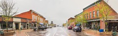 | Boyne City Central Historic District | district | 2012 | 12001071 |
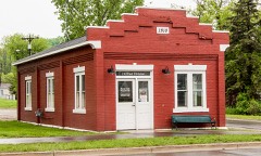 | Boyne City Water Works Building | building | 1998 | 98001060 |
| Charlevoix Central Historic District | district | 2025 | 100011634 | |
 | Charlevoiz South Pierhead Light | structure | 2005 | 05000346 |
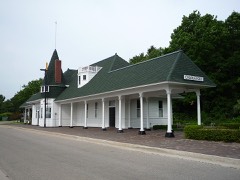 | Chicago and West Michigan Railroad Charlevoix Station | building | 1995 | 95001393 |
 | East Jordan Lumber Company Store Building | building | 2008 | 08000586 |
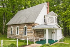 | Greensky Hill Mission | building | 1972 | 72000603 |
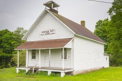 | Horton Bary School | building | 2001 | 00001603 |
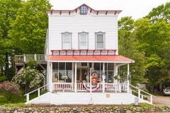 | Horton Bay General Store | building | 1991 | 91001411 |
 | Horton Bay House-Red Fox Inn | building | 1995 | 95000372 |
 | Loeb Farms Barn Complex | building | 1995 | 95001392 |
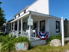 | Mormon Print Shop | building | 1971 | 71000386 |
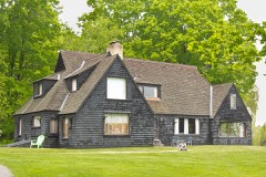 | John J. and Eva Reynier Porter Estate | district | 1998 | 98000269 |
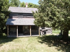 | Feodar Protar Cabin | building | 1972 | 72000604 |
 | Votruba Block | building | 2008 | 08000585 |
 | Wolverine Hotel | building | 1986 | 86000261 |
Every wildfire the federal occurrence database records inside this county: 78 of them, burning about 323 acres. None started naturally and 1 was recorded as arson. Each settlement page carries the fires within five miles of it.
| Reported cause | Fires |
|---|---|
| Debris and open burning | 29 |
| Missing data/not specified/undetermined | 15 |
| Equipment and vehicle use | 12 |
| Recreation and ceremony | 10 |
| Misuse of fire by a minor | 5 |
| Smoking | 3 |
| Power generation/transmission/distribution | 2 |
| Railroad operations and maintenance | 1 |
| Arson/incendiarism | 1 |
The five largest, by the area the report gives. None of them was recorded as arson.
| Date | Cause | Size | Reported by | Name on the report |
|---|---|---|---|---|
| 14 April 2003 | Debris and open burning | 83 acres | Michigan Department of Natural Resources | not named |
| 28 March 1995 | Missing data/not specified/undetermined | 43 acres | Michigan Department of Natural Resources | not named |
| 20 May 1994 | Smoking | 28 acres | Michigan Department of Natural Resources | not named |
| 26 March 2018 | Debris and open burning | 16 acres | Michigan Department of Natural Resources | CHARLEVOIX 01 - MAGEE RD FIRE |
| 4 April 2005 | Debris and open burning | 15 acres | Michigan Department of Natural Resources | not named |
| 18 July 2006 | Debris and open burning | 12 acres | Michigan Department of Natural Resources | not named |
| 29 March 2006 | Debris and open burning | 11 acres | Michigan Department of Natural Resources | not named |
| 5 April 2010 | Debris and open burning | 9.0 acres | Michigan Department of Natural Resources | CHARLEVOIX 01 |
Every settlement page carries the fires within five miles of it - see the settlement index below.
The NOAA Storm Events Database holds 81 reports for this county, causing no deaths, no injuries and about $314,000 in recorded property damage. Each settlement page carries the reports that name it.
| Kind of event | Reports |
|---|---|
| Thunderstorm Wind | 41 |
| Hail | 34 |
| Tornado | 4 |
| Lightning | 1 |
| Flash Flood | 1 |
The most serious of them, by death, then injury, then recorded damage. The accounts are quoted exactly as the forecast office filed them.
| When | Event | Place named | Harm | What the report says |
|---|---|---|---|---|
| May 2013 | Thunderstorm Wind | Horton Bay | $75,000 | A large and historic barn was severely damaged. Multiple trees were downed, one onto a home. |
| July 2016 | Hail | East Jordan | $45,000 | Some vehicles were damaged by very large hail. |
| August 2003 | Thunderstorm Wind | Countywide | $45,000 | A 64 mph gust was measured at the Charlevoix Airport. Numerous trees were downed in Hayes Township and Boyne City. Some the the worst damage was along the south shore of Lake Charlevoix, where docks, boats, and hoists were damaged. A vehicle was damaged when a tree limb fell on it. A seaplane was also blown onto shore and tipped over. Walloon Lake was hard hit as well, with several boats tipped over. |
| March 2025 | Thunderstorm Wind | East Jordan | $40,000 | Large tree blown down onto home, and a roof blown off a campground building, amid other wind damage reports from the East Jordan area. Trained spotter reported a gust to 52 mph in the Boyne City area, and the AWOS sensor at the Boyne Falls airport reported a gust to 51mph at 21:34. Several power outages were noted in the East Jordan area during the evening and overnight, prior to icing-related outages. |
| May 2011 | Thunderstorm Wind | East Jordan | $20,000 | Many trees and power lines were downed. |
| May 2013 | Thunderstorm Wind | Walloon Lake | $15,000 | Trees and power lines downed. Forty trees uprooted at Walloon Lake Country Club. |
| September 2005 | Thunderstorm Wind | Countywide | $15,000 | Numerous trees and power lines down across mainland Charlevoix County. |
| April 2002 | Thunderstorm Wind | East Jordan | $15,000 | Barn roof blown off. |
| September 2016 | Thunderstorm Wind | Boyne Mtn Arpt | $12,000 | Scattered trees and power lines downed from Boyne Falls to Coash Road in far southeast Charlevoix County. A few utility poles were snapped. |
| July 2020 | Thunderstorm Wind | Walloon Lake | $7,000 | Several large tree limbs were downed. One fell onto a vehicle. |
| June 2017 | Thunderstorm Wind | St James Beaver Arpt | $5,000 | A few trees were downed on Beaver Island. |
| July 2011 | Thunderstorm Wind | Birch Hills | $5,000 | A couple of trees were downed. A pickup truck suffered minor damage from a fallen tree. |
| June 1955 | Tornado (F1) | not stated | $2,500 | no account filed |
| April 2021 | Thunderstorm Wind | East Jordan | $2,000 | Several trees down with a wind speed of 57 mph measured by a personal weather station 13 feet above the ground. |
| August 2021 | Thunderstorm Wind | Birch Hills | $2,000 | Report of trees downed from MPING. |
| June 2012 | Flash Flood | Charlevoix | $2,000 | High water closed US-31 between Garfield and St Marys in the city of Charlevoix. |
| June 2005 | Thunderstorm Wind | Boyne City | $2,000 | A few trees were downed. |
| September 2005 | Thunderstorm Wind | St James | $2,000 | Power lines were knocked down by wind. |
| July 2007 | Thunderstorm Wind | East Jordan | $1,000 | A large tree was blown down. |
| August 2006 | Thunderstorm Wind | Charlevoix | $1,000 | Power lines downed. |
| August 1989 | Tornado (F0) | not stated | $250 | no account filed |
| July 1977 | Tornado (F2) | not stated | $250 | no account filed |
| August 2021 | Thunderstorm Wind | Charlevoix Arpt | - | Delayed report from mping. |
| October 2018 | Thunderstorm Wind | Adams | - | Measured gust at an automated observing station in Ironton. |
| June 2011 | Hail | East Jordan | - | A small branch was also downed by wind. |
| October 2007 | Thunderstorm Wind | East Jordan | - | A spotter measured a 63 mph wind gust. |
| October 2007 | Hail | Charlevoix | - | A spotter reported penny sized hail and 35 mph winds. |
| August 2004 | Thunderstorm Wind | East Jordan | - | Several trees were downed. |
| July 2003 | Hail | East Jordan | - | Numerous thunderstorms developed across northern Lower Michigan in the evening hours, but only one became severe, producing nickel-sized hail in East Jordan. |
| August 2002 | Thunderstorm Wind | Advance | - | Numerous trees down. |
| August 2002 | Tornado (F1) | Boyne City | - | Numerous trees down, some onto structures and vehicles. Roof damage to several buildings. |
| August 2002 | Thunderstorm Wind | Boyne City | - | 12 inch diameter trees down. Some garage roofs damaged. |
| July 2002 | Thunderstorm Wind | Charlevoix | - | Numerous 12-15 inch trees down. |
| June 2001 | Thunderstorm Wind | Boyne City | - | Numerous three inch limbs down. |
| July 1999 | Thunderstorm Wind | Charlevoix | - | Trees and power lines down. |
| June 1999 | Thunderstorm Wind | Boyne Falls | - | Trees and power lines down |
| September 1998 | Thunderstorm Wind | St James | - | Numerous trees uprooted on southern portion of Beaver Island. |
| September 1998 | Thunderstorm Wind | Boyne Falls | - | Trees uprooted and/or snapped off across the city. |
| September 1998 | Thunderstorm Wind | East Jordan | - | Numerous trees snapped off and/or uprooted around the intersection of M-66 and M-32. Many powerlines also down. |
| September 2017 | Hail | East Jordan | - | no account filed |
| October 2016 | Hail | Boyne Mtn Arpt | - | no account filed |
| October 2016 | Hail | East Jordan | - | no account filed |
| July 2014 | Hail | St James Welke Arpt | - | no account filed |
| May 2013 | Hail | East Jordan Arpt | - | no account filed |
| May 2012 | Hail | Boyne City Muni Arpt | - | no account filed |
| June 2011 | Hail | Birch Hills | - | no account filed |
| June 2011 | Hail | East Jordan | - | no account filed |
| June 2011 | Hail | East Jordan | - | no account filed |
| June 2011 | Hail | East Jordan | - | no account filed |
| June 2011 | Hail | Birch Hills | - | no account filed |
| May 2011 | Hail | Clarion | - | no account filed |
| May 2008 | Hail | Boyne Falls | - | no account filed |
| June 2008 | Hail | East Jordan | - | no account filed |
| April 2008 | Hail | Boyne City Muni Arpt | - | no account filed |
| April 2008 | Hail | Clarion | - | no account filed |
| March 2007 | Hail | East Jordan | - | no account filed |
| August 2004 | Hail | Boyne Falls | - | no account filed |
| April 2002 | Hail | Ironton | - | no account filed |
| August 2002 | Hail | East Jordan | - | no account filed |
| July 2001 | Thunderstorm Wind | Charlevoix | - | no account filed |
The Survey's mineral resources record lists 17 workings inside this county. 8 still produce and 9 are closed or unrecorded. Each settlement page carries the workings within five miles of it.
| Commodity | Workings |
|---|---|
| Clay | 7 |
| Sand and Gravel, Construction | 5 |
| Stone, Crushed/Broken | 4 |
| Limestone, General | 1 |
The least common of them first, because a county's hundredth gravel pit says nothing its first ten did not.
| Where | Site | Commodity | Status | Recorded |
|---|---|---|---|---|
| Medusa Cement | Limestone, General | Producer | 1968 | |
| Charlevoix Plant | Stone, Crushed/Broken | Producer | ||
| City Limestone Quarry | Stone, Crushed/Broken | Past Producer | ||
| Medusa Quarry and Mill | Stone, Crushed/Broken | Producer | ||
| Northern Lime Company Quarry | Stone, Crushed/Broken | Past Producer | ||
| Calhoun County Pit | Sand and Gravel, Construction | Producer | ||
| Hodgkiss & Duoma Pit & Mill | Sand and Gravel, Construction | Producer | ||
| Manthei Pit | Sand and Gravel, Construction | Producer | ||
| Norman Bartlett Pit | Sand and Gravel, Construction | Producer | ||
| Smith Pit | Sand and Gravel, Construction | Producer | ||
| Boyne City Prtlnd Cmnt Co Shale Pit | Clay | Past Producer | ||
| D'Oge Shale Pit | Clay | Past Producer | ||
| Newaygo Prtlnd Cmnt Co Shale Pit | Clay | Past Producer | ||
| Northern Brick Co Clay Pit | Clay | Past Producer | ||
| Unnamed Clay Prospect | Clay | Prospect | ||
| Unnamed Shale Pit | Clay | Past Producer | ||
| Unnamed Shale Prospect | Clay | Prospect |
Named settlements recorded in the Geographic Names Information System, each with the topographic sheets covering it. Villages, hamlets and abandoned places alike. Each is shown with the nearest named watercourse or landform and the survey quadrangle it falls on.
Charlevoix township · 49720 · On Pine River · Charlevoix quadrangle
13 sheets, 1954 to 1984
Boyne Valley township · 49713 · On Schoolhouse Creek · Boyne Falls quadrangle
11 sheets, 1955 to 1986
Charlevoix township · 49720 · On Stover Creek · Charlevoix quadrangle
13 sheets, 1954 to 1984
East Jordan city · 49727 · On Jordan River · Boyne City quadrangle
13 sheets, 1955 to 1984
Melrose township · 49796 · On Hay Marsh Creek · Petoskey quadrangle
14 sheets, 1955 to 1983