 Block
From the record
3 National Register listings published here.
Sources: the National Register database, National Park Service
43 topographic sheets cover 20 settlements here, and 3 properties are on the National Register of Historic Places.
3 National Register listings published here.
Sources: the National Register database, National Park Service
Every property in this county listed on the National Register of Historic Places, with the year it was listed and the federal nomination document.
| Photograph | Property | Type | Listed | Reference |
|---|---|---|---|---|
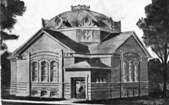 | Clare Congregational Church | building | 1994 | 94001424 |
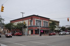 | Clare Downtown Historic District | district | 2016 | 16000178 |
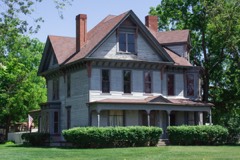 | George and Martha Hitchcock House | building | 1982 | 82002832 |
Every wildfire the federal occurrence database records inside this county: 544 of them, burning about 1,463 acres. 9 started naturally and 41 were recorded as arson. Each settlement page carries the fires within five miles of it.
| Reported cause | Fires |
|---|---|
| Debris and open burning | 175 |
| Missing data/not specified/undetermined | 115 |
| Equipment and vehicle use | 77 |
| Arson/incendiarism | 41 |
| Recreation and ceremony | 39 |
| Misuse of fire by a minor | 23 |
| Smoking | 18 |
| Railroad operations and maintenance | 17 |
| Power generation/transmission/distribution | 16 |
| Fireworks | 11 |
| Natural | 9 |
| Other causes | 3 |
The five largest, by the area the report gives. One of them was set deliberately.
| Date | Cause | Size | Reported by | Name on the report |
|---|---|---|---|---|
| 5 April 2005 | Missing data/not specified/undetermined | 62 acres | Michigan Department of Natural Resources | not named |
| 2 April 2005 | Arson/incendiarism | 50 acres | Michigan Department of Natural Resources | not named |
| 2 April 2010 | Smoking | 43 acres | Michigan Department of Natural Resources | CLARE 07 |
| 12 March 2003 | Debris and open burning | 40 acres | Michigan Department of Natural Resources | not named |
| 11 April 2002 | Railroad operations and maintenance | 40 acres | Michigan Department of Natural Resources | not named |
| 9 April 1994 | Misuse of fire by a minor | 33 acres | Michigan Department of Natural Resources | not named |
| 21 March 1996 | Missing data/not specified/undetermined | 30 acres | Michigan Department of Natural Resources | not named |
| 22 May 1994 | Missing data/not specified/undetermined | 26 acres | Michigan Department of Natural Resources | not named |
Every settlement page carries the fires within five miles of it - see the settlement index below.
The NOAA Storm Events Database holds 125 reports for this county, causing no deaths, 2 injuries and about $7,269,500 in recorded property damage. Each settlement page carries the reports that name it.
| Kind of event | Reports |
|---|---|
| Thunderstorm Wind | 69 |
| Hail | 39 |
| Tornado | 10 |
| Flash Flood | 5 |
| Lightning | 1 |
| Flood | 1 |
The most serious of them, by death, then injury, then recorded damage. The accounts are quoted exactly as the forecast office filed them.
| When | Event | Place named | Harm | What the report says |
|---|---|---|---|---|
| November 2013 | Thunderstorm Wind | Harrison | 1 hurt, $75,000 | Several trees and power lines were blown down and one person was injured by a falling tree. Part of US-10 was blocked by several downed large trees and one tree fell on a house. |
| June 1994 | Thunderstorm Wind | Hamilton Township | 1 hurt, $50,000 | A barn and silo were damaged. A travel trailer was damaged by fallen trees. One man was injured when a tree fell on his vehicle. Sheriff Department received reports of tornadoes, but none were confirmed. |
| April 2013 | Flood | Leota | $3,000,000 | Significant flooding occurred on rivers and streams across Clare county. |
| July 2024 | Tornado (EF1) | Lake George | $2,000,000 | The first indications of tornado damage were near Bringold Avenue about one-third of a mile south of Mannsiding Road. The tornado traveled east northeast across Lake George and continued east near Cedar Road and continued on to the east northeast |crossing US-127 and ending just south of the intersection of East Gladwin Road and South Rodgers Avenue.||The damage included boats flipped on Lake George as well as hundreds of|trees downed along the path - including some trees falling onto homes.|There was a concentrated area of damage where winds were estimated|at 95 mph just east of Old State Road about one-quarter mile south|of Mannsiding Road. After that, the damage became intermittent and|weaker with some pockets of 65-80 mph damage. |
| September 1998 | Hail | Leota | $300,000 | 1.75 to 3 inch hail damaged buildings and vehicles damage amount is unknown. |
| April 2020 | Hail | Lake | $250,000 | Large hail up to one and three quarters inches in diameter was reported near Clare. |
| August 2018 | Thunderstorm Wind | Leota | $200,000 | Numerous trees were uprooted or snapped and there was damage to buldings and vehicles due to fallen trees. Leota was especially hard hit. |
| October 1998 | Tornado (F0) | Clare | $200,000 | Tornado continued into Clare County then lifted and moved ne |
| June 2021 | Tornado (EF0) | Dover | $100,000 | An NWS storm survey concluded that an EF-0 tornado occurred with a path length of about a hundred yards. The upwind side of a barn wall was partly caved in. Tree limbs were snapped and a house attachment or garage-like structure on cinderblocks was destroyed. One large and healthy tree northeast of the garage-like structure damage and along the centerline of the tornado track was completely delimbed. Elsewhere, there were trees snapped or sheared. Near the end of the path a section of metal roofing was torn off a barn. |
| May 2001 | Flash Flood | Countywide | $100,000 | no account filed |
| August 2024 | Thunderstorm Wind | Clare | $75,000 | A large tree fell on several parked cars. |
| July 2024 | Thunderstorm Wind | Harrison | $50,000 | Numerous trees and power lines were blown down. |
| September 2021 | Thunderstorm Wind | Lake George | $50,000 | Several trees and power lines were blown down near Lake George and Arthur Avenues and around Lake George. |
| May 1999 | Thunderstorm Wind | Harrison | $50,000 | Large trees and some power lines were downed by gusty winds in Harrison. |
| May 1998 | Thunderstorm Wind | Temple | $50,000 | Numerous trees and power lines were downed across Clare County and one home was damaged. No injuries were reported. Damages were estimated at $50,000. |
| July 1995 | Thunderstorm Wind | Harrison to | $50,000 | Numerous trees were uprooted or blown down due to high thunderstorm winds from Harrison to Meredith in north central and northeast Clare County. |
| August 2002 | Thunderstorm Wind | Leota | $50,000 | no account filed |
| July 2003 | Hail | Leota | $40,000 | One and three quarters inch diameter hail was reported in Meredith and Leota. |
| June 2003 | Hail | Clare | $30,000 | A report of one inch diameter hail was received from Clare. |
| July 2005 | Thunderstorm Wind | Lake | $30,000 | no account filed |
| May 2000 | Hail | Harrison | $30,000 | no account filed |
| June 2024 | Thunderstorm Wind | Leota | $25,000 | Several large trees were blown down. |
| July 2017 | Thunderstorm Wind | Leota | $25,000 | The Clare county road commission indicated numerous trees were blown down over roads, especially in Winterfield township. |
| July 2012 | Thunderstorm Wind | Clare | $25,000 | A tree was blown down onto a house in Clare. |
| June 2001 | Thunderstorm Wind | Leota | $25,000 | no account filed |
| May 2001 | Flash Flood | Countywide | $25,000 | no account filed |
| June 1987 | Tornado (F1) | not stated | $25,000 | no account filed |
| March 1976 | Tornado (F1) | not stated | $25,000 | no account filed |
| August 2015 | Thunderstorm Wind | Harrison | $20,000 | Scattered areas of downed trees were reported across portions of Clare county. |
| July 2003 | Thunderstorm Wind | Lake George | $20,000 | Several trees were blown down across Lincoln township in Clare county. Six trees were blown down at the intersection of Cranberry Lake Road and Harding Avenue. |
| August 2000 | Hail | Lake | $20,000 | no account filed |
| September 2000 | Thunderstorm Wind | Harrison | $20,000 | no account filed |
| June 2016 | Thunderstorm Wind | Browns Corner | $15,000 | A trained spotter reported that numerous healthy poplar trees of around a foot and a half in diameter were blown down onto portions of Route 127 near Snow Snake Ski and Golf. Several trees were also blown down on the golf course. |
| June 2005 | Thunderstorm Wind | Harrison | $15,000 | Law enforcement reported that the back side of a barn was blown out with numerous trees down near the intersection of Hemlock Avenue and Clarence Road. |
| July 2003 | Thunderstorm Wind | Temple | $15,000 | A report of up to two dozen ten to twelve inch diameter oak and elm trees being blown down was received from five miles east northeast of Temple along Bringold Avenue. |
| June 1999 | Thunderstorm Wind | Farwell | $15,000 | Several trees were blown down and power lines were also downed in Farwell. |
| September 2001 | Thunderstorm Wind | Leota | $15,000 | no account filed |
| July 2023 | Thunderstorm Wind | Harrison | $10,000 | A state official reported that several trees were blown down near Harrison. |
| June 2021 | Thunderstorm Wind | Harrison | $10,000 | Multiple trees were blown down five miles east of Harrison. |
| June 2021 | Thunderstorm Wind | Farwell | $10,000 | Several trees were blown down in and near Farwell. |
| July 2018 | Thunderstorm Wind | Lake | $10,000 | A few trees and power lines were blown down in Garfield township. |
| July 2014 | Hail | Farwell | $10,000 | The public reported hail up to one and three quarters inch in diameter near Farwell. |
| July 2007 | Hail | Farwell | $10,000 | One inch diameter hail was reported at Clare and seven eighths inch diameter hail was reported at Farwell. |
| June 2005 | Hail | Harrison | $10,000 | One inch diameter hail was reported six miles northeast of Harrison. |
| May 2004 | Hail | Lake George | $10,000 | Three quarters inch hail was reported by the public in Lake George. |
| May 2001 | Tornado (F0) | Browns Corner | $10,000 | A F0 tornado briefly touched down in Browns Corners. It had a path length of only a tenth of a mile, and a width of 30 yards. The only damage observed was to a few trees. |
| February 1999 | Thunderstorm Wind | Clare | $10,000 | A 60 mile per hour wind gust was reported and some trees were downed. |
| September 2016 | Thunderstorm Wind | Harrison | $5,000 | A 911 call center reported that several trees were blown down near Budd Lake. |
| October 2007 | Thunderstorm Wind | Dover | $5,000 | Several trees and power lines were blown down by wind gusts estimated at 60 mph. |
| October 2007 | Thunderstorm Wind | Lake | $5,000 | Several trees and power were blown down by wind gusts estimated at 60 mph. |
| June 2006 | Hail | Clare | $5,000 | Three quarters inch hail was reported by amateur radio operators in Clare. |
| August 2005 | Thunderstorm Wind | Harrison | $5,000 | Three trees were blown down in Hayes and Surrey townships. |
| September 1998 | Thunderstorm Wind | Harrison | $5,000 | Wind Damage to homes and trees 4 NE Harrrison. |
| September 1997 | Thunderstorm Wind | Clare | $5,000 | Clare County Central Dispatch reported trees and power lines downed in and around the city of Clare at 2:00 PM EDT. |
| September 1997 | Thunderstorm Wind | Farwell | $5,000 | Clare County Central Dispatch reported trees were downed in Farwell at 2:20 PM EDT. |
| August 1995 | Thunderstorm Wind | Clare | $5,000 | Thunderstorm winds knocked down a few large trees up to one foot in diameter just east of U.S. 27, causing minimal structural damage to a mobile home. |
| July 1996 | Lightning | Temple | $5,000 | no account filed |
| July 2016 | Thunderstorm Wind | Lake George | $4,000 | Two trees were blown down near Lake George in the area of Clarence Rd. and Bringold Ave. |
| June 1997 | Thunderstorm Wind | Lake George | $2,500 | One tree reported downed near M-115 in southwest Clare County. Other trees were downed across county from this severe thunderstorm. |
| September 2001 | Thunderstorm Wind | Harrison | $2,000 | no account filed |
The Survey's mineral resources record lists 9 workings inside this county. 5 still produce and 4 are closed or unrecorded. Each settlement page carries the workings within five miles of it.
| Commodity | Workings |
|---|---|
| Sand and Gravel, Construction | 7 |
| Clay | 2 |
The least common of them first, because a county's hundredth gravel pit says nothing its first ten did not.
| Where | Site | Commodity | Status | Recorded |
|---|---|---|---|---|
| Clare Prtlnd Cmnt Co Clay Prospect | Clay | Prospect | ||
| McKenna Clay Pit | Clay | Past Producer | ||
| Larman Pit & Mill | Sand and Gravel, Construction | Producer | ||
| Loomis Pit | Sand and Gravel, Construction | Producer | ||
| Martz Pit & Mill | Sand and Gravel, Construction | Past Producer | ||
| Mcculloch Pit & Mill | Sand and Gravel, Construction | Producer | ||
| Mcquestion Pit & Mill | Sand and Gravel, Construction | Producer | ||
| Shively Pit & Mill | Sand and Gravel, Construction | Producer | ||
| Weldon Pit & Mill | Sand and Gravel, Construction | Unknown |
Named settlements recorded in the Geographic Names Information System, each with the topographic sheets covering it. Villages, hamlets and abandoned places alike. Each is shown with the nearest named watercourse or landform and the survey quadrangle it falls on.
Hayes township · 48625 · On Spike Horn Creek · Harrison quadrangle
11 sheets, 1954 to 1989
Frost township · 48625 · On South Branch Town Line Creek · Cooperton quadrangle
11 sheets, 1954 to 1989
Summerfield township · 48625 · On Cranberry Creek · Moddersville quadrangle
12 sheets, 1954 to 1989
Redding township · 48625 · On Little Norway Creek · Temple quadrangle
11 sheets, 1954 to 1989