 Block
From the record
3 National Register listings published here.
Sources: the National Register database, National Park Service
30 topographic sheets cover 29 settlements here, and 3 properties are on the National Register of Historic Places.
3 National Register listings published here.
Sources: the National Register database, National Park Service
Every property in this county listed on the National Register of Historic Places, with the year it was listed and the federal nomination document.
| Photograph | Property | Type | Listed | Reference |
|---|---|---|---|---|
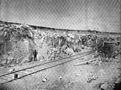 | Alabaster Historic District | district | 1977 | 77000715 |
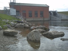 | Cooke Hydroelectric Plant | district | 1996 | 96000803 |
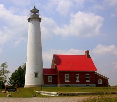 | Tawas Point Light Station | building | 1984 | 84001453 |
Every wildfire the federal occurrence database records inside this county: 655 of them, burning about 2,840 acres. 10 started naturally and 69 were recorded as arson. Each settlement page carries the fires within five miles of it.
| Reported cause | Fires |
|---|---|
| Debris and open burning | 184 |
| Missing data/not specified/undetermined | 138 |
| Recreation and ceremony | 82 |
| Power generation/transmission/distribution | 69 |
| Arson/incendiarism | 69 |
| Equipment and vehicle use | 43 |
| Smoking | 21 |
| Misuse of fire by a minor | 19 |
| Fireworks | 11 |
| Natural | 10 |
| Other causes | 5 |
| Railroad operations and maintenance | 4 |
The five largest, by the area the report gives. Two of them were set deliberately.
| Date | Cause | Size | Reported by | Name on the report |
|---|---|---|---|---|
| 28 April 2003 | Arson/incendiarism | 531 acres | Huron-Manistee National Forest | ALDRICH ROAD |
| 24 April 2010 | Missing data/not specified/undetermined | 270 acres | Huron-Manistee National Forest | EXHAUST |
| 2 June 1998 | Natural | 125 acres | Huron-Manistee National Forest | TUTTLE MARSH |
| 25 March 2000 | Power generation/transmission/distribution | 74 acres | Huron-Manistee National Forest | 4411 |
| 23 July 1998 | Recreation and ceremony | 68 acres | Huron-Manistee National Forest | AIRPORT |
| 18 May 1998 | Arson/incendiarism | 62 acres | Huron-Manistee National Forest | FUELBREAK |
| 27 April 2003 | Recreation and ceremony | 52 acres | Huron-Manistee National Forest | VAUGHN CREEK |
| 29 April 2004 | Equipment and vehicle use | 52 acres | Michigan Department of Natural Resources | not named |
Every settlement page carries the fires within five miles of it - see the settlement index below.
The NOAA Storm Events Database holds 164 reports for this county, causing 4 deaths, 20 injuries and about $7,298,253 in recorded property damage. Each settlement page carries the reports that name it.
| Kind of event | Reports |
|---|---|
| Thunderstorm Wind | 74 |
| Hail | 71 |
| Tornado | 14 |
| Lightning | 3 |
| Flash Flood | 1 |
| Flood | 1 |
The most serious of them, by death, then injury, then recorded damage. The accounts are quoted exactly as the forecast office filed them.
| When | Event | Place named | Harm | What the report says |
|---|---|---|---|---|
| June 1953 | Tornado (F2) | not stated | 4 killed, 13 hurt, $250,000 | no account filed |
| July 2003 | Lightning | Oscoda | 4 hurt, $10,000 | Lightning struck a large business sign mounted on a tall pole. The heavy plastic facing of the sign shattered and fell onto vehicles below. One car with four occupants had its windows shattered and tires blown out by the impact. The occupants were treated at the scene by an EMS crew for cuts and bruises. Other vehicles in the vicinity were damaged, but not as severely. |
| July 2007 | Lightning | Tawas City | 2 hurt | Two canoers, one male and one female, were struck by lightning while taking shelter under a tree during a thunderstorm. The woman was knocked unconscious, and both suffered significant burns. They were transported to a burn center in Flint to recover. |
| July 2019 | Thunderstorm Wind | Hale | 1 hurt, $18,000 | Multiple trees were downed. One tree was downed onto an occupied vehicle, injuring an occupant. |
| March 1991 | Tornado (F3) | not stated | $2,500,000 | no account filed |
| March 1991 | Tornado (F3) | not stated | $2,500,000 | no account filed |
| May 2020 | Flood | Alabaster | $1,200,000 | Widespread areal flooding developed in central and southern Iosco County on the 18th. Many creeks and rivers rose out of their banks, including the Au Gres River system and Silver Creek and its tributaries. Many roads across the county were closed, including Meadow Road in Tawas City. Railroad tracks were also washed out in Tawas City. Townline Road in Tawas Township was washed out by Dead Creek. Flooding along the Lake Huron coastline was worsened by lakeshore flooding thanks to onshore winds. |
| June 1982 | Tornado (F1) | not stated | $250,000 | no account filed |
| June 2014 | Tornado (EF1) | Hale | $140,000 | The tornado caused sporadic but considerable tree damage along its path. When it crossed the town of Hale, several high-profile vehicles were blown over, numerous utility poles were blown over, and several homes and businesses sustained roof damage. Estimated peak winds were 100 mph. |
| August 2011 | Tornado (EF0) | Alabaster Jct | $75,000 | Several people witnessed the tornado touch down between US-23 and Tawas Bay. The tornado was on the ground for less than a quarter-mile, crossing Douglas Drive just north of Lakeview Drive, before reaching the bay as a waterspout. Forty trees were downed, and six homes suffered damage, mostly roof damage due to those falling trees. Winds were estimated at 70 mph. |
| July 2006 | Thunderstorm Wind | (Osc)Wurtsmith Afb O | $25,000 | Considerable tree damage extended from just upstream of Cooke Dam to the upper reaches of the Foote Dam Pond. Many trees knocked over at the Sawmill Point Campground in the Huron National Forest. A sign, a boat trailer, and a camper were all destroyed or heavily damaged by fallen trees. |
| July 2003 | Thunderstorm Wind | Oscoda | $25,000 | Trees and utility lines were downed. A business sign was blown down, damaging nearby parked cars. |
| May 1983 | Tornado (F0) | not stated | $25,000 | no account filed |
| June 1981 | Tornado (F1) | not stated | $25,000 | no account filed |
| August 1977 | Tornado (F1) | not stated | $25,000 | no account filed |
| August 1977 | Tornado (F1) | not stated | $25,000 | no account filed |
| March 1976 | Tornado (F1) | not stated | $25,000 | no account filed |
| July 2006 | Thunderstorm Wind | Tawas City | $20,000 | Numerous trees and power lines downed. Camper trailer flipped over. |
| May 2018 | Thunderstorm Wind | East Tawas Iosco Arp | $16,000 | Scattered patches of trees and power lines downed in central Iosco County. |
| July 2020 | Thunderstorm Wind | National City | $15,000 | A tree was downed onto a truck. |
| July 2019 | Thunderstorm Wind | Sand Lake | $12,000 | Multiple trees, tree limbs and power lines were downed. One road northeast of Sand Lake was blocked. |
| June 2008 | Thunderstorm Wind | Tawas City | $12,000 | Numerous trees and power lines downed in and west of Tawas City. |
| July 2006 | Thunderstorm Wind | East Tawas | $10,000 | Metal roof blown off a barn. |
| September 2001 | Thunderstorm Wind | Hale | $10,000 | Scattered strong to severe thunderstorms developed along a cold front. A couple of storms uprooted 1 and 2 foot diameter trees in Hale. In addition, several roofs were damaged and a tin building was destroyed. |
| June 2015 | Thunderstorm Wind | Tawas City | $6,000 | Several trees were uprooted along River Street in Tawas City. |
| August 2015 | Thunderstorm Wind | Whittemore | $6,000 | Trees were downed by damaging winds. |
| November 2013 | Thunderstorm Wind | Whittemore | $6,000 | Multiple trees were downed. |
| May 2012 | Thunderstorm Wind | Hale | $6,000 | Numerous large oak trees trees were uprooted near the Alcona and Iosco County line. |
| July 2020 | Thunderstorm Wind | East Tawas Iosco Arp | $5,000 | Numerous trees were downed near Wilber. |
| July 2019 | Thunderstorm Wind | National City | $5,000 | Trees and large tree limbs were downed. |
| November 2013 | Thunderstorm Wind | Hale | $5,000 | Several trees were downed. |
| April 2011 | Lightning | Tawas City | $5,000 | Lightning struck a pine tree, which toppled onto a home, and catching the home on fire. |
| May 1995 | Tornado (F1) | Saint Clair | $5,000 | A tornado touched down and remained on the ground for a couple of minutes. While on the ground it destroyed a small barn, peeled siding off of a house, and destroyed a high voltage tower. |
| May 2013 | Thunderstorm Wind | Long Lake | $4,000 | A number of trees were downed. |
| July 2010 | Thunderstorm Wind | Whittemore | $4,000 | Trees and power lines were downed in far southern Iosco County. |
| June 2008 | Thunderstorm Wind | Hemlock | $4,000 | Several trees were downed in Grant Township. |
| May 2013 | Thunderstorm Wind | Tawas City | $3,000 | Some tree limbs and numerous power lines were downed. |
| July 2003 | Flash Flood | Oscoda | $3,000 | Widespread street flooding occurred, with over six inches of water covering streets in the business district. Some basements also flooded. |
| August 2008 | Thunderstorm Wind | Hale | $2,500 | A few trees were downed. |
| August 2008 | Thunderstorm Wind | (Osc)Wurtsmith Afb O | $2,500 | A few trees were downed in Wilber Township. |
| April 2022 | Thunderstorm Wind | National City | $2,000 | Public report of a tree blown down on top of a structure. |
| August 2021 | Thunderstorm Wind | Sand Lake | $2,000 | Iosco county dispatch reports trees down near Sand Lake. |
| August 2021 | Thunderstorm Wind | Whittemore | $2,000 | Iosco county dispatch reports trees down near Whittemore. |
| August 2021 | Thunderstorm Wind | Tawas City | $2,000 | County dispatch reports trees down in Tawas. |
| July 2006 | Thunderstorm Wind | Oscoda | $2,000 | Trees downed across Cedar Road. |
| August 2005 | Thunderstorm Wind | Oscoda | $2,000 | A line of thunderstorms organized just before it moved offshore onto Lake Huron. Several trees were downed near Cedar Lake. |
| April 2022 | Thunderstorm Wind | Tawas City | $1,000 | County dispatch reported powerlines down in Tawas. Time estimated from radar. |
| June 1982 | Tornado (F0) | not stated | $250 | no account filed |
| April 1993 | Thunderstorm Wind | Whittemore | $3 | A spotter reported several large trees uprooted due to thunderstorm winds. |
| July 2025 | Thunderstorm Wind | East Tawas | - | Marine wind sensor on Tawas Bay reported wind gust to 60mph. |
| July 2024 | Thunderstorm Wind | Whittemore | - | Report of a camper blown over near Whittemore. |
| June 2020 | Thunderstorm Wind | East Tawas | - | Measured wind gust at Tawas Point. |
| July 2009 | Hail | East Tawas | - | Penny sized hail at Red Hawk Golf Course. |
| July 2008 | Hail | Long Lake | - | Hail covered the ground at a local golf course. |
| August 2008 | Thunderstorm Wind | Au Sable | - | A trained spotter estimated a 60 mph wind gust. |
| April 2008 | Hail | East Tawas | - | Mostly pea sized hail, but a few hailstones as large as nickels. |
| April 2006 | Hail | Tawas City | - | Thunderstorms affected Central Lower Michigan, just ahead of a cold front. Some of the storms produced small hail, and one produced hail as large as pennies near the intersection of M-65 and M-55 in Iosco County. |
| August 2004 | Thunderstorm Wind | Hale | - | Trees were downed. |
| August 2004 | Thunderstorm Wind | East Tawas | - | Several trees were downed. |
| July 2003 | Thunderstorm Wind | Tawas City | - | Large tree limbs were downed. |
The Survey's mineral resources record lists 12 workings inside this county. 7 still produce and 5 are closed or unrecorded. Each settlement page carries the workings within five miles of it.
| Commodity | Workings |
|---|---|
| Gypsum-Anhydrite | 9 |
| Clay | 2 |
| Sand and Gravel, Construction | 1 |
The least common of them first, because a county's hundredth gravel pit says nothing its first ten did not.
| Where | Site | Commodity | Status | Recorded |
|---|---|---|---|---|
| Burge Pit and Mill | Sand and Gravel, Construction | Producer | ||
| Tawas City Eastern Clay Pit | Clay | Past Producer | ||
| Tawas City Western Clay Pit | Clay | Past Producer | ||
| Alabaster Mine and Mill | Gypsum-Anhydrite | Producer | ||
| Alabaster Quarry | Gypsum-Anhydrite | Producer | 1865, 2001 | |
| Michigan Gypsum Co Pit | Gypsum-Anhydrite | Past Producer | ||
| Michigan Gypsum Pit & Mill | Gypsum-Anhydrite | Producer | 1960 | |
| Michigan Gypsum Pit and Mill | Gypsum-Anhydrite | Producer | ||
| National City Quarry | Gypsum-Anhydrite | Past Producer | 1925 | |
| National Pit & Mill | Gypsum-Anhydrite | Producer | ||
| Natl Gypsum Co Pit | Gypsum-Anhydrite | Past Producer | ||
| Tawas Quarry | Gypsum-Anhydrite | Producer | 1950 |
Named settlements recorded in the Geographic Names Information System, each with the topographic sheets covering it. Villages, hamlets and abandoned places alike. Each is shown with the nearest named watercourse or landform and the survey quadrangle it falls on.
Alabaster township · 48763 · On Mason Creek · Alabaster quadrangle
11 sheets, 1954 to 1984
Tawas township · 48763 · On Johns Creek · Alabaster quadrangle
11 sheets, 1954 to 1984
Au Sable Charter Township · 48750 · On Au Sable River · Oscoda quadrangle
13 sheets, 1954 to 1989
Alabaster township · 48763 · On Mason Creek · Alabaster quadrangle
11 sheets, 1954 to 1984
Alabaster township · 48763 · On Tawas River · Alabaster quadrangle
11 sheets, 1954 to 1984
Oscoda Charter Township · 48750 · Foote Site Village quadrangle
13 sheets, 1954 to 1989
Alabaster township · 48763 · On Mason Creek · Alabaster quadrangle
11 sheets, 1954 to 1984
Oscoda Charter Township · 48750 · Near Loud Island · Oscoda quadrangle
13 sheets, 1954 to 1989
Sherman township · 48748 · On Manary Creek · National City quadrangle
11 sheets, 1954 to 1984
Alabaster township · 48763 · On Mason Creek · Alabaster quadrangle
11 sheets, 1954 to 1984
Oscoda Charter Township · 48750 · On Van Etten Creek · Oscoda quadrangle
13 sheets, 1954 to 1989
Sherman township · 48765 · On Johnson Creek · National City quadrangle
11 sheets, 1954 to 1984
Wilber township · 48730 · On Loud Creek · Foote Site Village quadrangle
13 sheets, 1954 to 1989