 Block
From the record
4 National Register listings published here.
Sources: the National Register database, National Park Service
55 topographic sheets cover 16 settlements here, and 4 properties are on the National Register of Historic Places.
4 National Register listings published here.
Sources: the National Register database, National Park Service
Every property in this county listed on the National Register of Historic Places, with the year it was listed and the federal nomination document.
| Photograph | Property | Type | Listed | Reference |
|---|---|---|---|---|
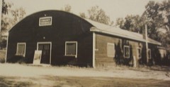 | Idlewild Historic District | district | 1979 | 79001160 |
| Idlewild Historic District (Boundary Increase) | district | 2010 | 09001062 | |
 | Marlborough Historic District | district | 1972 | 72000630 |
| John and Katharine Tunkun Podjun Farm | district | 2002 | 02000160 |
Every wildfire the federal occurrence database records inside this county: 686 of them, burning about 2,533 acres. 13 started naturally and 52 were recorded as arson. Each settlement page carries the fires within five miles of it.
| Reported cause | Fires |
|---|---|
| Debris and open burning | 268 |
| Missing data/not specified/undetermined | 127 |
| Power generation/transmission/distribution | 68 |
| Recreation and ceremony | 67 |
| Arson/incendiarism | 52 |
| Equipment and vehicle use | 38 |
| Misuse of fire by a minor | 17 |
| Natural | 13 |
| Fireworks | 12 |
| Smoking | 11 |
| Railroad operations and maintenance | 7 |
| Other causes | 6 |
The five largest, by the area the report gives. One of them was set deliberately.
| Date | Cause | Size | Reported by | Name on the report |
|---|---|---|---|---|
| 23 April 1994 | Recreation and ceremony | 910 acres | Huron-Manistee National Forest | COUNTY LINE |
| 9 May 2011 | Missing data/not specified/undetermined | 152 acres | Michigan Department of Natural Resources | LAKE 01 |
| 1 May 2010 | Natural | 118 acres | Huron-Manistee National Forest | NOUD LAKE |
| 6 July 1999 | Natural | 51 acres | Huron-Manistee National Forest | SOUTH JENKS |
| 14 May 2019 | Arson/incendiarism | 42 acres | Huron-Manistee National Forest | 8 MILE |
| 28 July 1998 | Missing data/not specified/undetermined | 40 acres | Huron-Manistee National Forest | BITELY |
| 4 June 1997 | Equipment and vehicle use | 40 acres | Huron-Manistee National Forest | CRASHING ROSES |
| 25 April 1998 | Missing data/not specified/undetermined | 40 acres | Huron-Manistee National Forest | 12 MILE |
Every settlement page carries the fires within five miles of it - see the settlement index below.
The NOAA Storm Events Database holds 79 reports for this county, causing no deaths, no injuries and about $8,638,000 in recorded property damage. Each settlement page carries the reports that name it.
| Kind of event | Reports |
|---|---|
| Thunderstorm Wind | 46 |
| Hail | 21 |
| Flash Flood | 6 |
| Tornado | 4 |
| Flood | 2 |
The most serious of them, by death, then injury, then recorded damage. The accounts are quoted exactly as the forecast office filed them.
| When | Event | Place named | Harm | What the report says |
|---|---|---|---|---|
| April 2013 | Flood | Irons | $3,000,000 | Significant flooding occurred on rivers and streams across Lake county due to significant rainfall from early to mid April. |
| June 2008 | Flash Flood | Peacock | $2,000,000 | Damage resulting from flash flooding included a 30 foot wide by 10 foot deep sinkhole which developed near the 18 Mile bridge five miles west of Irons. Numerous roads were washed out and several mudslides were also reported. ||Rainfall totals across the areas hardest hit ranged from five to eleven inches, all of which fell in only a six to eight hour time period. Damage to public infrastructure was estimated at about two million dollars, mainly due to all of the road and bridge washouts. A presidential disaster declaration for flooding was also issued for Lake county. |
| May 1998 | Thunderstorm Wind | Branch | $1,110,000 | Michigan State Police EMD's Damage and Injury Assessment Report indicated $89,176 in public damage costs and the Lake County Star newspaper reported $514,850 in private property damage and $502,500 in clean-up costs. No injuries were reported. Hardest hit townships included Lake, Peacock, and Yates. The newspaper reported an entanglement of trees, limbs, and power lines were left throughout the county, with the area from just south of Big Star Lake in Lake Township northeast through Idlewild having been especially hard-hit. Public buildings in Baldwin incurred minor damage and Michigan Highway 37, 4 miles south of Baldwin, was closed for a period on May 31st for tree and debris removal. Lake County declared a local state of emergency, which was lifted late in the day on Monday, June 1st. |
| July 2019 | Flood | Irons | $800,000 | Between 6 and 10 inches of rain fell with local reports of up to 12 inches of rain. This resulted in at least 48 homes across Lake county being affected by floodwaters. |
| July 2019 | Thunderstorm Wind | Wolf Lake | $250,000 | Numerous trees were blown down across much of Lake county. |
| July 2005 | Tornado (F1) | Baldwin | $150,000 | no account filed |
| June 2023 | Thunderstorm Wind | Branch | $100,000 | Several trees and power lines were downed across the county. |
| August 2018 | Tornado (EF0) | Baldwin | $100,000 | An EF-0 tornado with estimated max winds of 85 mph caused tree and property damage in the village of Baldwin. A few bulidings had collapsed walls, damage to siding, or loss of roofing material. |
| August 2018 | Tornado (EF1) | Baldwin Muni Arpt | $100,000 | An EF-1 tornado with maximum winds of 100 mph caused tree and property damage just east of the village of Baldwin near Idlewild. Tree damage was immense with trunks snapped in a narrow zone. |
| August 2013 | Thunderstorm Wind | Irons | $100,000 | Lake county emergency management reported that numerous trees were blown down throughout Lake county with widespread power outages. |
| August 2001 | Thunderstorm Wind | Baldwin | $100,000 | Very strong winds from a microburst brought down many trees and power lines across mainly the southern third of Lake county. In Idlewild, an area of trees a 100 yards long was blown down. |
| February 2001 | Flash Flood | Countywide | $100,000 | no account filed |
| August 2024 | Thunderstorm Wind | Baldwin Muni Arpt | $75,000 | A few trees and limbs were blown down and damaged vehicles in the area. |
| May 2012 | Flash Flood | Branch | $70,000 | Radar estimated that up to 5 to 7 inches of heavy rain fell across a fairly large part of Lake county resulting in several roads that were either flooded or washed out. |
| August 2021 | Thunderstorm Wind | Baldwin | $50,000 | Numerous trees and power lines were blown down in and near Baldwin. |
| November 2020 | Thunderstorm Wind | Baldwin | $50,000 | Multiple trees and power lines were blown down in and near Baldwin and Idlewild. |
| August 2000 | Hail | Luther | $50,000 | no account filed |
| August 2024 | Thunderstorm Wind | Baldwin | $25,000 | The public reported several large trees and limbs down near Big Star lake. |
| September 2021 | Hail | Baldwin | $25,000 | Hail up to two and a half inches in diameter was reported. |
| July 2005 | Thunderstorm Wind | Baldwin | $25,000 | no account filed |
| July 2005 | Thunderstorm Wind | Baldwin | $25,000 | no account filed |
| August 2001 | Thunderstorm Wind | Baldwin | $25,000 | no account filed |
| June 2000 | Thunderstorm Wind | Baldwin | $25,000 | no account filed |
| July 2000 | Thunderstorm Wind | Countywide | $25,000 | no account filed |
| April 2008 | Thunderstorm Wind | Irons | $20,000 | A Lake county official reported that several trees were blown down in and near the Irons area. |
| September 2005 | Thunderstorm Wind | Peacock | $20,000 | Numerous power lines and trees were blown down in Peacock. |
| June 2003 | Hail | Baldwin | $20,000 | Three quarters inch diameter hail was reported three miles south of Baldwin. |
| May 2000 | Hail | Baldwin | $20,000 | no account filed |
| May 2020 | Thunderstorm Wind | Idlewild | $10,000 | Several tree limbs were blown down in Yates township. |
| June 2020 | Thunderstorm Wind | Baldwin | $10,000 | Power outages were reported in Baldwin and law enforcement reported scattered trees down across the county. |
| July 2018 | Thunderstorm Wind | Baldwin | $10,000 | Law enforcement reported that several trees were blown down over portions of western Lake county. |
| July 2017 | Thunderstorm Wind | Little Manistee | $10,000 | A few trees were blown down in portions of Lake county. |
| June 2014 | Thunderstorm Wind | Baldwin | $10,000 | Lake county officials reported that several trees and power lines were blown down just south of Baldwin. |
| June 2014 | Thunderstorm Wind | Irons | $10,000 | The public reported that numerous trees were blown down on North Bass Lake Rd. south of 10 1/2 Mile Rd. |
| August 2011 | Flash Flood | Nirvana | $10,000 | Law enforcement reported flooding about 3 miles west of the town of Chase, where a 3 foot deep road washout occurred at 56th and Queens highway in Yates township. |
| July 2004 | Thunderstorm Wind | Irons | $10,000 | Several reports of trees and wires blown down were received from aorund Irons and the Big Bass Lake area. |
| August 2004 | Thunderstorm Wind | Chase | $10,000 | A couple of trees were blown down in Chase and one tree was blown down across M-37 two miles south of Baldwin. |
| May 2003 | Hail | Bristol | $10,000 | Seven eighths inch diameter hail was reported in Bristol. |
| May 2001 | Hail | Baldwin | $10,000 | An isolated severe thunderstorm developed over Baldwin in Lake county, producing three quarters inch hail in the town of Baldwin. Three quarters inch hail was also reported 2 miles west of Baldwin, also in Lake county. |
| July 1999 | Thunderstorm Wind | Irons | $10,000 | Trees were downed in Irons. |
| February 1999 | Thunderstorm Wind | Baldwin | $10,000 | A 60 mile per hour wind gust was reported in Baldwin, and 18" diameter trees were downed. |
| June 1999 | Thunderstorm Wind | Baldwin | $10,000 | Trees were downed by thunderstorm wind gusts in Baldwin. |
| August 1998 | Flash Flood | Northwest Portion | $10,000 | slow moving thunderstorms produced very heavy rain during the evening and overnight |
| May 1998 | Thunderstorm Wind | Irons | $10,000 | Trees and power lines downed in Irons. |
| May 2008 | Thunderstorm Wind | Baldwin Muni Arpt | $5,000 | An emergency manager reported that several trees were blown down at Big Star Lake. |
| July 2016 | Thunderstorm Wind | Irons | $4,000 | Severe storms brought down a couple of trees near Irons. |
| August 2005 | Thunderstorm Wind | Luther | $4,000 | Law enforcement in Luther reported two trees were blown down. |
| June 2007 | Thunderstorm Wind | Chase | $3,000 | Three trees were blown down one mile south of Chase. |
| May 1998 | Thunderstorm Wind | Baldwin | $1,000 | Large tree uprooted in Baldwin. |
| April 2002 | Thunderstorm Wind | Nirvana | $1,000 | no account filed |
| May 2025 | Thunderstorm Wind | Olivers | - | Several large trees down. |
| April 2025 | Hail | Little Manistee | - | Hail on 1.5 inches in diameter was reported. |
| July 2012 | Thunderstorm Wind | Baldwin | - | Law enforcement reported trees and power lines blown down in Baldwin. |
| April 2011 | Hail | Wolf Lake | - | Law enforcement near Wolf Lake reported hail the size of a quarter (one inch) in diameter. |
| June 2011 | Thunderstorm Wind | Wolf Lake | - | The storms that moved through Lake County produced reports of tree damage and subsevere hail. The hardest hit location appeared to be near the Wolf Lake area, where trees and power lines were downed and a report of hail estimated at 0.88 inch diameter fell. |
| July 2008 | Hail | Baldwin | - | A county official reported one inch diameter hail at the court house in Baldwin. |
| June 2008 | Thunderstorm Wind | Idlewild | - | Winds estimated at 60 to 70 mph blew down 50 to 60 trees, some of which blocked area roads. Three quarters of Lake county was reported to be without power after the storms. |
| March 1998 | Hail | Baldwin | - | The Lake County Sheriff's Department reported hail fell from 2:05 to 2:10 pm EST, ranging in size from one-half to one inch in diameter. |
| March 1998 | Hail | Baldwin | - | A local television station in Cadillac, MI, relayed a spotter report of 1.75 inch diameter hail approximately 3 miles southwest of Baldwin, in Pleasant Plains Township. |
| September 1998 | Hail | Wolf Lake | - | 3/4" hail produced by supercell moving east. |
The Survey's mineral resources record lists 8 workings inside this county. 7 still produce and 1 is closed or unrecorded. Each settlement page carries the workings within five miles of it.
| Commodity | Workings |
|---|---|
| Sand and Gravel, Construction | 7 |
| Clay | 1 |
The least common of them first, because a county's hundredth gravel pit says nothing its first ten did not.
| Where | Site | Commodity | Status | Recorded |
|---|---|---|---|---|
| Northern Cement Co Clay Pit | Clay | Past Producer | ||
| Fischer Pit and Mill | Sand and Gravel, Construction | Producer | ||
| Lake County Road Comm. Pit | Sand and Gravel, Construction | Producer | ||
| Lake County Road Comm. Pit | Sand and Gravel, Construction | Producer | ||
| Lake County Road Comm. Pit | Sand and Gravel, Construction | Producer | ||
| Lake Sand & Gravel Pit | Sand and Gravel, Construction | Producer | ||
| Leavitt Pit and Mill | Sand and Gravel, Construction | Producer | ||
| Webber Pit and Mill | Sand and Gravel, Construction | Producer |
Named settlements recorded in the Geographic Names Information System, each with the topographic sheets covering it. Villages, hamlets and abandoned places alike. Each is shown with the nearest named watercourse or landform and the survey quadrangle it falls on.
Pleasant Plains township · 49304 · On Baldwin River · Baldwin quadrangle
16 sheets, 1931 to 1991
Pleasant Plains township · 49304 · On Little South Branch Pere Marquette River · Marlborough quadrangle
15 sheets, 1954 to 1991