 Block
From the record
3 National Register listings published here.
Sources: the National Register database, National Park Service
47 topographic sheets cover 21 settlements here, and 3 properties are on the National Register of Historic Places.
3 National Register listings published here.
Sources: the National Register database, National Park Service
Every property in this county listed on the National Register of Historic Places, with the year it was listed and the federal nomination document.
| Photograph | Property | Type | Listed | Reference |
|---|---|---|---|---|
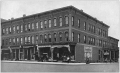 | Fairman Building | building | 1987 | 87000072 |
| Morgan West Wheatland Cemetery | site | 2014 | 14001044 | |
 | Nisbett Building | building | 1986 | 86003452 |
Every wildfire the federal occurrence database records inside this county: 201 of them, burning about 882 acres. 14 started naturally and 14 were recorded as arson. Each settlement page carries the fires within five miles of it.
| Reported cause | Fires |
|---|---|
| Missing data/not specified/undetermined | 65 |
| Equipment and vehicle use | 62 |
| Debris and open burning | 28 |
| Arson/incendiarism | 14 |
| Natural | 14 |
| Recreation and ceremony | 6 |
| Smoking | 5 |
| Misuse of fire by a minor | 3 |
| Other causes | 2 |
| Power generation/transmission/distribution | 2 |
The five largest, by the area the report gives. None of them was recorded as arson.
| Date | Cause | Size | Reported by | Name on the report |
|---|---|---|---|---|
| 10 April 2003 | Debris and open burning | 96 acres | Michigan Department of Natural Resources | not named |
| 4 March 2018 | Debris and open burning | 60 acres | Michigan Department of Natural Resources | MORTON TOWNSHIP FIRE/RESCUE 93 - 2018 |
| 22 May 2018 | Debris and open burning | 47 acres | Michigan Department of Natural Resources | MECOSTA 01 |
| 1 April 1994 | Debris and open burning | 40 acres | Michigan Department of Natural Resources | not named |
| 23 April 1994 | Debris and open burning | 37 acres | Michigan Department of Natural Resources | not named |
| 3 April 1994 | Debris and open burning | 33 acres | Michigan Department of Natural Resources | not named |
| 26 March 1995 | Smoking | 31 acres | Michigan Department of Natural Resources | not named |
| 13 April 2003 | Debris and open burning | 25 acres | Michigan Department of Natural Resources | not named |
Every settlement page carries the fires within five miles of it - see the settlement index below.
The NOAA Storm Events Database holds 132 reports for this county, causing no deaths, 26 injuries and about $18,368,140 in recorded property damage. Each settlement page carries the reports that name it.
| Kind of event | Reports |
|---|---|
| Thunderstorm Wind | 69 |
| Hail | 39 |
| Tornado | 11 |
| Flash Flood | 7 |
| Flood | 4 |
| Lightning | 2 |
The most serious of them, by death, then injury, then recorded damage. The accounts are quoted exactly as the forecast office filed them.
| When | Event | Place named | Harm | What the report says |
|---|---|---|---|---|
| October 1998 | Tornado (F1) | Big Rapids | 12 hurt, $1,200,000 | Tornado touched down on Ferris State University in Big Rapids, 7 students injured, 5 others treated at a local hospital for minor injuries. The most serious injury was a broken arm. |
| April 1968 | Tornado (F3) | not stated | 8 hurt, $2,500,000 | no account filed |
| July 2009 | Lightning | Big Rapids | 4 hurt | A non severe morning thunderstorm produced lightning that struck pine trees very close to where four construction workers were standing, injuring all of them. This occurred at Ferris State University in Big Rapids. |
| June 1974 | Tornado (F2) | not stated | 2 hurt, $250,000 | no account filed |
| January 2013 | Flood | Paris | $4,600,000 | A significant ice jam on the Muskegon River resulted in evacuations of over a dozen homes along the Muskegon River near Rogers Heights, all of which were flooded. Riverside Drive and 183rd Avenue (12th Mile Road) in particular were local areas of particularly significant flooding. |
| April 2013 | Flood | Paris | $3,000,000 | Significant flooding occurred on rivers and streams across Mecosta county due to significant rainfall from early to mid April. |
| May 2022 | Flood | Big Rapids | $2,500,000 | Flooding from heavy rain resulted in road closures and damage to roads, bridges and culverts in Big Rapids with businesses and public spaces impacted. Ferris State University had multiple buildings take on water. |
| April 2011 | Flash Flood | Morley Howe Arpt | $1,000,000 | A local State of Emergency was declared for Mecosta County as a result of extensive heavy rainfall and melting snow during the early morning hours of April 4, 2011, causing widespread flood damage to public and individual property. Numerous roads were washed out and/or covered with water. A significant thoroughfare, M-20, was temporarily closed when overflow from Schrader Creek resulted in 6 inches of moving water over the road. Over a dozen homes along Harding Road and 17 Mile were surrounded by water, with several homes with water up to their foundations. |
| April 2014 | Thunderstorm Wind | Mecosta | $500,000 | Emergency management reported that numerous trees were blown down with power outages in Big Rapids and that a trailer was blown over. |
| April 2020 | Hail | Morley | $250,000 | The public reported very large hail up to one and three quarters inches in diameter across portions of Mecosta county. |
| August 2011 | Flash Flood | Big Rapids | $250,000 | Cars floated in flood waters on State street in Big Rapids as reported by emergency management. County emergency management also reported that numerous other roads in and near Big Rapids experienced some flooding. ||One of the washed out roads stranded over 800 Boy Scouts at a local camp in Mecosta County. Ferris State University in Big Rapids, Michigan reported 25 buildings on campus with water damage. |
| June 1985 | Tornado (F2) | not stated | $250,000 | no account filed |
| August 2018 | Thunderstorm Wind | Stanwood Cain Arpt | $200,000 | Damage from thunderstorm winds estimated at 75-90 mph stretched from Paris to Big Rapids to Stanwood. Numerous downed trees and damage to property from falling trees was found with the worst damage northwest of Stanwood. |
| September 2018 | Tornado (EF0) | Rustford | $150,000 | The tornado occurred over rural parts of Mecosta county. A manufactured home was destroyed at the start of the damage path near Washington Road and 137th Avenue. The tornado then snapped trees along Washington Road before lifting at 125th Avenue. |
| May 2024 | Thunderstorm Wind | Morley Howe Arpt | $100,000 | Numerous trees and power lines were blown down by severe thunderstorm wind gusts. |
| August 2022 | Thunderstorm Wind | Rodney | $100,000 | Numerous trees were blown down across Mecosta county. |
| June 2021 | Tornado (EF1) | Sylvester | $100,000 | A NWS storm survey determined that an EF-1 tornado occurred with a path length of about 3 miles. A wood-sided barn was destroyed just south of the 80th Avenue and 5 Mile intersection. The tornado passed over the power substation at 75th Avenue and 5 mile and then proceeded northeast through a field where a center pivot irrigator was tipped over. Along 70th Avenue, between 5 Mile and 6 Mile, an open-air animal barn was torn apart with sheet metal deposited in the field downwind. Additionally, power poles were impacted by barn debris and consequently snapped, and another center pivot irrigator was tipped over. |
| May 1998 | Thunderstorm Wind | Paris | $86,600 | Michigan State Police EMD's Damage and Injury Assessment Report indicated $86,620 in public damage costs, 110+ homes damaged, and 3 businesses damaged in Mecosta County. Widespread tree and power line damage was reported across the county and power was cut to approximately 75% of the county's population. Private damage estimates were not available. No injuries were reported in Mecosta County. Mecosta County declared a local state of emergency and was granted a Governor's disaster declaration to activate state assistance for the county. |
| May 2020 | Flood | Barryton | $75,000 | The Chippewa Vista subdivision had some flooding due to flooding on the Chippewa River near Barryton. |
| June 2023 | Thunderstorm Wind | Mecosta Arpt | $50,000 | Several trees were blown down across the county. |
| November 2013 | Thunderstorm Wind | Mecosta Morton Arpt | $50,000 | An amateur radio operator reported significant tree and structural damage on 80th avenue between M20 and Garfield. Boats were also flipped in a boat yard. |
| September 2010 | Hail | Morley | $50,000 | The fire department reported golf ball sized hail in Morley. |
| June 1997 | Thunderstorm Wind | Big Rapids | $50,000 | A wet microburst downed nearly a dozen large trees and 5 utility poles in the city of Big Rapids. No structural damage was reported to homes or businesses, but downed trees damaged 3 vehicles. Three traffic lights were knocked from their cables and approximately 2,400 Consumers Energy customers lost power. No injuries were reported. |
| July 1994 | Thunderstorm Wind | Mecosta | $50,000 | Major damage to many boats was caused by nearby falling trees. Structural damage to the marina buildings was also observed. |
| July 2006 | Thunderstorm Wind | Big Rapids | $50,000 | no account filed |
| April 2001 | Hail | Big Rapids | $50,000 | no account filed |
| May 2001 | Flash Flood | Countywide | $50,000 | no account filed |
| May 2001 | Flash Flood | Countywide | $50,000 | no account filed |
| June 2000 | Thunderstorm Wind | Big Rapids | $50,000 | no account filed |
| April 1996 | Lightning | Big Rapids | $50,000 | no account filed |
| July 2003 | Hail | Big Rapids | $40,000 | Reports of seven eights inch to one inch diameter hail were received in Big Rapids. |
| July 2005 | Thunderstorm Wind | Rodney | $40,000 | no account filed |
| June 2024 | Thunderstorm Wind | Stanwood | $25,000 | Some wind damage and hail was reported near Stanwood. |
| August 2024 | Thunderstorm Wind | Big Rapids Arpt | $25,000 | Several large limbs and trees were blown down near Big Rapids. |
| June 2023 | Thunderstorm Wind | Morley | $25,000 | Multiple trees and limbs were blown down. |
| August 2018 | Thunderstorm Wind | Diamond Lake | $25,000 | An isolated afternoon severe thunderstorm brought down numerous trees and power lines across portions of Mecosta county. The most significant damage occurred near Horse Head Lake. |
| December 2007 | Thunderstorm Wind | Big Rapids | $25,000 | Power lines were blown down in Big Rapids township. |
| December 2007 | Thunderstorm Wind | Big Rapids | $25,000 | Power lines were blown down in Big Rapids township. |
| July 2003 | Hail | Rodney | $25,000 | One inch diameter hail was reported in Rodney, and hail briefly covered the ground. |
| July 2005 | Thunderstorm Wind | Rodney | $25,000 | no account filed |
| May 2001 | Flash Flood | Countywide | $25,000 | no account filed |
| July 2001 | Hail | Barryton | $25,000 | no account filed |
| August 2001 | Thunderstorm Wind | Countywide | $25,000 | no account filed |
| April 1966 | Tornado (F2) | not stated | $25,000 | no account filed |
| June 2005 | Flash Flood | Chippewa Lake | $20,000 | A thunderstorm intensified and began to back build over Mecosta County. For this event radar estimated a maximum storm total precipitation of 7.3 inches, of which, approximately 6.5 inches of the storm total fell over a two hour period. A "ground truth" report of 5.25 inches of rain in approximately 2 hours was received from the public the following day from the north side of Chippewa Lake. Significant flooding occurred in Mecosta County with several roads underwater and the shoulders of many roads in the area washed out. |
| June 2003 | Hail | Barryton | $20,000 | A report of three quarters inch hail was received from Barryton. |
| July 2005 | Thunderstorm Wind | Mecosta | $20,000 | no account filed |
| June 2006 | Hail | Rodney | $15,000 | One inch diameter hail was reported by the media in Rodney. |
| July 2006 | Hail | Sylvester | $15,000 | Three quarters inch hail was reported near Sylvester. |
| July 2006 | Hail | Big Rapids | $15,000 | One inch hail was reported by the public in Big Rapids. |
| September 2006 | Hail | Morley | $15,000 | One inch diameter hail was reported in Morley. |
| June 2005 | Thunderstorm Wind | Barryton | $15,000 | Law enforcement reported several trees blown down in Barryton. |
| June 2024 | Thunderstorm Wind | Stanwood Cain Arpt | $10,000 | Several power lines and trees were blown down near Big Rapids. |
| June 2020 | Thunderstorm Wind | Big Rapids | $10,000 | Several trees were blown down. |
| July 2014 | Thunderstorm Wind | Remus | $10,000 | A few trees were blown down near Remus. |
| July 2007 | Thunderstorm Wind | Paris | $10,000 | One tree was blown down in Paris and another was blown down in Big Rapids. |
| September 2006 | Hail | Stanwood | $10,000 | Law enforcement reported three quarters inch diameter hail five miles north of Stanwood. |
| October 2006 | Hail | Morley | $10,000 | Three quarters inch hail was reported in Morley. |
| July 2004 | Thunderstorm Wind | Barryton | $10,000 | An emergency manager reported that numerous trees were blown down about 9 miles west of Barryton. |
| July 1999 | Thunderstorm Wind | Morley | $10,000 | Several trees were downed in Morley. |
The Survey's mineral resources record lists 12 workings inside this county. 10 still produce and 2 are closed or unrecorded. Each settlement page carries the workings within five miles of it.
| Commodity | Workings |
|---|---|
| Sand and Gravel, Construction | 10 |
| Fire Clay (Refractory) | 1 |
| Potassium | 1 |
The least common of them first, because a county's hundredth gravel pit says nothing its first ten did not.
| Where | Site | Commodity | Status | Recorded |
|---|---|---|---|---|
| Big Rapids | Potassium | Prospect | ||
| Nehmer's Clay Pit | Fire Clay (Refractory) | Past Producer | ||
| Mecosta County Road Comm. Pit | Sand and Gravel, Construction | Producer | ||
| Mecosta County Road Comm. Pit | Sand and Gravel, Construction | Producer | ||
| Mecosta County Road Comm. Pit | Sand and Gravel, Construction | Producer | ||
| Mecosta County Road Comm. Pit | Sand and Gravel, Construction | Producer | ||
| Mecosta County Road Comm. Pit | Sand and Gravel, Construction | Producer | ||
| Mecosta County Road Comm. Pit | Sand and Gravel, Construction | Producer | ||
| Paris Pit No. 2 | Sand and Gravel, Construction | Producer | ||
| Pit Number 1 | Sand and Gravel, Construction | Producer | ||
| Sand Products Corp Pit | Sand and Gravel, Construction | Producer | ||
| State of Michigan Pit | Sand and Gravel, Construction | Producer |
Named settlements recorded in the Geographic Names Information System, each with the topographic sheets covering it. Villages, hamlets and abandoned places alike. Each is shown with the nearest named watercourse or landform and the survey quadrangle it falls on.
Fork township · 49305 · On North Branch Chippewa River · Merrill Lake quadrangle
12 sheets, 1954 to 1991
Big Rapids Charter Township · 49307 · On Mitchell Creek · Big Rapids quadrangle
15 sheets, 1954 to 1991
Green Charter Township · 49338 · On Paris Creek · Reed City South quadrangle
12 sheets, 1954 to 1991