 Block
From the record
3 National Register listings published here.
Sources: the National Register database, National Park Service
38 topographic sheets cover 31 settlements here, and 3 properties are on the National Register of Historic Places.
3 National Register listings published here.
Sources: the National Register database, National Park Service
Every property in this county listed on the National Register of Historic Places, with the year it was listed and the federal nomination document.
| Photograph | Property | Type | Listed | Reference |
|---|---|---|---|---|
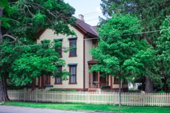 | Giles Gilbert House | building | 1987 | 87000137 |
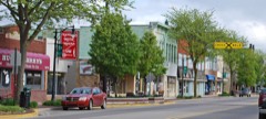 | Greenville Downtown Historic District | district | 2008 | 08001104 |
 | Winter Inn | building | 1980 | 80001883 |
Every wildfire the federal occurrence database records inside this county: 151 of them, burning about 638 acres. 24 started naturally and 10 were recorded as arson. Each settlement page carries the fires within five miles of it.
| Reported cause | Fires |
|---|---|
| Equipment and vehicle use | 62 |
| Missing data/not specified/undetermined | 35 |
| Natural | 24 |
| Debris and open burning | 11 |
| Arson/incendiarism | 10 |
| Recreation and ceremony | 7 |
| Fireworks | 1 |
| Smoking | 1 |
The five largest, by the area the report gives. Three of them were set deliberately.
| Date | Cause | Size | Reported by | Name on the report |
|---|---|---|---|---|
| 9 April 1994 | Debris and open burning | 100 acres | Michigan Department of Natural Resources | not named |
| 14 April 2003 | Arson/incendiarism | 52 acres | Michigan Department of Natural Resources | not named |
| 11 April 2006 | Arson/incendiarism | 43 acres | Michigan Department of Natural Resources | not named |
| 25 March 2019 | Natural | 40 acres | Michigan Department of Natural Resources | LAKEVIEW DISTRICT FD 0000057 - 2019 |
| 8 May 2006 | Recreation and ceremony | 28 acres | Michigan Department of Natural Resources | not named |
| 25 April 2019 | Natural | 25 acres | Michigan Department of Natural Resources | CARSON CITY FD 201920 - 2019 |
| 13 June 2018 | Equipment and vehicle use | 24 acres | Michigan Department of Natural Resources | MONTCALM 01 |
| 13 June 2018 | Arson/incendiarism | 23 acres | Michigan Department of Natural Resources | MONTCALM 02 |
Every settlement page carries the fires within five miles of it - see the settlement index below.
The NOAA Storm Events Database holds 212 reports for this county, causing no deaths, 34 injuries and about $21,573,500 in recorded property damage. Each settlement page carries the reports that name it.
| Kind of event | Reports |
|---|---|
| Thunderstorm Wind | 136 |
| Hail | 54 |
| Tornado | 11 |
| Flash Flood | 6 |
| Funnel Cloud | 2 |
| Flood | 2 |
| Lightning | 1 |
The most serious of them, by death, then injury, then recorded damage. The accounts are quoted exactly as the forecast office filed them.
| When | Event | Place named | Harm | What the report says |
|---|---|---|---|---|
| May 1998 | Thunderstorm Wind | Howard City | 23 hurt, $14,000,000 | Michigan State Police EMD's Damage and Injury Assessment Report indicated $453,000 in public damage costs, 23 injuries, 6 individuals being sheltered, 400 homes damaged, 30 homes destroyed, 40 businesses damaged, and 50 vacation residences either damaged or destroyed. Private property damage was estimated around $13.5 Million. Most severe damage was reported in Pierson and Maple Valley Townships in the western panhandle of the county, with several cottages destroyed and damaged near and around Cody Lake and other area lakes. Significant damage was also reported in and around the city of Stanton. A team from the Michigan National Guard was deployed to the city of Stanton to assist in debris removal and cleanup operations. Montcalm County declared a local state of emergency and was granted a Governor's disaster declaration to activate state assistance for the county. On June 24th, President Clinton granted a Major Disaster Declaration for Montcalm County, making federal disaster assistance available. |
| August 1973 | Tornado (F1) | not stated | 6 hurt, $25,000 | no account filed |
| July 2010 | Lightning | Vestaburg | 4 hurt | Four teenagers were struck by lightning near Vestaburg at a baseball diamond. There were no fatalities. |
| July 2003 | Hail | Greenville | 1 hurt, $20,000 | A motorcyclist suffered a minor injury when he was hit in the mouth by a hailstone. Three quarters inch hail was reported six miles north of Greenville and seven eighths inch diameter hail was reported five miles north of Greenville, where a parking lot was covered by hail near Colby and M-91. |
| April 2013 | Flood | Howard City | $3,000,000 | Heavy rain caused significant flooding on rivers and streams across Montcalm county. |
| April 2011 | Hail | Greenville Arpt | $1,000,000 | Trained spotters reported hail up to 1.5 inches in diameter south of Stanton and just north of Sheridan. The swath was up to one mile wide and was part of the swath that began in extreme northeast Ottawa County based on correlation with multiple spotter reports and radar hail products. |
| July 1994 | Tornado (F2) | Stanton | $500,000 | A brick, ranch style home in Fairplain Township was totally destroyed by an apparent tornado. No one actually saw a tornado, but the debris pattern and localization of the damage strongly suggested a tornado rather than straight-line thunderstorm winds. Seven people were in the home at the time, but no one was injured. A small shed was also torn up. The path length and width were estimated from the debris pattern. Trees up to 10 inches in diameter were broken off at the ground in a counter-clockwise pattern. |
| May 2020 | Flood | Langston | $250,000 | Multiple lakes flooded lakeside homes and multiple roads were flooded. |
| April 1965 | Tornado (F2) | not stated | $250,000 | no account filed |
| May 1956 | Tornado (F2) | not stated | $250,000 | no account filed |
| June 2023 | Thunderstorm Wind | Sidney | $200,000 | There were numerous reports of downed trees, limbs and power lines across Montcalm county. |
| August 2007 | Tornado (EF1) | Wyman | $150,000 | Surveys conducted by the NWS confirmed two main damage paths near the border of Home and Richland townships. These damage paths were located just north and south of Cutler road. ||The first damage path began about one mile west of the Cutler road and Vickeryville road intersection and extended northeast about one mile. The damge path was 100 to 200 yards wide. The vast majority of the damage was from straight line winds, but there was evidence of a very brief tornado touchdown in the damage path. ||Thousands of trees were uprooted or snapped off in the two damage paths. |This damage was consistent with EF-1 damage with maximum tornadic winds of 90 to 100 mph. |
| July 2001 | Thunderstorm Wind | Mc Brides | $150,000 | no account filed |
| July 2006 | Thunderstorm Wind | Entrican | $100,000 | Numerous trees were blown down and barn roofing was ripped off. |
| July 2006 | Thunderstorm Wind | Stanton | $100,000 | Trees and power lines were blown down in and near Stanton. |
| May 2004 | Thunderstorm Wind | Lakeview | $100,000 | Twenty to thirty trees were either damaged or blown down by severe thunderstorm wind gusts two miles west of Lakeview. |
| July 1995 | Thunderstorm Wind | Amble | $100,000 | About 100 trees of 18 to 24 inch diameter were blown over, houses and vehicles were damaged. One barn was destroyed. |
| May 2000 | Flash Flood | Countywide | $100,000 | no account filed |
| June 2023 | Thunderstorm Wind | Sheridan | $75,000 | Several trees and power lines were blown down across the county. |
| November 2020 | Thunderstorm Wind | Coral | $50,000 | Several power lines and trees were blown down. |
| July 2012 | Thunderstorm Wind | Howard City | $50,000 | Numerous reports of downed trees in and near Howard City and the northern portion of Montcalm county came in from Montcalm county dispatch. |
| May 1999 | Thunderstorm Wind | Lakeview | $50,000 | Thunderstorm winds blew down trees and power lines in Lakeview. |
| April 2001 | Thunderstorm Wind | Greenville | $50,000 | no account filed |
| May 2001 | Flash Flood | Countywide | $50,000 | no account filed |
| May 2001 | Flash Flood | Countywide | $50,000 | no account filed |
| August 2000 | Thunderstorm Wind | Stanton | $40,000 | no account filed |
| May 2012 | Thunderstorm Wind | Amsden | $30,000 | The broadcast media reported that peak winds estimated near 80 mph caused damage to a barn and unroofed an outbuilding two miles northwest of Fenwick. Several healthy trees were snapped or uprooted. |
| July 2006 | Thunderstorm Wind | Stanton | $30,000 | Numerous trees were blown down in Stanton and a roof was blown off of an old barn. |
| September 2021 | Thunderstorm Wind | Vestaburg | $25,000 | Multiple trees and power lines were blown down in Vestaburg. |
| October 2019 | Thunderstorm Wind | Howard City | $25,000 | An isolated severe storm produced high winds that blew several six to eight inch diameter trees down onto a barn near Howard City. Evergreen township was particularly hard hit with numerous trees down. Over seven thousand people in Montcalm county lost power. |
| September 2018 | Thunderstorm Wind | Sheridan | $25,000 | Several large trees were blown down and a few power outages were reported. |
| June 2008 | Thunderstorm Wind | Fenwick | $25,000 | Several large trees and limbs were blown down. Several power lines were also blown down and there was minor damage to a residence two miles south of Sheridan in Montcalm county. |
| July 2007 | Thunderstorm Wind | Westville | $25,000 | Several trees and limbs were blown down two to three miles northwest of Stanton. A tin roof was also ripped off of a barn by the wind gusts. |
| July 2005 | Thunderstorm Wind | Stanton | $25,000 | no account filed |
| May 2001 | Flash Flood | Countywide | $25,000 | no account filed |
| June 2000 | Thunderstorm Wind | Sheridan | $25,000 | no account filed |
| August 2000 | Thunderstorm Wind | Stanton | $25,000 | no account filed |
| August 1996 | Thunderstorm Wind | Sheridan | $25,000 | no account filed |
| July 1977 | Tornado (F1) | not stated | $25,000 | no account filed |
| April 1956 | Tornado (F5) | not stated | $25,000 | no account filed |
| November 2013 | Thunderstorm Wind | Greenville | $20,000 | A trained spotter reported several large branches were blown down and some damage to gutters and shingles of a restaurant. |
| July 2004 | Thunderstorm Wind | Gowen | $20,000 | Numerous trees were blown down in and near Gowen. |
| July 2003 | Hail | Greenville | $20,000 | Seven eighths inch diameter hail was reported approximately eight miles north of Greenville. |
| June 1999 | Thunderstorm Wind | Howard City | $20,000 | A tree and several power lines were downed by gusty thunderstorm winds near Howard City. Power lines were also downed near Amble, and marble sized hail was observed as well. |
| June 2005 | Hail | Greenville | $20,000 | no account filed |
| June 2000 | Thunderstorm Wind | Stanton | $20,000 | no account filed |
| August 1996 | Thunderstorm Wind | Sheridan | $20,000 | no account filed |
| June 2004 | Hail | Gowen | $15,000 | The broadcast media reported one and three quarters inch diameter hail in Gowen. |
| June 2004 | Hail | Vestaburg | $15,000 | Three quarters inch hail was reported by law enforcement four miles southwest of Vestaburg. |
| July 1999 | Thunderstorm Wind | Lakeview | $15,000 | A tree was downed and fell on a vehicle in Lakeview. |
| July 2023 | Thunderstorm Wind | Pierson | $10,000 | Several trees were blown down near Pierson. |
| August 2021 | Thunderstorm Wind | Howard City | $10,000 | A 74 mph wind gust was measured and there was a report of tree damage. |
| June 2020 | Thunderstorm Wind | Amble | $10,000 | Law enforcement reported downed trees and power outages across the county. |
| May 2019 | Thunderstorm Wind | Edmore | $10,000 | A trained spotter reported that several trees were blown down near the intersection of Wyman and Deaner roads. |
| September 2019 | Hail | Vestaburg | $10,000 | Hail up to one and a half inches in diameter was reported near Vestaburg. |
| July 2018 | Thunderstorm Wind | Howard City | $10,000 | Trained spotters reported that several trees were blown down. |
| April 2015 | Thunderstorm Wind | Lakeview | $10,000 | Montcalm county central dispatch reported that scattered trees were blown down across portions of Montcalm county. |
| September 2010 | Thunderstorm Wind | Gowen | $10,000 | The public reported that several trees were blown down three miles north of Greenville. |
| September 2007 | Thunderstorm Wind | Carson City | $10,000 | Numerous trees and power lines down by wind gusts estimated at 58 mph. |
| July 2006 | Hail | Carson City | $10,000 | Three quarters inch hail was reported in Carson City. |
The Survey's mineral resources record lists 11 workings inside this county. All of them still produce. Each settlement page carries the workings within five miles of it.
| Commodity | Workings |
|---|---|
| Sand and Gravel, Construction | 10 |
| REE | 1 |
The least common of them first, because a county's hundredth gravel pit says nothing its first ten did not.
| Where | Site | Commodity | Status | Recorded |
|---|---|---|---|---|
| Hitachi Magnetics Corp--Edmore, Mi. | REE | Producer | ||
| Anderson Pit | Sand and Gravel, Construction | Producer | ||
| Dyer Co. Pit | Sand and Gravel, Construction | Producer | ||
| Dyer Co. Pit | Sand and Gravel, Construction | Producer | ||
| Dyer Co. Pit | Sand and Gravel, Construction | Producer | ||
| Harris Pit | Sand and Gravel, Construction | Producer | ||
| Montcalm County Road Comm. Pit | Sand and Gravel, Construction | Producer | ||
| Montcalm County Road Comm. Pit | Sand and Gravel, Construction | Producer | ||
| Shook Pit | Sand and Gravel, Construction | Producer | ||
| Wheeler Pit | Sand and Gravel, Construction | Producer | ||
| Wheeler Sand and Gravel Pit | Sand and Gravel, Construction | Producer |
Named settlements recorded in the Geographic Names Information System, each with the topographic sheets covering it. Villages, hamlets and abandoned places alike. Each is shown with the nearest named watercourse or landform and the survey quadrangle it falls on.
Carson City city · 48811 · On Butternut Creek · Carson City quadrangle
10 sheets, 1954 to 1985
Belvidere township · 48886 · On Townline Creek · Six Lakes quadrangle
11 sheets, 1954 to 1986