 Block
From the record
14 National Register listings published here, 1 of them a National Historic Landmark.
Sources: the National Register database, National Park Service
57 topographic sheets cover 32 settlements here, and 14 properties are on the National Register of Historic Places.
14 National Register listings published here, 1 of them a National Historic Landmark.
Sources: the National Register database, National Park Service
Every property in this county listed on the National Register of Historic Places, with the year it was listed and the federal nomination document.
| Photograph | Property | Type | Listed | Reference |
|---|---|---|---|---|
 | Amazon Hosiery Mill | building | 1982 | 82002857 |
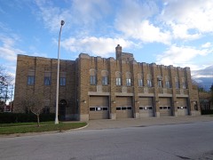 | Central Fire Station | building | 1999 | 99000341 |
 | Charles H. Hackley House | building | 1970 | 70000282 |
 | Horatio N. Hovey House | building | 1983 | 83000887 |
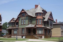 | Hume House | building | 1972 | 72000646 |
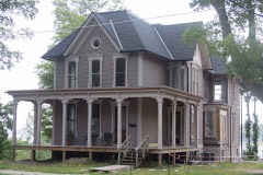 | Lewis, John C. and Augusta (Covell), House | building | 2010 | 10001027 |
| C.W. Marsh Company Building | building | 2025 | 100012321 | |
 | Muskegon Historic District | district | 1972 | 72000647 |
 | Muskegon South Breakwater Light | structure | 2006 | 06001026 |
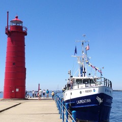 | Muskegon South Pierhead Light | structure | 2006 | 06000036 |
 | Muskegon YMCA Building | building | 1982 | 82002858 |
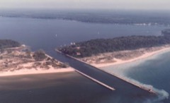 | Navigation Structures at White Lake Harbor | structure | 2000 | 00000535 |
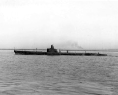 | U.S.S. SILVERSIDES | structure | 1972 | 72000453 |
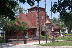 | Union Depot | building | 2000 | 00001489 |
Every wildfire the federal occurrence database records inside this county: 288 of them, burning about 1,678 acres. 9 started naturally and 34 were recorded as arson. Each settlement page carries the fires within five miles of it.
| Reported cause | Fires |
|---|---|
| Missing data/not specified/undetermined | 79 |
| Equipment and vehicle use | 76 |
| Debris and open burning | 36 |
| Arson/incendiarism | 34 |
| Recreation and ceremony | 27 |
| Misuse of fire by a minor | 15 |
| Natural | 9 |
| Smoking | 6 |
| Railroad operations and maintenance | 3 |
| Power generation/transmission/distribution | 2 |
| Other causes | 1 |
The five largest, by the area the report gives. Three of them were set deliberately.
| Date | Cause | Size | Reported by | Name on the report |
|---|---|---|---|---|
| 14 April 2003 | Arson/incendiarism | 276 acres | Michigan Department of Natural Resources | MUSKEGON |
| 2 April 2010 | Power generation/transmission/distribution | 175 acres | Michigan Department of Natural Resources | MUSKEGON 05 |
| 8 May 1994 | Arson/incendiarism | 152 acres | Michigan Department of Natural Resources | not named |
| 10 April 1996 | Arson/incendiarism | 60 acres | Michigan Department of Natural Resources | not named |
| 1 May 1992 | Debris and open burning | 49 acres | Michigan Department of Natural Resources | not named |
| 20 July 2013 | Power generation/transmission/distribution | 44 acres | Michigan Department of Natural Resources | MUSKEGON 03 |
| 20 May 2016 | Debris and open burning | 43 acres | Michigan Department of Natural Resources | not named |
| 21 April 2007 | Debris and open burning | 32 acres | Michigan Department of Natural Resources | not named |
Every settlement page carries the fires within five miles of it - see the settlement index below.
The NOAA Storm Events Database holds 240 reports for this county, causing no deaths, 5 injuries and about $43,170,200 in recorded property damage. Each settlement page carries the reports that name it.
| Kind of event | Reports |
|---|---|
| Thunderstorm Wind | 150 |
| Hail | 66 |
| Flash Flood | 9 |
| Tornado | 8 |
| Flood | 2 |
| Seiche | 1 |
| Waterspout | 1 |
| Lightning | 1 |
| Heavy Rain | 1 |
| Funnel Cloud | 1 |
The most serious of them, by death, then injury, then recorded damage. The accounts are quoted exactly as the forecast office filed them.
| When | Event | Place named | Harm | What the report says |
|---|---|---|---|---|
| May 1998 | Thunderstorm Wind | Montague | 2 hurt, $24,210,000 | Michigan State Police EMD Damage and Injury Assessment Report indicated $2,458,958 in public damage costs, 42 homes destroyed, 1805 homes damaged, 5 businesses destroyed, and 73 businesses damaged. Two injuries were reported. Total public and private costs have been estimated at $24,205,908 according to FEMA and local media reports. Numerous local roads were closed during the day of May 31st for tree and debris removal. Approximately 50% of the city of Whitehall was left without water service and 50,000 customers were left without power in Muskegon County. The Muskegon Chronicle reported 5 large transmission towers were toppled northeast of the city of Muskegon. These towers carried high voltage electricity and were designed to withstand sustained 90 mph winds and gusts to 110 mph. The Muskegon Chronicle also reported severe crop damage to fruit trees (including apple, cherry, and peach) in the southeast part of Muskegon County. Estimated crop damage was $5.0 Million. Severe tree damage was reported in Muskegon State Park, Hoffmaster State Park, and Duck Lake State Park, all bordering Lake Michigan. Muskegon County declared a local state of emergency and was granted a Governor's disaster declaration to activate state assistance for the county. On June 24th, President Clinton granted a Major Disaster Declaration for Muskegon County, making federal disaster assistance available. |
| August 2002 | Thunderstorm Wind | Norton Shrs | 2 hurt, $10,000 | An isolated severe thunderstorm blew down a tree in Norton Shores. The tree fell down on and injured two people who were taking a walk through woods near Lake Michigan. Law enforcement in Fruitport reported that several tree limbs and power lines were blown down. |
| June 2008 | Thunderstorm Wind | Michillinda | 1 hurt | A sixteen inch diameter branch fell on a truck and resulted in minor injuries. |
| May 2020 | Flood | Montague Arpt | $6,000,000 | Many roads across Muskegon county were flooded and there were also numerous reports of flooded basements. 67 homes sustained major damage and 3 homes incurred minor damage. |
| April 2013 | Flood | Whitehall | $5,000,000 | Heavy rain caused significant flooding on rivers and streams across Muskegon county. |
| August 2009 | Thunderstorm Wind | Muskegon | $2,000,000 | A peak wind gust of 61 mph was recorded at the Muskegon airport. Wind gusts of at least 75 mph were estimated based on damage across far southern Muskegon county in the Fruitport area, where hundreds of trees and numerous power lines were blown down. The entire village was left without power. |
| April 2014 | Thunderstorm Wind | Muskegon Hgts | $1,000,000 | Numerous trees were blown down in and near Muskegon. Numerous windows were blown out of area homes and businesses. 30,000 people in and near Muskegon lost power. Wind gusts with severe storms were estimated at up to 85 mph. A 60 mph wind gust was measured at the Muskegon airport. |
| May 1998 | Thunderstorm Wind | Muskegon | $1,000,000 | Widespread wind damage occurred in the Muskegon metropolitan area including the cities of Muskegon, North Muskegon, Muskegon Heights, and Norton Shores and Laketon, Muskegon, and Fruitport Townships. Many large trees, utility poles, and power lines were downed by sustained 60 to 80 mph winds (estimated) over a 10 to 15 minute period. Overall, an estimated 900 power lines were downed in the Muskegon area which left approximately 54,000 homes and businesses without power, affecting approximately a third of all Muskegon County residents. Most structural damage to homes and businesses was caused by fallen trees and utility poles. An estimated 500 homes and 30 businesses sustained minor to moderate damage. Most area schools and many area businesses were closed on Friday, May 29th. An estimated 27,000 people were still without power as of late in the day, Saturday, May 30th. Despite the widespread damage, no injuries were reported. |
| April 2020 | Hail | Whitehall | $500,000 | Hail up to one and three quarters inches in diameter was reported near Whitehall. |
| May 2001 | Flash Flood | Muskegon | $500,000 | no account filed |
| June 2024 | Thunderstorm Wind | Whitehall | $250,000 | Wind gusts to near 70 mph downed numerous trees and power lines and caused considerable damage. |
| June 2024 | Thunderstorm Wind | (Mkg)Muskegon Arpt | $250,000 | A peak wind gust to 71 mph was recorded at the Muskegon airport ASOS. Numerous trees and power lines were blown down. |
| November 2013 | Thunderstorm Wind | Muskegon Lake | $200,000 | A severe thunderstorm produced a measured wind gust of 62 mph at the Muskegon GLERL site. There were several reports of downed trees and power lines across Muskegon county. In Canada Corners, seven light poles were blown down and several large trees were snapped or uprooted at Moss Ridge golf course. |
| August 2000 | Thunderstorm Wind | Muskegon | $150,000 | no account filed |
| August 2009 | Thunderstorm Wind | Norton Shrs | $100,000 | Hundreds of trees were blown down in Fruitport. Approximately one dozen homes were heavily damaged by falling trees. Extensive damage to utilities was reported with numerous lines and poles snapped in Fruitport. Scattered trees were blown down over the far southern part of the county from the Lake Michigan coastline to the Kent county border. |
| February 2001 | Flash Flood | Countywide | $100,000 | no account filed |
| May 2000 | Flash Flood | Countywide | $100,000 | no account filed |
| September 2021 | Thunderstorm Wind | Muskegon | $50,000 | Severe storms resulted in several reports of wind damage. |
| November 2020 | Thunderstorm Wind | Fruitport | $50,000 | Multiple trees were blown down across eastern Muskegon county. |
| July 2019 | Thunderstorm Wind | (Mkg)Muskegon Arpt | $50,000 | A 56 knot gust was recorded at the Muskegon county airport. |
| June 2016 | Thunderstorm Wind | Norton Shrs | $50,000 | A 63 mph wind gust was measured at the Muskegon ASOS station and there were several reports of trees blown down in and near Muskegon. Several trees were blown down in Muskegon state park as well as east of the park and near Cloverville. |
| June 2014 | Thunderstorm Wind | Whitehall | $50,000 | The media reported that a large tree fell on a house and that multiple trees were blown down in Whitehall. |
| November 2013 | Tornado (EF0) | Trent | $50,000 | A severe thunderstorm produced multiple brief EF-0 tornadoes along a more than 50 mile path from Muskegon county northeast through Newaygo county into Mecosta county. The tornadoes were on the ground for very short periods of time. Mostly tree damage was incurred but there was also damage to several buildings and fences. |
| September 2010 | Thunderstorm Wind | Michillinda | $50,000 | An NWS storm survey revealed only spotty tree damage near Duck Lake state park and Muskegon. A 76 mph wind gust was measured at the Muskegon GLERL field station. |
| April 1994 | Thunderstorm Wind | not stated | $50,000 | Winds were measured at 50 knots at Muskegon County Airport. A portion of the roof of a movie theater was torn off. The theater was evacuated, and no one was injured. Menominee County Menominee,24,1543EST,,,0,0,0,0,Hail (1.0) |
| April 2001 | Hail | Fruitport | $50,000 | no account filed |
| May 2000 | Hail | Twin Lake | $50,000 | no account filed |
| May 2000 | Thunderstorm Wind | Muskegon | $50,000 | no account filed |
| July 2020 | Thunderstorm Wind | Muskegon | $40,000 | Several trees were blown down near the intersection of Merrill Avenue and Fourth Street which also damaged several homes in that area. |
| July 1998 | Lightning | Muskegon | $40,000 | The Muskegon Chronicle reported lightning strikes caused 2 separate fires in the area and resulted in power outages affecting 7,500 people in the Muskegon service area. A house fire at 2862 Evanston Avenue in Muskegon Township was caused by a lightning strike. The fire burned the attic and damage was estimated at $40,000. Lightning was also the cause of a fire at an 18-unit storage building at Boxer Store and Lock in Egelston Township. The sheet metal and wood frame building and all of its contents were completely destroyed. A damage estimate for this fire was not available. |
| June 2000 | Thunderstorm Wind | Muskegon | $40,000 | no account filed |
| May 2004 | Thunderstorm Wind | Cloverville | $30,000 | Numerous large tree limbs were blown down in Cloverville and Norton Shores. |
| July 2005 | Thunderstorm Wind | Fruitport | $30,000 | no account filed |
| August 2019 | Hail | Twin Lake | $25,000 | A public report of hail up to one and three quarters inches in diamter was received from near Twin Lake. |
| April 2015 | Thunderstorm Wind | Muskegon | $25,000 | An outbuilding was blown down near the LC Walker arena along with some downed power lines in Muskegon. |
| August 2015 | Thunderstorm Wind | North Muskegon | $25,000 | Several large trees were blown down across portions of Muskegon county. |
| August 2007 | Thunderstorm Wind | Dalton | $25,000 | Fully grown oak trees were blown down on some houses in Fruitland and Dalton townships. Some trees were reported to be eighteen inches in diameter. Measured 63 mph wind gusts were recorded at the Muskegon GLERL site and in Norton Shores. |
| August 2004 | Thunderstorm Wind | Whitehall | $25,000 | A tree was blown down onto a mobile home and numerous tree limbs and power lines were blown down in Whitehall. |
| July 2003 | Hail | Muskegon | $25,000 | Three quarters inch hail was reported in Muskegon. |
| August 2003 | Hail | Muskegon | $25,000 | One and three quarters inch diameter hail was reported in Muskegon township, and three quarters inch diameter hail was reported in Lakewood Club. |
| October 2006 | Thunderstorm Wind | Norton Shrs | $25,000 | no account filed |
| May 2001 | Flash Flood | Countywide | $25,000 | no account filed |
| May 2001 | Thunderstorm Wind | Muskegon | $25,000 | no account filed |
| May 2001 | Hail | Countywide | $25,000 | no account filed |
| May 2001 | Hail | Whitehall | $25,000 | no account filed |
| May 2001 | Flash Flood | Countywide | $25,000 | no account filed |
| May 2001 | Hail | Countywide | $25,000 | no account filed |
| May 2001 | Flash Flood | Countywide | $25,000 | no account filed |
| August 2000 | Thunderstorm Wind | Ravenna | $25,000 | no account filed |
| September 1965 | Tornado (F2) | not stated | $25,000 | no account filed |
| July 2023 | Thunderstorm Wind | Trent | $20,000 | An emergency manager reported that an isolated severe storm blew down several old barns. |
| June 2007 | Thunderstorm Wind | Norton Shrs | $20,000 | Numerous trees and power lines were blown down in Norton Shores. |
| October 2002 | Thunderstorm Wind | Roosevelt Park | $20,000 | Numerous trees were blown down near the intersection of Roosevelt and Summit streets by thunderstorm wind gusts, as reported by local law enforcement. |
| May 1998 | Seiche | Wabaningo | $20,000 | The tug boat Stephen M. Asher sunk in White Lake Channel, just north of Wabaningo between Lake Michigan and White Lake, at approximately 5:15 am EDT due to a seiche created by the derecho moving across Lake Michigan. The crew reported a storm surge swept through the channel into White Lake as the derecho moved onshore. As the storm passed, the water rushed back out of White Lake through the channel, reaching the top of the channel walls. The tug boat, floating against a barge, rolled on its side and sank. No crew members were injured. The company which owns the tug boat estimated repairs would cost $20,000. |
| May 1998 | Thunderstorm Wind | Fruitport | $20,000 | Several trees and power lines downed in Fruitport. Airline Road area was especially hard-hit. |
| June 2020 | Thunderstorm Wind | Ravenna | $15,000 | Several trees were blown down across southern Muskegon county. |
| August 2018 | Thunderstorm Wind | Muskegon Lake | $15,000 | Several trees and power lines were blown down across portions of Muskegon county. |
| August 2015 | Thunderstorm Wind | Slocum | $15,000 | An amateur radio operator reported multiple trees and power lines were blown down at the Crockey Creek campground. |
| July 2006 | Thunderstorm Wind | Montague | $15,000 | Several large trees were blown down in Montague. |
| May 2004 | Hail | Lakewood Club | $15,000 | Law enforcement one mile south of Lakewood Club reported three quarters inch diameter hail. |
The Survey's mineral resources record lists 11 workings inside this county. 5 still produce and 6 are closed or unrecorded. Each settlement page carries the workings within five miles of it.
| Commodity | Workings |
|---|---|
| Silica | 4 |
| Sand and Gravel, Construction | 3 |
| Fire Clay (Refractory) | 2 |
| Titanium | 1 |
| Titanium, Metal | 1 |
The least common of them first, because a county's hundredth gravel pit says nothing its first ten did not.
| Where | Site | Commodity | Status | Recorded |
|---|---|---|---|---|
| Howmet Corp--Whitehall, Mich. | Titanium | Past Producer | ||
| Whitehall Plant Ti | Titanium, Metal | Plant | 1992 | |
| Muskegon Brick Co Clay Pit | Fire Clay (Refractory) | Past Producer | ||
| Whitehall Clay Pit | Fire Clay (Refractory) | Past Producer | ||
| Miller Pit | Sand and Gravel, Construction | Past Producer | ||
| Whitehall Pit | Sand and Gravel, Construction | Producer | ||
| Yerington Construction Co. Pit | Sand and Gravel, Construction | Past Producer | ||
| Lincoln Avenue Site | Silica | Producer | Sedimentary | |
| Mccormick Pit | Silica | Past Producer | ||
| Nugent Pit | Silica | Producer | ||
| Sherman Boulevard Site | Silica | Producer | Sedimentary |
Named settlements recorded in the Geographic Names Information System, each with the topographic sheets covering it. Villages, hamlets and abandoned places alike. Each is shown with the nearest named watercourse or landform and the survey quadrangle it falls on.
Fruitport Charter Township · 49415 · On Willow Hill Creek · Muskegon East quadrangle
11 sheets, 1930 to 1982
Muskegon city · 49440 · On Ryerson Creek · Muskegon East quadrangle
11 sheets, 1930 to 1982
Muskegon Heights city · 49444 · On Little Black Creek · Muskegon East quadrangle
11 sheets, 1930 to 1982
North Muskegon city · 49445 · On Bear Creek · Dalton quadrangle
10 sheets, 1929 to 1983
Norton Shores city · 49441 · On Little Black Creek · Muskegon West quadrangle
11 sheets, 1930 to 1982
Ravenna township · 49451 · On North Branch Crockery Creek · Ravenna quadrangle
13 sheets, 1945 to 1986
Whitehall city · 49461 · On Bush Creek · Montague quadrangle
10 sheets, 1929 to 1983