 Block
From the record
3 National Register listings published here.
Sources: the National Register database, National Park Service
67 topographic sheets cover 38 settlements here, and 3 properties are on the National Register of Historic Places.
3 National Register listings published here.
Sources: the National Register database, National Park Service
Every property in this county listed on the National Register of Historic Places, with the year it was listed and the federal nomination document.
| Photograph | Property | Type | Listed | Reference |
|---|---|---|---|---|
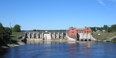 | Croton Hydroelectric Plant | structure | 1979 | 79001165 |
 | Fremont High School | building | 2013 | 13000669 |
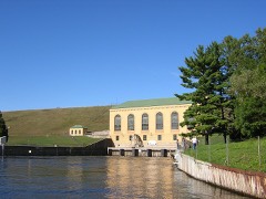 | Hardy Hydroelectric Plant | structure | 1997 | 97001479 |
Every wildfire the federal occurrence database records inside this county: 905 of them, burning about 2,578 acres. 23 started naturally and 36 were recorded as arson. Each settlement page carries the fires within five miles of it.
| Reported cause | Fires |
|---|---|
| Debris and open burning | 392 |
| Missing data/not specified/undetermined | 158 |
| Equipment and vehicle use | 92 |
| Recreation and ceremony | 77 |
| Power generation/transmission/distribution | 44 |
| Arson/incendiarism | 36 |
| Smoking | 30 |
| Misuse of fire by a minor | 30 |
| Natural | 23 |
| Other causes | 10 |
| Fireworks | 10 |
| Railroad operations and maintenance | 3 |
The five largest, by the area the report gives. Three of them were set deliberately.
| Date | Cause | Size | Reported by | Name on the report |
|---|---|---|---|---|
| 14 April 2003 | Debris and open burning | 162 acres | Huron-Manistee National Forest | BILLS LAKE |
| 23 April 1994 | Recreation and ceremony | 107 acres | Michigan Department of Natural Resources | not named |
| 1 May 2018 | Arson/incendiarism | 105 acres | Huron-Manistee National Forest | OAK |
| 5 July 2018 | Arson/incendiarism | 105 acres | Michigan Department of Natural Resources | NEWAYGO 04 |
| 23 April 1994 | Missing data/not specified/undetermined | 80 acres | Huron-Manistee National Forest | OTTERMAN |
| 27 April 2003 | Debris and open burning | 80 acres | Huron-Manistee National Forest | 16 MILE |
| 22 April 1994 | Debris and open burning | 60 acres | Huron-Manistee National Forest | TROY |
| 1 April 1997 | Arson/incendiarism | 58 acres | Huron-Manistee National Forest | FIRST |
Every settlement page carries the fires within five miles of it - see the settlement index below.
The NOAA Storm Events Database holds 179 reports for this county, causing 4 deaths, 3 injuries and about $14,738,750 in recorded property damage. Each settlement page carries the reports that name it.
| Kind of event | Reports |
|---|---|
| Thunderstorm Wind | 98 |
| Hail | 54 |
| Tornado | 14 |
| Flash Flood | 7 |
| Flood | 5 |
| Lightning | 1 |
The most serious of them, by death, then injury, then recorded damage. The accounts are quoted exactly as the forecast office filed them.
| When | Event | Place named | Harm | What the report says |
|---|---|---|---|---|
| July 2012 | Thunderstorm Wind | Newaygo | 2 killed | Large Tree Fell on a House. Several Other Large Trees nearby were blow over. |
| September 1951 | Tornado (F2) | not stated | 1 killed, 3 hurt | no account filed |
| June 1975 | Tornado (F2) | not stated | 1 killed | no account filed |
| April 2013 | Flood | Volney | $5,000,000 | Heavy rain caused significant flooding on rivers and streams across Newaygo county. |
| April 2014 | Flood | Croton | $4,000,000 | Four hundred and three homes were impacted by flooding along the Muskegon River as a result of melting of a significant snow cover and significant rainfall on April 12. Significant damage was also incurred to area roads. Governor Synyder declared Newaygo county to be in a state of disaster. |
| March 2019 | Flood | Newaygo | $1,700,000 | The combination of rain and snowmelt resulted in flooding and closure of more than a hundred roads. 30 roads were completely washed out. |
| May 1998 | Thunderstorm Wind | Woodland Park | $1,240,000 | Michigan State Police EMD's Damage and Injury Assessment Report indicated $1,237,000 in public damage costs, 48 homes destroyed, 690 homes damaged, and 15 businesses damaged across Newaygo County. Damage estimates for private property were not available. Newaygo County declared a local state of emergency and was granted a Governor's disaster declaration to activate state assistance for the county. On June 24th, President Clinton granted a Major Disaster Declaration for Newaygo County, making federal disaster assistance available. |
| April 2014 | Thunderstorm Wind | Grant | $200,000 | Roofs were blown off multiple structures and campers were blown over. Several trees were blown down across southern Newaygo county. |
| June 2023 | Thunderstorm Wind | Ashland Center | $150,000 | A 911 call center reported that numerous trees and power lines were blown down across the county. |
| June 2023 | Thunderstorm Wind | White Cloud | $100,000 | Multiple trees and limbs were blown down near White Cloud. |
| August 2011 | Flash Flood | Hesperia | $100,000 | Significant flooding occurred across the southern half of Newaygo county and campers in Henning Park just east northeast of Newaygo had to be evacuated. These campers were part of the Newaygo National Kayak and Canoeing Championships. Several roads in the county were closed due to flash flooding. |
| June 2008 | Lightning | Ensley Center | $100,000 | A lightning strike resulted in a gas well fire in Ensley Center. |
| July 2006 | Thunderstorm Wind | Newaygo | $100,000 | Many trees were blown down in and around Newaygo county. |
| February 2001 | Flash Flood | Countywide | $100,000 | no account filed |
| April 2001 | Thunderstorm Wind | White Cloud | $100,000 | no account filed |
| May 2012 | Thunderstorm Wind | Hesperia | $75,000 | The Newaygo county road commission and amateur radio operators reported 20 to 25 trees of varying health and size were blown down one mile north northwest of Fremont. Stone Road near 30th street had trees down and multiple trees were also blown down at Stone Road between 32nd and 34th streets. |
| May 2024 | Thunderstorm Wind | Wooster | $50,000 | Trees and power lines were blown down north of Fremont. |
| July 2019 | Thunderstorm Wind | Croton | $50,000 | Trees were blown down county wide and Croton was especially hard hit. |
| August 2018 | Thunderstorm Wind | Brohman | $50,000 | A NWS storm survey confirmed areas of tree damage consistent with winds up to 75 mph southeast of Brohman along 6 mile road near Evergreen Drive extending to Spruce Avenue. |
| August 2018 | Thunderstorm Wind | Woodville | $50,000 | Numerous trees were blown down across portions of Newaygo county. |
| July 2015 | Thunderstorm Wind | Woodville | $50,000 | The Newaygo county road commission reported that around 50 large trees were blown down across mainly the northern half of Newaygo county. |
| November 2013 | Tornado (EF0) | Grant | $50,000 | A severe thunderstorm produced multiple brief EF-0 tornadoes along a more than 50 mile path from Muskegon county northeast through Newaygo county into Mecosta county. The tornadoes were on the ground for very short periods of time. Mostly tree damage was incurred but there was also damage to several buildings and fences. |
| July 2012 | Thunderstorm Wind | White Cloud | $50,000 | Numerous reports of trees and power lines down in White Cloud and Newaygo. |
| July 1994 | Thunderstorm Wind | Fremont | $50,000 | Numerous trees and power lines were reported down throughout the county. Minor structural damage was also observed. |
| April 2001 | Thunderstorm Wind | Newaygo | $50,000 | no account filed |
| May 2001 | Flash Flood | Countywide | $50,000 | no account filed |
| May 2001 | Flash Flood | Countywide | $50,000 | no account filed |
| November 2020 | Thunderstorm Wind | Grant Arpt | $40,000 | Several trees and power lines were blown down across parts of Newaygo county. |
| May 2000 | Hail | Brunswick | $40,000 | no account filed |
| October 2006 | Thunderstorm Wind | Woodland Park | $30,000 | no account filed |
| May 2000 | Hail | Newaygo | $30,000 | no account filed |
| June 2024 | Thunderstorm Wind | Hesperia | $25,000 | Several trees were blown down near Hesperia. |
| August 2022 | Thunderstorm Wind | Big Prairie | $25,000 | Several trees were blown down across Newaygo county. |
| October 2021 | Thunderstorm Wind | Oxpow | $25,000 | Newaygo central dispatch reported that a tree was blown down and fell onto a home just north of Croton. |
| May 2020 | Flood | Sitka | $25,000 | A couple of roads were closed in Bridgeton due to water over roads. |
| October 2019 | Flood | Sitka | $25,000 | The Newaygo county emergency manager reported several road closures. Luce avenue between 24th and 32nd was closed, and Van Buren avenue was closed east of North Spruce all due to water over the roads. 112th street was also closed between Dickinson and Fitzgerald avenues due to water over the road. |
| July 2012 | Thunderstorm Wind | Hesperia | $25,000 | About a hundred trees were blown down northeast of a line from Hesperia to Newaygo. |
| July 2012 | Thunderstorm Wind | Hesperia | $25,000 | There were numerous reports of trees blown down in and near Hesperia. |
| July 2003 | Hail | White Cloud | $25,000 | Three quarters inch diameter hail was reported six miles southeast of White Cloud, and hail briefly covered the ground there. |
| July 2003 | Thunderstorm Wind | Newaygo | $25,000 | Numerous reports of blown down trees and power lines were received from Newaygo. |
| October 2002 | Thunderstorm Wind | Countywide | $25,000 | Law enforcement in Newaygo county reported that many trees were blown down across all of the county. |
| July 2005 | Thunderstorm Wind | Fremont | $25,000 | no account filed |
| May 2001 | Flash Flood | Countywide | $25,000 | no account filed |
| May 2001 | Flash Flood | Countywide | $25,000 | no account filed |
| June 2000 | Thunderstorm Wind | Newaygo | $25,000 | no account filed |
| July 2000 | Thunderstorm Wind | Bitely | $25,000 | no account filed |
| August 2000 | Thunderstorm Wind | Fremont | $25,000 | no account filed |
| June 1990 | Tornado (F1) | not stated | $25,000 | no account filed |
| September 1990 | Tornado (F1) | not stated | $25,000 | no account filed |
| May 1989 | Tornado (F1) | not stated | $25,000 | no account filed |
| April 1979 | Tornado (F1) | not stated | $25,000 | no account filed |
| April 1964 | Tornado (F1) | not stated | $25,000 | no account filed |
| May 2004 | Hail | Hesperia | $20,000 | Seven eighths inch diameter hail was reported by law enforcement in Hesperia. |
| May 2004 | Hail | Newaygo | $20,000 | One inch diameter was reported in Newaygo by an emergency manager. |
| May 2004 | Hail | Newaygo | $20,000 | Three quarters to seven eighths inch diameter hail was reported by law enforcement and the public from around ten miles east of Newaygo to Fremont. |
| May 2004 | Thunderstorm Wind | White Cloud | $20,000 | Several trees were blown down five miles west of White Cloud. |
| June 2020 | Thunderstorm Wind | Croton | $15,000 | Several trees were blown down. |
| September 2006 | Hail | Fremont | $15,000 | Three quarters inch diameter hail was reported by the public four miles west of Fremont. |
| May 2004 | Hail | Brohman | $15,000 | Law enforcement in Brohman reported three quarters inch diameter hail. |
| July 2003 | Thunderstorm Wind | White Cloud | $15,000 | Several six inch tree limbs were blown down in White Cloud. A two foot diameter tree was also blown down brought several power lines down with it when it fell. |
The Survey's mineral resources record lists 14 workings inside this county. 10 still produce and 4 are closed or unrecorded. Each settlement page carries the workings within five miles of it.
| Commodity | Workings |
|---|---|
| Sand and Gravel, Construction | 12 |
| Clay | 1 |
| Fire Clay (Refractory) | 1 |
The least common of them first, because a county's hundredth gravel pit says nothing its first ten did not.
| Where | Site | Commodity | Status | Recorded |
|---|---|---|---|---|
| Grant Tile Co Clay Pit | Fire Clay (Refractory) | Past Producer | ||
| Ne Newaygon Clay Pit | Clay | Prospect | ||
| Burkett Pit | Sand and Gravel, Construction | Producer | ||
| Cousineau Gravel, Inc. Pit | Sand and Gravel, Construction | Producer | ||
| Cousineau Gravel, Inc. Pit | Sand and Gravel, Construction | Producer | ||
| Cousineau Gravel, Inc. Pit | Sand and Gravel, Construction | Producer | ||
| Howard Eichenberg Company | Sand and Gravel, Construction | Producer | ||
| K & V Gravel Co. Pit | Sand and Gravel, Construction | Producer | ||
| K & V Pit | Sand and Gravel, Construction | Producer | ||
| Leroy Pit | Sand and Gravel, Construction | Producer | ||
| Newaygo County Road Comm. Pit | Sand and Gravel, Construction | Producer | ||
| Rose Pit | Sand and Gravel, Construction | Producer | ||
| Yerington Construction Co. Pit | Sand and Gravel, Construction | Past Producer | ||
| Yerington Construction Co. Pit | Sand and Gravel, Construction | Past Producer |
Named settlements recorded in the Geographic Names Information System, each with the topographic sheets covering it. Villages, hamlets and abandoned places alike. Each is shown with the nearest named watercourse or landform and the survey quadrangle it falls on.
Everett township · 49349 · White Cloud quadrangle
14 sheets, 1954 to 1991
No longer a settlement
Big Prairie township · 49349 · On South Mitchell Creek · Big Bend quadrangle
13 sheets, 1954 to 1991
Croton township · 49337 · On Little Muskegon River · Croton quadrangle
12 sheets, 1954 to 1986
Sherman township · 49349 · On Coonskin Creek · White Cloud quadrangle
14 sheets, 1954 to 1991
Big Prairie township · 49337 · On Linn Creek · Big Bend quadrangle
13 sheets, 1954 to 1991
Croton township · 49337 · On Little Muskegon River · Croton quadrangle
12 sheets, 1954 to 1986
White Cloud city · 49349 · On Flinton Creek · White Cloud quadrangle
14 sheets, 1954 to 1991
The vanished settlements of Newaygo County: the places named above that are no longer on the map.