 Block
From the record
1 National Register listing published here.
Sources: the National Register database, National Park Service
27 topographic sheets cover 8 settlements here, and 1 property is on the National Register of Historic Places.
1 National Register listing published here.
Sources: the National Register database, National Park Service
Every property in this county listed on the National Register of Historic Places, with the year it was listed and the federal nomination document.
| Photograph | Property | Type | Listed | Reference |
|---|---|---|---|---|
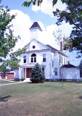 | Oscoda County Courthouse | building | 1972 | 72000651 |
Every wildfire the federal occurrence database records inside this county: 382 of them, burning about 16,057 acres. 11 started naturally and 41 were recorded as arson. Each settlement page carries the fires within five miles of it.
| Reported cause | Fires |
|---|---|
| Debris and open burning | 87 |
| Missing data/not specified/undetermined | 70 |
| Recreation and ceremony | 52 |
| Power generation/transmission/distribution | 47 |
| Arson/incendiarism | 41 |
| Equipment and vehicle use | 39 |
| Natural | 11 |
| Misuse of fire by a minor | 11 |
| Smoking | 9 |
| Other causes | 8 |
| Fireworks | 6 |
| Railroad operations and maintenance | 1 |
The five largest, by the area the report gives. None of them was recorded as arson.
| Date | Cause | Size | Reported by | Name on the report |
|---|---|---|---|---|
| 30 April 2006 | Debris and open burning | 5,818 acres | Huron-Manistee National Forest | HUGHES LAKE FIRE |
| 30 April 2000 | Recreation and ceremony | 5,200 acres | Huron-Manistee National Forest | NO PABLO |
| 1 May 1999 | Equipment and vehicle use | 1,035 acres | Huron-Manistee National Forest | HURON COMPLEX |
| 1 May 1999 | Equipment and vehicle use | 840 acres | Huron-Manistee National Forest | ATV |
| 25 April 2012 | Missing data/not specified/undetermined | 820 acres | Huron-Manistee National Forest | LITTLE MACK LAKE |
| 17 June 1992 | Natural | 687 acres | Huron-Manistee National Forest | LUZERNE |
| 29 April 2004 | Power generation/transmission/distribution | 448 acres | Huron-Manistee National Forest | KINSEY HUNT |
| 30 October 1999 | Recreation and ceremony | 97 acres | Huron-Manistee National Forest | WAGNER LAKE |
Every settlement page carries the fires within five miles of it - see the settlement index below.
The NOAA Storm Events Database holds 113 reports for this county, causing 2 deaths, 4 injuries and about $3,201,250 in recorded property damage. Each settlement page carries the reports that name it.
| Kind of event | Reports |
|---|---|
| Thunderstorm Wind | 51 |
| Hail | 51 |
| Tornado | 7 |
| Flash Flood | 2 |
| Lightning | 2 |
The most serious of them, by death, then injury, then recorded damage. The accounts are quoted exactly as the forecast office filed them.
| When | Event | Place named | Harm | What the report says |
|---|---|---|---|---|
| July 2011 | Lightning | Red Oak | 2 killed, 1 hurt | A family was on a tubing outing on the Au Sable River. A thunderstorm rapidly developed, and they attempted to exit the river and find shelter. They were just out of the river, when three individuals were struck by lightning. Two women were pronounced dead at the scene. A man was transported to a hospital in Saginaw in critical condition. He would survive, but require a 10-day hospital stay, and considerable physical therapy after that. The survivor had no recollection of the incident. |
| July 1999 | Tornado (F2) | Comins | 2 hurt, $1,500,000 | Continuation of Montmorency County tornado. Most extensive area of damage occurred here. See narrative below. Tornado continued into Alcona county. |
| May 2006 | Thunderstorm Wind | Mio | 1 hurt, $10,000 | Trees downed. One tree fell on a Mio resident, who suffered a broken back. |
| October 2007 | Tornado (EF2) | Luzerne | $1,350,000 | The Oscoda County tornado may have been the strongest of the six on the day. Thankfully, it spent almost all of its lifetime in unpopulated areas of the Huron National Forest, though that makes its strength difficult to estimate. Tens of thousands of trees were estimated to have been uprooted or otherwise downed, and many power lines were downed. About 16 structures were damaged, mostly outbuildings or cabins. Three cabins, near Cherry Lane and Cherry Creek Road, were destroyed. Winds were estimated at 115 mph, making it an EF2. |
| August 2006 | Thunderstorm Wind | Red Oak | $75,000 | Garland Resort lost more than 300 trees. Damage continued but became sporadic to the east. |
| April 1993 | Thunderstorm Wind | Lewiston | $50,000 | Winds gusted to over 100 mph as the thunderstorms passed just south of Lewiston. This resulted in massive tree damage along the northeast shore of Snyder lake. Some structural damage also occurred due to the fallen trees. |
| April 1993 | Tornado (F1) | Lewiston | $50,000 | A brief tornado touchdown was evident in tree damage pattern along the nor th shore of Snyder Lake. No structural damage was noted with this tornado. The tornado occurred in a wooded area, although there were some cabins and homes within 0.50 mile of the apparent touchdown. |
| July 2006 | Thunderstorm Wind | Mio | $45,000 | Trees downed along Camp Ten Road. A home on Cherry Creek Road was almost split in two by a falling tree. |
| October 2007 | Tornado (EF1) | Comins | $40,000 | The McCollum Lake tornado developed from the same storm that produced the Oscoda County tornado. It produced considerable tree damage along McCollum Lake Road, near the Oscoda/Alcona County line. Only a small part of the tornado track was in Oscoda County, but most of the damage was in this initial section. Swirl markings were seen in nearby fields. A few outbuildings were also damaged. The tornado continued on into Alcona County. Winds were estimated at 105 mph, making it an EF1. |
| July 2008 | Thunderstorm Wind | Red Oak | $16,000 | Several trees and many large limbs were downed, in a swath from near Garland to Comins. Some power lines were also downed. Pea sized hail also occurred. |
| May 2018 | Thunderstorm Wind | Comins | $15,000 | A single large tree was downed onto a home along Townline Road. |
| August 2021 | Thunderstorm Wind | Red Oak | $10,000 | Lots of tree damage across northwest Oscoda county. |
| November 2020 | Thunderstorm Wind | Luzerne Arpt | $9,000 | A large tree was downed along South Camp Ten Road, west of Mio. Several trees were downed along M-33 south of Mio. |
| June 2015 | Thunderstorm Wind | Sherwood Corners | $5,000 | Several trees and power lines were downed near the intersection of Cherry Creek Road and Camp Ten Road. |
| October 2007 | Thunderstorm Wind | Red Oak | $5,000 | Thunderstorm winds downed trees and power lines. |
| July 2020 | Thunderstorm Wind | Fairview | $4,000 | A few trees were downed, resulting in localized power outages. |
| July 2005 | Thunderstorm Wind | Mc Kinley | $4,000 | Several trees downed. |
| June 2007 | Thunderstorm Wind | Red Oak | $3,000 | A large tree was downed onto power lines. Power was knocked out in Red Oak, Luzerne, and Mio. |
| July 2006 | Flash Flood | Mio | $3,000 | Kittle Road washed out in Elmer Township. Two other roads also affected. Roads were still closed two weeks later. |
| June 2005 | Thunderstorm Wind | Red Oak | $3,000 | Trees were downed. |
| August 2021 | Thunderstorm Wind | Fairview | $2,000 | Reports of trees downed in Fairview. |
| June 2008 | Thunderstorm Wind | Mio Fun Vly Arpt | $2,000 | Falling tree knocked down power lines. |
| July 1987 | Tornado (F1) | not stated | $250 | no account filed |
| March 2026 | Hail | Comins | - | Hail up to the size of nickels in the Comins/Fairview area. |
| July 2024 | Hail | Red Oak | - | Report of one inch hail. |
| June 2017 | Thunderstorm Wind | Mio Arpt | - | Measured at a mesonet station in Mio. |
| May 2009 | Thunderstorm Wind | Fairview | - | A trained spotter estimated 60 mph wind gusts. |
| April 2002 | Thunderstorm Wind | Countywide | - | Numerous trees down. |
| July 2002 | Thunderstorm Wind | Red Oak | - | Trees down across roadways. |
| August 2001 | Thunderstorm Wind | Mio | - | 2 trees down on road. |
| June 2000 | Thunderstorm Wind | Mio | - | Several trees and power lines were blown down. |
| September 1998 | Thunderstorm Wind | Mio | - | Trees snapped off and/or uprooted. Some powerlines also down. |
| May 1998 | Thunderstorm Wind | Luzerne | - | Strong thunderstorm winds downed several trees. |
| May 1998 | Thunderstorm Wind | Luzerne | - | Strong thunderstorm winds downed numerous trees and powerlines. |
| May 1998 | Thunderstorm Wind | Mio | - | Strong thunderstorm winds downed numerous trees and powerlines. |
| June 1998 | Thunderstorm Wind | Comins | - | Strong winds downed several trees. |
| July 1997 | Tornado (F1) | Luzerne | - | This was a continuation of the tornadic thunderstorm that crossed Crawford county. The thunderstorm maintained its pattern of producing straight-line along its entire path with occasional brief tornado touch downs. One touch down point was around 1/4 mile south of Luzerne. Inflow into the tornado caused extensive damage to trees on the south side of Luzerne. The final touch down point was 5 miles south of Mio where a single home was destroyed. The combination of straight-line and tornadic winds severely damaged or destroyed nearly 2000 acres of timber in the Huron National Forest. This was a strong F1 tornado. |
| July 1997 | Thunderstorm Wind | Mio | - | Strong thunderstorm winds toppled several trees of up to 18 inches in diameter. |
| April 1995 | Thunderstorm Wind | Mio | - | Fifty-five mph winds reported by spotter. |
| May 1995 | Tornado | Apn | - | A weak F2 tornado developed in the Huron National Forest and moved across M-33 approximately five miles south of Mio. The path of the tornado was determined to be one-mile-long and 0.5-mile-wide. Numerous trees along the path were snapped off at 5 to 10 feet above the ground, while others were totally uprooted. The affected trees ranged from 6 to 20 inches in diameter, and as tall as 60 feet. |
| July 1995 | Thunderstorm Wind | Luzerne | - | Spotter reported 14 to 15-inch-diameter trees down in addition to power outages. |
| August 1995 | Thunderstorm Wind | Mio | - | Spotter in Mio reported downed power lines as a result of thunderstorm winds. |
| July 1994 | Thunderstorm Wind | Mio | - | Strong thunderstorm winds blew down 12 inch diameter trees in Mio on M-33. There were also several reports of three-quarter inch hail. |
| July 1994 | Thunderstorm Wind | Comins | - | Strong thunderstorm winds uprooted trees and blew down power lines near the town of Comins. |
| July 1994 | Hail | Alpena | - | Dime-size hail reported by the fire department at Luzerne. |
| July 1994 | Hail | Htl | - | Dime-size hail reported by the fire department at Luzerne. |
| July 1994 | Hail | Htl | - | Golf ball-size hail was reported by a spotter a half mile south of Luzerne. |
| July 1994 | Hail | Mio | - | Strong thunderstorm winds blew down 12 inch diameter trees in Mio on M-33. There were also several reports of three-quarter inch hail. |
| July 1994 | Hail | Htl | - | Strong thunderstorm winds blew down 12 inch diameter trees in Mio on M-33. There were also several reports of three-quarter inch hail. |
| August 1993 | Thunderstorm Wind | Mio | - | Several trees were uprooted by strong thunderstorm winds as reported by a ham radio operator. |
| February 2017 | Hail | Comins | - | no account filed |
| May 2016 | Hail | Mio Fun Vly Arpt | - | no account filed |
| July 2014 | Hail | Mio | - | no account filed |
| July 2014 | Hail | Mio | - | no account filed |
| June 2013 | Hail | Comins | - | no account filed |
| July 2008 | Hail | Luzerne | - | no account filed |
| July 2008 | Hail | Comins | - | no account filed |
| July 2008 | Hail | Luzerne | - | no account filed |
| June 2008 | Hail | Comins | - | no account filed |
| June 2008 | Hail | Luzerne | - | no account filed |
The Survey's mineral resources record lists 5 workings inside this county. 3 still produce and 2 are closed or unrecorded. Each settlement page carries the workings within five miles of it.
| Commodity | Workings |
|---|---|
| Sand and Gravel, Construction | 4 |
| Clay | 1 |
The least common of them first, because a county's hundredth gravel pit says nothing its first ten did not.
| Where | Site | Commodity | Status | Recorded |
|---|---|---|---|---|
| S.Red Oak Clay Pit | Clay | Past Producer | ||
| Bails Pit | Sand and Gravel, Construction | Past Producer | ||
| State of Michigan Pit | Sand and Gravel, Construction | Producer | ||
| State of Michigan Pit | Sand and Gravel, Construction | Producer | ||
| State of Michigan Pit | Sand and Gravel, Construction | Producer |
Named settlements recorded in the Geographic Names Information System, each with the topographic sheets covering it. Villages, hamlets and abandoned places alike. Each is shown with the nearest named watercourse or landform and the survey quadrangle it falls on.
Big Creek township · 48636 · On East Branch Big Creek · Luzerne quadrangle
10 sheets, 1954 to 1989