 Block
From the record
10 National Register listings published here.
Sources: the National Register database, National Park Service
48 topographic sheets cover 45 settlements here, and 10 properties are on the National Register of Historic Places.
10 National Register listings published here.
Sources: the National Register database, National Park Service
Every property in this county listed on the National Register of Historic Places, with the year it was listed and the federal nomination document.
| Photograph | Property | Type | Listed | Reference |
|---|---|---|---|---|
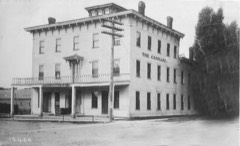 | Cadillac House | building | 2018 | 100003216 |
 | John Divine Law Office/Moore Public Library | building | 1985 | 85000167 |
 | John L. Fead House | building | 1978 | 78001510 |
 | Joseph M. Loop House | building | 1972 | 72000654 |
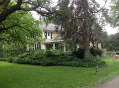 | Thomas and Margaret Spencer Matthews Farm | district | 1995 | 95000371 |
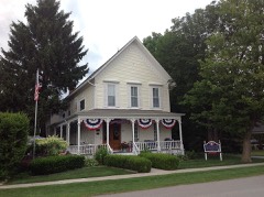 | Moore, Charles H./Sleeper, Albert E., House | building | 1985 | 85000064 |
 | William Reuben Nims House | building | 1985 | 85000719 |
 | Port Sanilac Light Station | building | 1984 | 84001842 |
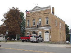 | Port Sanilac Masonic and Town Hall | building | 1996 | 96000808 |
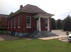 | W.R. Roach Cannery Warehouse and Office Building | building | 2005 | 05000717 |
Every wildfire the federal occurrence database records inside this county: 42 of them, burning about 272 acres. 4 started naturally and 2 were recorded as arson. Each settlement page carries the fires within five miles of it.
| Reported cause | Fires |
|---|---|
| Missing data/not specified/undetermined | 15 |
| Equipment and vehicle use | 12 |
| Natural | 4 |
| Smoking | 4 |
| Debris and open burning | 3 |
| Arson/incendiarism | 2 |
| Recreation and ceremony | 1 |
| Fireworks | 1 |
The five largest, by the area the report gives. Two of them were set deliberately.
| Date | Cause | Size | Reported by | Name on the report |
|---|---|---|---|---|
| 12 September 2003 | Missing data/not specified/undetermined | 116 acres | Michigan Department of Natural Resources | MINDEN CITY MUCK FIRE 03 |
| 13 May 2001 | Fireworks | 40 acres | Michigan Department of Natural Resources | not named |
| 26 March 2018 | Equipment and vehicle use | 30 acres | Michigan Department of Natural Resources | ELK TOWNSHIP FIRE/RESCUE 1113 - 2018 |
| 21 August 2019 | Equipment and vehicle use | 10 acres | Michigan Department of Natural Resources | CROSWELL FD 2019094 - 2019 |
| 8 October 2002 | Arson/incendiarism | 9.5 acres | Michigan Department of Natural Resources | not named |
| 17 April 2005 | Debris and open burning | 9.0 acres | Michigan Department of Natural Resources | not named |
| 15 June 2012 | Natural | 8.0 acres | Michigan Department of Natural Resources | SANILAC 02 |
| 20 April 1996 | Arson/incendiarism | 8.0 acres | Michigan Department of Natural Resources | not named |
Every settlement page carries the fires within five miles of it - see the settlement index below.
The NOAA Storm Events Database holds 241 reports for this county, causing 2 deaths, 3 injuries and about $8,024,030 in recorded property damage. Each settlement page carries the reports that name it.
| Kind of event | Reports |
|---|---|
| Thunderstorm Wind | 143 |
| Hail | 64 |
| Tornado | 21 |
| Flash Flood | 5 |
| Lightning | 5 |
| Flood | 2 |
| Waterspout | 1 |
The most serious of them, by death, then injury, then recorded damage. The accounts are quoted exactly as the forecast office filed them.
| When | Event | Place named | Harm | What the report says |
|---|---|---|---|---|
| August 1988 | Thunderstorm Wind | not stated | 2 killed, 1 hurt | no account filed |
| September 1984 | Tornado (F3) | not stated | 1 hurt, $2,500,000 | no account filed |
| October 2002 | Thunderstorm Wind | Deckerville | 1 hurt | Trained spotters reported that thunderstorm winds blew down several large trees onto a major road. A Deckerville man was seriously injured when he ran into one of these trees on his motorcycle. |
| August 2006 | Flash Flood | Brown City | $1,250,000 | Thunderstorms with very heavy rain repeatedly occurred across the same areas and dumped rain at a rate of nearly 2 inches per hour. Doppler radar estimated that 5 inches of rain fell in a west to east swath across southeast Sanilac County, and as much as 10 inches in an isolated area in and around the Brown City area. A cooperative observer in Brown City actually measured 7.35 inches over a 4 hour period on the evening of August 2nd, with an additional eight tenths of an inch falling after midnight during the early morning hours of the 3rd. The most intense rain fell from about 2000 EST on the 2nd to about 0100 EST on the 3rd. Flash flooding began around 2300 EST. Many homes in the Brown City area were heavily damaged by flood waters. The entire town experienced flooding and the city manager reported 220 damage claims filed with the city. At least 3 basements were lost and and a few homes reported nearly $100K in damages. The entire lower half of the high school was flooded with 3 to 5 inches of water. Flood waters reached 3 feet deep in a mobile home park in the city. Around 0200 EST on the 3rd, the flood waters stopped rising, and by noon, the flood waters began to recede. Total property damages were estimated at $1.25M. No injuries were reported. |
| November 2019 | Flood | Forestville | $1,000,000 | no account filed |
| June 1996 | Flash Flood | Srn 1/2 Of Co. | $800,000 | no account filed |
| June 2015 | Tornado (EF1) | Hemans | $500,000 | A tornado touched briefly down in Tuscola county, then tracked mostly in a west to east direction parallel to and just south of Deckerville road in Sanilac County. Most damage along the path was rated EF0 intensity and below 85 mph, bringing down trees and power lines. However, a pocket of EF1 damage occurred with maximum intensity around 110 mph on the north side of Decker, extending west toward the Tuscola Border. Major damage occurred to Devor Dairy Farm. The total path length of the tornado came in close to 23 miles, with just 1 mile of the path length occurring in Tuscola County. |
| April 1998 | Tornado (F1) | Carsonville | $350,000 | no account filed |
| July 1995 | Thunderstorm Wind | Countywide | $300,000 | no account filed |
| June 1982 | Tornado (F1) | not stated | $250,000 | no account filed |
| September 1996 | Hail | Decker | $150,000 | no account filed |
| June 2010 | Tornado (EF0) | Marlette | $75,000 | A tornado occurred near Marlette in western Sanilac County. This weak tornado occurred at approximatley 832 pm and produced winds to 75 mph and was rated EF0. The tornado touched down on the southeast side of Marlette on Euclid Avenue and continued for a half mile before dissipating. Four trees were snapped off and one shed was destroyed, along with downed branches and shingle loss on one home. |
| August 1993 | Thunderstorm Wind | Port Sanilac | $50,000 | Thunderstorm winds uprooted numerous large trees, up to 2 feet in diameter. Scattered light damage to a few houses occurred due to downed trees. One automobile was heavily damaged by a falling tree. |
| May 2011 | Lightning | Brown City | $50,000 | no account filed |
| May 1999 | Thunderstorm Wind | Deckerville | $50,000 | no account filed |
| July 1999 | Lightning | New Greenleaf | $45,000 | Lightning-induced fires caused two barns to burn to the ground. |
| November 2015 | Tornado (EF1) | Cash | $40,000 | An NWS damage survey determined that a tornado began about 0.5 miles east of the intersection of Marlette and Loeding Roads 6.5 miles west-southwest of Applegate. Near the corner of Marlette and Ruth Roads, the tornado destroyed the roof and two walls of a manufactured single-wide home. Extensive tree damage occurred east of there. The tornado also destroyed 3 small barns before lifting in a field just northeast of the intersection of Marlette and Tubbs Roads. Peak winds were estimated to be 90 mph. |
| June 2008 | Thunderstorm Wind | Sandusky City Arpt | $40,000 | Trees reported down. |
| December 1998 | Thunderstorm Wind | Marlette | $40,000 | no account filed |
| July 2000 | Flash Flood | Marlette | $35,000 | no account filed |
| June 2002 | Lightning | Sandusky | $30,000 | Lightning struck a barn in Watertown Township and set it on fire. |
| May 1998 | Thunderstorm Wind | Minden City | $30,000 | no account filed |
| July 1999 | Thunderstorm Wind | Amadore | $26,000 | no account filed |
| May 1999 | Thunderstorm Wind | Sandusky | $25,000 | no account filed |
| May 1998 | Thunderstorm Wind | New Greenleaf | $25,000 | no account filed |
| June 1982 | Tornado (F1) | not stated | $25,000 | no account filed |
| July 1977 | Tornado (F1) | not stated | $25,000 | no account filed |
| July 1972 | Tornado (F1) | not stated | $25,000 | no account filed |
| July 2011 | Thunderstorm Wind | Croswell | $20,000 | Numerous trees and powerlines blown down. |
| May 2004 | Tornado (F0) | Deckerville | $20,000 | A tornado blew apart 2 barns along Richmondville road near Burgess and Hunt Roads. |
| May 1998 | Thunderstorm Wind | Shabbona | $20,000 | no account filed |
| August 2009 | Thunderstorm Wind | Snover | $15,000 | An empty silo was blown down, along with several tree tops blown off. |
| July 2006 | Thunderstorm Wind | Sandusky | $15,000 | A local newspaper article included a picture of a large tree blown down on top of a vehicle parked next to a home. A camper and pickup truck were also damaged by the fallen tree. Property damage is roughly estimated at $15K. No injuries were reported. |
| July 2000 | Lightning | Sandusky | $15,000 | A lightning strike ignited a fire that partially destroyed a barn. |
| May 1998 | Thunderstorm Wind | Croswell | $15,000 | no account filed |
| May 1998 | Thunderstorm Wind | Peck | $15,000 | no account filed |
| May 2013 | Thunderstorm Wind | Deckerville | $10,000 | Trees blown down. One barn was also blown down, along with the roof blown off a second barn. |
| May 1999 | Thunderstorm Wind | Marlette | $10,000 | no account filed |
| May 1998 | Thunderstorm Wind | Marlette | $10,000 | no account filed |
| July 2006 | Thunderstorm Wind | New Greenleaf | $8,000 | A local newspaper included pictures of several small trees uprooted at a residence along Cleland Road in northwest Sanilac County. Two barn roofs also sustained some damage. A strong downburst, associated with a pulse severe thunderstorm, generated wind gusts estimated at 65 MPH in a localized area. Property damage was estimated by owner at around $8K. |
| July 1999 | Thunderstorm Wind | Peck | $8,000 | no account filed |
| June 2020 | Thunderstorm Wind | Brown City | $5,000 | A couple of trees were snapped, with a church roof partially peeled off. |
| July 2016 | Thunderstorm Wind | Argyle | $5,000 | Large trees and numerous power lines reported down. |
| May 2014 | Thunderstorm Wind | Deckerville | $5,000 | Power lines and power poles reported down. |
| May 2014 | Thunderstorm Wind | Melvin | $5,000 | A power pole and wires reported down. |
| May 2014 | Thunderstorm Wind | Brown City | $5,000 | Power lines and power poles reported down. |
| May 2014 | Thunderstorm Wind | Croswell | $5,000 | Power lines and power poles reported down. |
| July 2013 | Thunderstorm Wind | Deckerville | $5,000 | Trees and power lines down. |
| June 2008 | Thunderstorm Wind | New Greenleaf | $5,000 | Trees reported down. |
| June 2008 | Thunderstorm Wind | Sandusky | $5,000 | Wires reported down. |
| June 2002 | Lightning | Sandusky | $5,000 | Lightning struck a barn and caused minor damage. |
| May 1999 | Thunderstorm Wind | Deckerville | $5,000 | no account filed |
| May 1998 | Thunderstorm Wind | Sandusky | $5,000 | no account filed |
| September 1996 | Hail | Tyre | $5,000 | no account filed |
| September 2016 | Thunderstorm Wind | Peck | $4,000 | Trees and power lines reported down. |
| April 2009 | Thunderstorm Wind | Lexington | $4,000 | Numerous tree limbs and powerlines down in the area. |
| July 2008 | Thunderstorm Wind | Juhl | $3,000 | Trees and large branches reported down. |
| July 2000 | Thunderstorm Wind | Deckerville | $3,000 | no account filed |
| May 1999 | Thunderstorm Wind | Melvin | $3,000 | no account filed |
| December 1998 | Thunderstorm Wind | Lexington | $3,000 | no account filed |
The Survey's mineral resources record lists 20 workings inside this county. 4 still produce and 16 are closed or unrecorded. Each settlement page carries the workings within five miles of it.
| Commodity | Workings |
|---|---|
| Sand and Gravel, Construction | 17 |
| Fire Clay (Refractory) | 3 |
The least common of them first, because a county's hundredth gravel pit says nothing its first ten did not.
| Where | Site | Commodity | Status | Recorded |
|---|---|---|---|---|
| Large's Clay Pit | Fire Clay (Refractory) | Past Producer | ||
| Port Huron Clay Prod Co.Clay Pit | Fire Clay (Refractory) | Past Producer | ||
| Sandusky Tile and Brick Co.Clay Pit | Fire Clay (Refractory) | Past Producer | ||
| Albrecht Pit and Mill | Sand and Gravel, Construction | Producer | ||
| Cook Block Co. Pit | Sand and Gravel, Construction | Producer | ||
| Sanilac County Road Commission | Sand and Gravel, Construction | Past Producer | ||
| Sanilac County Road Commission Pit | Sand and Gravel, Construction | Past Producer | ||
| Sanilac County Road Commission Pit | Sand and Gravel, Construction | Past Producer | ||
| Sanilac County Road Commission Pit | Sand and Gravel, Construction | Past Producer | ||
| Sanilac County Road Commission Pit | Sand and Gravel, Construction | Past Producer | ||
| Sanilac County Road Commission Pit | Sand and Gravel, Construction | Past Producer | ||
| Sanilac County Road Commission Pit | Sand and Gravel, Construction | Past Producer | ||
| Sanilac County Road Commission Pit | Sand and Gravel, Construction | Past Producer | ||
| Sanilac County Road Commission Pit | Sand and Gravel, Construction | Past Producer | ||
| Sanilac County Road Commission Pit | Sand and Gravel, Construction | Past Producer | ||
| Sanilac County Road Commission Pit | Sand and Gravel, Construction | Past Producer | ||
| Sanilac County Road Commission Pit | Sand and Gravel, Construction | Past Producer | ||
| Sanilac County Road Commission Pit | Sand and Gravel, Construction | Past Producer | ||
| Shipley Pit and Wash Plant | Sand and Gravel, Construction | Producer | ||
| Worth Pit | Sand and Gravel, Construction | Producer |
Named settlements recorded in the Geographic Names Information System, each with the topographic sheets covering it. Villages, hamlets and abandoned places alike. Each is shown with the nearest named watercourse or landform and the survey quadrangle it falls on.
Austin township · 48475 · On Franzel Drain · Argyle quadrangle
10 sheets, 1954 to 1984
Forester township · 48419 · On Forester Creek · Port Sanilac quadrangle
9 sheets, 1954 to 1984
Delaware township · 48434 · On Mill Creek · Forestville quadrangle
10 sheets, 1954 to 1984
Greenleaf township · 48726 · On Greenleaf Creek · New Greenleaf quadrangle
8 sheets, 1954 to 1984
Sanilac township · 48401 · On Pine Hill Stream · Croswell quadrangle
10 sheets, 1954 to 1984
No longer a settlement
Sanilac township · 48469 · On Liens Creek · Port Sanilac quadrangle
9 sheets, 1954 to 1984
Forester township · 48427 · On Indian Creek · Richmondville quadrangle
9 sheets, 1954 to 1984
Evergreen township · 48426 · On Middle Branch Cass River · Shabbona quadrangle
8 sheets, 1954 to 1984
The vanished settlements of Sanilac County: the places named above that are no longer on the map.