 Block
From the record
4 National Register listings published here.
Sources: the National Register database, National Park Service
58 topographic sheets cover 27 settlements here, and 4 properties are on the National Register of Historic Places.
4 National Register listings published here.
Sources: the National Register database, National Park Service
Every property in this county listed on the National Register of Historic Places, with the year it was listed and the federal nomination document.
| Photograph | Property | Type | Listed | Reference |
|---|---|---|---|---|
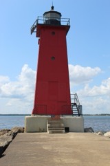 | Manistique East Breakwater Light | structure | 2005 | 05000980 |
 | Manistique Pumping Station | structure | 1981 | 81000316 |
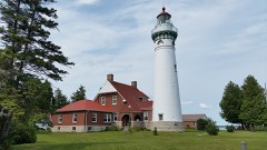 | Seul Choix Pointe Light Station | building | 1984 | 84001846 |
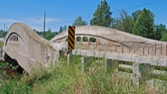 | Ten Curves Road-Manistique River Bridge | structure | 1999 | 99001538 |
Every wildfire the federal occurrence database records inside this county: 174 of them, burning about 4,182 acres. 45 started naturally and 9 were recorded as arson. Each settlement page carries the fires within five miles of it.
| Reported cause | Fires |
|---|---|
| Natural | 45 |
| Missing data/not specified/undetermined | 39 |
| Debris and open burning | 36 |
| Recreation and ceremony | 21 |
| Arson/incendiarism | 9 |
| Equipment and vehicle use | 8 |
| Power generation/transmission/distribution | 5 |
| Smoking | 4 |
| Railroad operations and maintenance | 3 |
| Fireworks | 3 |
| Misuse of fire by a minor | 1 |
The five largest, by the area the report gives. One of them was set deliberately.
| Date | Cause | Size | Reported by | Name on the report |
|---|---|---|---|---|
| 21 May 2012 | Natural | 3,400 acres | Seney National Wildlife Refuge | PINE CREEK NORTH |
| 5 July 2006 | Natural | 63 acres | Seney National Wildlife Refuge | COLD CREEK |
| 2 May 1992 | Debris and open burning | 63 acres | Michigan Department of Natural Resources | not named |
| 10 July 1994 | Arson/incendiarism | 61 acres | Michigan Department of Natural Resources | not named |
| 31 March 1995 | Debris and open burning | 46 acres | Michigan Department of Natural Resources | not named |
| 6 August 2005 | Natural | 45 acres | Hiawatha National Forest | LAW |
| 20 March 2012 | Debris and open burning | 36 acres | Hiawatha National Forest | LEG LAKE |
| 30 August 2007 | Natural | 27 acres | Seney National Wildlife Refuge | HICKEY CREEK |
Every settlement page carries the fires within five miles of it - see the settlement index below.
The NOAA Storm Events Database holds 94 reports for this county, causing no deaths, 2 injuries and about $1,319,000 in recorded property damage. Each settlement page carries the reports that name it.
| Kind of event | Reports |
|---|---|
| Hail | 44 |
| Thunderstorm Wind | 39 |
| Heavy Rain | 7 |
| Tornado | 3 |
| Funnel Cloud | 1 |
The most serious of them, by death, then injury, then recorded damage. The accounts are quoted exactly as the forecast office filed them.
| When | Event | Place named | Harm | What the report says |
|---|---|---|---|---|
| July 1984 | Tornado (F2) | not stated | 1 hurt, $25,000 | no account filed |
| July 1984 | Thunderstorm Wind | not stated | 1 hurt | no account filed |
| October 1997 | Thunderstorm Wind | Cooks | $600,000 | A bow echo moved rapidly east through Delta and Schoolcraft Counties producing a series of damaging microbursts. The damaging winds started around Rock and proceeded east in a 12 mile wide swath that included Rapid River, Maplewood, and Garden Corners in Delta County; and Cooks, Thompson, Indian Lake, Manistique and Gulliver in Schoolcraft County. Several thousands of trees were downed by the winds, which were estimated to be in excess of 100 miles an hour. 600 buildings sustained wind and hail damage along with numerous vehicles.The most severe property damage locations included Maplewood, Thompson, 7 miles northeast of Manistique and 4 miles west of Gulliver. In Maplewood, a mobile home had its roof blown off and foundation shifted. Two sections of the Hiawatha National Forest suffered extensive tree damage. Those areas were along Delta County Road 509 between Rapid River and Haymeadow Falls (8 N of Rapid River) and east of Indian Lake north of Manistique in Schoolcraft County where 18 areas of damage were located. The U. S. Forest Service estimated 9000 acres of forest very seriously damaged in Delta County with 30 million board feet of timber down and a net loss of $2.25 million. The Michigan Department of Natural Resources suffered 500 acres of tree loss in Schoolcraft County between Cooks and Thompson with a net loss of $500 thousand. Corporate owned forest land also suffered over 200 acres of tree loss valued at $113 thousand between Cooks and Wiggins Point on the Garden Peninsula and near Gulliver. In Thompson, several trees, mostly 8-16 inch diameter pines, were snapped off between 6 and 12 feet above the ground. Three vehicles and several hundred structures sustained wind and/or hail damage. Northeast of Manistique, a roof was blown off a large metal garage and metal barn and a 30 inch diameter pine tree fell puncturing a roof on a house. Four miles west of Gulliver, a garage was destroyed by high winds. Other damage included a pole garage one mile east of Rock. |
| July 2023 | Thunderstorm Wind | Steuben | $500,000 | A WFO Marquette storm survey team observed widespread microburst damage around Straits Lake in Schoolcraft County on the evening of the 10th. Significant tree damage was observed, including uprooted and snapped large pine trees. In addition, multiple trees had fallen on some structures and vehicles. |
| October 1997 | Hail | Cooks | $100,000 | Hail damaged several homes and vehicle in the city of Manistique. |
| July 2021 | Thunderstorm Wind | Steuben | $40,000 | A microburst struck Indian River Campground southeast of Steuben in Schoolcraft County on the afternoon of the 14th. Over 50 large trees were snapped or uprooted over a 300 x 200 yard area. Maximum wind speeds were estimated at 85 mph. Fortunately, all of the campsites were empty at the time of the storm. |
| July 1987 | Tornado (F3) | not stated | $25,000 | no account filed |
| July 1999 | Thunderstorm Wind | Indian Lake | $10,000 | Damage to camping trailers. |
| June 2024 | Thunderstorm Wind | Gulliver | $5,000 | Eight 12-inch diameter trees were snapped and uprooted by thunderstorm outflow winds from decaying cluster of thunderstorms to the west. Report was from social media. |
| June 2024 | Thunderstorm Wind | Ossawinamakee Beach | $3,000 | Delayed report from Facebook of trees and branches down near Indian Lake. Time was estimated from radar. |
| July 2006 | Thunderstorm Wind | Seney | $3,000 | Several trees down along Highway M-77 and adjoining side roads. |
| June 2017 | Thunderstorm Wind | Manistique | $2,000 | There was a delayed report from the local hospital emergency coordinator of several trees down in and around Manistique resulting in power outages around town and at the hospital. |
| July 2007 | Thunderstorm Wind | Cooks | $2,000 | Numerous trees knocked down in the vicinity of Cooks. |
| July 2006 | Thunderstorm Wind | Manistique | $2,000 | Trees and power lines down near Indian Lake. |
| June 2025 | Thunderstorm Wind | Hiawatha | $1,000 | Public report of a tree blocking Southside Rd a half mile north of M-94. Time approximated by broadcast media who forwarded the report. |
| July 2016 | Thunderstorm Wind | Ossawinamakee Beach | $1,000 | There was a delayed report of three fruit trees of approximately six inches in diameter uprooted. |
| June 2024 | Thunderstorm Wind | Manistique Arpt | - | A MDOT mesonet station near Manistique reported a thunderstorm wind gust of 58 mph. |
| June 2024 | Hail | Scotts | - | A public report of observed and measured tennis ball sized hail along White Head Road and Forest Service Highway 13 near the Alger and Schoolcraft County line. Time of the report was estimated from radar. |
| June 2024 | Hail | Scotts | - | Two-inch diameter hail was reported eight miles west-northwest of Steuben. A photo was sent of a hailstone about 30-45 minutes after it fell so some melting occurred. Time of the report was estimated from radar. |
| August 2020 | Hail | Manistique | - | There was a public report of nickel-sized hail in Manistique. |
| August 2018 | Funnel Cloud | Indian Lake | - | The Director of Public Safety for Manistique submitted a photo of a funnel cloud near Manistique. The time of the report was estimated from radar. |
| July 2016 | Heavy Rain | Manistique | - | A trained spotter measured 2.46 inches of rainfall in Manistique in less than 12 hours. |
| July 2016 | Hail | Ossawinamakee Beach | - | There was a public report of penny-sized hail four miles northwest of Manistique. |
| July 2016 | Hail | Indian Lake | - | There was public report of estimated one inch diameter hail west of Indian Lake. The observer arrived onsite around 30 minutes after the hail had fallen and found nickel-sized hail covering the ground at the time. |
| August 2015 | Hail | (P75)Seul Choix Pt | - | Dime to penny sized hail observed. |
| December 2015 | Heavy Rain | Manistique | - | Two-day rainfall totals across the county generally ranged between two and three inches with the highest amounts reported near Manistique in southern Schoolcraft County. |
| September 2014 | Hail | Germfask | - | There was a delayed public report of golf ball sized hail near Germfask. Hail size was estimated between 1.50 and 1.75 inches with hail nearly covering the ground. |
| August 2014 | Heavy Rain | Germfask | - | The mesonet station at Germfask measured 2.10 inches of rainfall in 36 hours. |
| September 2014 | Heavy Rain | Manistique | - | There was a public report of 2.79 inches of rain at Manistique in approximately 10 hours. Germfask measured 2.56 inches over the same period. |
| July 2013 | Heavy Rain | Cooks | - | The observer near Cooks measured over five inches of rainfall over an approximate 24-hour period. Over five inches of rain also fell in Manistique. |
| July 2013 | Hail | Thompson | - | Penny to nickel-sized hail was reported along with 40 mph wind gusts. |
| June 2012 | Heavy Rain | Cooks | - | The observer near Cooks measured 2.06 inches of rainfall. |
| June 2012 | Hail | (P75)Seul Choix Pt | - | Hail measured at 1.5 inches in diameter fell at the Seul Choix Point Lighthouse. |
| June 2012 | Heavy Rain | Manistique Arpt | - | The spotter four miles west of Gulliver measured 1.90 inches of storm total rainfall. |
| July 2010 | Thunderstorm Wind | Ossawinamakee Beach | - | A six-inch diameter tree limb was reported down on Birch Street near Indian Lake, MI. Storms also dumped three to four inches of rain between Manistique and Gulliver. |
| June 2010 | Thunderstorm Wind | Scotts | - | Downed trees were observed along Highway 94 north of Steuben. |
| June 2010 | Hail | Germfask | - | Small branches were also snapped from trees. |
| May 2009 | Hail | Hiawatha | - | The hail lasted about four minutes and covered the ground. |
| June 2007 | Thunderstorm Wind | Steuben | - | One tree down on Triangle Lake. |
| July 2006 | Hail | Thompson | - | Quarter-sized hail reported. |
| July 2006 | Thunderstorm Wind | Manistique | - | Two large trees down |
| July 2006 | Thunderstorm Wind | Manistique | - | A few large trees blown down along Highway M-94 just north of the Indian River Bridge. |
| August 2005 | Thunderstorm Wind | Steuben | - | Awnings blown off campers. Trees down. |
| June 2004 | Thunderstorm Wind | Manistique | - | Trees were blown down across power lines. |
| July 2004 | Hail | Manistique | - | Golf ball-sized hail was reported. |
| August 2004 | Hail | Steuben | - | Nickel sized hail was reported. |
| July 2003 | Hail | Steuben | - | Three-quarter inch hail was reported. |
| August 2003 | Thunderstorm Wind | Seney | - | Several trees were blown down along highway M-77. |
| June 2002 | Hail | Germfask | - | Three quarter inch hail was reported. |
| June 2002 | Thunderstorm Wind | Steuben | - | Several large trees were uprooted. |
| July 2002 | Thunderstorm Wind | Manistique | - | Numerous trees and power lines were blown down. |
| July 2002 | Thunderstorm Wind | Steuben | - | A 10 inch diameter tree branch was broken off. |
| July 2002 | Hail | Seney | - | Penny sized hail was reported. |
| October 2002 | Thunderstorm Wind | Manistique | - | A 61 mph wind gust was recorded. |
| August 2002 | Thunderstorm Wind | Steuben | - | A one foor diameter tree was blown down. |
| July 2002 | Thunderstorm Wind | Gulliver | - | One to two inch diameter tree branches were broken off. |
| October 2002 | Thunderstorm Wind | Manistique | - | Trees and power lines were blown down. Broken power lines started a fire. |
| May 2001 | Thunderstorm Wind | Seney | - | 8 inch diameter trees down. |
| June 2001 | Hail | Steuben | - | Dime sized hail. |
| July 2001 | Thunderstorm Wind | Steuben | - | Large tree down across the road. |
The Survey's mineral resources record lists 11 workings inside this county. 10 still produce and 1 is closed or unrecorded. Each settlement page carries the workings within five miles of it.
| Commodity | Workings |
|---|---|
| Sand and Gravel, Construction | 6 |
| Dolomite | 2 |
| Stone, Crushed/Broken | 1 |
| Limestone, Dimension | 1 |
| Limestone, General | 1 |
The least common of them first, because a county's hundredth gravel pit says nothing its first ten did not.
| Where | Site | Commodity | Status | Recorded |
|---|---|---|---|---|
| Inland Lime & Stone | Stone, Crushed/Broken | Producer | ||
| Inwood Stone Products Co. Quarry | Limestone, Dimension | Producer | ||
| West Hical Quarry | Limestone, General | Producer | 1930 | |
| Dolomite Quarry | Dolomite | Producer | 1930 | |
| White Marble Lime Co.Quarry | Dolomite | Past Producer | ||
| Blaney Park Pit No 30 | Sand and Gravel, Construction | Producer | ||
| Currans Pit | Sand and Gravel, Construction | Producer | ||
| Neadow Pit | Sand and Gravel, Construction | Producer | ||
| Schoolcraft County Road Comm. Pit | Sand and Gravel, Construction | Producer | ||
| State of Michigan Pit | Sand and Gravel, Construction | Producer | ||
| Stoney Cut No. 19 Quarry | Sand and Gravel, Construction | Producer |
Named settlements recorded in the Geographic Names Information System, each with the topographic sheets covering it. Villages, hamlets and abandoned places alike. Each is shown with the nearest named watercourse or landform and the survey quadrangle it falls on.
Mueller township · 49840 · On Four Hundred and Five Creek · Blaney Park quadrangle
11 sheets, 1931 to 1985
Mueller township · 49836 · On Pelky Creek · Blaney Park quadrangle
11 sheets, 1931 to 1985
Manistique city · 49854 · On Manistique River · Manistique East quadrangle
6 sheets, 1954 to 1983
Thompson township · 49854 · On Dufour Creek · Manistique West quadrangle
8 sheets, 1931 to 1983
Thompson township · 49854 · On Dufour Creek · Manistique West quadrangle
8 sheets, 1931 to 1983
Thompson township · 49854 · On Iron Creek · Thunder Lake quadrangle
11 sheets, 1931 to 1983
Thompson township · 49854 · On Williams Creek · Manistique West quadrangle
8 sheets, 1931 to 1983