 Block
From the record
9 National Register listings published here.
Sources: the National Register database, National Park Service
47 topographic sheets cover 22 settlements here, and 9 properties are on the National Register of Historic Places.
9 National Register listings published here.
Sources: the National Register database, National Park Service
Every property in this county listed on the National Register of Historic Places, with the year it was listed and the federal nomination document.
| Photograph | Property | Type | Listed | Reference |
|---|---|---|---|---|
 | Cadillac Public Library | building | 2007 | 07001020 |
 | Cobbs and Mitchell Building | building | 2010 | 10000479 |
 | Frank J. Cobbs House | building | 1988 | 88000376 |
| Cooley School | building | 2026 | 100012597 | |
 | Elks Temple Building | building | 1988 | 88001835 |
 | Masonic Temple Building | building | 1994 | 94000747 |
 | Charles T. Mitchell House | building | 1986 | 86003369 |
 | Old Cadillac City Hall | building | 1986 | 86001380 |
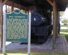 | Shay Locomotive | structure | 1981 | 81000321 |
Every wildfire the federal occurrence database records inside this county: 358 of them, burning about 973 acres. 14 started naturally and 22 were recorded as arson. Each settlement page carries the fires within five miles of it.
| Reported cause | Fires |
|---|---|
| Missing data/not specified/undetermined | 94 |
| Debris and open burning | 85 |
| Recreation and ceremony | 49 |
| Equipment and vehicle use | 28 |
| Power generation/transmission/distribution | 24 |
| Arson/incendiarism | 22 |
| Smoking | 21 |
| Misuse of fire by a minor | 15 |
| Natural | 14 |
| Railroad operations and maintenance | 4 |
| Other causes | 2 |
The five largest, by the area the report gives. Two of them were set deliberately.
| Date | Cause | Size | Reported by | Name on the report |
|---|---|---|---|---|
| 16 April 2008 | Debris and open burning | 133 acres | Huron-Manistee National Forest | HOXEYVILLE |
| 29 August 2018 | Arson/incendiarism | 79 acres | Michigan Department of Natural Resources | WEXFORD 04 - BOND MILL POND |
| 18 May 1996 | Recreation and ceremony | 70 acres | Huron-Manistee National Forest | HOXEYVILLE |
| 27 May 1997 | Smoking | 43 acres | Huron-Manistee National Forest | NORTH PETERSON BRIDG |
| 31 March 1994 | Debris and open burning | 43 acres | Michigan Department of Natural Resources | not named |
| 24 March 2003 | Railroad operations and maintenance | 34 acres | Huron-Manistee National Forest | DAISEY LANE |
| 23 March 2003 | Debris and open burning | 23 acres | Michigan Department of Natural Resources | not named |
| 23 April 1994 | Arson/incendiarism | 22 acres | Michigan Department of Natural Resources | not named |
Every settlement page carries the fires within five miles of it - see the settlement index below.
The NOAA Storm Events Database holds 126 reports for this county, causing no deaths, 1 injury and about $2,094,000 in recorded property damage. Each settlement page carries the reports that name it.
| Kind of event | Reports |
|---|---|
| Thunderstorm Wind | 68 |
| Hail | 38 |
| Flash Flood | 9 |
| Tornado | 8 |
| Flood | 2 |
| Lightning | 1 |
The most serious of them, by death, then injury, then recorded damage. The accounts are quoted exactly as the forecast office filed them.
| When | Event | Place named | Harm | What the report says |
|---|---|---|---|---|
| June 1974 | Tornado (F2) | not stated | 1 hurt, $25,000 | no account filed |
| June 2008 | Flash Flood | Hoxeyville | $750,000 | Widespread flooding developed in southern Wexford County, with isolated flooding in the north, thanks to three to six inches of rainfall in a few hours either side of midnight. Numerous roads were washed out, especially on the northwest side of Lake Cadillac, and near and north of Mesick. One hundred and fifty homes were impacted by high water. |
| October 2006 | Tornado (F0) | Benson | $260,000 | A brief tornado occurred west of Cadillac, along Benson Road just south of M-55. A garage and part of a kitchen was ripped off of a home and destroyed. The owner was asleep in a bedroom on the other side of the house, and was not injured. An aluminum shed in the yard was wrapped around a tree. A home across the street was shifted slightly off its foundation. A few other nearby homes suffered shingle damage. Several large pine trees were uprooted. |
| October 1989 | Tornado (F1) | not stated | $250,000 | no account filed |
| July 1963 | Tornado (F2) | not stated | $250,000 | no account filed |
| April 2014 | Flood | Lake Cadillac | $110,000 | Two areas of concentrated flooding occurred in Wexford County, with a number of road closures. One was along Lake Mitchell, just west of Cadillac. The other was along the Manistee River in far northern sections of the county. Water entered multiple homes at both locations. |
| July 2012 | Flash Flood | Haring | $40,000 | Thunderstorms dumped around 4 inches of rain along the M-115 corridor in Wexford County. Cadillac picked up 3.12 inches of rain between 9 and 11 pm EDT, while Meauwataka had a total of 4.10 inches by morning. Northwest of Cadillac, over two feet of water covered roads at the intersection of M-115 and East 35 Road. In the Mesick area, M-37 was partially washed out, reducing traffic to one lane. |
| June 2008 | Flood | Harrietta Bunch Arpt | $40,000 | Flooding lingered for several days after the heavy rain event ended, mainly on the Manistee River and its larger tributaries. The Manistee River at Sherman established a new flood of record on the 14th, reaching 16.4 feet. Several homes just above Hodenpyl Dam Pond had to be evacuated. |
| June 2007 | Thunderstorm Wind | Cadillac | $35,000 | Numerous trees and power lines downed. Several vehicles, and the roof of a residence, were heavily damaged by falling trees. |
| October 2007 | Thunderstorm Wind | Cadillac | $35,000 | Several trees and large limbs were knocked down in Cadillac. One mobile home in Country Acres was destroyed by a falling tree. |
| August 2018 | Thunderstorm Wind | Axin | $30,000 | Multiple trees were downed west of Cadillac, blocking some roads in the area. |
| October 2007 | Thunderstorm Wind | Sherman | $30,000 | A number of trees were downed by thunderstorm winds. Four vehicles were destroyed or damaged by falling trees. |
| June 1976 | Tornado (F1) | not stated | $25,000 | no account filed |
| July 2006 | Thunderstorm Wind | Manton | $20,000 | A falling tree destroyed the office of the Lake Billings Campground. |
| May 2004 | Flash Flood | Cadillac | $20,000 | Water was over a foot deep on Mitchell Street in Cadillac. |
| August 2018 | Thunderstorm Wind | Meauwataka | $14,000 | Sporadic pockets of trees and power lines downed in central Wexford County. |
| July 2012 | Flash Flood | Cadillac Wexford Arp | $12,000 | Four inches of rain fell in just two hours on downtown Cadillac. This resulted in rapidly flowing water on Mitchell Street, and in other parts of the downtown area. Water entered some businesses. Some intersections had 1 to 2 feet of water. |
| April 2011 | Thunderstorm Wind | Hobart | $12,000 | A large tree was downed across a road, shingles were removed from a few homes, a steel carport was blown down, and a shed was moved about 40 feet. |
| June 2008 | Thunderstorm Wind | Mesick | $12,000 | Two spotters estimated winds at 60 mph. Several trees were downed, and a pole barn was partially unroofed. |
| July 2018 | Thunderstorm Wind | Cadillac | $11,000 | Numerous trees and large limbs were downed in Cadillac. Some power outages resulted. |
| November 2013 | Flash Flood | Lake Mitchell | $10,000 | Rainfall amounts of just over two inches in an hour produced short-lived urban flooding in Cadillac. Numerous streets were impassible. |
| March 2012 | Thunderstorm Wind | Missaukee Jct | $9,000 | A pontoon boat was flipped, and siding ripped off a home, in the Long Lake area. Soon after, a 63 mph wind gust was measured at the Wexford County Airport. |
| July 2010 | Tornado (EF0) | Lake Cadillac | $8,000 | A brief EF0 tornado touchdown occurred south of Cadillac. The only property damage was the loss of a roof from an outbuilding at a lumber yard. Maximum winds were estimated at 65 mph. |
| August 2022 | Thunderstorm Wind | Cadillac | $7,500 | Central dispatch reports trees and powerlines down across Wexford county. Time estimated by radar. |
| October 2006 | Thunderstorm Wind | Cadillac | $7,000 | Trees and power lines downed. Several road signs blown over along US-131. |
| June 2007 | Thunderstorm Wind | Manton | $6,000 | Numerous trees downed west through northwest of Manton. |
| July 2024 | Thunderstorm Wind | Cadillac | $5,000 | Multiple trees down. |
| July 2024 | Thunderstorm Wind | Cadillac | $5,000 | Trees down over roadway. |
| July 2019 | Thunderstorm Wind | Cadillac | $5,000 | Multiple trees were downed. |
| July 2016 | Thunderstorm Wind | Haring | $5,000 | Large tree limbs and power lines were downed. |
| August 2013 | Thunderstorm Wind | Hobart | $5,000 | Several trees were downed south of Cadillac. |
| October 2006 | Thunderstorm Wind | Mesick | $5,000 | Trees and power lines downed. |
| September 2005 | Thunderstorm Wind | Mesick | $5,000 | Numerous power lines and trees were knocked down. |
| August 2009 | Thunderstorm Wind | Cadillac | $4,500 | A boat on Lake Cadillac was flipped over. Power lines were downed in the city of Cadillac, and a large tree was toppled onto power lines. |
| August 2015 | Thunderstorm Wind | Cadillac | $4,000 | Trees were downed on Wright and Lake Streets in Cadillac. |
| July 2012 | Thunderstorm Wind | Haring | $4,000 | Several trees were downed in Selma and Cherry Grove Townships. |
| September 2011 | Thunderstorm Wind | Baxter | $4,000 | Trees were downed northwest of Manton. |
| June 2016 | Thunderstorm Wind | Buckley | $3,000 | A few trees were downed. |
| July 2012 | Thunderstorm Wind | Manton | $3,000 | Trees and large limbs were downed. |
| August 1968 | Tornado (F1) | not stated | $2,500 | no account filed |
| August 2021 | Thunderstorm Wind | Cadillac | $2,000 | Trees down in Cadillac. Time estimated by radar. |
| July 1995 | Thunderstorm Wind | Cadillac | $2,000 | Several large trees and some power lines were reported blown down by the wind in and around the Cadillac area. |
| July 2017 | Thunderstorm Wind | Lake Mitchell | $1,000 | A tree was downed across Boon Road near M-115. |
| June 2007 | Thunderstorm Wind | Manton | $500 | Several large tree limbs were downed. |
| March 2026 | Hail | Sherman | - | Photo from social media of hail up to ping-pong ball size in Mesick. Additional reports from the Mesick area of accumulating hail mixed with large hailstones. |
| March 2026 | Hail | Meauwataka | - | Photo of several quarter sized hailstones near the intersection of north 25 Rd and west 18 1/2 Rd east of Mesick. |
| July 2025 | Thunderstorm Wind | Manton | - | Central dispatch reported significant power outages in the vicinity of Manton. |
| July 2025 | Thunderstorm Wind | Sherman | - | Central dispatch reported significant power outages in the vicinity of Mesick. |
| August 2024 | Thunderstorm Wind | Cadillac | - | Strong thunderstorm winds downed a portion of a tree onto a house in Cadillac. |
| August 2024 | Thunderstorm Wind | Benson | - | Strong winds downed large trees, resulting in the brief closure of M55 near Cadillac. |
| February 2024 | Hail | Cadillac | - | Accumulating pea-size hail in the area, with hail up to nickel-sized. |
| August 2024 | Thunderstorm Wind | Lake Cadillac | - | Strong thunderstorm winds resulted in widespread tree damage and power outages throughout Wexford county. This resulted in road closures, including both lanes of M115 near Cadillac. |
| July 2023 | Hail | Cadillac Wexford Arp | - | Hail report from Mping. |
| July 2023 | Hail | Meauwataka | - | Hail about the size of quarters falling on M 115 northwest of Cadillac. |
| September 2022 | Hail | Yuma | - | Hail report from mping. |
| April 2008 | Thunderstorm Wind | Manton | - | A spotter estimated a 60 mph wind gust. |
| May 2004 | Hail | Manton | - | An isolated severe thunderstorm produced nickel sized hail near Chase Creek Camp. |
| August 2003 | Thunderstorm Wind | Mesick | - | A tree was downed near M-42. |
| April 2002 | Thunderstorm Wind | Sherman | - | Several trees down. |
| April 2002 | Thunderstorm Wind | Cadillac | - | Power pole snapped in half. |
The Survey's mineral resources record lists 10 workings inside this county. 8 still produce and 2 are closed or unrecorded. Each settlement page carries the workings within five miles of it.
| Commodity | Workings |
|---|---|
| Sand and Gravel, Construction | 6 |
| Fire Clay (Refractory) | 2 |
| Silica | 2 |
The least common of them first, because a county's hundredth gravel pit says nothing its first ten did not.
| Where | Site | Commodity | Status | Recorded |
|---|---|---|---|---|
| Fellers' Clay Pit | Fire Clay (Refractory) | Prospect | ||
| Wexford Sand Co. | Silica | Producer | Sedimentary | |
| Wilcox Brothers Clay Pit | Fire Clay (Refractory) | Past Producer | ||
| Yuma Pit and Mill | Silica | Producer | ||
| Dunbar Pit and Mill | Sand and Gravel, Construction | Producer | ||
| Mcfall Pit & Mill | Sand and Gravel, Construction | Producer | ||
| R. W. Meyer Pit and Mill | Sand and Gravel, Construction | Producer | ||
| State of Michigan Pit | Sand and Gravel, Construction | Producer | ||
| Wexford County Pit and Mill | Sand and Gravel, Construction | Producer | ||
| Wexford Sand and Gravel Pit | Sand and Gravel, Construction | Producer |
Named settlements recorded in the Geographic Names Information System, each with the topographic sheets covering it. Villages, hamlets and abandoned places alike. Each is shown with the nearest named watercourse or landform and the survey quadrangle it falls on.
Springville township · 49668 · On Burkett Creek · Mesick quadrangle
12 sheets, 1954 to 1989
Haring Charter Township · 49601 · Cadillac North quadrangle
12 sheets, 1954 to 1989