BlockBefore
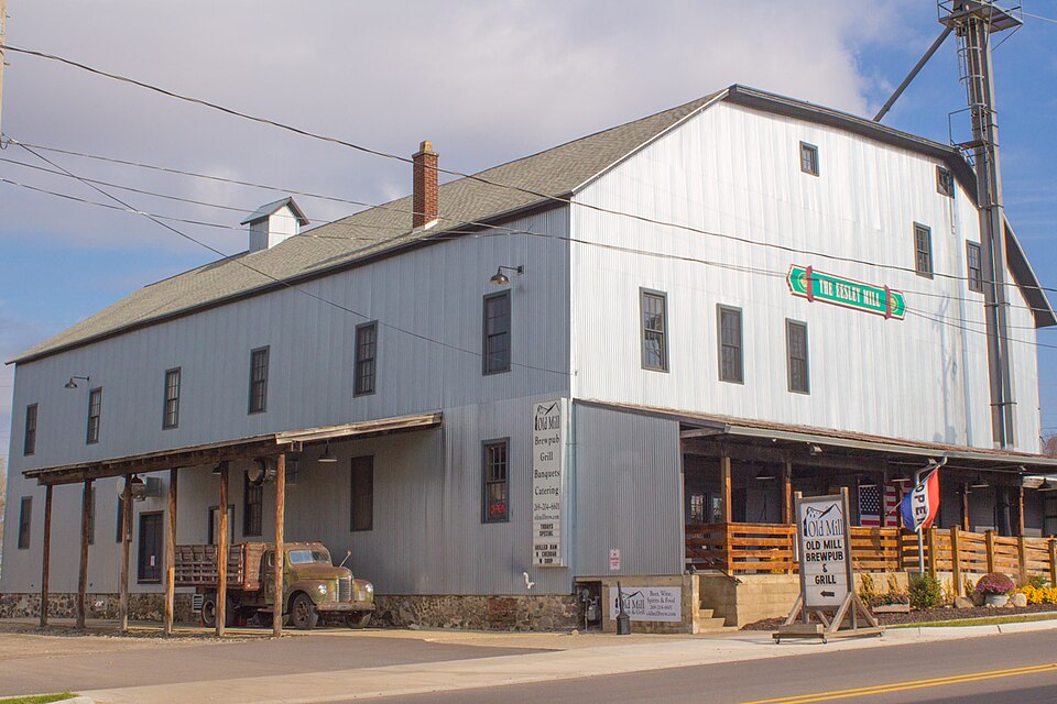
Photograph of J. F. Eesley Milling Co. Flour Mill-Elevator
Photograph by rossograph, CC BY-SA 3.0. Via Wikimedia Commons.

J. F. Eesley Milling Co. Flour Mill-Elevator

Built in 1870. Listed on the National Register of Historic Places in 1991.

From the record

One of 33 National Register listings published here for Allegan County · listed in 1991 · category: Structure · built in 1870.

Sources: the case file at the National Archives · the National Register database, National Park Service · the Wikipedia article

The listing

  • What is counted as historic. The nomination lists 1 building, 1 structure as contributing to the listing.
  • Listed as. Eesley, J. F., Milling Co. Flour Mill--Elevator - the National Register files a house under its owner's surname.
  • Address. 717 E. Bridge St., Plainwell, 49080
  • When was it listed? November 1991
  • Category. structure
  • Also known as. Plainwell MPS
  • City. Plainwell city
  • When was it built? 1870
  • National Register reference number. 91001547 - the number the National Park Service assigned this property when it was listed, and the key its nomination file is catalogued under at the National Archives.

The ground it stands on

1,188 words

The chapter on Plainwell City in History of Allegan and Barry Counties Michigan 1880, published 1880 names Plainwell. This is what it says, exactly as the scans read.

The village of Plainwell, an incorporated municipality of about 1650 inhabitants, is pleasantly situated on both banks of the Kalamazoo River. It is also a station of importance on the lines of the Grand Rapids and Indiana and the Kalamazoo division of the Lake-Shore and Michigan Southern Railroads, which roads here cross each other. By rail it is distant 12 miles from Kalamazoo, 36 miles from Grand Rapids, and 13 miles from Allegan, the countyseat.

Passage source: History of Allegan and Barry Counties Michigan 1880, published 1880.

Plainwell is a village of comparatively recent origin and growth, yet, lying in the midst of a district rich in agricultural resources, the seat of busy mills and manufactories, and the home of a thrifty, energetic people, it is deserving of more than mere mention in the history of Allegan County. Among the original owners of the lands within or near its present corporate limits were Norman Davis, Thomas J. Warner, Sylvester Sibley,t Lebbeus Sherwood, Thomas M. Warrant, Lucius Lindsley, Samuel Foster, Joseph D. Beers, Samuel Sherwood, Hull Sherwood, James Hanmer, and Sarah R. Hoskins,

Passage source: History of Allegan and Barry Counties Michigan 1880, published 1880.

Machine-read from a century-old scan, so expect the errors a machine makes: misspelled names, dropped words, stray characters.

Read the whole chapter on Plainwell City - 1,188 words on its settlement, mills, schools and churches.

Fires near this property

20 since 1993

Regional context, not property-specific evidence. The federal wildfire occurrence database lists 20 fires within 5 miles of J. F. Eesley Milling Co. Flour Mill-Elevator between 1993 and 2020, burning about 32 acres in total. 1 started naturally. None was recorded as arson. Distance is straight-line from the map coordinates, so a fire counted here may appear on a neighbouring settlement's page as well.

Reported cause Fires
Equipment and vehicle use9
Missing data/not specified/undetermined7
Debris and open burning3
Natural1

The most recent of them, most recent first, with the day each was reported and the service that recorded it.

DateCause SizeReported by Name on the report
19 September 2018Missing data/not specified/undetermined1.0 acresMichigan Department of Natural ResourcesPLAINWELL DPS 0002076 - 2018
2 July 2020Equipment and vehicle use1.0 acresMichigan Department of Natural ResourcesOTSEGO FD 0443 - 2020
23 May 2020Missing data/not specified/undetermined1.0 acresMichigan Department of Natural ResourcesGUN PLAIN CHARTER TWP FD 0000072 - 2020
2 May 2018Missing data/not specified/undetermined1.0 acresMichigan Department of Natural ResourcesGUN PLAIN CHARTER TWP FD 0000049 - 2018
9 April 2019Equipment and vehicle use1.0 acresMichigan Department of Natural ResourcesOTSEGO FD 243 - 2019
29 April 2018Equipment and vehicle use1.0 acresMichigan Department of Natural ResourcesGUN PLAIN CHARTER TWP FD 0000047 - 2018
19 April 2018Equipment and vehicle use1.0 acresMichigan Department of Natural ResourcesGUN PLAIN CHARTER TWP FD 0000042 - 2018
31 March 1993Debris and open burning1.0 acresMichigan Department of Natural Resourcesnot named

Every fire recorded in Allegan County

Mines and quarries near this property

5 within 5 miles

Regional context, not property-specific evidence. The federal mineral resources record lists 5 workings within 5 miles of J. F. Eesley Milling Co. Flour Mill-Elevator: 2 producers, 2 past producers, 1 prospect. 2 still produce. What was taken out: Sand and Gravel, Construction, Clay. Distance is straight-line from the map coordinates, so a quarry counted here may appear on a neighbouring settlement's page as well.

Where SiteCommodity StatusRecorded
Cushman Bros Clay PitClayPast Producer
Allegan Co PitSand and Gravel, ConstructionProducer
American Aggregates Corp.Sand and Gravel, ConstructionProducer
Smith PitSand and Gravel, ConstructionPast Producer
W.Douglas Sand ExposureSand and Gravel, ConstructionProspect

Every working recorded in Allegan County

Storms near this property

21 since 1996

Regional context, not property-specific evidence. The National Weather Service names Plainwell, the town this property stands in, in 21 storm reports between 1996 and 2026: 12 thunderstorm wind, 7 hail, 1 flash flood, 1 tornado. No death or injury is recorded in these reports. Each account below is quoted exactly as the forecast office filed it, from the NOAA Storm Events Database, and each date opens the federal record of that event.

WhenEvent Place namedHarm What the report says
April 2020HailPlainwell$500,000Very large hail to two inches in diameter was reported near Plainwell.
April 2008Tornado (EF1)Plainwell$150,000A National Weather Service storm survey determined that damage in the vicinity of 388 3rd Street in the southeast corner of Allegan county was caused by a tornado. The tornado was rated an EF-1 on the Enhanced Fujita Damage Scale. The tornado touched down just southwest of the above address in Allegan county.||The tornado was on the ground for nearly five miles, and traveled to the northeast. It did significant damage to a horse barn, lifted a trailer adjacent to the barn, damaged gravel yard equipment, lofted a tank, and uprooted numerous large trees. Some trees were snapped off.||No one was injured. The damage was concentrated about four miles east of Plainwell and extended from the 300 block of 102nd Avenue to the northeast, crossing 106th Avenue in the 100 to 200 block section.
May 2000HailPlainwell$40,000no account filed
July 2014HailPlainwell$10,000A trained spotter measured golf ball sized hail near Allegan street in Cooper township.
May 1998Thunderstorm WindPlainwell$10,000Trees and power lines downed in Plainwell. Trees fell across the road on 11th Street and along 10th Street near the intersections with 107th and 112th Streets.
June 2006Thunderstorm WindPlainwell$5,000Two trees were blown down in Plainwell.
July 2002Thunderstorm WindPlainwell$5,000Several large maple trees had limbs of up to one foot in diameter blown down by thunderstorm wind gusts.
June 1998Thunderstorm WindPlainwell$2,500Trees and power lines downed in Doster, 5 miles northeast of Plainwell, near the Allegan-Barry County border.
June 1998Thunderstorm WindPlainwell$2,500Trees and power lines downed in the city of Plainwell.
August 2020Thunderstorm WindPlainwell$2,000There was isolated tree damage near Plainwell.
August 2001Thunderstorm WindPlainwell$1,000no account filed
April 2026Thunderstorm WindPlainwell-Several uprooted trees.
July 2014HailPlainwell-A trained spotter reported one inch diameter hail near Plainwell.
June 2010Thunderstorm WindPlainwell-Law enforcement reported that a tree and many power lines were blown down one mile north northeast of Plainwell.
July 2008HailPlainwell-A trained spotter reported seven eighths inch diameter hail.
September 2007HailPlainwell-A trained spotter reported dime to penny size hail .
June 1998Thunderstorm WindPlainwell-Amateur radio operators estimated wind gusts to 60 mph 3 miles west of Plainwell, in Otsego Township, at 12:40 am EDT, Friday, June 26th.
July 1998Flash FloodPlainwell-A trained spotter reported street flooding in the city of Plainwell, where 2.71 inches of rain had fallen in less than 2 hours. No injuries or property damage was reported.
July 1998Thunderstorm WindPlainwell-A trained spotter reported numerous trees downed near the U.S. Highway 131 and Michigan Highway 89 interchange. A damage estimate was not available.
October 2007HailPlainwell-no account filed
January 1996Thunderstorm WindPlainwell-no account filed

Every storm recorded in Allegan County

Map coverage status

No historic map-sheet match is published for this property yet. That does not mean no map exists. This record needs a coordinate-quality review before it can be joined to a sheet boundary. Browse the county's mapped places while that work is pending.

Listed places nearby

6 within 8 miles

Other National Register properties close enough to walk or drive between, ordered by distance from this one. Both positions come from the same geocoding pass that matched these properties to their map sheets.

Sources for this property

National Archives recordThe nomination case file for reference 91001547 in Record Group 79.
Wikipedia articleCommunity-written account of this property, licensed CC BY-SA.
Allegan CountyAll 33 listed properties in this county.

Provenance

  • Listing record. National Park Service National Register of Historic Places, listed-properties dataset, current to 2026-05-22.
  • Map join. Address geocoded through the United States Census geocoder, then tested against the published boundary of every sheet in the USGS Historical Topographic Map Collection.
  • How this page is made. Listing fields come from federal records; map-sheet coverage is a labelled coordinate-to-boundary calculation, not a source-field claim.
  • Wildfire. Short, Karen C. 2022. Spatial wildfire occurrence data for the United States, 1992-2020 [FPA_FOD_20221014]. 6th Edition. Fort Collins, CO: Forest Service Research Data Archive. https://doi.org/10.2737/RDS-2013-0009.6 Collected with United States Government funding and usable without additional permissions or fees.
  • Mines and quarries. USGS Mineral Resources Data System (MRDS) https://mrdata.usgs.gov/mrds/ A work of the United States government, no copyright under 17 U.S.C. 105.
  • Storms. NOAA National Centers for Environmental Information, Storm Events Database https://www.ncei.noaa.gov/stormevents/ A work of the United States government, no copyright under 17 U.S.C. 105. Narratives are quoted verbatim from the National Weather Service report and are not edited or summarised.