 Block
From the record
13 National Register listings published here.
Sources: the National Register database, National Park Service
99 topographic sheets cover 41 settlements here, and 13 properties are on the National Register of Historic Places.
13 National Register listings published here.
Sources: the National Register database, National Park Service
Every property in this county listed on the National Register of Historic Places, with the year it was listed and the federal nomination document.
| Photograph | Property | Type | Listed | Reference |
|---|---|---|---|---|
| Battle Point (21CA12) | district | 1990 | 90001144 | |
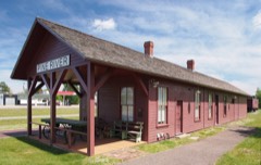 | Brainerd and Northern Minnesota-Minnesota and International Railway Depot | building | 2012 | 12000459 |
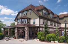 | Chase Hotel | building | 1980 | 80001994 |
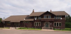 | Conservation Building | building | 2003 | 02001706 |
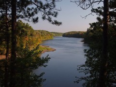 | Crow Wing State Park | site | 1970 | 70000288 |
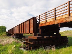 | Great Northern Railway Company Bridge | structure | 1980 | 80001990 |
| Hackensack Conservation Building | building | 2023 | 100009470 | |
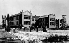 | Minnesota State Sanatorium for Consumptives | district | 2001 | 01000766 |
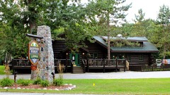 | Sherwood Forest Lodge Complex | building | 1980 | 80001992 |
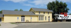 | Soo Line Depot | building | 1980 | 80001993 |
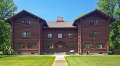 | Supervisor's Office Headquarters | building | 1976 | 76001049 |
| United States Forest Service, Remer District Ranger Station | building | 2023 | 100009469 | |
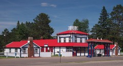 | Winnibigoshish Resort | building | 1980 | 80001989 |
Every wildfire the federal occurrence database records inside this county: 2,319 of them, burning about 12,990 acres. 32 started naturally and 515 were recorded as arson. Each settlement page carries the fires within five miles of it.
| Reported cause | Fires |
|---|---|
| Debris and open burning | 905 |
| Arson/incendiarism | 515 |
| Missing data/not specified/undetermined | 340 |
| Equipment and vehicle use | 192 |
| Recreation and ceremony | 139 |
| Misuse of fire by a minor | 62 |
| Power generation/transmission/distribution | 47 |
| Smoking | 34 |
| Natural | 32 |
| Railroad operations and maintenance | 24 |
| Other causes | 17 |
| Fireworks | 12 |
The five largest, by the area the report gives. 6 of them were set deliberately.
| Date | Cause | Size | Reported by | Name on the report |
|---|---|---|---|---|
| 5 May 1996 | Arson/incendiarism | 1,242 acres | Chippewa National Forest | BOY RIVER |
| 15 March 2012 | Debris and open burning | 393 acres | Minnesota Department of Natural Resources | not named |
| 31 March 2003 | Arson/incendiarism | 360 acres | Minnesota Department of Natural Resources | not named |
| 4 May 1996 | Arson/incendiarism | 360 acres | Chippewa National Forest | FED DAM WEST |
| 3 May 1996 | Debris and open burning | 342 acres | Minnesota Department of Natural Resources | not named |
| 11 October 1992 | Arson/incendiarism | 342 acres | Minnesota Department of Natural Resources | not named |
| 29 March 2016 | Arson/incendiarism | 332 acres | Minnesota Department of Natural Resources | not named |
| 23 March 2003 | Arson/incendiarism | 329 acres | Chippewa National Forest | BOY RIVER #8 |
Every settlement page carries the fires within five miles of it - see the settlement index below.
The NOAA Storm Events Database holds 557 reports for this county, causing 14 deaths, 79 injuries and about $10,928,000 in recorded property damage. Each settlement page carries the reports that name it.
| Kind of event | Reports |
|---|---|
| Hail | 263 |
| Thunderstorm Wind | 255 |
| Tornado | 28 |
| Lightning | 4 |
| Flash Flood | 3 |
| Funnel Cloud | 2 |
| Waterspout | 1 |
| Flood | 1 |
The most serious of them, by death, then injury, then recorded damage. The accounts are quoted exactly as the forecast office filed them.
| When | Event | Place named | Harm | What the report says |
|---|---|---|---|---|
| August 1969 | Tornado (F4) | not stated | 12 killed, 70 hurt, $2,500,000 | no account filed |
| August 2000 | Thunderstorm Wind | Outing | 1 killed | A 51 year old male scout leader was killed when a tree fell on a tent he was in near Lake Washburn. |
| July 1991 | Tornado (F1) | not stated | 1 killed | no account filed |
| August 1969 | Tornado (F3) | not stated | 4 hurt, $2,500,000 | no account filed |
| June 2016 | Lightning | Pontoria | 3 hurt | Three fishermen were injured when struck by lightning while on Baby Lake in rural Hackensack. The father and two sons had been fishing from a boat. The father, a 48 year-old, took a direct hit of lightning and was in serious condition with significant burns on his body. His two sons were treated at a local hospital and released. |
| July 1976 | Tornado (F1) | not stated | 1 hurt, $25,000 | no account filed |
| June 2018 | Lightning | Gull Lake | 1 hurt | Lightning struck a cabin just north of the Brainerd International Raceway. It went through the roof and struck a 15 year-old boy who was lying in bed before passing through the boxspring of the bed and exiting the cabin through an electrical outlet. The boy received superficial injuries. The bed he was on started on fire and there was damage to the electrical system of the cabin and an air conditioner. |
| August 1981 | Tornado (F1) | not stated | $2,500,000 | no account filed |
| August 1977 | Tornado (F3) | not stated | $2,500,000 | no account filed |
| June 2012 | Flood | Longville | $300,000 | Numerous roads were washed out due to flooding of streams due to heavy rain of 3 to 5 inches that fell June 19th and 20th. The worse area was from Longville to Remer and points east. |
| July 2015 | Lightning | Chickamaw Beach | $155,000 | Lightning struck a house east of Pine River, MN the morning of July 28th. The lightning caused extensive damage. It hit three large white pines and the house. It scorched outlets and wires, and blew out sheet rock and light fixtures. There was also some fire damage. |
| May 2022 | Tornado (EF1) | Esterday | $150,000 | The tornado crossed into Cass County from Wadena County along County Road 30 just south of 84th Street Southwest and tracked northeast for about half a mile before lifting just after crossing 84th Street Southwest. The tornado blew a center pivot irrigation system across 84th Street Southwest, snapping power poles in the process. No other damage was observed. The time of the tornado was estimated by radar and peak winds were around 100 mph. |
| April 2025 | Lightning | Lake Shr | $100,000 | A positive bolt of lightning struck a large red pine tree on a cul-de-sac on the south side of Loon Lake just southeast of the town of Pequot Lakes. The bolt caused extensive damage to one of the homes on the cul-de-sac including blowing out two well systems, burning the electric lines into the home, damaged a water line along with a water heater and water softener, blew off multiple tongue and groove boards, insulation and soffit on the house and a shed, destroyed internet and phone lines and all equipment connected to it, and had several wires burn and melt, leading to a smoky haze in the home. All of the homes on the cul-de-sac had some degree of damage, ranging from blown outlets to warped soffit pieces to blown out wells. |
| May 2022 | Thunderstorm Wind | Backus | $50,000 | Extensive damage was reported to several farms and homes in the area. |
| August 1977 | Tornado (F2) | not stated | $25,000 | no account filed |
| July 1975 | Tornado (F1) | not stated | $25,000 | no account filed |
| July 1968 | Tornado (F0) | not stated | $25,000 | no account filed |
| June 1967 | Tornado (F1) | not stated | $25,000 | no account filed |
| June 2010 | Hail | Bena | $15,000 | Most of the hail that fell was golf ball size. A few larger stones up to baseball size were observed. The hail was reported at the new Leech Lake Campground. There was hail damage to vehicles, awnings, and buildings in Bena. |
| June 2010 | Thunderstorm Wind | Bena | $15,000 | Substantial wind damage was reported. The wind blew hard enough to blow water through seals around windows of the campground lodge. A 100 pound access cover on the roof was thrown the entire length of the roof. Siding and shingles were damaged and thrown about. Covers were taken off the boat lift. Trees were downed, and a few were uprooted and sheared off. |
| July 2010 | Thunderstorm Wind | Pillager | $8,000 | Many trees were blown down, and power outages occurred. Some shingles were blown off a roof. |
| August 1982 | Tornado (F1) | not stated | $2,500 | no account filed |
| September 1964 | Tornado (F1) | not stated | $2,500 | no account filed |
| June 2010 | Tornado (EF0) | Poplar | $2,000 | The tornado continued from Wadena County. Trees were snapped along its path, including County Road 2 and 64 up to the west side of Deer Lake. |
| August 2010 | Thunderstorm Wind | Pine River | $1,500 | Several people reported trees down. |
| June 2010 | Thunderstorm Wind | Bena | $1,000 | Tree limbs were blown down due to the strong winds. |
| July 1978 | Tornado (F0) | not stated | $250 | no account filed |
| June 1971 | Tornado (F1) | not stated | $250 | no account filed |
| May 2025 | Thunderstorm Wind | Remer Muni Arpt | - | Two 20 inch diameter white spruce trees were snapped 4 to 6 feet off the ground by the winds. The downed trees then took down some nearby power lines. |
| June 2025 | Thunderstorm Wind | Cass Lake | - | A tree was down on camper at a campground. |
| June 2025 | Thunderstorm Wind | Cass Lake | - | A gust of 59 mph was recorded by Mesonet station CASM5 Cass Lake RAWS. |
| June 2025 | Thunderstorm Wind | Walker | - | Numerous trees were snapped and blown over. One tree was uprooted. |
| June 2025 | Thunderstorm Wind | Bena | - | One large tree was down along with many branches snapped off. |
| June 2025 | Tornado (EF1) | Pillager | - | First of two tornadoes from a severe thunderstorm that crossed through Cass and Crow Wing Counties. The tornado began just north of Casino, Minnesota, and moved northeasterly for about 3.75 miles before taking an easterly turn near the end of Home Brook Lane on the south end of Hardy Lake. It then traveled east-southeast for about 7 miles and crossed into Crow Wing County while over Gull Lake. The tornado continued into Crow Wing County for about three-quarters of a mile moving back on shore then dissipating after crossing Sea Gull Road NW at 1643 CDT. Damage along the path was mainly limited to hardwood and softwood trees that were snapped about 10 to 20 feet up (DI 27/28, DOD 4). Near the beginning of the tornado, it moved across a homestead causing roof damage to the attached garage of a home and pushed the entire unanchored garage structure about one foot (DI 1, DOD 4). |
| June 2025 | Thunderstorm Wind | Cass Lake | - | A large tree was uprooted at the Cass Lake rest area on US2. |
| July 2025 | Thunderstorm Wind | Walker | - | Tree and structure damage was reported in the city park. |
| July 2025 | Thunderstorm Wind | Walker | - | Damage was reported at the marina. |
| July 2025 | Thunderstorm Wind | Walker | - | A gust of 64 mph was recorded by the Walker Ambient Weather Station on First Point Drive. |
| July 2025 | Thunderstorm Wind | Bena | - | Several large trees were snapped and large branches down. |
| July 2025 | Thunderstorm Wind | Gull Lake | - | A 5 to 6 foot section of a dock was pulled out of the water. A few 3 foot in diameter tree branches were down from trees due to strong thunderstorm winds as well. Winds were gusty for about 20 minutes. |
| July 2025 | Thunderstorm Wind | Ah Gwan Ching | - | Several branches larger than four inches in diameter were broken off. |
| July 2025 | Thunderstorm Wind | Brevik | - | A dozen large trees down on Highway 200 blocking at least one lane. One tree was down on Highway 8 just north of Highway 200. |
| September 2025 | Hail | Esterday | - | Hail was accumulating and looked like snow. |
| August 2024 | Thunderstorm Wind | Pontoria | - | A tree and several large branches were down at the spotter's location. |
| August 2024 | Hail | Backus | - | The hail for upwards of 10 to 15 minutes. |
| June 2024 | Thunderstorm Wind | Longville | - | A few trees 14 inches in diameter were snapped at the trunk in a concentrated area. |
| June 2024 | Thunderstorm Wind | Pine River | - | Several small to medium trees were reported down and were snapped near the base. |
| June 2024 | Flash Flood | Longville | - | Water was covering County Road 5 NW near the outboard motor shop. The water was over a feet deep being about halfway up car tires near the edge of the flooded roadway. |
| June 2024 | Thunderstorm Wind | Brevik | - | Widespread tree damage was reported with large white pine branches being tossed. |
| June 2024 | Thunderstorm Wind | Brevik | - | Several trees were snapped with one large pine at least several feet in diameter snapped near the ground. |
| June 2023 | Hail | Pine River Muni Arpt | - | Hail fell for up to 30 minutes. Most of the hail was around a half inch in size, but a few were up to the size of quarters. |
| July 2023 | Hail | Pillager | - | Some damage to vehicles was observed. |
| May 2022 | Thunderstorm Wind | Pine River | - | Multiple trees were down in the Pine River area. |
| May 2022 | Thunderstorm Wind | Hackensack | - | Several large pine trees were uprooted and knocked over. |
| May 2022 | Thunderstorm Wind | Pillager | - | A few trees were down across Minnesota Highway 210. |
| May 2022 | Thunderstorm Wind | Longville | - | Thunderstorm winds flipped over a dock on Little Boy Lake. |
| May 2022 | Thunderstorm Wind | Brevik | - | A photo was received of an estimated 10 to 12 inch diameter pine tree down. |
| May 2022 | Thunderstorm Wind | Inguadona | - | A few large trees were down in the area. |
| May 2022 | Thunderstorm Wind | Cass Lake | - | Photos were received from the Chippewa National Forest of numerous small to medium trees down over forest roads. |
| May 2022 | Thunderstorm Wind | Remer | - | Photos were received showing large trees snapped at the base with several down on power lines. |
The Survey's mineral resources record lists 14 workings inside this county. 5 still produce and 9 are closed or unrecorded. Each settlement page carries the workings within five miles of it.
| Commodity | Workings |
|---|---|
| Sand and Gravel, Construction | 7 |
| Limestone, General | 5 |
| Peat | 1 |
| Iron | 1 |
The least common of them first, because a county's hundredth gravel pit says nothing its first ten did not.
| Where | Site | Commodity | Status | Recorded |
|---|---|---|---|---|
| Cass County Peat Deposits | Peat | Occurrence | ||
| Utica Mine | Iron | Past Producer | Hematite, Magnetite | |
| Cass County Marl Beds No 1 | Limestone, General | Occurrence | ||
| Cass County Marl Beds No 2 | Limestone, General | Occurrence | ||
| Cass County Marl Beds No 3 | Limestone, General | Occurrence | ||
| Cass County Marl Beds No 4 | Limestone, General | Occurrence | ||
| Sorum Marl Pit | Limestone, General | Past Producer | Marl | |
| Dixon Pit | Sand and Gravel, Construction | Producer | ||
| Hopen Pit and Mill | Sand and Gravel, Construction | Producer | ||
| Sixth Lake Rd Pit and Mill | Sand and Gravel, Construction | Producer | ||
| Snyker Mill | Sand and Gravel, Construction | Producer | ||
| Snyker Pit | Sand and Gravel, Construction | Past Producer | ||
| Stark Pit | Sand and Gravel, Construction | Past Producer | ||
| Whitney Pit & Mill | Sand and Gravel, Construction | Producer |
Named settlements recorded in the Geographic Names Information System, each with the topographic sheets covering it. Villages, hamlets and abandoned places alike. Each is shown with the nearest named watercourse or landform and the survey quadrangle it falls on.
North Cass unorganized territory · 56633 · Pennington quadrangle
9 sheets, 1954 to 1996
North Cass unorganized territory · 56633 · Pike Bay quadrangle
9 sheets, 1954 to 1996
No longer a settlement
Wahnena unorganized territory · 56636 · Deer River quadrangle
9 sheets, 1954 to 1996
Inguadona township · 56655 · On Trelipe Creek · Longville quadrangle
10 sheets, 1953 to 1996
Pine River city · 56474 · On Behler Creek · Pine River quadrangle
10 sheets, 1953 to 1976
North Cass unorganized territory · 56626 · Portage Lake quadrangle
9 sheets, 1954 to 1996
Pine Lake township · 56484 · On Whipholt Creek · Whipholt quadrangle
9 sheets, 1954 to 1996
The vanished settlements of Cass County: the places named above that are no longer on the map.