 Block
From the record
17 National Register listings published here.
Sources: the National Register database, National Park Service
54 topographic sheets cover 22 settlements here, and 17 properties are on the National Register of Historic Places.
17 National Register listings published here.
Sources: the National Register database, National Park Service
Every property in this county listed on the National Register of Historic Places, with the year it was listed and the federal nomination document.
| Photograph | Property | Type | Listed | Reference |
|---|---|---|---|---|
 | Gustaf Anderson House | building | 1980 | 80002000 |
 | Angel's Hill Historic District | district | 1972 | 72000675 |
 | J. C. Carlson House | building | 1980 | 80002004 |
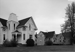 | Center City Historic District | district | 1980 | 80001996 |
 | John Daubney House | building | 1980 | 80002008 |
| Franconia Historic District | district | 1980 | 80000406 | |
 | Grant House | building | 1980 | 80002005 |
 | Interstate State Park CCC/WPA/Rustic Style Campground | district | 1992 | 92000638 |
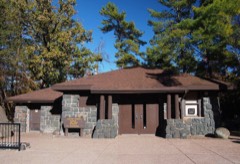 | Interstate State Park WPA/Rustic Style Historic District | district | 1992 | 89001664 |
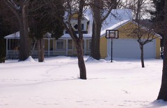 | Frank A. Larson House | building | 1980 | 80002001 |
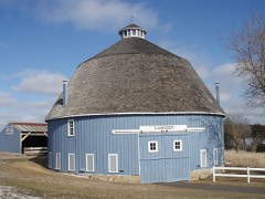 | Moody Barn | building | 1980 | 80001998 |
| Paul Munch House | building | 1976 | 76001050 | |
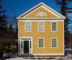 | Munch-Roos House | building | 1970 | 70000289 |
 | Point Douglas to Superior Military Road: Deer Creek Section | structure | 1991 | 90002200 |
 | Sayer House | building | 1980 | 80002002 |
 | Taylors Falls Public Library | building | 1970 | 70000290 |
 | Charles A. Victor House | building | 1980 | 80002003 |
Every wildfire the federal occurrence database records inside this county: 392 of them, burning about 1,354 acres. 3 started naturally and 52 were recorded as arson. Each settlement page carries the fires within five miles of it.
| Reported cause | Fires |
|---|---|
| Debris and open burning | 165 |
| Equipment and vehicle use | 65 |
| Missing data/not specified/undetermined | 61 |
| Arson/incendiarism | 52 |
| Recreation and ceremony | 27 |
| Smoking | 8 |
| Power generation/transmission/distribution | 4 |
| Fireworks | 3 |
| Natural | 3 |
| Railroad operations and maintenance | 3 |
| Misuse of fire by a minor | 1 |
The five largest, by the area the report gives. Two of them were set deliberately.
| Date | Cause | Size | Reported by | Name on the report |
|---|---|---|---|---|
| 26 April 2006 | Debris and open burning | 80 acres | Minnesota Department of Natural Resources | not named |
| 20 May 2009 | Equipment and vehicle use | 52 acres | Minnesota Department of Natural Resources | not named |
| 16 April 2019 | Missing data/not specified/undetermined | 45 acres | Minnesota Department of Natural Resources | not named |
| 14 February 2002 | Missing data/not specified/undetermined | 42 acres | Minnesota Department of Natural Resources | not named |
| 19 October 2000 | Arson/incendiarism | 40 acres | Minnesota Department of Natural Resources | not named |
| 1 April 2000 | Arson/incendiarism | 40 acres | Minnesota Department of Natural Resources | not named |
| 11 April 2009 | Missing data/not specified/undetermined | 36 acres | Minnesota Department of Natural Resources | not named |
| 29 March 2010 | Missing data/not specified/undetermined | 27 acres | Minnesota Department of Natural Resources | not named |
Every settlement page carries the fires within five miles of it - see the settlement index below.
The NOAA Storm Events Database holds 214 reports for this county, causing no deaths, 2 injuries and about $7,178,500 in recorded property damage. Each settlement page carries the reports that name it.
| Kind of event | Reports |
|---|---|
| Thunderstorm Wind | 98 |
| Hail | 85 |
| Tornado | 19 |
| Funnel Cloud | 7 |
| Flash Flood | 3 |
| Heavy Rain | 2 |
The most serious of them, by death, then injury, then recorded damage. The accounts are quoted exactly as the forecast office filed them.
| When | Event | Place named | Harm | What the report says |
|---|---|---|---|---|
| May 1957 | Tornado (F4) | not stated | 2 hurt, $25,000 | no account filed |
| June 2007 | Hail | Harris | $2,000,000 | Widespread hail damage to houses, barns, outbuildings, vehicles, and crops. Hail size was estimated. Some hail did not melt until the next morning. |
| May 2001 | Hail | Wyoming | $2,000,000 | Numerous cars and structures damaged. |
| July 2019 | Tornado (EF1) | Lindstrom | $500,000 | This is the continuation path of the Washington County tornado that moved into Chisago County on 240th Street North, east of Morgan Avenue. This EF1 tornado continued for approximately another 3.8 miles before dissipating north of a farm that was damaged on 268th Street. Along the path in Chisago County, the tornado damaged a farm shed, uprooted numerous trees, damaged an outdoor wedding venue near Highway 25, and destroyed an outbuilding before dissipating. Maximum winds were estimated at 90 mph, with a width of 250 yards in Chisago County. |
| June 2003 | Thunderstorm Wind | Chisago City | $500,000 | Scattered trees toppled. |
| June 2001 | Hail | Rush City | $400,000 | Ninety percent of homes in town received damage. Hundreds of broken windows. Siding, roofs and vehicles damaged by wind driven hail. |
| July 2019 | Thunderstorm Wind | Rush Pt | $250,000 | The bow echo that moved across Pine County, continued to intensify. It moved from the northern part of Chisago County, southeast into Polk County in Wisconsin. The path of straight line winds was noted as it crossed interstate 35 where very large trees were uprooted or blown down. There was damage to barns, outbuildings and homes along the path. The Chisago County fair grounds was closed due to blown down trees and power lines in Rush City. |
| July 2011 | Thunderstorm Wind | Harris | $250,000 | Several trees were blown down in Harris, Minnesota. |
| July 2011 | Thunderstorm Wind | Stacy | $250,000 | Several trees were blown down in Stacy, Minnesota. |
| July 2011 | Thunderstorm Wind | Rush Pt | $250,000 | Numerous large trees were blown down around Rush City, Minnesota. In addition, residents reported heavy damage to homes in the northwestern part of Chisago County. |
| June 1954 | Tornado (F1) | not stated | $250,000 | no account filed |
| July 2020 | Thunderstorm Wind | Harris | $100,000 | A NWS Storm Survey determined that severe straight-line winds and occasional downburst winds, damaged hundreds of trees between Harris and Rush City along County Road 30. Some of the trees landed on vehicles, roofs and sheds. One machine shed had its roof blown off. |
| June 2013 | Tornado (EF0) | Wyoming | $100,000 | Dozens of trees were uprooted or snapped along a half mile long path around Ashton Lake in Wyoming. Some trees landed on houses, fences and sheds with the greatest damage on the northeast side of the lake. |
| September 2013 | Thunderstorm Wind | Rush Pt | $100,000 | Scattered large trees were blown down across the northern half of Chisago County, including a tree falling on a house west of Rush City. |
| August 2009 | Tornado (EF0) | North Branch | $100,000 | A National Weather Service Storm Survey determined that an EF-0 tornado tracked from near the North Branch Middle School, northwest to near Rivercrest and Riverview Courts in North Branch, Minnesota. Roof damage was indicated at the middle school, with a telephone pole snapped, and major trees blown down in the residential area. Based on roof damage and trees blown down, winds were estimated at 70 to 80 mph. |
| June 2001 | Thunderstorm Wind | Rush City | $60,000 | Roof ripped off pole barn. Siding torn from garage, and then blown onto truck. Trees toppled on to two pickup trucks. |
| July 1966 | Tornado (F0) | not stated | $25,000 | no account filed |
| August 2009 | Thunderstorm Wind | Wyoming | $15,000 | A local resident in Wyoming, Minnesota reported numerous trees blown down, a portion of their porch supporting beam destroyed and a shop garage door blown away. |
| May 1962 | Tornado (F1) | not stated | $2,500 | no account filed |
| June 2015 | Thunderstorm Wind | Rush Pt | $1,000 | A tree was blown down in the Rush Lake area. Plus, sliding damage occurred due to the large hail and wind near Rush Lake. |
| June 2025 | Thunderstorm Wind | North Branch | - | Large tree was snapped near its base in North Branch. |
| June 2025 | Thunderstorm Wind | North Branch | - | A large tree snapped near its base in North Branch. |
| May 2024 | Hail | Almelund | - | The hail damaged garage doors and the roof of a camper. |
| May 2024 | Thunderstorm Wind | Almelund | - | A few trees were downed near Almelund. |
| August 2024 | Thunderstorm Wind | Stacy | - | Report of multiple trees down. |
| August 2024 | Thunderstorm Wind | North Branch | - | Multiple trees reported down. |
| September 2024 | Thunderstorm Wind | Wyoming | - | Some trees were blown down. |
| September 2024 | Thunderstorm Wind | Center City | - | Some trees were blown down. |
| June 2023 | Thunderstorm Wind | North Branch | - | A Hennepin County Emergency Management Meteorologist forwarded multiple photos of trees down in the city of North Branch along Harder Parkway. |
| August 2023 | Thunderstorm Wind | Center City | - | There was a report of 4 to 6 inch branches and trees down in Center City. |
| July 2023 | Hail | Rush City Muni Arpt | - | Photo measurement provided via social media. |
| July 2023 | Thunderstorm Wind | Sunrise | - | Trees measuring 8 to 10-inch diameter and powerlines down across roadway, 3 miles east of Sunrise, MN or 7 miles NE of North Branch, MN. |
| July 2023 | Hail | Almelund | - | Delayed report of quarter to golfball size hail in Almelund Minnesota. |
| July 2023 | Thunderstorm Wind | Rush City Muni Arpt | - | Several trees down 2 miles ESE of Rush City, MN. |
| May 2022 | Thunderstorm Wind | Lindstrom | - | There was a social media picture of blown down power lines near Lindstrom. The emergency manager also reported several trees down in Lindstrom. |
| May 2022 | Thunderstorm Wind | Center City | - | A number of trees and power lines were downed, with some trees and large branches landing on houses. |
| May 2022 | Thunderstorm Wind | Shafer | - | Two buildings lost a portion of their roofs at a farm. About a dozen trees were tipped over. |
| May 2022 | Thunderstorm Wind | Stacy | - | A large tree blew down and it took down a power line near Stacy. |
| May 2022 | Thunderstorm Wind | Sunrise | - | There were a few trees uprooted east of Sunrise. |
| May 2022 | Thunderstorm Wind | Taylors Falls | - | Several dozen trees were uprooted or broken, with some landing on houses, sheds, and vehicles. |
| July 2020 | Thunderstorm Wind | Rush City | - | A few trees were blown down in Rush City, along Highway 61. |
| July 2020 | Tornado (EF0) | Rush Pt | - | A brief tornado cross the southern portion of West Rush Lake, uprooting trees and knocking down numerous large branches. It flipped several boat docks and pontoons. Some debris from the docks was blown 1/2 mile downwind into some trees. |
| June 2019 | Thunderstorm Wind | Rush City | - | A large tree was blown down near 525th and Fairfield Avenue in Rush City. |
| July 2019 | Thunderstorm Wind | Almelund | - | The Wild River State Park had damage throughout their park area. Numerous trees were blown down and blocked roads in and out of the park. |
| July 2017 | Tornado (EF0) | Lindstrom | - | A brief tornado hit three properties, knocking down dozens of trees and collapsing a barn. |
| July 2017 | Tornado (EF0) | Wyoming | - | After exiting Anoka County, the tornado clipped the southwest part of Chisago County, downing over 100 trees. The tornado did take some tin off the roof of a shed. It dissipated just before reaching Washington County, where the collapsing storm produced widespread downburst damage in and around Forest Lake. |
| June 2016 | Thunderstorm Wind | Harris | - | A few trees were blown down near Harris, along Falcon Drive at 425th St. |
| July 2016 | Thunderstorm Wind | Chisago City | - | Several large trees, up to 5 feet in diameter, were blown down south of Chisago Lakes and into Chisago Lakes Township. |
| July 2016 | Heavy Rain | Chisago City | - | A trained spotter measured 3.07 inches of rain south of Chisago City. |
| July 2016 | Thunderstorm Wind | Stark | - | Several trees were blown down in North Branch. |
| June 2015 | Hail | Rush Pt | - | Several reports of large hail occurred around Rush Lake, and Rush City. The largest hail stone was 3 inches in diameter. |
| June 2015 | Hail | Wyoming | - | Several reports of large hail occurred at and near Wyoming to Chisago City in southern Chisago County. The largest hail stone was quarter size. |
| June 2015 | Hail | North Branch | - | Several reports of large hail occurred around the city of North Branch. The largest hail stone was tennis ball size. |
| July 2015 | Thunderstorm Wind | North Branch | - | A few trees were blown down near North Branch. |
| July 2015 | Thunderstorm Wind | Almelund | - | A few trees were blown down in Amador Township, near Almelund. |
| July 2015 | Thunderstorm Wind | Rush City Muni Arpt | - | Several trees and power lines were blown down in Rushseba Township, northeast of Rush City. |
| June 2013 | Heavy Rain | Stacy | - | Storm total rainfall amount of 2.46 inches was measured near Stacy. |
| August 2012 | Thunderstorm Wind | Lindstrom | - | Several large tree limbs were blown down. |
| August 2011 | Thunderstorm Wind | North Branch | - | Numerous trees were blown down near North Branch. |
| July 2011 | Thunderstorm Wind | Almelund | - | About 20 trees were downed, and half of a roof was torn off a horse stable. |
The Survey's mineral resources record lists 3 workings inside this county. All of them still produce. Each settlement page carries the workings within five miles of it.
| Commodity | Workings |
|---|---|
| Sand and Gravel, Construction | 3 |
The least common of them first, because a county's hundredth gravel pit says nothing its first ten did not.
| Where | Site | Commodity | Status | Recorded |
|---|---|---|---|---|
| E F Hals Sand & Gravel Pit | Sand and Gravel, Construction | Producer | ||
| Herberg Pit and Mill | Sand and Gravel, Construction | Producer | ||
| Succo Pit and Mill | Sand and Gravel, Construction | Producer |
Named settlements recorded in the Geographic Names Information System, each with the topographic sheets covering it. Villages, hamlets and abandoned places alike. Each is shown with the nearest named watercourse or landform and the survey quadrangle it falls on.
Franconia township · 55074 · On Lawrence Creek · Osceola quadrangle
24 sheets, 1900 to 1985
Taylors Falls city · 55084 · Near Saint Croix Dalles · Saint Croix Dalles quadrangle
23 sheets, 1900 to 1985