 Block
From the record
2 National Register listings published here.
Sources: the National Register database, National Park Service
30 topographic sheets cover 23 settlements here, and 2 properties are on the National Register of Historic Places.
2 National Register listings published here.
Sources: the National Register database, National Park Service
Every property in this county listed on the National Register of Historic Places, with the year it was listed and the federal nomination document.
| Photograph | Property | Type | Listed | Reference |
|---|---|---|---|---|
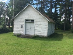 | Gran Evangelical Lutheran Church | building | 1988 | 88000593 |
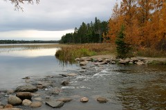 | Itasca State Park | district | 1973 | 73000972 |
Every wildfire the federal occurrence database records inside this county: 1,374 of them, burning about 102,618 acres. 8 started naturally and 492 were recorded as arson. Each settlement page carries the fires within five miles of it.
| Reported cause | Fires |
|---|---|
| Debris and open burning | 512 |
| Arson/incendiarism | 492 |
| Missing data/not specified/undetermined | 188 |
| Misuse of fire by a minor | 83 |
| Equipment and vehicle use | 54 |
| Recreation and ceremony | 16 |
| Natural | 8 |
| Smoking | 8 |
| Other causes | 4 |
| Railroad operations and maintenance | 4 |
| Power generation/transmission/distribution | 3 |
| Fireworks | 2 |
The five largest, by the area the report gives. None of them was recorded as arson.
| Date | Cause | Size | Reported by | Name on the report |
|---|---|---|---|---|
| 9 April 2003 | Debris and open burning | 19,782 acres | Red Lake Agency | RL304 |
| 15 May 2002 | Missing data/not specified/undetermined | 8,480 acres | Red Lake Agency | RL468 |
| 6 April 2002 | Missing data/not specified/undetermined | 7,455 acres | Red Lake Agency | RL13 |
| 17 March 2000 | Missing data/not specified/undetermined | 5,120 acres | Red Lake Agency | RL208 |
| 18 April 1994 | Missing data/not specified/undetermined | 4,200 acres | Red Lake Agency | not named |
| 6 April 2006 | Missing data/not specified/undetermined | 3,650 acres | Red Lake Agency | RED LAKE 16 |
| 9 April 1995 | Missing data/not specified/undetermined | 3,500 acres | Red Lake Agency | R92 |
| 18 March 2000 | Missing data/not specified/undetermined | 3,250 acres | Red Lake Agency | RL207 |
Every settlement page carries the fires within five miles of it - see the settlement index below.
The NOAA Storm Events Database holds 246 reports for this county, causing no deaths, 1 injury and about $3,515,230 in recorded property damage. Each settlement page carries the reports that name it.
| Kind of event | Reports |
|---|---|
| Hail | 121 |
| Thunderstorm Wind | 85 |
| Tornado | 21 |
| Flash Flood | 9 |
| Flood | 6 |
| Funnel Cloud | 3 |
| Lightning | 1 |
The most serious of them, by death, then injury, then recorded damage. The accounts are quoted exactly as the forecast office filed them.
| When | Event | Place named | Harm | What the report says |
|---|---|---|---|---|
| August 1985 | Thunderstorm Wind | not stated | 1 hurt | no account filed |
| July 2013 | Tornado (EF2) | Zerkel | $750,000 | This tornado began in Mahnomen County, just southeast of Mahnomen, at 12:50 am CST. The total tornado track was about 21 miles. The tornado damaged structures at three locations along the route with long tracks of tree and crop damage. Peak winds were estimated at 115 mph. |
| June 2025 | Thunderstorm Wind | Zerkel | $700,000 | Ground survey and high resolution satellite confirmed a long swath of widespread destructive straight-line winds estimated between 80 and 90 mph starting across south central Clearwater County north of Highway 200 and south of Highway 2. The swath was 8 miles at its widest and easternmost point in Clearwater County. This surge of straight-line winds continued east into southern Beltrami and northern Hubbard counties where more significant winds and impacts were observed around Bemidji. The 30 mile long swath started in Clearwater County and ended near the southeastern Beltrami county line. There was approximately 60,388 acres of Clearwater County impacted with widespread tree damage within this single swath. |
| June 2017 | Hail | Lake Itasca | $500,000 | The hail fell at Itasca State Park and was reported via social media. |
| June 2002 | Flash Flood | Clearbrook | $350,000 | Water flowed over streets and roads as 7 to 11 inches of rain fell. Most of the road damage occurred along Silver Creek. The city park and 3 homes were also flooded. Several roads were washed out in Itasca State Park. |
| July 2013 | Thunderstorm Wind | Berner | $300,000 | A downburst wind damage path developed across west central Greenwood Township. Numerous trees were toppled with some falling on the Greenwood Township Hall roof. A one to two mile wide swath of wind damage extended for over three miles and indicated peak winds of 60 to 80 mph. |
| July 2001 | Thunderstorm Wind | Gonvick | $250,000 | Trees were blown down on cars and powerlines. |
| June 1959 | Tornado (F1) | not stated | $250,000 | no account filed |
| June 2008 | Tornado (EF1) | Lake Itasca | $200,000 | This tornado originated in Becker County at 844 pm CDT. It travelled about 2 miles across extreme southeast Clearwater County to around 5 miles south-southeast of Lake Itasca by 854 pm CDT. From there it continued into Hubbard County. Several large trees were knocked down or uprooted along its path. Peak winds were estimated to 105 mph. |
| July 2013 | Tornado (EF1) | Berner | $50,000 | This tornado began in Polk County, about one mile north of Trail, at 12:33 am CST. The tornado snapped and uprooted numerous trees along its entire seven mile path. Peak winds were estimated at 90 mph. |
| May 1996 | Thunderstorm Wind | Bagley | $50,000 | no account filed |
| August 1960 | Tornado (F2) | not stated | $25,000 | no account filed |
| April 2022 | Flash Flood | Bagley | $20,000 | Highway 92 south of Highway 2 was closed off due to debris jams and flooding near the Clearwater River Bridge, and for a short distance upriver along the Clearwater River and the confluence of the Walker Brook. |
| June 2008 | Hail | Shevlin | $20,000 | The hail continued for about four minutes, or from 7:37 PM to 7:41 PM. |
| May 2003 | Tornado (F0) | Gonvick | $10,000 | A brief tornado touchdown caused minor tree damage and lifted shingles on several roofs. A tin building was lifted into the street, causing minor damage. |
| August 2001 | Thunderstorm Wind | Gonvick | $10,000 | A large tree was blown down and roof damage was reported to homes and businesses. |
| May 2013 | Flood | Berner | $5,000 | no account filed |
| April 2013 | Flood | Berner | $5,000 | no account filed |
| March 2009 | Flood | Berner | $5,000 | no account filed |
| July 1998 | Thunderstorm Wind | Lake Itasca | $3,000 | Trees were blown down at Lake Itasca. |
| August 1981 | Tornado (F2) | not stated | $2,500 | no account filed |
| August 2020 | Flash Flood | Shevlin | $2,000 | Fields and farm access roads were flooded across southeast Copley and southern Shevlin townships. Street flooding was reported in Shevlin. |
| April 2001 | Thunderstorm Wind | Bagley | $2,000 | A 60 mph wind gust blew down some small trees and a screened porch. |
| August 2001 | Thunderstorm Wind | Gonvick | $2,000 | Trees were blown down. |
| June 2023 | Flash Flood | Bagley | $1,000 | Law Enforcement reports flash flooding with a squad car under water. |
| August 2001 | Thunderstorm Wind | Clearbrook | $1,000 | Trees were blown down. |
| June 2023 | Flash Flood | Bagley Muni Arpt | $500 | Public reports a foot of standing water on HWY 92 S of Bagley. |
| August 2002 | Thunderstorm Wind | Lake Itasca | $500 | A large tree was blown down. |
| July 1999 | Thunderstorm Wind | Bagley | $500 | Trees were blown down. |
| June 1998 | Thunderstorm Wind | Bagley | $200 | The strong wind blew down large branches. |
| July 1979 | Tornado (F0) | not stated | $30 | no account filed |
| July 2025 | Thunderstorm Wind | Shevlin | - | Multiple trees down and broken tree branches in Shelvin, MN. Time estimated by radar. |
| June 2025 | Thunderstorm Wind | Zerkel | - | High resolution satellite imagery reveals numerous swaths of significant tree damage in portions of southern Clearwater County MN. This includes one noteworthy area of widespread tree destruction near Long Lost Lake, particularly south and east of the lake. Maximum wind estimated from numerous trees snapped at the trunk blown down in a unidirectional and divergent pattern indicative of destructive straight line winds around 100 mph. |
| June 2023 | Thunderstorm Wind | Bagley | - | Small tree downed in addition to pea-sized hail and very heavy rain. Time estimated from radar. |
| May 2023 | Hail | Ebro | - | Social media report of quarter-size hail. |
| May 2023 | Hail | Zerkel | - | Report of quarter sized hail relayed via Facebook. |
| August 2023 | Thunderstorm Wind | Clearbrook | - | Public reports medium-sized branches down and pea-sized hail 3 NE Clearbrook. Wind speed estimated. |
| July 2023 | Hail | Shevlin | - | Public reports quarter sized hail in Shevlin. |
| June 2022 | Thunderstorm Wind | Leonard | - | A few large trees were blown down in northern Sinclair Township. |
| June 2022 | Hail | Alida | - | Received a public report of quarter-sized hail. |
| May 2022 | Thunderstorm Wind | Berner | - | A few trees were blown down near Minnesota HWY 1 and BIA 19. Time estimated based on radar. |
| May 2022 | Thunderstorm Wind | Lake Itasca | - | Several pine and poplar trees were snapped or uprooted along CR2, from southeast Bear Creek Township into eastern Itasca Township. Time estimated based on radar and nearby wind sensor reports. |
| June 2022 | Thunderstorm Wind | Berner | - | Peak wind was measured at a personal weather station. Dime to quarter sized hail fell for a short period of time. |
| June 2022 | Thunderstorm Wind | Zerkel | - | Several pine and poplar trees were blown down along MN200. Time was estimated based on radar. |
| May 2022 | Hail | Berner | - | Received a report of quarter-sized hail and strong winds. |
| August 2020 | Hail | Zerkel | - | The hail fell along highway 113. |
| August 2020 | Hail | Lake Itasca | - | The hail fell near the main lodge. |
| August 2020 | Hail | Ebro | - | The hail fell near the Shooting Star Casino. |
| August 2020 | Thunderstorm Wind | Leonard | - | Multiple trees were blown down, one falling on a house. A garage and barn were also damaged. |
| July 2020 | Thunderstorm Wind | Clearbrook | - | A small tree was blown down in town. |
| July 2020 | Thunderstorm Wind | Alida | - | Numerous large branches were blown down. |
| September 2020 | Thunderstorm Wind | Leonard | - | Several tree branches were blown down. |
| June 2020 | Thunderstorm Wind | Berner | - | A few trees were snapped in a grove. |
| May 2019 | Thunderstorm Wind | Clearbrook | - | Very heavy rain and strong winds were reported along with pea to marble sized hail. |
| June 2019 | Hail | Berner | - | Large hail damaged crops across central Windsor Township. |
| June 2019 | Hail | Alida | - | Most of the hail was 0.25 to 0.50 inches in diameter. |
| August 2019 | Thunderstorm Wind | Alida | - | Large tree limbs were blown down. |
| July 2019 | Thunderstorm Wind | Gonvick | - | Several large branches were blown down. |
| July 2019 | Thunderstorm Wind | Zerkel | - | Large tree branches were blown down. |
| July 2018 | Hail | Bagley | - | The hail fell with very heavy rain. |
The Survey's mineral resources record lists 16 workings inside this county. 14 still produce and 2 are closed or unrecorded. Each settlement page carries the workings within five miles of it.
| Commodity | Workings |
|---|---|
| Sand and Gravel, Construction | 14 |
| Limestone, General | 2 |
The least common of them first, because a county's hundredth gravel pit says nothing its first ten did not.
| Where | Site | Commodity | Status | Recorded |
|---|---|---|---|---|
| Clearwater County Marl Beds No 1 | Limestone, General | Occurrence | ||
| Clearwater County Marl Beds No 2 | Limestone, General | Occurrence | ||
| Anderson Pit | Sand and Gravel, Construction | Producer | ||
| Broin Pit | Sand and Gravel, Construction | Producer | ||
| Colstrom Pit | Sand and Gravel, Construction | Producer | ||
| Dahlke Pit | Sand and Gravel, Construction | Producer | ||
| Gesell East Mill | Sand and Gravel, Construction | Producer | ||
| Gesell No 2 East Pit | Sand and Gravel, Construction | Producer | ||
| Lavine Pit | Sand and Gravel, Construction | Producer | ||
| Mathison Pit | Sand and Gravel, Construction | Producer | ||
| Murray Pit | Sand and Gravel, Construction | Producer | ||
| North Pit and Mill | Sand and Gravel, Construction | Producer | ||
| Pawek Pit | Sand and Gravel, Construction | Producer | ||
| Spike Lake Pit & Mill | Sand and Gravel, Construction | Producer | ||
| Thompson Pit | Sand and Gravel, Construction | Producer | ||
| Thorson Pit | Sand and Gravel, Construction | Producer |
Named settlements recorded in the Geographic Names Information System, each with the topographic sheets covering it. Villages, hamlets and abandoned places alike. Each is shown with the nearest named watercourse or landform and the survey quadrangle it falls on.
La Prairie township · 56621 · On Auganaush Creek · Zerkel quadrangle
10 sheets, 1954 to 1985
La Prairie township · 56621 · On Mosquito Creek · Zerkel quadrangle
10 sheets, 1954 to 1985
La Prairie township · 56621 · On Buckboard Creek · Zerkel quadrangle
10 sheets, 1954 to 1985
Bear Creek township · 56676 · On Bear Creek · La Salle Lake quadrangle
9 sheets, 1954 to 1985
Itasca township · 56676 · On Sucker Creek · La Salle Lake quadrangle
9 sheets, 1954 to 1985
Itasca township · 56676 · Heart Lake quadrangle
10 sheets, 1954 to 1985
No longer a settlement
La Prairie township · 56621 · On Buckboard Creek · Zerkel quadrangle
10 sheets, 1954 to 1985
Winsor township · 56644 · On Silver Creek · Gully quadrangle
11 sheets, 1919 to 1985
No longer a settlement
The vanished settlements of Clearwater County: the places named above that are no longer on the map.