 Block
From the record
3 National Register listings published here.
Sources: the National Register database, National Park Service
46 topographic sheets cover 10 settlements here, and 3 properties are on the National Register of Historic Places.
3 National Register listings published here.
Sources: the National Register database, National Park Service
Every property in this county listed on the National Register of Historic Places, with the year it was listed and the federal nomination document.
| Photograph | Property | Type | Listed | Reference |
|---|---|---|---|---|
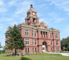 | Grant County Courthouse | building | 1985 | 85001945 |
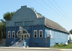 | Roosevelt Hall | building | 1985 | 85001819 |
 | Scofield, Anna J. Memorial Auditorium and Harold E. Thorson Memorial Library | building | 2015 | 15000212 |
Every wildfire the federal occurrence database records inside this county: 27 of them, burning about 1,536 acres. None started naturally and 2 were recorded as arson. Each settlement page carries the fires within five miles of it.
| Reported cause | Fires |
|---|---|
| Missing data/not specified/undetermined | 11 |
| Debris and open burning | 9 |
| Equipment and vehicle use | 3 |
| Arson/incendiarism | 2 |
| Other causes | 1 |
| Recreation and ceremony | 1 |
The five largest, by the area the report gives. One of them was set deliberately.
| Date | Cause | Size | Reported by | Name on the report |
|---|---|---|---|---|
| 1 April 2015 | Missing data/not specified/undetermined | 292 acres | Fergus Falls Wetland Management District | SPINK WF |
| 15 April 2009 | Debris and open burning | 288 acres | Minnesota Department of Natural Resources | not named |
| 26 April 2011 | Arson/incendiarism | 160 acres | Detroit Lakes Wetland Management District | SHAY |
| 6 May 2005 | Debris and open burning | 156 acres | Minnesota Department of Natural Resources | not named |
| 15 April 2009 | Missing data/not specified/undetermined | 130 acres | Fergus Falls Wetland Management District | HASEMAN WILDFIRE (110 FIRE) |
| 17 March 1995 | Equipment and vehicle use | 109 acres | Fergus Falls Wetland Management District | POMMEDETER |
| 30 April 2003 | Debris and open burning | 102 acres | Minnesota Department of Natural Resources | not named |
| 21 October 2000 | Equipment and vehicle use | 72 acres | Fergus Falls Wetland Management District | NORDBY |
Every settlement page carries the fires within five miles of it - see the settlement index below.
The NOAA Storm Events Database holds 309 reports for this county, causing no deaths, 1 injury and about $10,645,030 in recorded property damage. Each settlement page carries the reports that name it.
| Kind of event | Reports |
|---|---|
| Hail | 129 |
| Thunderstorm Wind | 109 |
| Tornado | 32 |
| Funnel Cloud | 16 |
| Flash Flood | 10 |
| Flood | 8 |
| Lightning | 4 |
| Heavy Rain | 1 |
The most serious of them, by death, then injury, then recorded damage. The accounts are quoted exactly as the forecast office filed them.
| When | Event | Place named | Harm | What the report says |
|---|---|---|---|---|
| June 2003 | Lightning | Barrett | 1 hurt, $10,000 | A 7 year-old girl was injured after lightning struck her family's home. The lightning hit a television antenna, cracked the ceiling, and burned a wall behind the girl. The strike also started a fire in the dining room. The girl suffered minor burns on her back and right shoulder. |
| April 1984 | Tornado (F2) | not stated | $2,500,000 | no account filed |
| May 1982 | Tornado (F3) | not stated | $2,500,000 | no account filed |
| May 2022 | Tornado (EF2) | Barrett | $2,000,000 | This tornado was wrapped in damaging downburst winds and rain as it rapidly tracked northeast for roughly 6 miles to around 3 SE of Elbow Lake by 419 pm CDT. Numerous wooden single and double X-Braced power poles were snapped, including a nearly 2-mile stretch of double pole structures along 240th street, as a broader downburst wind pattern developed. Numerous trees of all kinds were snapped or uprooted. Several farm buildings and grain bins were destroyed. Max winds to 120 mph, Max width to 350 yards. |
| May 2022 | Tornado (EF2) | Wendell | $1,000,000 | This tornado was wrapped in damaging downburst winds and rain as it rapidly tracked to the northeast for about 11 miles, ending around 4.3 miles NNE of Elbow Lake by 424 pm CDT. Numerous ash, spruce, cottonwood, and willow trees were snapped or uprooted. Numerous wooden power poles were snapped Numerous farm outbuilding and steel grain bins were destroyed, with roofing and wall panels carried downwind for a mile or more. Max winds were 115 mph, with a max width to 400 yards. |
| May 2022 | Thunderstorm Wind | Elbow Lake | $500,000 | Numerous large ash and spruce trees snapped or uprooted around town. One of 4 large 100k bushel steel grain bins was blown down at the Elbow Lake cooperative grain elevator. Wind gusts likely ranged from 70 to 90 mph for several seconds. Time estimated based on radar. The Elbow Lake wind sensor went offline due to widespread power outages. |
| May 2022 | Thunderstorm Wind | Elbow Lake | $500,000 | Numerous large ash and spruce trees snapped or uprooted at the Tipsinah Mounds Campground. Damaging downburst winds impacted much of Erdahl Township with wind gusts from 70 to 90 mph. Two storage building were blown down near the Tipsinah Mounds Golf Course. Report augmented by NWS damage survey. Time estimated based on radar. |
| June 2017 | Thunderstorm Wind | Ashby | $250,000 | Several semi-trucks were blown off Interstate 94 near Ashby. |
| June 1979 | Tornado (F1) | not stated | $250,000 | no account filed |
| August 1968 | Tornado (F1) | not stated | $250,000 | no account filed |
| July 2008 | Thunderstorm Wind | Hoffman | $150,000 | Roofs were lifted and torn off, which resulted in walls collapsing on two large hog finishing barns in southeast Land Township. The 800 hogs were not injured. |
| May 2022 | Thunderstorm Wind | Ashby | $120,000 | A semi tractor-trailer combination traveling on westbound I-94 was blown over onto an SUV that had parked on the shoulder of the highway due to an approaching storm. Reports indicate that three individuals were transported to a local hospital with non-life threatening injuries. Time estimated based on radar. |
| July 2020 | Thunderstorm Wind | Elbow Lake | $100,000 | A few large branches were blown down in shelterbelts across northern Pomme de Terre Township. |
| July 2020 | Tornado (EF4) | Ashby | $100,000 | This tornado began in Grant County, but after about two miles, it crossed into Otter Tail County, where it ended about 5 miles east of Dalton. The total track through both counties was about 9 miles. Peak winds were estimated at 170 mph, based on available damage indicators. At least 10 farmsteads were impacted, with three homes, one pole shed, and one machine shed destroyed. |
| June 1998 | Lightning | Ashby | $75,000 | The upper level of a house was lost due to a lightning fire. The downstairs was damaged by water that was used to fight the fire. The family escaped unharmed. |
| October 1997 | Thunderstorm Wind | Wendell | $50,000 | Two metal grain bins were blown across Highway 55 and into a field. Three others were blown into a shelterbelt. |
| March 2019 | Flood | Wendell | $50,000 | no account filed |
| July 1952 | Tornado (F1) | not stated | $25,000 | no account filed |
| July 2011 | Thunderstorm Wind | Wendell | $20,000 | A few large tree branches and tree limbs were broken down in farmsteads and shelterbelts across Lawrence and North Ottawa townships. |
| September 2007 | Lightning | Barrett | $20,000 | Lightning struck an evergreen tree in Barrett, scattering pieces of the tree across several neighboring yards. As the tree fell, it broke multiple windows and damaged the concrete steps to a house. The strike also damaged the electrical systems in three nearby homes. One home lost a microwave, two televisions, and several other smaller appliances. |
| July 1999 | Flood | Herman | $20,000 | 6 to 8 inches of rain fell across southern Grant county, with the town of Hoffman reporting 5 inches. Several roads were washed out and many others were blocked by high water. |
| May 1996 | Thunderstorm Wind | Pelican Lake | $20,000 | no account filed |
| June 1998 | Thunderstorm Wind | Hoffman | $15,000 | A cattle barn was damaged by the wind as well as trees and power lines. |
| July 1998 | Thunderstorm Wind | Wendell | $15,000 | A trailer home was flipped over in the strong wind at Lightning Lake. |
| July 2008 | Thunderstorm Wind | Wendell | $10,000 | Large tree limbs were blown down throughout the northwest portion of Grant County. |
| July 2008 | Thunderstorm Wind | Ashby | $10,000 | Several large tree limbs and tree tops were snapped off. |
| July 2004 | Thunderstorm Wind | Elbow Lake | $10,000 | A farm north of Elbow Lake was hit hard by the strong wind. An empty grain bin was pushed across a road and several others were damaged. A shed door was also pushed in by the wind. |
| July 2002 | Thunderstorm Wind | Herman | $10,000 | Strong winds hit a farmstead just south of Herman. A man who was in the house at the time said his ears popped. Ten to twelve trees were destroyed and some shingles on the house were lifted. A trampoline in the yard was twisted and the garage door was buckled. |
| July 1998 | Thunderstorm Wind | Ashby | $10,000 | Trees were blown down and a roof was blown off. |
| June 1997 | Thunderstorm Wind | Elbow Lake | $10,000 | Strong wind blew several trees over and took the roof off a barn. |
| June 1999 | Thunderstorm Wind | Barrett | $5,000 | Powerlines were blown down in the thunderstorm winds. |
| March 2009 | Flood | Wendell | $5,000 | no account filed |
| April 2009 | Flood | Wendell | $5,000 | no account filed |
| August 2008 | Hail | Wendell | $5,000 | no account filed |
| July 2008 | Thunderstorm Wind | Elbow Lake | $4,000 | Eight to ten inch diameter branches were blown down. |
| July 1998 | Thunderstorm Wind | Elbow Lake | $3,000 | Numerous trees around Elbow Lake were blown over in the strong wind. |
| August 1997 | Thunderstorm Wind | Hoffman | $3,000 | Wind blew down large trees and power poles in Hoffman and folded back the roof on a farm building. |
| May 1985 | Tornado (F0) | not stated | $2,500 | no account filed |
| September 1969 | Tornado (F1) | not stated | $2,500 | no account filed |
| August 2014 | Thunderstorm Wind | Herman | $2,000 | Several ten to twenty foot tall pine trees were blown over during a protracted period of heavy rain and strong gusty winds. |
| July 1999 | Thunderstorm Wind | Elbow Lake | $2,000 | Power poles were downed. |
| July 1998 | Thunderstorm Wind | Elbow Lake | $2,000 | Large trees were blown down. |
| July 2011 | Thunderstorm Wind | Wendell | $1,000 | A power pole was broken down by falling tree limbs, which caused widespread power outages in northwest Lawrence township. Wind driven hail also produced areas of crop damage. |
| August 2002 | Thunderstorm Wind | Ashby | $1,000 | Trees were blown down. |
| August 1999 | Lightning | Ashby | $1,000 | Lightning hit a huge cottonwood tree near a lake home on Pelican Lake. A piece of the tree slammed into a door, shattering the glass. |
| July 1998 | Thunderstorm Wind | Hoffman | $1,000 | A windmill was blown over in the strong wind. |
| July 1981 | Tornado (F0) | not stated | $30 | no account filed |
| August 2025 | Tornado (EFU) | Norcross | - | Relayed from emergency manager. Brief landspout type tornado northwest of Norcross. No damage reported. |
| August 2025 | Tornado (EFU) | Norcross | - | Relayed from emergency manager. Brief landspout type tornado west of Norcross. No damage reported. |
| July 2025 | Hail | Herman | - | Trained spotter reported ping pong ball size hail. |
| July 2025 | Thunderstorm Wind | Herman Muni Arpt | - | NDAWN station near Herman measured gust at 10m. |
| June 2025 | Thunderstorm Wind | Herman | - | Measured gust at MN DOT mesonet station MN131 Herman, MN. |
| June 2025 | Thunderstorm Wind | Herman | - | Ndawn mesonet observation. |
| June 2025 | Thunderstorm Wind | Herman | - | Ndawn mesonet observation. |
| June 2025 | Thunderstorm Wind | Barrett | - | Wind gust estimated by trained spotter. |
| July 2024 | Thunderstorm Wind | Herman | - | Crop damage from hail and wind around Herman, including striping of corn. Time estimated. |
| July 2024 | Hail | Hoffman | - | Public reports half dollar sized hail. |
| June 2024 | Thunderstorm Wind | Hoffman | - | Pictures relayed of tree damage due to high winds. |
| May 2023 | Hail | Wendell | - | Grant county FD reports quarter-size hail. |
| July 2023 | Hail | Hoffman | - | Golf ball sized hail reported by a Grant county Deputy, relayed by dispatch. |
The Survey's mineral resources record lists 1 working inside this county. It still produces. Each settlement page carries the workings within five miles of it.
| Commodity | Workings |
|---|---|
| Sand and Gravel, Construction | 1 |
The least common of them first, because a county's hundredth gravel pit says nothing its first ten did not.
| Where | Site | Commodity | Status | Recorded |
|---|---|---|---|---|
| Hanson Pit | Sand and Gravel, Construction | Producer |
Named settlements recorded in the Geographic Names Information System, each with the topographic sheets covering it. Villages, hamlets and abandoned places alike. Each is shown with the nearest named watercourse or landform and the survey quadrangle it falls on.
Elbow Lake township · 56590 · Stony Lake quadrangle
9 sheets, 1910 to 1989
No longer a settlement
Sanford township · 56531 · Elbow Lake quadrangle
10 sheets, 1911 to 1986
No longer a settlement
The vanished settlements of Grant County: the places named above that are no longer on the map.