 Block
From the record
4 National Register listings published here.
Sources: the National Register database, National Park Service
46 topographic sheets cover 21 settlements here, and 4 properties are on the National Register of Historic Places.
4 National Register listings published here.
Sources: the National Register database, National Park Service
Every property in this county listed on the National Register of Historic Places, with the year it was listed and the federal nomination document.
| Photograph | Property | Type | Listed | Reference |
|---|---|---|---|---|
| Consolidated School District No. 22 | building | 2017 | 100000565 | |
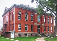 | Hubbard County Courthouse | building | 1984 | 84001475 |
| Louis J. Moser House | building | 1979 | 79001250 | |
 | Park Rapids Jail | building | 1988 | 88002053 |
Every wildfire the federal occurrence database records inside this county: 758 of them, burning about 2,957 acres. 11 started naturally and 90 were recorded as arson. Each settlement page carries the fires within five miles of it.
| Reported cause | Fires |
|---|---|
| Debris and open burning | 335 |
| Missing data/not specified/undetermined | 123 |
| Equipment and vehicle use | 109 |
| Arson/incendiarism | 90 |
| Recreation and ceremony | 36 |
| Smoking | 22 |
| Power generation/transmission/distribution | 16 |
| Natural | 11 |
| Fireworks | 4 |
| Other causes | 4 |
| Misuse of fire by a minor | 4 |
| Railroad operations and maintenance | 4 |
The five largest, by the area the report gives. One of them was set deliberately.
| Date | Cause | Size | Reported by | Name on the report |
|---|---|---|---|---|
| 5 May 2016 | Missing data/not specified/undetermined | 350 acres | Minnesota Department of Natural Resources | not named |
| 7 May 1992 | Recreation and ceremony | 178 acres | Minnesota Department of Natural Resources | not named |
| 6 April 2004 | Debris and open burning | 95 acres | Minnesota Department of Natural Resources | not named |
| 28 March 2015 | Missing data/not specified/undetermined | 89 acres | Minnesota Department of Natural Resources | not named |
| 23 April 1998 | Arson/incendiarism | 71 acres | Minnesota Agency | NO NAME |
| 18 May 2007 | Missing data/not specified/undetermined | 66 acres | Minnesota Department of Natural Resources | WHITE OAK |
| 17 April 2015 | Debris and open burning | 56 acres | Minnesota Department of Natural Resources | not named |
| 13 April 2015 | Missing data/not specified/undetermined | 55 acres | Minnesota Department of Natural Resources | not named |
Every settlement page carries the fires within five miles of it - see the settlement index below.
The NOAA Storm Events Database holds 356 reports for this county, causing no deaths, 5 injuries and about $9,939,430 in recorded property damage. Each settlement page carries the reports that name it.
| Kind of event | Reports |
|---|---|
| Hail | 169 |
| Thunderstorm Wind | 143 |
| Tornado | 23 |
| Funnel Cloud | 10 |
| Flash Flood | 5 |
| Lightning | 4 |
| Flood | 2 |
The most serious of them, by death, then injury, then recorded damage. The accounts are quoted exactly as the forecast office filed them.
| When | Event | Place named | Harm | What the report says |
|---|---|---|---|---|
| June 1997 | Thunderstorm Wind | Laporte | 2 hurt, $10,000 | Strong winds flipped a car over. |
| June 2008 | Tornado (EF2) | Hubbard | 1 hurt, $5,000,000 | This tornado originated in Wadena County, 1 mile east of Menagha, at 914 am CDT. It continued north-northeast where it crossed Hinds Lakes and passed along the east edge of Park Rapids. It lifted about 3 miles northeast of Park Rapids by 934 am CDT. Maximum tornado width was about 450 yards with peak winds of 130 mph. The tornado destroyed one home and hundreds of acres of forest. Several homes and businesses from Hinds Lake to Park Rapids received damage. |
| June 2002 | Tornado (F1) | Akeley | 1 hurt, $250,000 | 8 trees were uprooted and 3 recreational vehicles were demolished by falling trees. One man received a bruise on his head. |
| October 1997 | Thunderstorm Wind | Nevis | 1 hurt, $70,000 | A large recreational vehicle was overturned a complete revolution in the wind with 2 people inside. The woman sustained a cut on her head. |
| July 2008 | Thunderstorm Wind | Nevis | $750,000 | Several large trees were blown down, which blocked highway 13. Power lines and power poles were also blown down. Boats and docks received damage on area lakes. |
| May 2011 | Tornado (EF1) | Park Rapids | $600,000 | This tornado tracked for about six miles and was likely enshrouded in downburst winds and heavy rain along much of its path. Several sections of center pivot irrigation systems were flipped. Numerous large trees were uprooted or snapped and shingles and roofing materials were scattered about. Peak winds were estimated at 105 mph. |
| June 2025 | Thunderstorm Wind | Becida | $500,000 | Ground survey and high resolution satellite confirmed a long swath of widespread destructive straight-line winds estimated between 80 and 90 mph across far northern Hubbard County. The surge of winds and associated 30 mile long damage swath started upstream in Clearwater County and spread across southern Beltrami and northern Hubbard county. The widest part of the swath was almost 12 miles wide from just north of Bemidji to its southern edge in northern Hubbard county. The highest winds and greatest damage were in the Bemidji area. There was approximately 53,609 acres of northern Hubbard County impacted with widespread tree damage within this single swath. |
| June 2008 | Tornado (EF1) | Lake George | $400,000 | A tornado tracked to the north-northeast for nearly 3 miles and lifted about 1 mile east-southeast of Lake George by 1003 am CDT. Numerous large trees were knocked down or uprooted across Schoolcraft Lake Road and along county road 4. Peak wind speeds were estimated at 105 mph with a maximum width of 150 yards. |
| September 2014 | Lightning | Dorset | $300,000 | Lightning ignited a fire that destroyed one restaurant and badly damaged a second neighboring restaurant. |
| June 2008 | Tornado (EF1) | Nevis | $300,000 | A tornado tracked for about 1.5 miles to around 2 miles southeast of Nevis by 717 pm CDT. Several large trees were uprooted or knocked down along a path which crossed county road 13 south of state highway 34. Peak winds were estimated to 90 mph. |
| June 2008 | Tornado (EF1) | Lake George | $300,000 | This tornado originated in Becker County at 844 pm CDT and then crossed extreme southeast Clearwater County before entering Hubbard County. It travelled for an additional 3 miles into Hubbard County before lifting about 6 miles west of Lake George by 9 pm CDT. The total track length was nearly 8 miles. Several large trees were snapped off or uprooted near U.S. Highway 71. Peak winds were estimated to 105 mph. |
| July 2008 | Thunderstorm Wind | Park Rapids | $250,000 | Several large trees were blown down between Fish Hook and Potato Lakes. Some homes nearby received shingle damage. Boats and docks were blown about on area lakes. |
| June 2017 | Thunderstorm Wind | Benedict | $200,000 | Numerous trees were blown down around Kabekona Lake and across southern Lakeport Township. Peak winds were estimated from 85 to 95 mph. |
| June 2008 | Tornado (EF1) | Badoura | $200,000 | Three to four acres of downed timber was reported by a Minnesota DNR overflight. The tornado tracked about one-half mile to 4 miles south-southeast of Chamberlain by 1045 am CDT. The maximum width was 30 yards with peak winds to 100 mph. |
| June 2017 | Tornado (EF1) | Benedict | $150,000 | A weak tornado tracked to the northeast through a tree line and farmstead. The tornado snapped or uprooted numerous oak and pine trees, blew in part of a wall on a barn, and tore the roof off of a pole shed. Peak winds were estimated at 105 mph. |
| July 2013 | Thunderstorm Wind | Chamberlain | $100,000 | Many trees were damaged and tin roof panels were peeled off of a shed. |
| July 2010 | Flash Flood | Lake George | $100,000 | Water rose over state highway 64 up to six inches deep in several locations. High water was also an issue around the Lake Emma area. |
| June 2008 | Tornado (EF0) | Dorset | $100,000 | This tornado resulted from a storm split near Big Sand Lake and tracked to the northeast for nearly 5 miles. It had several brief touchdowns before it lifted about 5 miles east-southeast of Emmaville and east of Mantrap Lake by 951 am CDT. No significant damage was reported or detected by aerial survey, though some tree branch damage was noted. Estimated maximum width was 75 yards with peak winds estimated to 80 mph. |
| July 1996 | Thunderstorm Wind | Park Rapids | $80,000 | no account filed |
| October 1997 | Thunderstorm Wind | Nevis | $50,000 | Three buildings at Nevis Lumber sustained damage. |
| June 2008 | Thunderstorm Wind | Becida | $30,000 | The wind knocked down six to eight inch diameter tree branches. |
| October 1997 | Thunderstorm Wind | Nevis | $30,000 | Many large trees were blown down around Nevis. One tree fell on a house. |
| June 2002 | Thunderstorm Wind | Lake George | $25,000 | Microburst winds estimated as high as 90 mph blew trees and power lines down near Lake Alice. Boats and docks were also tossed around by the waves. |
| July 1999 | Thunderstorm Wind | Akeley | $25,000 | Numerous trees were blown down at the Akeley campground. One fell on a car and another fell on a truck. |
| June 2008 | Thunderstorm Wind | Lake George | $20,000 | A few large branches were blown down. |
| June 2008 | Hail | Nevis | $20,000 | Dime to quarter size hail fell from 7:20 PM to 7:26 PM. |
| July 1999 | Thunderstorm Wind | Nevis | $15,000 | Numerous trees were blown down, also knocking down power lines. |
| June 2016 | Lightning | Becida | $10,000 | A lightning strike started a fire at the Fern Township hall. |
| July 1999 | Thunderstorm Wind | Park Rapids | $10,000 | Several buildings were damaged by the strong wind. The steel from one of the buildings was found wrapped around some trees 1/4 mile away. |
| May 1996 | Thunderstorm Wind | Walker | $10,000 | no account filed |
| October 1997 | Thunderstorm Wind | Nevis | $5,000 | A large pine tree fell on a lake cabin, damaging the roof and destroying the deck. A van parked next to the cabin was also damaged. |
| April 2013 | Flood | Becida | $5,000 | no account filed |
| March 2009 | Flood | Becida | $5,000 | no account filed |
| July 1969 | Tornado (F1) | not stated | $2,500 | no account filed |
| May 2018 | Lightning | Park Rapids | $2,000 | Lightning struck a radio tower and caused a fire on the tower. A second lightning strike occurred while the fire department was on the scene. |
| July 2016 | Flash Flood | (Pkd)Park Rapids Arp | $2,000 | Fields and several basements were flooded across portions of Straight River Township. |
| August 2001 | Thunderstorm Wind | Lake George | $2,000 | Large trees were blown down. |
| August 2001 | Thunderstorm Wind | Park Rapids | $2,000 | Numerous trees were blown down. |
| August 2000 | Thunderstorm Wind | Akeley | $2,000 | Large trees were blown onto a power line. |
| June 1997 | Thunderstorm Wind | Park Rapids | $2,000 | A fish house was blown over due to the strong wind. |
| May 2012 | Thunderstorm Wind | Rosby | $1,000 | Small trees were blown down at a residence near the intersection of U. S. Highway 2 and county road 45, near Grace Lake. |
| August 2001 | Thunderstorm Wind | Laporte | $1,000 | Trees were blown down. |
| July 2001 | Thunderstorm Wind | Park Rapids | $500 | Tree branches were blown down. |
| July 1999 | Thunderstorm Wind | Park Rapids | $500 | Trees were downed by the wind. |
| July 1999 | Thunderstorm Wind | Nevis | $500 | Trees were flattened in Nevis. |
| June 1998 | Thunderstorm Wind | Laporte | $500 | The strong wind blew several trees down. |
| June 2003 | Lightning | Park Rapids | $400 | Lightning struck the NOAA weather radio tower and knocked the broadcast off the air. |
| August 1998 | Thunderstorm Wind | Laporte | $400 | Several large trees were blown down. |
| June 2002 | Thunderstorm Wind | Becida | $100 | Tree limbs were blown down by the wind. |
| July 1981 | Tornado (F0) | not stated | $30 | no account filed |
| July 2025 | Thunderstorm Wind | Dorset | - | Reports of damage around Potato Lake with docks and boats missing. |
| July 2025 | Thunderstorm Wind | Dorset | - | Several aspen trees blown over. |
| June 2024 | Hail | Nevis | - | Photo of quarter sized hail in Nevis city limits. |
| June 2024 | Hail | Nevis | - | Public relays photo of half dollar sized hail via social media. |
| June 2024 | Hail | Kabekona Corner | - | Public reports 2 inch hail in Schoolcraft via Facebook. |
| June 2024 | Hail | Kabekona Corner | - | Delayed report. Spotter reports trail cameras caught hail size of golf balls or larger near their home. Damage from the hail to the home included roof damage, outdoor plastic furniture damage, and damage to the siding of the home. Time estimated. |
| June 2024 | Hail | Benedict | - | Social media reports of hail in and to the northwest of Walker towards Benedict. Time estimated from radar with account of hail before 5:30 PM. |
| June 2024 | Hail | Nevis Arpt | - | Public reports quarter sized hail 3 miles east of Nevis. |
| June 2024 | Hail | Nary | - | Ping pong ball sized hail reported 10 miles south of Bemidji by the public. |
| June 2024 | Thunderstorm Wind | Park Rapids | - | Park Rapids ASOS records peak wind gust of 59 MPH at 426am. |
The Survey's mineral resources record lists 6 workings inside this county. All of them still produce. Each settlement page carries the workings within five miles of it.
| Commodity | Workings |
|---|---|
| Sand and Gravel, Construction | 6 |
The least common of them first, because a county's hundredth gravel pit says nothing its first ten did not.
| Where | Site | Commodity | Status | Recorded |
|---|---|---|---|---|
| Bunker Pit | Sand and Gravel, Construction | Producer | ||
| Bunker Pit | Sand and Gravel, Construction | Producer | ||
| Cumbers Pit | Sand and Gravel, Construction | Producer | ||
| Grace Lake Pit and Mill No 1 | Sand and Gravel, Construction | Producer | ||
| Grace Lake Pit and Mill No 2 | Sand and Gravel, Construction | Producer | ||
| Park Region Pit & Mill | Sand and Gravel, Construction | Producer |
Named settlements recorded in the Geographic Names Information System, each with the topographic sheets covering it. Villages, hamlets and abandoned places alike. Each is shown with the nearest named watercourse or landform and the survey quadrangle it falls on.
Lake George township · 56458 · On Buffalo Creek · Lake George quadrangle
8 sheets, 1954 to 1977
Lake George township · 56458 · On Birch Creek · Schoolcraft Lake quadrangle
9 sheets, 1954 to 1985