 Block
From the record
12 National Register listings published here.
Sources: the National Register database, National Park Service
20 topographic sheets cover 12 settlements here, and 12 properties are on the National Register of Historic Places.
12 National Register listings published here.
Sources: the National Register database, National Park Service
Every property in this county listed on the National Register of Historic Places, with the year it was listed and the federal nomination document.
| Photograph | Property | Type | Listed | Reference |
|---|---|---|---|---|
| Ann Bickle House | building | 1997 | 97000284 | |
 | Fremad Association Building | building | 1982 | 82002995 |
 | Glenwood Public Library | building | 1982 | 82002996 |
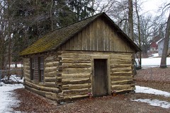 | Urjans Iverson House | building | 1982 | 82003001 |
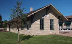 | Little Falls and Dakota Depot | building | 2006 | 06000424 |
 | Minnewaska Hospital | building | 1982 | 82003002 |
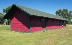 | Northern Pacific Depot | building | 1983 | 83003760 |
 | Daniel Pennie House | building | 1982 | 82003003 |
 | Pope County Courthouse | building | 1982 | 82002997 |
 | Sunset Beach Hotel | building | 1982 | 82002998 |
 | Terrace Historic District | district | 1982 | 82002999 |
 | Terrace Mill Historic District | district | 1979 | 79001252 |
Every wildfire the federal occurrence database records inside this county: 54 of them, burning about 2,992 acres. None started naturally and 12 were recorded as arson. Each settlement page carries the fires within five miles of it.
| Reported cause | Fires |
|---|---|
| Debris and open burning | 22 |
| Arson/incendiarism | 12 |
| Missing data/not specified/undetermined | 9 |
| Recreation and ceremony | 5 |
| Railroad operations and maintenance | 4 |
| Equipment and vehicle use | 2 |
The five largest, by the area the report gives. One of them was set deliberately.
| Date | Cause | Size | Reported by | Name on the report |
|---|---|---|---|---|
| 29 April 1992 | Debris and open burning | 404 acres | Morris National Wildlife Refuge | KOLSTAD LA |
| 23 March 2010 | Debris and open burning | 321 acres | Morris National Wildlife Refuge | GLACIAL LAKE |
| 25 April 2000 | Debris and open burning | 303 acres | Morris National Wildlife Refuge | GLACIAL LK |
| 20 October 2003 | Debris and open burning | 252 acres | Morris National Wildlife Refuge | ROLLING FORKS WPA |
| 10 April 2003 | Debris and open burning | 250 acres | Minnesota Department of Natural Resources | not named |
| 26 April 1993 | Debris and open burning | 235 acres | Minnesota Department of Natural Resources | not named |
| 22 April 2000 | Missing data/not specified/undetermined | 180 acres | Minnesota Department of Natural Resources | not named |
| 15 April 2003 | Arson/incendiarism | 148 acres | Minnesota Department of Natural Resources | not named |
Every settlement page carries the fires within five miles of it - see the settlement index below.
The NOAA Storm Events Database holds 301 reports for this county, causing no deaths, 15 injuries and about $4,673,000 in recorded property damage. Each settlement page carries the reports that name it.
| Kind of event | Reports |
|---|---|
| Hail | 131 |
| Thunderstorm Wind | 109 |
| Tornado | 30 |
| Funnel Cloud | 16 |
| Flash Flood | 11 |
| Flood | 3 |
| Lightning | 1 |
The most serious of them, by death, then injury, then recorded damage. The accounts are quoted exactly as the forecast office filed them.
| When | Event | Place named | Harm | What the report says |
|---|---|---|---|---|
| June 1964 | Tornado (F3) | not stated | 13 hurt, $250,000 | no account filed |
| July 2003 | Thunderstorm Wind | Starbuck | 2 hurt | Gust measured by MNDOT Road Weather System 9 S Starbuck. Hundreds of trees were snapped or downed at Glacial Lakes State Park, which was nearly full of campers for the holiday weekend. Falling trees caused minor injuries to two campers. Nearby, five barns were downed and several empty grain bins were blown over. The RWIS was still measuring a gust of 61 knots at 0013 CST. |
| June 2013 | Thunderstorm Wind | Gilchrist | $1,000,000 | One barn collapsed, many pole sheds, garages, out buildings, and silos were heavily damaged. Damage extended across most of far southern Pope County. |
| August 2011 | Thunderstorm Wind | Farwell | $1,000,000 | Numerous trees and power lines were blown down along a sixteen mile long path of damage with a swath about six to eight miles wide that occurred from Farwell and northern Starbuck, to the southern side of Lake Minnewaska and the southeast side of Glenwood. An electric transmission company had three metal truss towers collapse about 2.5 miles east of Lowry. The towers were 187 feet tall, with 1700 feet of spacing between each tower. Using the enhanced Fujita scale, damage indicator 24 (ETL) applies very well; its lower bound for a degree of damage 6 is 116 mph (101 knots). The towers were rated for 120 mph. Eight miles to the southeast of the towers, on the southern fringe of the swath, an observer with a home weather station two miles south of Glenwood measured 91 mph before the power went out. The anemometer was mounted ten feet above the top of the house, and was above the tree tops. Windows were blown in and shingles ripped off. The roof of an adjacent house was blown away, and numerous trees were toppled or broken. |
| September 2017 | Tornado (EF1) | Gilchrist | $500,000 | A tornado touched down near Camp Lake in Swift County and then moved into Pope County, where it destroyed two machine sheds and several other outbuildings. The tornado tore through many fields, damaging or destroying much corn. It finally dissipated just after crossing State Highway 104, just before reaching Johanna Lake. |
| May 2022 | Thunderstorm Wind | Gilchrist | $250,000 | A silo and barn were destroyed west-northwest of Swift Falls. |
| July 2009 | Tornado (EF2) | Gilchrist | $250,000 | A National Weather Service storm survey and visual reports confirmed that a tornado moved through portions of Swift and Pope Counties in west central Minnesota where two turkey barns and several outbuildings were destroyed, with extensive tree damage throughout the entire path. Maximum damage was EF-2 with estimated winds of 111-119 mph. In the town of Swift Falls, two residences were damaged along with two garages that were destroyed. The tornado was produced minor crop damage northeast of Swift Falls. |
| July 1966 | Tornado (F1) | not stated | $250,000 | no account filed |
| May 1953 | Tornado (F2) | not stated | $250,000 | no account filed |
| July 2010 | Tornado (EF0) | Gilchrist | $200,000 | Dozens of trees were broken, uprooted or toppled. Many trees fell on lake homes on the north side of Scandinavia Lake. A few sheds were destroyed, the roof of one house was partially removed, two campers were destroyed, and a pontoon was flipped. After the tornado moved away from the lake, a storm chaser filmed it during its rope stage moving across open fields. The chaser commented that the tornado was rain-wrapped, which was consistent with public reports. |
| April 2001 | Flash Flood | Countywide | $200,000 | no account filed |
| June 2012 | Thunderstorm Wind | Terrace | $100,000 | Severe straight-line winds caused a widespread area of damage from north of Terrace, east-northeast through the Sedan area towards Grove Lake. Damages consisted of uprooted trees, structural damage, and damage to grain bins. |
| July 2001 | Thunderstorm Wind | Starbuck | $100,000 | Hundreds of trees down, some on houses, businesses and vehicles. Numerous docks and boats flipped along Lake Minnewaska in Starbuck. |
| July 1997 | Flash Flood | Glenwood | $100,000 | 3 inches of rain in 45 minutes resulted in basement flooding. Damage estimate for entire county. |
| August 1999 | Lightning | Glenwood | $50,000 | Small fire in Church bell tower. |
| August 2021 | Thunderstorm Wind | Glenwood | $25,000 | Several large trees, and powerlines were blown down in Glenwood, some were blocking roads. South of Kensington, several larger tree branches were blown down. Other areas along highway 55 had some tree branches blown down. Trees and powerlines also blown down on the east side of Grove Lake, with two reported pontoons flipped over on Lake Minnewaska. |
| July 2002 | Flash Flood | Countywide | $25,000 | Street flooding was widespread in Glenwood, due to four to six quick inches of rain. The most significant flooding occurred in the northeast portion of Glenwood, washing out some alleys and ripping the blacktop off some city streets. The Glenwood Public Works Director measured five inches of rain in one half hour, beginning around 5 am LST. |
| June 1973 | Tornado (F0) | not stated | $25,000 | no account filed |
| July 1966 | Tornado (F0) | not stated | $25,000 | no account filed |
| July 1959 | Tornado (F2) | not stated | $25,000 | no account filed |
| July 2023 | Thunderstorm Wind | Cyrus | $10,000 | Reports of trees and powerlines down east of Hancock along county road 2. One report of a tree over a home. |
| August 2021 | Thunderstorm Wind | Long Beach | $10,000 | There were numerous reports of large tree branches blown down. There was also damage to MNDOT road signs and damage to cornfields. |
| May 2016 | Tornado (EF0) | Villard | $10,000 | A few boats were flipped, a shed was damaged and shingles were blown off a roof near Amelia Lake. |
| June 2003 | Tornado (F1) | Glenwood | $10,000 | Brief touchdown on the southeast shore of Lake Minnewaska. Tornado flipped over a camper and knocked down trees, some of which fell on the roof of a cabin. |
| May 2018 | Thunderstorm Wind | Cyrus | $5,000 | A large pole shed was damaged near Lake Emily, east of Hancock. |
| August 2020 | Tornado (EF0) | Farwell | $2,000 | A storm chaser filmed a tornado and the local sheriff provided information about the storm damage in Pope County. The tornado tracked northeast for 1.2 miles, clipping the town of Farwell. Several trees were downed, large tree branches were broken and several power poles were blown down. |
| June 2005 | Flash Flood | Glenwood | $1,000 | A dirt berm had to be constructed on Highway 28-29 to stop flood waters from flowing across the highway near the fairgrounds on the northwest side of town. Low lying property and a few roads nearby were flooded. An estimated 2.5 inches of rain fell in 30 minutes in Glenwood. |
| June 2025 | Thunderstorm Wind | Villard | - | Boat lifts and canopies overturned on Lake Reno. |
| June 2025 | Thunderstorm Wind | Glenwood | - | Trees and power lines reported down in Glenwood. |
| June 2025 | Thunderstorm Wind | Villard | - | Thunderstorm winds estimated at 60 mph downed several trees, including one on a trailer near the town of Villard. |
| June 2025 | Thunderstorm Wind | Starbuck | - | Trees and power lines reported down in Starbuck. |
| July 2025 | Thunderstorm Wind | Starbuck | - | Multiple large branches were brought down by thunderstorm wind gusts. |
| July 2025 | Thunderstorm Wind | Starbuck | - | Measured by a MNDOT road weather station. |
| April 2023 | Flood | Farwell | - | A combination of record setting seasonal snowfall, high snow water equivalent values, and rapid snow melt led to low lying areas, ditches, and ravines across the county to flood for a prolonged period of time. Road infrastructure such as bridges, gravel roads, and culverts experience varied degrees of damage caused by rapid runoff. Pope County Emergency Management reported $94,000 in damages to roads and bridges. |
| May 2023 | Hail | Cyrus | - | Law enforcement dispatch reported hail measuring 1.25 inches 6 miles NNE of Clontarf, MN or 12 miles SW of Starbuck, MN. |
| July 2023 | Hail | Glenwood | - | A report of 1 inch hail was received via MPing. |
| July 2023 | Thunderstorm Wind | Starbuck | - | A tree fell on a powerline. |
| July 2023 | Thunderstorm Wind | Gilchrist | - | A tree was down on the road. |
| May 2022 | Tornado (EF0) | Lowry | - | A damage survey revealed about two dozen trees were uprooted or broken. It also destroyed a metal shed. The tornado was filmed on video and posted to social media. |
| May 2022 | Thunderstorm Wind | Lowry | - | Isolated tree damage around Lowry. |
| May 2022 | Thunderstorm Wind | Cyrus | - | Two damage surveys were conducted and the cause of damage appeared to be from a downburst. One mile south of Cyrus, a large machine shed was destroyed when wind blew in the door and lifted off the roof. A portion of a roof was removed from a house, and several dozen trees were blown over. Farther south, two sheds were blown over and trees were damaged. In Cyrus, several dozen trees were uprooted, part of a roof was blown off a metal storage building, part of the roof came off a church, and part of the roof was lifted off a manufactured home. |
| May 2022 | Thunderstorm Wind | Starbuck | - | Isolated tree damage around Starbuck. |
| May 2022 | Thunderstorm Wind | Farwell | - | The roof was lifted off a machine shed. |
| May 2022 | Thunderstorm Wind | Lowry | - | A machine shed was blown apart, other outbuildings were damaged, some siding was peeled away from a house, and two grain bins were damaged. |
| May 2022 | Tornado (EF1) | Cyrus | - | This tornado developed in Swift County, about 5 miles southwest of Danvers, and tracked north until an outflow boundary caught up with it, then the tornado tracked northeast to 7 miles northwest of Clontarf. It then moved through the southeast corner of Stevens County and into Pope County, where it dissipated. Several wooden poles with electrical transmission lines were snapped. Irrigation systems were overturned, trees were damaged, and some structural damage to homes and farm outbuildings also resulted. Maximum winds were estimated at 100 mph. |
| May 2022 | Tornado (EF1) | Starbuck | - | A tornado developed about 4 miles west of Starbuck and tracked northeast. A small outbuilding was completely destroyed and debris was spread north northwest. A truck and trailer were overturned on Highway 28. Maximum winds were estimated at 90 mph. |
| May 2022 | Tornado (EF1) | Cyrus | - | Tornado spun up just west of Lake Emily and tracked northeast. Some trees were snapped and farm outbuildings were damaged. Maximum winds were estimated at 95 mph. This tornado was filmed on video. |
| May 2022 | Tornado (EF1) | Glenwood | - | A tornado originated on the east side of Lake Reno in Pope County. At first, it damaged about a dozen trees, but quickly became more intense and broke or uprooted several hundred trees before entering Douglas County. Maximum winds for the Pope County portion were estimated at 105 mph. |
| August 2021 | Thunderstorm Wind | Glenwood | - | A trained spotter had a hand held wind sensor that measured the wind gust. |
| August 2021 | Thunderstorm Wind | Villard | - | There were numerous large trees blown down along Highway 29, and along Lake Reno. |
| June 2020 | Hail | Glenwood | - | A social media picture of quarter size hail was noted. |
| July 2020 | Thunderstorm Wind | Starbuck | - | There were numerous large tree branches that blew down around Starbuck. |
| July 2019 | Hail | Farwell | - | A swath of large hail, with a measured report of quarter size near Farwell, occurred across northwest Pope County. |
| September 2017 | Thunderstorm Wind | Gilchrist | - | About two hundred trees were broken or uprooted due to the rear flank downdraft that accompanied the Camp Lake tornado. This damage was one to two miles southeast of the dissipation point of the tornado. |
| September 2017 | Thunderstorm Wind | Terrace | - | A couple dozen trees were blown down or broken. Damage was scant, and therefore the storm survey was unable to determine if this was downburst or the continuation of the Camp Lake tornado. Radar data suggest it was probably downburst winds in the wake of the tornado. |
| June 2016 | Funnel Cloud | Cyrus | - | A funnel cloud was noted for a few minutes east of Cyrus. |
| May 2015 | Funnel Cloud | Sedan | - | Video from a storm chaser showed a funnel that was completely separate from the circulation that produced the Sedan tornado and the tornado 2 to 4 miles north of Sedan from 1841 to 1847. It is possible this touched down, but there is not enough evidence to be certain. |
| May 2015 | Tornado (EF0) | Gilchrist | - | This tornado was recorded on video by multiple storm chasers. It briefly touched down in an open field. |
| May 2015 | Tornado (EF0) | Terrace | - | This tornado mostly moved across open fields, and was recorded on video by numerous storm chasers and spotters. After it touched down in an open field east of Terrace, it lifted off briefly and came back down a couple of times before moving through the western edge of Sedan. The tornado caused about a dozen trees to be uprooted at a cemetery on the northwest edge of Sedan. This was a multiple vortex tornado. It also appears there may have been a satellite tornado that touched down in the back yard of a house on County Road 29, 1/2 mile south of Sedan, but the video is inconclusive as to whether it was a satellite tornado or part of the main tornadic circulation. |
| May 2015 | Tornado (EF0) | Sedan | - | A tornado touched down in an open field. It was recorded on video by numerous storm chasers. |
The Survey's mineral resources record lists 3 workings inside this county. All of them still produce. Each settlement page carries the workings within five miles of it.
| Commodity | Workings |
|---|---|
| Sand and Gravel, Construction | 3 |
The least common of them first, because a county's hundredth gravel pit says nothing its first ten did not.
| Where | Site | Commodity | Status | Recorded |
|---|---|---|---|---|
| North Pit | Sand and Gravel, Construction | Producer | ||
| Schmidgall Starbuck Pit | Sand and Gravel, Construction | Producer | ||
| Starbuck Sand and Gravel Pit | Sand and Gravel, Construction | Producer |
Named settlements recorded in the Geographic Names Information System, each with the topographic sheets covering it. Villages, hamlets and abandoned places alike. Each is shown with the nearest named watercourse or landform and the survey quadrangle it falls on.