 Block
From the record
4 National Register listings published here.
Sources: the National Register database, National Park Service
55 topographic sheets cover 26 settlements here, and 4 properties are on the National Register of Historic Places.
4 National Register listings published here.
Sources: the National Register database, National Park Service
Every property in this county listed on the National Register of Historic Places, with the year it was listed and the federal nomination document.
| Photograph | Property | Type | Listed | Reference |
|---|---|---|---|---|
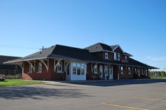 | Canadian National Depot | building | 1982 | 82003034 |
| Lodge Boleslav Jablonsky No. 219 | building | 2002 | 02000936 | |
| Roseau County Courthouse | building | 1985 | 85001763 | |
| Roseau Memorial Arena | building | 2024 | 100011014 |
Every wildfire the federal occurrence database records inside this county: 958 of them, burning about 161,765 acres. 19 started naturally and 310 were recorded as arson. Each settlement page carries the fires within five miles of it.
| Reported cause | Fires |
|---|---|
| Debris and open burning | 465 |
| Arson/incendiarism | 310 |
| Missing data/not specified/undetermined | 64 |
| Equipment and vehicle use | 45 |
| Natural | 19 |
| Smoking | 18 |
| Recreation and ceremony | 16 |
| Power generation/transmission/distribution | 8 |
| Railroad operations and maintenance | 8 |
| Misuse of fire by a minor | 2 |
| Other causes | 2 |
| Fireworks | 1 |
The five largest, by the area the report gives. Three of them were set deliberately.
| Date | Cause | Size | Reported by | Name on the report |
|---|---|---|---|---|
| 5 October 2011 | Debris and open burning | 28,810 acres | Minnesota Department of Natural Resources | JUNEBERRY 3 |
| 26 April 2007 | Arson/incendiarism | 24,945 acres | Minnesota Department of Natural Resources | JUNEBERRY |
| 29 March 2003 | Debris and open burning | 15,000 acres | Minnesota Department of Natural Resources | CANADA FIRE |
| 17 October 1995 | Missing data/not specified/undetermined | 6,000 acres | Minnesota Department of Natural Resources | not named |
| 6 October 2006 | Missing data/not specified/undetermined | 5,700 acres | Minnesota Department of Natural Resources | PEATLAND FIRE |
| 25 April 1998 | Arson/incendiarism | 5,140 acres | Minnesota Department of Natural Resources | not named |
| 15 April 2015 | Debris and open burning | 4,550 acres | Agassiz National Wildlife Refuge | PALSBURG |
| 22 April 1994 | Arson/incendiarism | 3,800 acres | Minnesota Department of Natural Resources | not named |
Every settlement page carries the fires within five miles of it - see the settlement index below.
The NOAA Storm Events Database holds 452 reports for this county, causing no deaths, 2 injuries and about $24,931,950 in recorded property damage. Each settlement page carries the reports that name it.
| Kind of event | Reports |
|---|---|
| Hail | 251 |
| Thunderstorm Wind | 133 |
| Tornado | 38 |
| Flash Flood | 12 |
| Funnel Cloud | 9 |
| Flood | 6 |
| Heavy Rain | 2 |
| Lightning | 1 |
The most serious of them, by death, then injury, then recorded damage. The accounts are quoted exactly as the forecast office filed them.
| When | Event | Place named | Harm | What the report says |
|---|---|---|---|---|
| June 1997 | Tornado (F2) | Greenbush | 1 hurt, $250,000 | no account filed |
| July 1982 | Tornado (F1) | not stated | 1 hurt, $25,000 | no account filed |
| August 2006 | Tornado (F3) | Warroad | $20,000,000 | Tornado number two of a series tracked east-southeast for about 4 miles across the northern part of Warroad. The main tornado appeared to have touched down about a mile west of the Marvin Windows plant complex at the northwest corner of Warroad. The tornado grew to around 500 yards wide as it moved across the Lakeview Park and campground area. The tornado apparently lifted as it passed into Muskeg Bay of the Lake of the Woods. Peak wind speeds were estimated from 160 to 180 mph.Damage was extensive along the tornado path in Warroad. At the Marvin Windows plant, the roof was damaged and 16 semi trailers were overturned. Several of the trailers were full with new windows, which were a complete loss. The nearby Pepsi plant had its sign blown down. At the Warroad City Park and Campground, 30 to 40 campers were destroyed and roughly 10 boats were damaged or sunk. The city pool, which had been recently renovated, was also damaged. The Trading Post Gift Shop was completely destroyed. Many large trees were also snapped off or broken into pieces. Eight to 10 homes also sustained damage. |
| April 2006 | Flood | Countywide | $1,320,000 | Due to the quick snowmelt, water quickly drained into low areas, damaging around 46 different road and bridge sites around the county. The fifth highest modern-day river stage of 19.71 feet (unofficial) was recorded on the Roseau River in Roseau on April 2nd. In the city of Roseau, the U.S. Army Corps of Engineers put fill in 3 different low areas. State Highway 310 at the Canadian border was closed due to flooding. Roseau County received a Presidential Disaster Declaration for damages caused by spring flooding. |
| July 2011 | Thunderstorm Wind | Greenbush | $700,000 | Numerous large tree limbs were broken down around Greenbush. Trees were blown down on cars and roofs of homes. Power lines were also downed. Large commercial scale steel grain bins were dented or collapsed inward at the elevator complex. Smaller farm scale steel bins nearby were torn from their foundations and rolled. |
| August 1993 | Tornado (F0) | Roseau | $500,000 | A tornado briefly touched down near Roseau damaging a warehouse. Damage was estimated at $80,000. |
| September 2014 | Tornado (EF1) | Pelan | $300,000 | The tornado snapped or uprooted numerous trees along its path, destroyed two steel grain bins at one farmstead, and severely damaged three more at subsequent farmsteads. Steel roofing panels and doors were town off of pole sheds and flung dozens of yards. Peak winds were estimated at 100 mph. |
| September 2019 | Flash Flood | Badger | $250,000 | Streets, low spots, rivers, and basements were flooded by 4 to 9 inches of rain over a short duration of time. Cars that got stuck in the flood waters were abandoned where they stalled. Farm fields and access roads were also flooded. |
| August 1966 | Tornado (F1) | not stated | $250,000 | no account filed |
| July 2010 | Thunderstorm Wind | Pelan | $200,000 | Downburst winds raked across portions of western Roseau County. Numerous trees were knocked down across portions of Polonia and Barto Townships. Several farmsteads had tree and roofing damage. Some forested areas saw 1 of every 4 trees knocked down. |
| July 2001 | Flash Flood | Greenbush | $200,000 | Water washed out county road 7. |
| July 2001 | Flash Flood | Roseau | $200,000 | Street flooding was reported in Roseau. |
| June 2020 | Tornado (EF1) | Pinecreek Arpt | $150,000 | A tornado was observed as it developed off the north end of a downburst corridor moving across Dieter and Ross townships. The tornado tracked through a farmstead, where it demolished a pole shed and spread debris for nearly a mile to the north. Numerous trees were also snapped. Peak winds were estimated at 105 mph. |
| June 2020 | Thunderstorm Wind | Badger | $100,000 | Downburst winds blew across northern Barto, Eastern Soleer, and Mosse townships, snapping numerous trees in shelterbelts and farmsteads throughout the area. A steel clad pole shed was torn open and spread along a half mile path to the east, where a two stall shop was torn open. |
| June 1997 | Hail | Badger | $100,000 | no account filed |
| July 2011 | Thunderstorm Wind | Badger | $50,000 | Several large three foot diameter trees were broken down in Badger. A wooden storage shed at the cemetery was torn off its foundation and flipped over. |
| August 2002 | Thunderstorm Wind | Roseau | $50,000 | Two FEMA trailers and one semi truck were blown over. 1000 feet of electrical wiring needed replacement in the downtown area. |
| June 1976 | Tornado (F1) | not stated | $25,000 | no account filed |
| July 1967 | Tornado (F1) | not stated | $25,000 | no account filed |
| July 2004 | Thunderstorm Wind | Fox | $20,000 | A 30x60 foot storage shed was blown off its foundation and destroyed. Several trees, greater than 6 inches in diameter, were uprooted. |
| August 2003 | Tornado (F1) | Wannaska | $20,000 | A 40x72 foot storage barn was completely demolished, with debris spread downwind several hundred feet. |
| September 2002 | Thunderstorm Wind | Roseau | $15,000 | Trees and powerlines were blown down, boats and trailers were flipped over, and fences were pushed over by the strong wind. |
| August 2002 | Thunderstorm Wind | Roseau | $15,000 | Strong winds produced the most damage at the KRWB radio station in Roseau. The wind blew over 2 large trees, shattered the base of a satellite dish, moved a shed 100 feet, and knocked down signs and antennas. |
| July 1999 | Thunderstorm Wind | Roosevelt | $15,000 | Trees were blown down across roads and a tower was blown over. |
| August 2006 | Tornado (F0) | Ross | $10,000 | A storm survey confirmed an intermittent 3 mile damage track. A small vehicle shelter and yard furnishings at two farmsteads was damaged and several trees were snapped off. |
| July 2001 | Thunderstorm Wind | Skime | $10,000 | Powerlines were blown down. |
| July 1999 | Thunderstorm Wind | Roosevelt | $10,000 | A building collapsed in the high wind. |
| June 1999 | Flash Flood | Roseau | $10,000 | The Polaris snowmobile factory in Roseau was flooded by the heavy rain. |
| June 1998 | Thunderstorm Wind | Roseau | $10,000 | Power lines were blown down in the strong wind. |
| July 1997 | Thunderstorm Wind | Roseau | $10,000 | Power lines were blown down east of Roseau. |
| July 1997 | Thunderstorm Wind | Roseau | $10,000 | Power lines were knocked down around the Roseau area due to the high wind. |
| May 2009 | Flood | Duxby | $10,000 | no account filed |
| May 1996 | Flash Flood | Roseau | $10,000 | no account filed |
| July 1996 | Flash Flood | Roseau | $10,000 | no account filed |
| June 2020 | Tornado (EF1) | Greenbush Arpt | $5,000 | A tornado tracked intermittently for about 2 miles. Several trees were snapped and numerous branches were broken down in shelterbelts and groves. Video and eyewitness reports described the tornado as being cut off by rear flank winds and rain as it tracked toward Greenbush. Peak winds were estimated at 95 mph. |
| July 2011 | Lightning | Malung | $5,000 | A fire was started by a lightning strike. |
| July 2011 | Thunderstorm Wind | Homolka | $5,000 | The roof was ripped off of a 180 foot long hay shed. Numerous tree limbs were broken down in farmsteads across Nereson Township. |
| July 2008 | Hail | Wannaska | $5,000 | Hailed for about 15 minutes, or from about 615 pm to 630 pm. Hail size ranged from pea to nickle size. |
| July 2008 | Hail | Swift | $5,000 | Several large tree branches were also blown down. |
| July 1999 | Thunderstorm Wind | Roseau | $5,000 | Metal siding was blown off an apartment building. |
| March 2009 | Flood | Duxby | $5,000 | no account filed |
| April 2009 | Flood | Duxby | $5,000 | no account filed |
| July 2011 | Flash Flood | Strathcona | $2,000 | Street flooding was reported in Strathcona. Several farm access roads were also flooded near town. |
| May 2010 | Flash Flood | Wannaska | $2,000 | Four inches of rain fell in three hours. |
| May 2002 | Thunderstorm Wind | Warroad | $2,000 | A tree was blown down onto a shed. |
| June 2023 | Thunderstorm Wind | Roseau | $1,500 | Public reports a bent foul pole and fencing being pushed down at the Roseau Gilbertson baseball field. Additionally, a foot in diameter tree snapped in town and pulled a power line down. |
| August 2000 | Thunderstorm Wind | Greenbush | $1,000 | Large branches were blown down. |
| July 1997 | Thunderstorm Wind | Roseau | $1,000 | Wind blew down trees north of Roseau. |
| July 2001 | Thunderstorm Wind | Skime | $500 | Large trees were blown down. |
| June 1999 | Thunderstorm Wind | Roseau | $500 | Large trees were blown down. |
| June 1999 | Thunderstorm Wind | Roseau | $500 | Trees were downed by the wind. |
| June 1999 | Thunderstorm Wind | Greenbush | $500 | no account filed |
| July 1983 | Tornado (F2) | not stated | $250 | no account filed |
| June 1998 | Thunderstorm Wind | Badger | $200 | no account filed |
| August 2025 | Thunderstorm Wind | Roseau | - | Report of tree damage at the Roseau Oakcrest Golf Course. Time estimated from radar. |
| June 2024 | Thunderstorm Wind | Wannaska | - | Public reports a few small tree branches down, in addition to downed power lines and dime sized hail. |
| June 2024 | Hail | Roseau Arpt | - | Broadcast Media reports quarter sized hail south of the Roseau airport. |
| June 2024 | Hail | Warroad | - | Public reports half-dollar sized hail in Warroad. |
| June 2024 | Hail | Warroad | - | Trained spotter reports golf ball sized hail southwest of Warroad. |
| June 2024 | Tornado (EF0) | Winner | - | Received a photo of a brief tornado. EM of Roseau county reported no damage. |
The Survey's mineral resources record lists 14 workings inside this county. 12 still produce and 2 are closed or unrecorded. Each settlement page carries the workings within five miles of it.
| Commodity | Workings |
|---|---|
| Sand and Gravel, Construction | 12 |
| Peat | 1 |
| Iron | 1 |
| Manganese | 1 |
The least common of them first, because a county's hundredth gravel pit says nothing its first ten did not.
| Where | Site | Commodity | Status | Recorded |
|---|---|---|---|---|
| Roseau County Peat Deposits | Peat | Occurrence | ||
| Snyder Mine | Iron, Manganese | Past Producer | ||
| Brandvolt Pit and Mill | Sand and Gravel, Construction | Producer | ||
| City Pit | Sand and Gravel, Construction | Producer | ||
| Erickson Pit | Sand and Gravel, Construction | Producer | ||
| Holland Pit & Mill No. 1 | Sand and Gravel, Construction | Producer | ||
| Holland Pit and Mill No. 2 | Sand and Gravel, Construction | Producer | ||
| Roseau Pit | Sand and Gravel, Construction | Producer | ||
| Springsteel Pit and Mill | Sand and Gravel, Construction | Producer | ||
| Walrath Pit and Mill | Sand and Gravel, Construction | Producer | ||
| Warroad Mill | Sand and Gravel, Construction | Producer | ||
| Warroad Pit No. 1 | Sand and Gravel, Construction | Producer | ||
| Warroad Pit No. 2 | Sand and Gravel, Construction | Producer | ||
| West Greenbush Pit and Mill | Sand and Gravel, Construction | Producer |
Named settlements recorded in the Geographic Names Information System, each with the topographic sheets covering it. Villages, hamlets and abandoned places alike. Each is shown with the nearest named watercourse or landform and the survey quadrangle it falls on.
Northwest Roseau unorganized territory · 56751 · Caribou NE quadrangle
12 sheets, 1930 to 1985
No longer a settlement
Warroad city · 56763 · On Warroad River · Warroad quadrangle
10 sheets, 1918 to 1976
Northwest Roseau unorganized territory · 56735 · Caribou quadrangle
11 sheets, 1930 to 1985
No longer a settlement
Southeast Roseau unorganized territory · 56751 · Mulligan Lake SW quadrangle
6 sheets, 1954 to 1976
The vanished settlements of Roseau County: the places named above that are no longer on the map.