 Block
From the record
4 National Register listings published here.
Sources: the National Register database, National Park Service
24 topographic sheets cover 10 settlements here, and 4 properties are on the National Register of Historic Places.
4 National Register listings published here.
Sources: the National Register database, National Park Service
Every property in this county listed on the National Register of Historic Places, with the year it was listed and the federal nomination document.
| Photograph | Property | Type | Listed | Reference |
|---|---|---|---|---|
 | Commercial Hotel | building | 1988 | 88003010 |
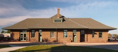 | Northern Pacific Passenger Depot | building | 1989 | 88003012 |
| Peterson-Biddick Seed and Feed Company | building | 1989 | 88003227 | |
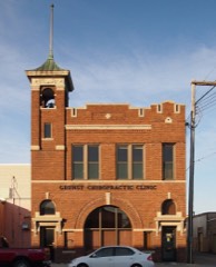 | Wadena Fire and City Hall | building | 1989 | 88003228 |
Every wildfire the federal occurrence database records inside this county: 683 of them, burning about 6,636 acres. 12 started naturally and 116 were recorded as arson. Each settlement page carries the fires within five miles of it.
| Reported cause | Fires |
|---|---|
| Debris and open burning | 346 |
| Arson/incendiarism | 116 |
| Equipment and vehicle use | 73 |
| Missing data/not specified/undetermined | 73 |
| Recreation and ceremony | 26 |
| Smoking | 15 |
| Natural | 12 |
| Railroad operations and maintenance | 9 |
| Power generation/transmission/distribution | 7 |
| Misuse of fire by a minor | 4 |
| Fireworks | 1 |
| Other causes | 1 |
The five largest, by the area the report gives. Three of them were set deliberately.
| Date | Cause | Size | Reported by | Name on the report |
|---|---|---|---|---|
| 8 April 2012 | Equipment and vehicle use | 1,520 acres | Minnesota Department of Natural Resources | JEEP FIRE |
| 4 May 1992 | Debris and open burning | 357 acres | Minnesota Department of Natural Resources | not named |
| 28 March 1998 | Arson/incendiarism | 224 acres | Minnesota Department of Natural Resources | not named |
| 7 May 2000 | Arson/incendiarism | 198 acres | Minnesota Department of Natural Resources | not named |
| 7 May 2000 | Arson/incendiarism | 197 acres | Minnesota Department of Natural Resources | not named |
| 17 May 2008 | Debris and open burning | 182 acres | Minnesota Department of Natural Resources | not named |
| 29 October 2008 | Missing data/not specified/undetermined | 142 acres | Minnesota Department of Natural Resources | not named |
| 31 March 2003 | Debris and open burning | 126 acres | Minnesota Department of Natural Resources | not named |
Every settlement page carries the fires within five miles of it - see the settlement index below.
The NOAA Storm Events Database holds 322 reports for this county, causing no deaths, 30 injuries and about $9,672,850 in recorded property damage. Each settlement page carries the reports that name it.
| Kind of event | Reports |
|---|---|
| Hail | 162 |
| Thunderstorm Wind | 111 |
| Tornado | 22 |
| Flash Flood | 10 |
| Funnel Cloud | 10 |
| Flood | 4 |
| Heavy Rain | 2 |
| Lightning | 1 |
The most serious of them, by death, then injury, then recorded damage. The accounts are quoted exactly as the forecast office filed them.
| When | Event | Place named | Harm | What the report says |
|---|---|---|---|---|
| June 2010 | Tornado (EF4) | Wadena | 20 hurt | This multi-vortex wedge tornado began in Otter Tail County about 3 miles southwest of the city of Wadena at 459 PM CDT. It tracked for about 2 miles in Otter Tail County, then it continued for another 8 miles in Wadena County. The tornado ravaged the western half of the community of Wadena. Numerous homes were flattened to the ground and at least one was completely swept from its foundation and destroyed. Public and industrial buildings were wrecked, the fairgrounds were damaged, and headstones in the cemetery were overturned. School buses and vehicles were propelled through the air for hundreds of yards. The tornado hit on the day of the Wadena all-school reunion, so many additional people were in the area. Roughly 100 people were displaced from their homes. Peak winds were estimated at 170 mph. |
| July 2000 | Tornado (F2) | Verndale | 3 hurt, $500,000 | A tornado that formed near Verndale intensified as it reached the Aldrich area. A mobile home, garage, barn, and 3 vehicles were destroyed 3 miles east of Aldrich. Two people, inside the mobile home when the tornado hit, suffered cuts, bruises, and a sprained ankle. The couples' son, sitting inside a car parked outside the mobile home, also sustained cuts and bruises. A horse trailer was pushed into his car and then into some nearby trees. Quite a bit of tree damage occurred along the damage path. The tornado then passed out of Wadena county and into Todd county. |
| September 1998 | Thunderstorm Wind | Verndale | 3 hurt, $500,000 | A trailer home rolled over in the wind, injuring two of the three occupants inside. Nearby, a man was injured when a 2x4 was blown through his kitchen window, hitting him in the side. Over 10 barns in the area were severely damaged. |
| August 1977 | Tornado (F2) | not stated | 2 hurt, $250,000 | no account filed |
| June 2008 | Tornado (EF2) | Menahga | 1 hurt, $5,000,000 | The tornado touched down near the south end of Stocking Lake and tracked north-northeast for nearly 14 miles. It crossed into Hubbard County about 4 miles north-northeast of Menagha by 920 am CDT. It then tracked an additional 9 miles and lifted about 3 miles northeast of Park Rapids by 934 am CDT. The maximum tornado width was about 450 yards with peak winds of 130 mph. Eight large turkey barns were destroyed and several homes damaged along with hundreds of acres of forest. One man working near a turkey barn was injured. |
| June 2005 | Thunderstorm Wind | Wadena | 1 hurt | Trees were blown down all around Wadena. Trees fell on buildings, cars, and power lines. A church under construction lost its roof and a wall collapsed. The strong winds slammed a man into a wall. The man went to the emergency room, but suffered no major injuries. |
| May 2022 | Tornado (EF2) | Aldrich | $1,000,000 | This tornado was wrapped in damaging downburst winds and rain as it rapidly tracked to the north northeast from the Todd County line, across far southeast Wadena County for about 9.5 miles, to the Cass County line. It snapped numerous single pole and double X-braced power poles. it tumbled at least three center pivot irrigation systems. Numerous oak, ash, and pine trees were snapped. The Old Wadena and Bullard Campgrounds had swaths of pine trees laid down. One cabin had the roof and sidewalls torn out. Peak winds to 130 mph. Time estimated based on radar. |
| October 1996 | Tornado (F2) | Sebeka | $750,000 | This tornado followed a path along Highway 71 and passed through the west side of Sebeka. One car dealership reported approximately 40 vehicles damaged, at a loss of $250,000. Numerous farm buildings and businesses were also damaged. |
| September 1998 | Thunderstorm Wind | Wadena | $250,000 | A roof from an adjacent building blew into the display vehicles at a car dealership and twisted around them. A church also lost its bell tower. |
| October 1996 | Thunderstorm Wind | Nimrod | $250,000 | no account filed |
| July 1966 | Tornado (F1) | not stated | $250,000 | no account filed |
| July 1966 | Tornado (F2) | not stated | $250,000 | no account filed |
| July 2011 | Thunderstorm Wind | Wadena | $100,000 | A building under construction at the fairgrounds was blown down. |
| July 2010 | Hail | Sebeka | $100,000 | Hail ranging from 2 to 4 inch diameter fell in an area between Sebeka and Blue Grass. Hail punched large holes through a steel shop roof and broke out several windows. |
| May 2022 | Tornado (EF1) | Staples | $50,000 | This tornado was wrapped in damaging downburst winds and rain as it rapidly tracked to the northeast from about 2 NW of the Staples Airport to about 2 NNE of the Staples Airport. It appears to have developed roughly half a mile east of an earlier tornado, based on divergent tree damage paths and supported by radar depictions. It snapped several poplar, ash, and spruce trees along its path. Peak winds to 90 mph. Time estimated based on radar. |
| June 2014 | Hail | Blue Grass | $50,000 | There was some localized flooding from the heavy rain and a report of basement flooding. |
| July 2014 | Flood | Wadena | $50,000 | Heavy rain led to street, basement, and trailer park flooding near Wadena. A total of eight inches of rain was measured in Wadena. |
| June 2008 | Thunderstorm Wind | Wadena | $50,000 | The wind knocked down a large tree. |
| June 2008 | Thunderstorm Wind | Wadena | $50,000 | Several large 3 to 5 inch tree branches were blown down around town, which resulted in scattered power outages. |
| September 1998 | Thunderstorm Wind | Verndale | $50,000 | A woman and her three children escaped without injury when their house was hit with the strong winds. Several windows shattered and part of the roof blew off. A barn, silo, machine shed, and several trees were also destroyed. |
| September 1964 | Tornado (F1) | not stated | $25,000 | no account filed |
| August 2000 | Lightning | Menahga | $20,000 | Lightning struck a garage, which ignited a fire that burned the entire structure down. |
| July 1999 | Thunderstorm Wind | Verndale | $20,000 | A 110 foot storage shed was blown down. |
| June 2001 | Thunderstorm Wind | Menahga | $15,000 | Numerous trees were blown down in Menahga, with one tree falling on a house. |
| June 2018 | Flash Flood | Nimrod | $10,000 | Up to 7 inches of rain fell, making the low spots in fields look like lakes. Water also covered several roads. |
| July 2010 | Flash Flood | Blue Grass | $10,000 | Four to five inches of rain fell, flooding a yard. |
| September 1998 | Thunderstorm Wind | Verndale | $10,000 | An office building and a storage shed sustained roof damage. |
| June 1996 | Hail | Menahga | $10,000 | no account filed |
| June 2018 | Flash Flood | Wadena | $5,000 | About 5.25 inches of rain fell, causing a few washouts of gravel roads. Quite a bit of ponding also occurred in area fields and low lying areas. |
| July 2002 | Thunderstorm Wind | Menahga | $5,000 | Strong winds blew down numerous trees around Spirit Lake. One property owner reported that his dock, boat lift, and pontoon were flipped completely over. |
| July 2002 | Thunderstorm Wind | Wadena | $5,000 | Power lines were blown down. |
| May 2012 | Flood | Sebeka | $5,000 | no account filed |
| March 2009 | Flood | Menahga | $5,000 | no account filed |
| July 1996 | Hail | Oylen | $5,000 | no account filed |
| July 1996 | Hail | Oylen | $5,000 | no account filed |
| July 2011 | Flash Flood | Sebeka | $3,000 | Heavy rainfall of two to five inches on top of previously saturated soils produced excessive runoff into the Redeye River drainage. Localized flooding occurred near the river through portions of Redeye and Rockwood townships. |
| July 1968 | Tornado (F0) | not stated | $2,500 | no account filed |
| June 1964 | Tornado (F1) | not stated | $2,500 | no account filed |
| July 2016 | Flash Flood | Sebeka | $2,000 | Fields and access roads were flooded in Red Eye and northern Rockwood townships. Cat and Kitten creeks and the Red Eye River were full and still rising. |
| July 2009 | Flash Flood | Staples | $2,000 | Flooding occurred to several fields, yards, and access roads across fields in extreme southeastern Thomastown township, north of the community of Staples. |
| July 2001 | Thunderstorm Wind | Sebeka | $2,000 | Trees were blown down in Sebeka. |
| July 2002 | Thunderstorm Wind | Verndale | $1,000 | Large tree branches were blown down in the wind. |
| June 2001 | Thunderstorm Wind | Verndale | $1,000 | Several trees were uprooted. |
| July 2001 | Thunderstorm Wind | Nimrod | $1,000 | Several trees were blown down. |
| June 1998 | Thunderstorm Wind | Verndale | $500 | 10 to 15 trees were blown down in the strong wind. |
| July 1978 | Tornado (F0) | not stated | $250 | no account filed |
| July 2002 | Thunderstorm Wind | Aldrich | $100 | Tree branches were blown down. |
| May 2025 | Thunderstorm Wind | Wadena | - | Large trees snapped. |
| May 2025 | Thunderstorm Wind | Wadena | - | Large trees snapped SSW of Wadena. |
| August 2024 | Hail | Central | - | Via Facebook, public reports quarter sized hail. |
| August 2024 | Hail | Staples | - | Law Enforcement reports golf ball sized hail around Staples. Delayed report. |
| August 2024 | Hail | Central | - | Golf ball sized hail ongoing in Staples, MN. |
| August 2024 | Hail | Wadena | - | Trained Spotter reports quarter sized hail north of Wadena, MN. |
| August 2024 | Hail | Wadena | - | Facebook report of mostly baseball sized hail, with a few as large as softballs. No stones smaller than golf balls. |
| August 2024 | Hail | Wadena | - | Trained spotter reports 3 inch hail in Wadena. Largest hailstones only lasted 3 minutes, but hail still ongoing at time of report. |
| August 2024 | Hail | Wadena Arpt | - | Public reports golf ball sized hail near the Wadena airport, with heavy rain. |
| August 2024 | Hail | Verndale | - | Law Enforcement reports quarter sized hail around Verndale MN. |
| August 2024 | Hail | Verndale | - | Public reports golf ball sized hail north of Verndale, MN. |
| August 2024 | Hail | Wadena | - | Public reports 2.5 inch hail around Wadena. |
| August 2024 | Hail | Wadena Arpt | - | Public reports up to 4 inch hail. Mostly ping pong balls but the largest stones were up to softball sized. |
The Survey's mineral resources record lists 3 workings inside this county. All of them still produce. Each settlement page carries the workings within five miles of it.
| Commodity | Workings |
|---|---|
| Sand and Gravel, Construction | 2 |
| Limestone, General | 1 |
The least common of them first, because a county's hundredth gravel pit says nothing its first ten did not.
| Where | Site | Commodity | Status | Recorded |
|---|---|---|---|---|
| Nanik Marl Pit | Limestone, General | Producer | Marl | |
| Menahga Concrete Pit | Sand and Gravel, Construction | Producer | ||
| Schmitz Pit | Sand and Gravel, Construction | Producer |
Named settlements recorded in the Geographic Names Information System, each with the topographic sheets covering it. Villages, hamlets and abandoned places alike. Each is shown with the nearest named watercourse or landform and the survey quadrangle it falls on.