
BlockBefore
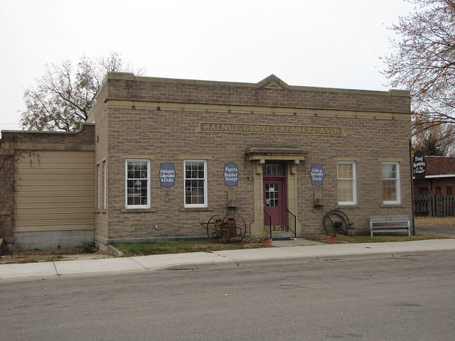
Photograph of Walnut Grove Creamery Association
Photograph by Jatakuck, CC BY-SA 3.0. Via Wikimedia Commons.

Walnut Grove Creamery Association

Listed on the National Register of Historic Places in 2006.

From the record

“Walnut Grove today is an enterprising village with many attractive features. The village is putting in cement curbing on its main street, to be followed with paving.”

The History of Redwood County, Minnesota (1916). Machine-read text.

One of 23 National Register listings published here for Redwood County · listed in 2006 · category: Building.

Sources: the county history on the Internet Archive · the case file at the National Archives · the National Register database, National Park Service
The listing

  • What is counted as historic. The nomination lists 1 building as contributing to the listing.
  • Address. 521 Main St., Walnut Grove, 56180
  • When was it listed? July 2006
  • Category. building
  • City. Walnut Grove city
  • National Register reference number. 06000602 - the number the National Park Service assigned this property when it was listed, and the key its nomination file is catalogued under at the National Archives.

The ground it stands on

3,964 words

The chapter on Walnut Grove City in The History of Redwood County, Minnesota, published 1916 names Walnut Grove. This is what it says, exactly as the scans read.

The vicinity of Walnut Grove has attracted attention since the earliest days by reason of its seventy acres of heavy black walnut. No explanation has ever been made of the presence of these great trees in a region where other trees grew but sparsely, and in a spot far removed from any other groves of the same

Passage source: The History of Redwood County, Minnesota, published 1916.

An early settler in North Hero was Thomas Allen. Allen then a young man of twenty -five years, came to this locality, and after looking about, filed on the southwest quarter of section 20. He then returned to his home and spent the winter. In the spring of 1872 he came back, driving an ox team, and reaching here ahead of the railroad which was put through that year. Mr. Allen still lives in Walnut Grove.

Passage source: The History of Redwood County, Minnesota, published 1916.

Machine-read from a century-old scan, so expect the errors a machine makes: misspelled names, dropped words, stray characters.

Read the whole chapter on Walnut Grove City - 3,964 words on its settlement, mills, schools and churches.

Storms near this property

21 since 1994

Regional context, not property-specific evidence. The National Weather Service names Walnut Grove, the town this property stands in, in 21 storm reports between 1994 and 2025: 11 hail, 8 thunderstorm wind, 1 funnel cloud, 1 flash flood. No death or injury is recorded in these reports. Each account below is quoted exactly as the forecast office filed it, from the NOAA Storm Events Database, and each date opens the federal record of that event.

WhenEvent Place namedHarm What the report says
August 2025Flash FloodWalnut Grove-Law enforcement reported water over portions of US Highway 14 near Walnut Grove, to the point where road/lane markers cannot be seen.
May 2004Thunderstorm WindWalnut Grove-Six inch diameter branches were downed.
June 2003HailWalnut Grove-Minor damage to corn.
July 2002Thunderstorm WindWalnut Grove-Scattered trees down.
July 2001Thunderstorm WindWalnut Grove-Numerous 8 inch branches downed.
August 2000Thunderstorm WindWalnut Grove-Trees and power lines down.
June 1997Thunderstorm WindWalnut Grove-Large trees down. Estimated windspeed.
July 1995HailWalnut Grove-15,000 acres of crops destroyed.
June 1994Thunderstorm WindWalnut Grove-Several trees were blown down from strong thunderstorm winds.
May 2012HailWalnut Grove-no account filed
April 2011HailWalnut Grove-no account filed
August 2010Funnel CloudWalnut Grove-no account filed
August 2009HailWalnut Grove-no account filed
May 2008HailWalnut Grove-no account filed
May 2005HailWalnut Grove-no account filed
June 2004HailWalnut Grove-no account filed
July 2002HailWalnut Grove-no account filed
May 2000HailWalnut Grove-no account filed
July 1999HailWalnut Grove-no account filed
June 1998Thunderstorm WindWalnut Grove-no account filed
July 1998Thunderstorm WindWalnut Grove-no account filed

Every storm recorded in Redwood County

Map coverage status

No historic map-sheet match is published for this property yet. That does not mean no map exists. This record needs a coordinate-quality review before it can be joined to a sheet boundary. Browse the county's mapped places while that work is pending.

Listed places nearby

1 within 8 miles

Other National Register properties close enough to walk or drive between, ordered by distance from this one. Both positions come from the same geocoding pass that matched these properties to their map sheets.

Photograph PropertyDistance Listed
Revere Fire Hall5.1 miles1980

Sources for this property

National Archives recordThe nomination case file for reference 06000602 in Record Group 79.
Redwood CountyAll 23 listed properties in this county.

Provenance

  • Listing record. National Park Service National Register of Historic Places, listed-properties dataset, current to 2026-05-22.
  • Map join. Address geocoded through the United States Census geocoder, then tested against the published boundary of every sheet in the USGS Historical Topographic Map Collection.
  • How this page is made. Listing fields come from federal records; map-sheet coverage is a labelled coordinate-to-boundary calculation, not a source-field claim.
  • Storms. NOAA National Centers for Environmental Information, Storm Events Database https://www.ncei.noaa.gov/stormevents/ A work of the United States government, no copyright under 17 U.S.C. 105. Narratives are quoted verbatim from the National Weather Service report and are not edited or summarised.