 Block
From the record
One of 7 National Register listings published here for McLeod County · listed in 2009 · category: Building.
Sources: the case file at the National Archives · the National Register database, National Park Service

Listed on the National Register of Historic Places in 2009.
One of 7 National Register listings published here for McLeod County · listed in 2009 · category: Building.
Sources: the case file at the National Archives · the National Register database, National Park Service
Regional context, not property-specific evidence. The federal wildfire occurrence database lists 4 fires within 5 miles of Komensky School between 2005 and 2020, burning about 72 acres in total. None started naturally. 1 was recorded as arson. Distance is straight-line from the map coordinates, so a fire counted here may appear on a neighbouring settlement's page as well.
| Reported cause | Fires |
|---|---|
| Debris and open burning | 2 |
| Missing data/not specified/undetermined | 1 |
| Arson/incendiarism | 1 |
The most recent of them, most recent first, with the day each was reported and the service that recorded it.
| Date | Cause | Size | Reported by | Name on the report |
|---|---|---|---|---|
| 9 April 2005 | Arson/incendiarism | 25 acres | Litchfield Wetland Management District | BART |
| 2 December 2011 | Debris and open burning | 2.0 acres | Minnesota Department of Natural Resources | not named |
| 8 November 2020 | Missing data/not specified/undetermined | 45 acres | Litchfield Wetland Management District | MNLFR-FY21-WF-SILVER LAKE WF |
| 29 November 2012 | Debris and open burning | under an acre | Minnesota Department of Natural Resources | not named |
Regional context, not property-specific evidence. The National Weather Service names Hutchinson, the town this property stands in, in 133 storm reports between 1996 and 2025: 64 hail, 55 thunderstorm wind, 9 heavy rain, 2 funnel cloud. The reports record 3 injuries. Each account below is quoted exactly as the forecast office filed it, from the NOAA Storm Events Database, and each date opens the federal record of that event.
| When | Event | Place named | Harm | What the report says |
|---|---|---|---|---|
| June 2004 | Thunderstorm Wind | Hutchinson | 2 hurt | A construction trailer was flipped on the southwest side of town. Two people inside the trailer were injured. Trees were downed in the vicinity. |
| September 2013 | Thunderstorm Wind | Hutchinson | 1 hurt | A large tree fell on a vehicle on Jefferson Street, in Hutchinson, Minnesota. The person in the car was injured. There was a measured wind gust of 46 mph at the Hutchinson Airport at 829 LST. |
| July 2003 | Thunderstorm Wind | Hutchinson | $30,000 | Tree down on camper and vehicle. Three children playing inside the camper and three adults standing outside the camper were not injured. |
| August 2016 | Flash Flood | Hutchinson | $25,000 | Local law enforcement official closed several roads in Hutchinson due to flooding, and some of the roads had up to 9 inches of flowing water. There was also a city pool that was under construction that received damage to the point that it would have to be torn out and new construction started. The concrete was inundated with water that caused the cement to come apart from the plumbing and silt washed under the concrete floor. There were also a few rural gravel roads that were washed out that had some damages. |
| April 2023 | Flood | Hutchinson | $18,500 | A combination of record setting seasonal snowfall, high snow water equivalent values, and rapid snow melt led to low lying areas, ditches, and ravines across the county to flood for a prolonged period of time. Road infrastructure such as bridges, gravel roads, and culverts experience varied degrees of damage caused by rapid runoff. McLeod County Emergency Management reported $18,500 in damages to roads and bridges. |
| July 2022 | Thunderstorm Wind | Hutchinson | $1,000 | There was a 1.5 mile wide north to south swath of wind damage that extended from Nobles Avenue and 177th Street to the 16500 block of O'Day Avenue. The damage area spread eastward for about one mile. A grain bin was blown over, landing on a propane tank. Much of the roof of a large machine shed was blown off and a large door was collapsed inward. Dozens of trees were broken or large branches were downed, and some corn was flattened. |
| August 2021 | Thunderstorm Wind | Hutchinson | $1,000 | A large tree was blown down on Highway 7, west of Hutchinson. |
| August 2022 | Thunderstorm Wind | Hutchinson | $500 | Large tree limbs were blown off of trees in Hutchinson as noted in a social media photo. |
| August 2022 | Thunderstorm Wind | Hutchinson | $500 | Several large tree branches were blown off of trees on the north side of Hutchinson. |
| June 2025 | Thunderstorm Wind | Hutchinson | - | Numerous large trees and power lines down across Hutchinson. Winds speeds estimated to be between 80 to 85 mph based off of a measured wind gust for the Hutchinson Airport AWOS. |
| April 2022 | Hail | Hutchinson | - | There was a social media picture of 1.25 hail that fell northeast of Hutchinson. The hail stones were likely larger northeast of this area as radar reflectivity increased significantly as the storm moved across McLeod County, and into portions of Wright and Meeker Counties. |
| May 2022 | Thunderstorm Wind | Hutchinson | - | Several large tree branches were blown down around Hutchinson. |
| June 2017 | Thunderstorm Wind | Hutchinson | - | Numerous tree branches and limbs were blown down, with a few up to 12 inches in diameter. The local emergency manager reported over 17 power poles were damaged throughout the county. |
| March 2017 | Hail | Hutchinson | - | A swath of large hail, up to quarter size, fell from Hutchinson, northeast to the Meeker County line. Almost all of the hail was dime size or smaller. |
| June 2016 | Heavy Rain | Hutchinson | - | A rainfall report of 3.13 inches occurred north of Hutchinson in less than 6 hours. |
| July 2016 | Thunderstorm Wind | Hutchinson | - | Several large tree branches were blown down near Hutchinson. |
| May 2016 | Hail | Hutchinson | - | A swath of large hail, up to golf ball size, was reported between Lake Hook Road and Oday Avenue on 240th Street. |
| May 2016 | Heavy Rain | Hutchinson | - | A CoCoRaHS weather observer in the city of Hutchinson measured 3.26 inches of rainfall. |
| May 2016 | Heavy Rain | Hutchinson | - | A CoCoRaHS weather observer 1.7 miles northwest of Hutchinson, measured 2.58 inches of rainfall. |
| August 2016 | Heavy Rain | Hutchinson | - | A trained spotter measured 6.16 inches of rain in Hutchinson. |
| August 2016 | Heavy Rain | Hutchinson | - | A measured rainfall report of 6.33 inches occurred in Hutchinson. |
| August 2014 | Thunderstorm Wind | Hutchinson | - | A few large trees were blown down in the city of Hutchinson, one tree had a diameter of 2.5 feet. |
| September 2014 | Thunderstorm Wind | Hutchinson | - | A storm chaser measured a wind gust of 60 mph on his car anemometer west of Hutchinson. |
| September 2014 | Thunderstorm Wind | Hutchinson | - | Several large trees were snapped off or uprooted throughout the city of Hutchinson. There was also a measured wind gust of 54 mph at the Hutchinson Airport. |
| July 2014 | Thunderstorm Wind | Hutchinson | - | A measured wind gust from a car anemometer. |
| August 2012 | Thunderstorm Wind | Hutchinson | - | A few large tree branches were blown down and blocking a road near Kay Street and Lea Avenue. |
| August 2011 | Heavy Rain | Hutchinson | - | A trained spotter measured 2.03 inches of rainfall since 11 am. |
| August 2011 | Heavy Rain | Hutchinson | - | Minor ponding of water was noted on Highway 7 east of Hutchinson. |
| August 2011 | Thunderstorm Wind | Hutchinson | - | Several large tree limbs were blown down in Hutchinson. |
| August 2010 | Thunderstorm Wind | Hutchinson | - | Several large tree branches were blown down around Hutchison, Minnesota. |
| August 2009 | Heavy Rain | Hutchinson | - | A COOP Observer measured 4.01 inches of rainfall overnight. |
| July 2008 | Thunderstorm Wind | Hutchinson | - | Measured at Hook Lake road. |
| August 2007 | Thunderstorm Wind | Hutchinson | - | Large tree down. |
| September 2007 | Thunderstorm Wind | Hutchinson | - | Roof blown off a home. |
| June 2007 | Thunderstorm Wind | Hutchinson | - | Two trees twelve to fifteen inches in diameter snapped off at the base. In addition, several 8 to 9 inch diameter branches severed. |
| July 2006 | Thunderstorm Wind | Hutchinson | - | Large barn blown down, with additional damage to a nearby home and garage. Chimney on home was destroyed, with some damage to shingles. The wall of the garage was damaged. |
| July 2006 | Thunderstorm Wind | Hutchinson | - | Light pole down, one 10 foot tree felled, several 4-5 inch branches sheared away in southwest portion of city. Large willow tree felled at 1300 block of Jefferson Street as reported by Hutchinson Leader newspaper. Wind measured by trained spotter. |
| March 2005 | Hail | Hutchinson | - | Reported on the west side of town. |
| June 2005 | Thunderstorm Wind | Hutchinson | - | A trained spotter recorded a wind gust of 61 MPH. A 12 inch diameter tree was snapped in half. Another tree toppled onto a car near the Fifth Avenue bridge. The tree smashed the windshield and rear window and also dented the roof and hood. |
| July 2005 | Heavy Rain | Hutchinson | - | A total of 4.35 inches of rain was recorded. Minor street flooding occurred. |
| June 2005 | Thunderstorm Wind | Hutchinson | - | A 10 inch diameter tree snapped off and blocked the intersection of County Road 7 and 225th St. A few small tree branches were downed in the city of Hutchinson. |
| June 2005 | Thunderstorm Wind | Hutchinson | - | Several large trees were downed. A few of the trees landed on a mobile home. |
| August 2005 | Thunderstorm Wind | Hutchinson | - | A 6 inch diameter tree branch was downed. |
| September 2005 | Thunderstorm Wind | Hutchinson | - | Tree branches were downed onto 5th Avenue NW. |
| September 2005 | Thunderstorm Wind | Hutchinson | - | Fifty trees were uprooted or snapped at Lake Marion County Park and Campground. Downed trees damaged a bathhouse and picnic shelters. The roof of the caretaker's house was damaged. Four trees up to 5 feet in diameter were also downed onto Highway 15 just east of Lake Marion. Power poles were also downed at the intersection of 120th Street and Page Avenue. |
| September 2005 | Thunderstorm Wind | Hutchinson | - | Power lines were downed onto Highway 15 near the Meeker County border. In addition, trees were downed at the intersection of 240th Street and Pilot Court in addition to County Road 7 just south of the Meeker County line. |
| September 2005 | Thunderstorm Wind | Hutchinson | - | Wind damage was reported to a restaurant under construction on Edmonton Avenue. One mile northeast of town a three foot diameter tree was felled onto a vehicle at 206th Circle. Large tree limbs were downed onto a garage, a small utility shed, and a pickup truck on Main Street. |
| September 2005 | Hail | Hutchinson | - | Dime to nickel sized hail was reported in southeast Lynn Township. |
| September 2005 | Thunderstorm Wind | Hutchinson | - | Ten trees were downed along Major Avenue. |
| September 2005 | Thunderstorm Wind | Hutchinson | - | Two trees were downed in Pipenburg Park. |
| September 2005 | Hail | Hutchinson | - | Dime sized hail was reported at the intersection of Highway 7 and Walden Avenue. |
| September 2005 | Hail | Hutchinson | - | Dime sized hail fell at the intersection of Tagus Avenue and 210th Street. |
| September 2005 | Hail | Hutchinson | - | Three quarter to two inch diameter hail was reported by a trained spotter. |
| September 2005 | Hail | Hutchinson | - | The public reported baseball sized hail. |
| September 2005 | Hail | Hutchinson | - | Quarter sized hail was reported between Silver Lake and Hutchinson and along 236th Circle northeast of Hutchinson. |
| April 2004 | Hail | Hutchinson | - | Dime to quarter sized hail fell. |
| April 2004 | Thunderstorm Wind | Hutchinson | - | Several trees and power poles were downed. A few sheds and garages were downed. |
| June 2004 | Thunderstorm Wind | Hutchinson | - | One machine shed was destroyed and another was heavily damaged on a farm along Highway 15. A Quonset hut was also shifted off its foundation. Six power poles along Highway 15 near the farm were downed. |
| June 2004 | Thunderstorm Wind | Hutchinson | - | Two trees were downed onto York Road east of Underwood Avenue. |
| June 2004 | Thunderstorm Wind | Hutchinson | - | A few power lines were downed. The time was estimated. |
No historic map-sheet match is published for this property yet. That does not mean no map exists. This record needs a coordinate-quality review before it can be joined to a sheet boundary. Browse the county's mapped places while that work is pending.
Other National Register properties close enough to walk or drive between, ordered by distance from this one. Both positions come from the same geocoding pass that matched these properties to their map sheets.
| Photograph | Property | Distance | Listed |
|---|---|---|---|
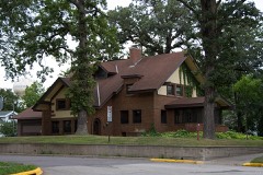 | Merton S. Goodnow House | 4.8 miles | 1985 |
 | Harry Merrill House | 4.8 miles | 2012 |
 | Hutchinson Carnegie Library | 4.9 miles | 1977 |
| National Archives record | The nomination case file for reference 09000622 in Record Group 79. |
| McLeod County | All 7 listed properties in this county. |