 Block
From the record
One of 7 National Register listings published here for McLeod County · listed in 2012 · category: Building.
Sources: the case file at the National Archives · the National Register database, National Park Service
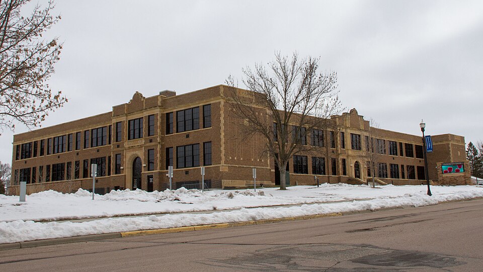
Listed on the National Register of Historic Places in 2012.
One of 7 National Register listings published here for McLeod County · listed in 2012 · category: Building.
Sources: the case file at the National Archives · the National Register database, National Park Service
Regional context, not property-specific evidence. The federal wildfire occurrence database lists 1 fire within 5 miles of Glencoe Grade and High School in 2011, burning about 61 acres in total. None started naturally. None was recorded as arson. Distance is straight-line from the map coordinates, so a fire counted here may appear on a neighbouring settlement's page as well.
| Reported cause | Fires |
|---|---|
| Equipment and vehicle use | 1 |
The most recent of them, most recent first, with the day each was reported and the service that recorded it.
| Date | Cause | Size | Reported by | Name on the report |
|---|---|---|---|---|
| 30 October 2011 | Equipment and vehicle use | 61 acres | Minnesota Department of Natural Resources | not named |
Regional context, not property-specific evidence. The National Weather Service names Glencoe, the town this property stands in, in 73 storm reports between 1997 and 2023: 41 thunderstorm wind, 25 hail, 4 flash flood, 2 funnel cloud. No death or injury is recorded in these reports. Each account below is quoted exactly as the forecast office filed it, from the NOAA Storm Events Database, and each date opens the federal record of that event.
| When | Event | Place named | Harm | What the report says |
|---|---|---|---|---|
| June 2013 | Flash Flood | Glencoe | $75,000 | Overnight rainfall, with high rainfall rates, caused significant street flooding in Glencoe, with flood waters encroaching on homes and businesses during the early morning hours. During the height of the storm, 12 inches of flowing water was reported on area streets in Glencoe. |
| May 2005 | Thunderstorm Wind | Glencoe | $70,000 | The roof of a pole barn (228'x70') was blown off and tossed southeast of the structure. |
| April 2002 | Thunderstorm Wind | Glencoe | $60,000 | Storage barn knocked off foundation. Shingles and portion of tin roof partially blown off. High school football bleachers blown over. Several trees down, including one on car. |
| August 2016 | Thunderstorm Wind | Glencoe | $50,000 | In the town of Glencoe, damage mainly consisted of trees and large branches blown down. There was an evergreen tree in the center of town that got uprooted. The tree damage was scattered throughout the entire city. There were several branches that landed on houses, garages, vehicles, and other items. There was also power outage in mostly the east side of Glencoe. |
| June 2019 | Thunderstorm Wind | Glencoe | $10,000 | Numerous trees were blown down on houses and vehicles, along with power lines in Glencoe. |
| June 2010 | Thunderstorm Wind | Glencoe | $10,000 | A large tree fell on a car. |
| June 2016 | Thunderstorm Wind | Glencoe | $5,000 | A large tree blew down on Main Street in Glencoe. This tree landed on a boat and damaged it. There were also numerous reports of smaller tree branches blown down throughout the city of Glencoe. |
| August 2021 | Thunderstorm Wind | Glencoe | $3,000 | Several large tree branches blew down around the city of Glencoe. One of the branches was 10 inches in diameter and landed on a house. |
| June 2019 | Thunderstorm Wind | Glencoe | $500 | There was a picture of wind, and hail damage to a home in Glencoe. |
| July 2023 | Thunderstorm Wind | Glencoe | - | Two large branches were down and partially blocking a roadway in Glencoe. |
| May 2022 | Thunderstorm Wind | Glencoe | - | Several tree branches and power lines blown down northwest of Glencoe. |
| May 2021 | Funnel Cloud | Glencoe | - | A storm chaser took video of a brief funnel cloud. Ground contact was never noted. |
| May 2018 | Thunderstorm Wind | Glencoe | - | Several large trees, up to 12 inches in diameter, and a few power lines were either snapped or blown down southwest of Glencoe. |
| July 2016 | Hail | Glencoe | - | Several trained spotters and storm chasers observed large hail around Glencoe. The largest size shown in a photo was tennis ball size. |
| July 2014 | Thunderstorm Wind | Glencoe | - | Strong winds caused a large tree to be blown down. Power outages occurred in town. |
| June 2013 | Funnel Cloud | Glencoe | - | Two local observers near Glencoe, captured a photo of a funnel cloud early afternoon of Wednesday, June 5th. |
| August 2012 | Thunderstorm Wind | Glencoe | - | A house roof was partially blown off, with a part of a silo damaged, along with several large trees uprooted. |
| June 2012 | Thunderstorm Wind | Glencoe | - | Several very large trees were uprooted in Glencoe. |
| June 2012 | Flash Flood | Glencoe | - | The city of Glencoe had significant street flooding which caused some streets to close. |
| July 2011 | Thunderstorm Wind | Glencoe | - | Several large trees were blown down around Glencoe, Minnesota. |
| August 2011 | Heavy Rain | Glencoe | - | Minor ponding of water was reported on 16th Street in Glencoe. |
| August 2011 | Thunderstorm Wind | Glencoe | - | Several trees were blown down in Glencoe that blocked city roads. |
| May 2008 | Hail | Glencoe | - | Report located at Hwy. 212 and Falcon Road. |
| August 2007 | Thunderstorm Wind | Glencoe | - | Twelve inch tree blown down. |
| June 2007 | Hail | Glencoe | - | Hail occurred on east side of city. Small tree branches also felled at this location. |
| July 2006 | Thunderstorm Wind | Glencoe | - | A few trees down. |
| September 2006 | Thunderstorm Wind | Glencoe | - | Large branches felled. |
| May 2005 | Thunderstorm Wind | Glencoe | - | A medium sized tree was downed in addition to a few branches. The downed tree broke a window. |
| June 2005 | Thunderstorm Wind | Glencoe | - | A portion of the roof of a trailer home was blown off on Essex Court. |
| June 2005 | Thunderstorm Wind | Glencoe | - | Large branches were downed. |
| June 2005 | Thunderstorm Wind | Glencoe | - | A storage shed was demolished by a downed tree near the intersection of Highway 212 and Imperial Avenue in Glencoe Township, Section 28. |
| September 2005 | Hail | Glencoe | - | Hail damaged cars. |
| September 2005 | Thunderstorm Wind | Glencoe | - | Trees up to 8 inches in diameter were downed near the intersection of 110th Street and Melody Avenue. |
| September 2005 | Thunderstorm Wind | Glencoe | - | Power lines were downed at the intersection of 16th Street and Newton Avenue. Power lines and a few trees were downed in the area of 10th Street and Stevens Avenue. A tree was downed at the intersection of Union Avenue and 11th Street. A tree was downed onto Highway 212 near Morningside Avenue. |
| September 2005 | Thunderstorm Wind | Glencoe | - | Several trees and branches were downed near the intersection of 120th Street and Dairy Avenue. |
| September 2005 | Thunderstorm Wind | Glencoe | - | Tree branches up to 8 inches in diameter were downed onto the westbound lanes of Highway 212 near County Road 9. |
| May 2004 | Thunderstorm Wind | Glencoe | - | A few large trees were downed onto a road. |
| April 2004 | Thunderstorm Wind | Glencoe | - | A shed was downed. |
| April 2004 | Thunderstorm Wind | Glencoe | - | Trees and power lines were downed. |
| May 2004 | Hail | Glencoe | - | Penny sized hail fell in Sumter and at Lake Marion. The time was estimated. |
| July 2003 | Thunderstorm Wind | Glencoe | - | Two trees down. |
| August 2002 | Thunderstorm Wind | Glencoe | - | Thirty trees down, including a few on houses and cars. |
| May 2001 | Thunderstorm Wind | Glencoe | - | Large branches ripped down. |
| June 1999 | Thunderstorm Wind | Glencoe | - | Trees and power lines felled. Estimated windspeed. |
| May 1998 | Thunderstorm Wind | Glencoe | - | Trees down. Roofs ripped off homes. Barns and sheds blown down in vicinity. Semitrailer blown on its side. Estimated windspeed. |
| June 1998 | Thunderstorm Wind | Glencoe | - | Large branch blown down. Estimated windspeed. |
| July 1997 | Thunderstorm Wind | Glencoe | - | Shed damaged. Estimated windspeed. |
| August 1997 | Thunderstorm Wind | Glencoe | - | Trees blown down onto car. Estimated windspeed. |
| July 1997 | Thunderstorm Wind | Glencoe | - | Roof damage to high school. Building under construction toppled at garden center. |
| July 1997 | Flash Flood | Glencoe | - | Heavy rainfall in brief period of time resulted in flash flooding causing the Crow River to overflow its banks and flood highway 22 north of Glencoe. |
| June 1997 | Hail | Glencoe | - | Hail damaged paint and shutters. |
| October 1997 | Thunderstorm Wind | Glencoe | - | Power lines down. Estimated windspeed. |
| May 2022 | Thunderstorm Wind | Glencoe | - | no account filed |
| June 2019 | Hail | Glencoe | - | no account filed |
| May 2016 | Hail | Glencoe | - | no account filed |
| May 2016 | Hail | Glencoe | - | no account filed |
| May 2014 | Hail | Glencoe | - | no account filed |
| April 2012 | Hail | Glencoe | - | no account filed |
| June 2012 | Hail | Glencoe | - | no account filed |
| July 2011 | Hail | Glencoe | - | no account filed |
No historic map-sheet match is published for this property yet. That does not mean no map exists. This record needs a coordinate-quality review before it can be joined to a sheet boundary. Browse the county's mapped places while that work is pending.
Other National Register properties close enough to walk or drive between, ordered by distance from this one. Both positions come from the same geocoding pass that matched these properties to their map sheets.
| Photograph | Property | Distance | Listed |
|---|---|---|---|
 | McLeod County Courthouse | 0.2 miles | 1984 |
| National Archives record | The nomination case file for reference 12000872 in Record Group 79. |
| McLeod County | All 7 listed properties in this county. |