
BlockBefore
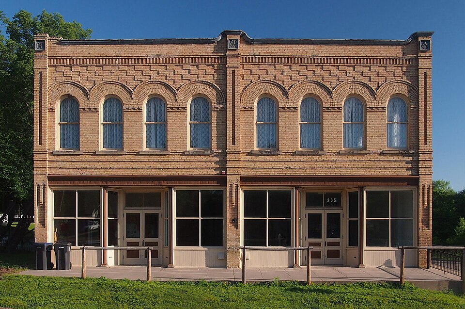
Photograph of Clearwater Masonic Lodge
Photograph by McGhiever, CC BY-SA 4.0. Via Wikimedia Commons.

Clearwater Masonic Lodge-Grand Army of the Republic Hall

Listed on the National Register of Historic Places in 1979.

From the record

“The Clearwater Masonic and Grand Army of the Republic Hall is a historic building in Clearwater, Minnesota, United States, constructed in 1888. It has served as a meeting hall for both a local Grand Army of the Republic (GAR) post, and a local Masonic Lodge, with commercial space on the ground floor.”

Wikipedia article Clearwater Masonic and Grand Army of the Republic Hall, CC BY-SA 4.0.

One of 22 National Register listings published here for Wright County · listed in 1979 · category: Building.

Sources: the Wikipedia article · the case file at the National Archives · the National Register database, National Park Service
The listing

  • What is counted as historic. The nomination lists 1 building as contributing to the listing.
  • Address. 205-215 Oak St., Clearwater, 55320
  • When was it listed? December 1979
  • Category. building
  • Also known as. Wright County MRA
  • City. Clearwater city
  • Architectural style. Italianate architecture
  • National Register reference number. 79001259 - the number the National Park Service assigned this property when it was listed, and the key its nomination file is catalogued under at the National Archives.

The ground it stands on

3,362 words

The chapter on Clearwater City in History of Wright County, Minnesota Volume II, published 1915 names Clearwater. This is what it says, exactly as the scans read.

Clearwater is the most northern of the political divisions of Wright county. It embraces all that part of Congressional township 122, range 27, that lies east of the Clearwater river; a small portion of seetions 34 and 35, in township 123, range 27, in the triangle formed by the juncture of the Clearwater and Mississippi rivers, and sections 7, 17 and 18 and fractional sections 5, 6 and 8, in township 122, range 26.

Passage source: History of Wright County, Minnesota Volume II, published 1915.

The surface is rolling, and in the northern part was originally principally prairie, bordered by a narrow belt of timber skirting the river, while south it merged into brushland, beyond which was a heavy timber land. Numerous fine lakes are found throughout the town, and two of more considerable size make slight encroachments from the town of Corinna on the south. Some good natural meadow land is found in the southern portion and along the Mississippi in the northern part. The soil in the prairie portion is a dark sandy loam with clay subsoil, and produces excellent crops; in the portion originally timbered it is clay and dark loam and is unsurpassed for fertility. For many years the cultivated area of this town was proportionately greater than in any other town in the county, but with the development of modern improvements in other localities in the county, Clearwater lost this distinction.

Passage source: History of Wright County, Minnesota Volume II, published 1915.

Machine-read from a century-old scan, so expect the errors a machine makes: misspelled names, dropped words, stray characters.

Read the whole chapter on Clearwater City - 3,362 words on its settlement, mills, schools and churches.

Fires near this property

57 since 1992

Regional context, not property-specific evidence. The federal wildfire occurrence database lists 57 fires within 5 miles of Clearwater Masonic Lodge-Grand Army of the Republic Hall between 1992 and 2020, burning about 500 acres in total. None started naturally. 6 were recorded as arson. Distance is straight-line from the map coordinates, so a fire counted here may appear on a neighbouring settlement's page as well.

Reported cause Fires
Debris and open burning31
Railroad operations and maintenance12
Arson/incendiarism6
Equipment and vehicle use3
Missing data/not specified/undetermined3
Recreation and ceremony1
Smoking1

The most recent of them, most recent first, with the day each was reported and the service that recorded it.

DateCause SizeReported by Name on the report
30 September 2000Missing data/not specified/undeterminedunder an acreMinnesota Department of Natural Resourcesnot named
24 September 1993Equipment and vehicle use3.0 acresMinnesota Department of Natural Resourcesnot named
27 August 2003Smokingunder an acreMinnesota Department of Natural Resourcesnot named
24 August 2000Debris and open burning1.5 acresMinnesota Department of Natural Resourcesnot named
13 August 1996Railroad operations and maintenance1.5 acresMinnesota Department of Natural Resourcesnot named
21 June 2008Railroad operations and maintenanceunder an acreMinnesota Department of Natural Resourcesnot named

Every fire recorded in Wright County

Storms near this property

19 since 1997

Regional context, not property-specific evidence. The National Weather Service names Clearwater, the town this property stands in, in 19 storm reports between 1997 and 2025: 11 hail, 7 thunderstorm wind, 1 tornado. No death or injury is recorded in these reports. Each account below is quoted exactly as the forecast office filed it, from the NOAA Storm Events Database, and each date opens the federal record of that event.

WhenEvent Place namedHarm What the report says
July 2010Tornado (EF0)Clearwater$100,000Hundreds of trees were snapped or uprooted, roofs removed from sheds, and several outbuildings destroyed. A house sustained minor damage, with the roof partially removed above a porch, and some shingles and siding removed.
April 2025HailClearwater-Photo provided via social media.
July 2023HailClearwater-Mostly dime size hail with some quarter size hail mixed in. Photo relayed through social media.
June 2015HailClearwater-There were several reports of penny to nickel size hail from south of Clearwater, east to Interstate 94. The largest hail stone was quarter size, south of Clearwater.
May 2012Thunderstorm WindClearwater-A Minnesota Department of Transportation wind sensor measured a wind gust of 59 knots.
June 2010Thunderstorm WindClearwater-This was a measured wind gust at a Minnesota Department of Transportation Weather Station.
June 2010Thunderstorm WindClearwater-Multiple trees were blown down near Clearwater, Minnesota.
August 2007HailClearwater-Estimated winds of 40-50 mph.
June 2005Thunderstorm WindClearwater-The top half of a chicken barn was blown off along 17th Avenue in Linden Township.
July 2005Thunderstorm WindClearwater-A tree was downed across Highway 24.
July 1997Thunderstorm WindClearwater-Windows blown in at apartment building. Trees down.
July 2024HailClearwater-no account filed
May 2022Thunderstorm WindClearwater-no account filed
August 2008HailClearwater-no account filed
July 2007HailClearwater-no account filed
May 2006HailClearwater-no account filed
August 2006HailClearwater-no account filed
April 2002HailClearwater-no account filed

Every storm recorded in Wright County

Map coverage status

No historic map-sheet match is published for this property yet. That does not mean no map exists. This record needs a coordinate-quality review before it can be joined to a sheet boundary. Browse the county's mapped places while that work is pending.

Listed places nearby

2 within 8 miles

Other National Register properties close enough to walk or drive between, ordered by distance from this one. Both positions come from the same geocoding pass that matched these properties to their map sheets.

Photograph PropertyDistance Listed
William W. Webster Houseunder 500 feet1979
First Congregational Church of Clearwater0.2 miles1979

Sources for this property

National Archives recordThe nomination case file for reference 79001259 in Record Group 79.
Wikipedia articleCommunity-written account of this property, licensed CC BY-SA.
Wright CountyAll 22 listed properties in this county.

Provenance

  • Listing record. National Park Service National Register of Historic Places, listed-properties dataset, current to 2026-05-22.
  • Map join. Address geocoded through the United States Census geocoder, then tested against the published boundary of every sheet in the USGS Historical Topographic Map Collection.
  • How this page is made. Listing fields come from federal records; map-sheet coverage is a labelled coordinate-to-boundary calculation, not a source-field claim.
  • Wildfire. Short, Karen C. 2022. Spatial wildfire occurrence data for the United States, 1992-2020 [FPA_FOD_20221014]. 6th Edition. Fort Collins, CO: Forest Service Research Data Archive. https://doi.org/10.2737/RDS-2013-0009.6 Collected with United States Government funding and usable without additional permissions or fees.
  • Storms. NOAA National Centers for Environmental Information, Storm Events Database https://www.ncei.noaa.gov/stormevents/ A work of the United States government, no copyright under 17 U.S.C. 105. Narratives are quoted verbatim from the National Weather Service report and are not edited or summarised.